| Pages:
1
2 |
PaulW
Ultra Nomad

Posts: 3009
Registered: 5-21-2013
Member Is Offline
|
|
Pioneer mine road
A repeat so the write up can be found with the search tool
Trip description for Pioneer Mine Road First day of a 5 day edventure
Day 1 - 1/18/2018
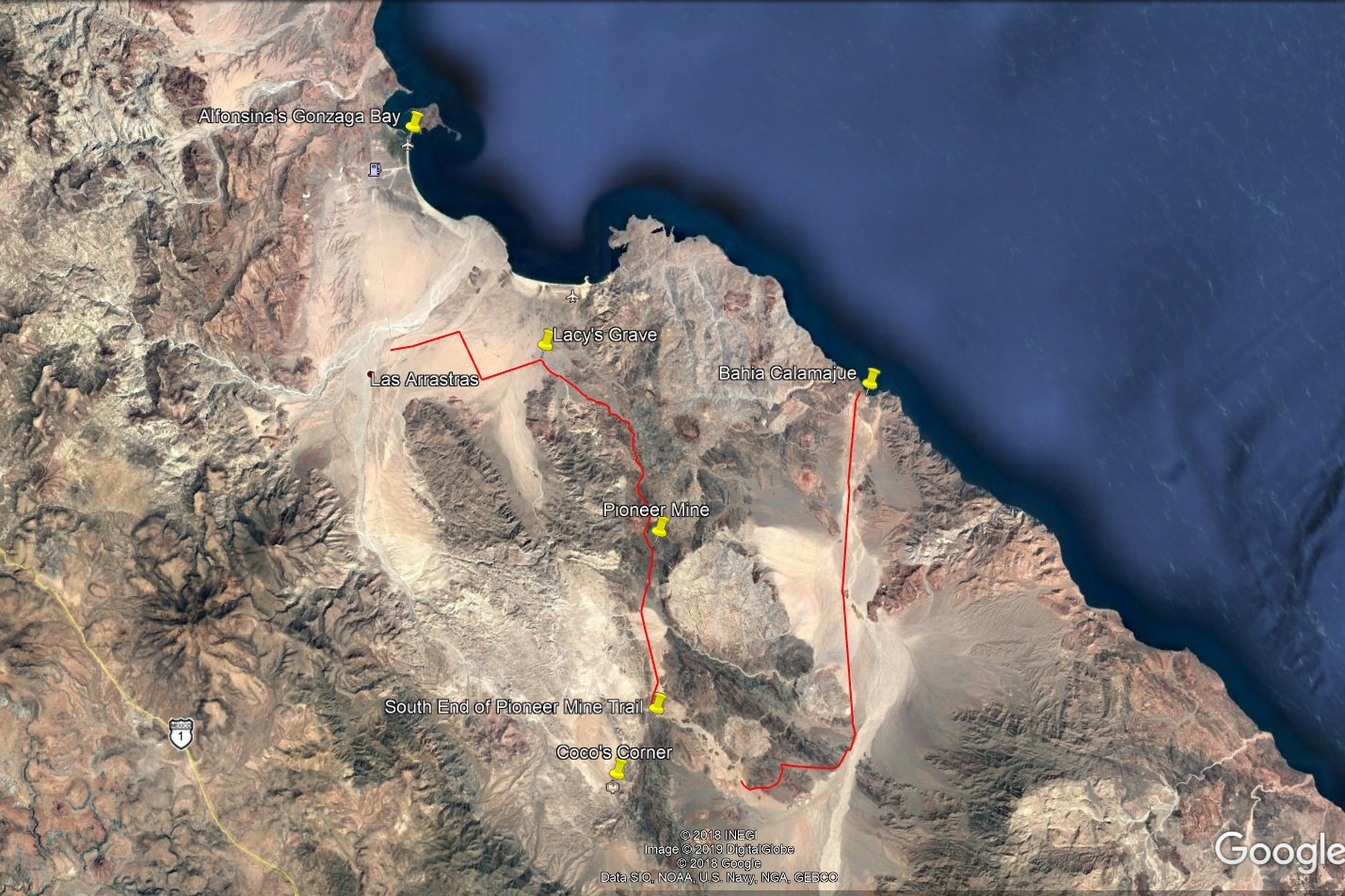
San Felipe to Hwy5K156 to begin the Pioneer Mine road heading South thru Calamajue and El Crucero then to LAB
Started in San Felipe and drove the highway to just south of Gonzaga. Then drove east to the subject road which is a track between Hwy1 and Punta
Final via El Crucero / Calamajue . Spend night in a hotel in LAB. The road on the north side of the mountain was difficult. It was way overgrown with
heavy bushes. Did not need lockers but used 4Lo mostly and 15 psi for my rig. Huge rocks to drive over. Everybody made it thru ok. Rigs were my
Unlimited TJ with 35” tires. Rich’s CJ rock crawler with 39” tires and stretched wheel base. Two late model JK 4 door rigs, one with 33” and
the other with 37”. One TJ with 33” tires. These guys are very experience their rock crawling days (In other rigs). Lots of new scratches on all
rigs. I searched many sources and could not find a decent depiction to the road we took. We now have it with my tracks on GE as well as GPS tracks
Details: Leave Hwy5 at ~K156 and head east along good roads to the start of the trail. Arrive at El Crucero at Hwy 1 at K261
Here are my collection of maps for the day:
Google Earth Image

From my Inreach 10 minute data points

====
edit:
attached is the .USR GPS file for you to play with
Attachment: Pioneer Mine Rd.usr (80kB)
This file has been downloaded 292 times
[Edited on 2-17-2018 by PaulW]
|
|
|
David K
Honored Nomad
Posts: 64491
Registered: 8-30-2002
Location: San Diego County
Member Is Offline
Mood: Have Baja Fever
|
|
Thank you... The new thread will help indeed.
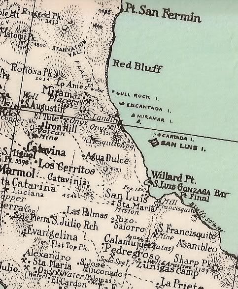
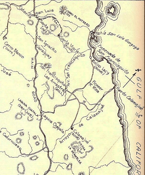
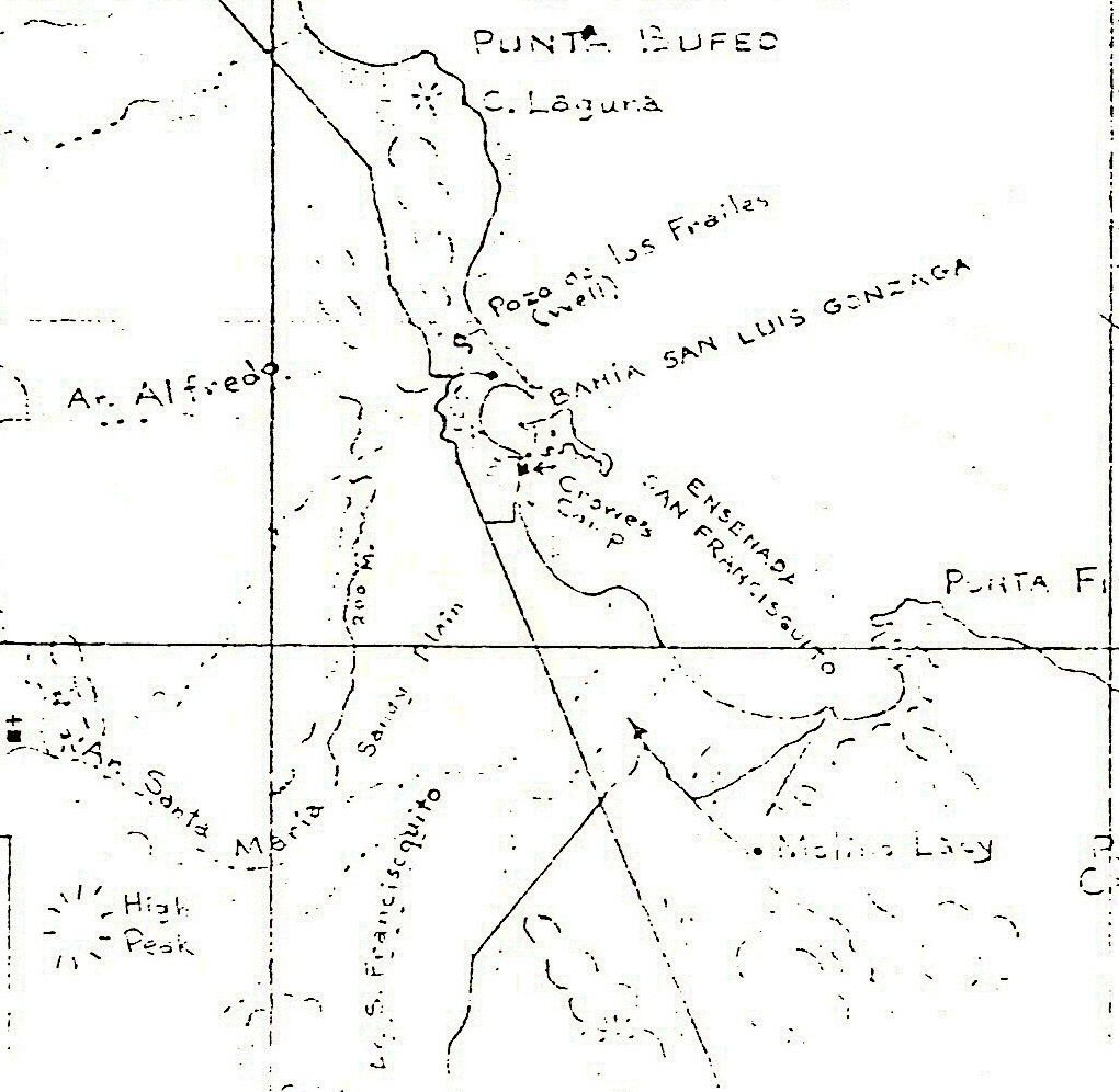
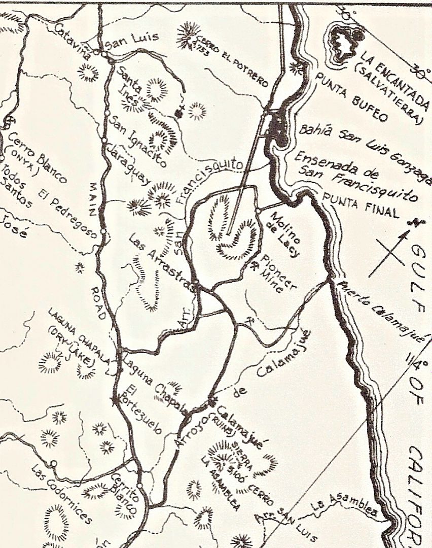
Here are the historic maps that show the wagon road and later, 4x4 road:
1905:
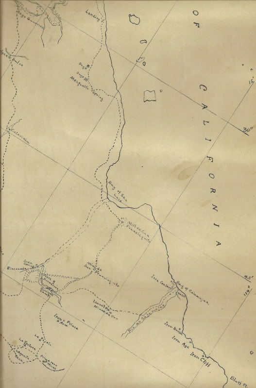
Molino de Lacy was Molino (Mill) de San Francisquito and the Pioneer Mine was Mina San Francisquito.
1930:
1956:
1960:
1962:
|
|
|
PaulW
Ultra Nomad
Posts: 3009
Registered: 5-21-2013
Member Is Offline
|
|
David, For completeness could you list the various threads for the mine road?
|
|
|
Fatboy
Senior Nomad
Posts: 716
Registered: 6-28-2005
Member Is Online
|
|
Very interesting route. Any background on it such as when it was used and why?
|
|
|
PaulW
Ultra Nomad
Posts: 3009
Registered: 5-21-2013
Member Is Offline
|
|
Before Highway 5 was even a vision that path/trail was the road from El Crucero to Pt. Final and further north. Of course the weather has done a lot
of destruction. Even recently the track has change quite a bit from runs done in the last few years.
|
|
|
Ken Cooke
Elite Nomad
Posts: 8921
Registered: 2-9-2004
Location: Riverside, CA
Member Is Offline
Mood: Black Trans Lives Matter
|
|
Most difficult!
|
|
|
David K
Honored Nomad
Posts: 64491
Registered: 8-30-2002
Location: San Diego County
Member Is Offline
Mood: Have Baja Fever
|
|
Historically, the Pioneer Mine side of the mountain was the logged road in the 1950s but the Las Arrastras side was mentioned as a sandy alternate to
Gonzaga.
In the 1960s the Las Arrastras side was more popular and much nicer to drive than the Pioneer Mine side.
Later, the Pioneer Mine side would be just a motorcycle route and by the late 1980s the graded road was built on the Las Arrastras side.
Paul, ok I will work on that list, but until then, a search for Pioneer Mine or Molino de Lacy should find any posts with mention of this road.
|
|
|
PaulW
Ultra Nomad
Posts: 3009
Registered: 5-21-2013
Member Is Offline
|
|
Trail names used by various sources:
"Pioneer Mine Road", or "Molino de Lacy road", or Lizard Lady's "Mine Pass Trail" or “Mine Trail”
|
|
|
6WHEELN
Newbie
Posts: 20
Registered: 2-16-2017
Location: San Diego
Member Is Offline
|
|
It is actually very simple to find the Pioneer Mine Trail.
Here are the directions:
1. Go to Baja California.
2. Drive through the desert.
3. When you get to the cactus next to the rock, turn left.
https://youtu.be/jrrs0Iywe-s
|
|
|
David K
Honored Nomad
Posts: 64491
Registered: 8-30-2002
Location: San Diego County
Member Is Offline
Mood: Have Baja Fever
|
|
Thanks for the video... fun hearing the story via the 2-way radio.
The road was first a wagon road to bring the gold ore to the mill (Molino de San Francisquito, renamed Molino de Lacy). It was made passable to autos,
possibly by Arturo Grosso of Laguna Chapala when he blasted the first pilot road to San Felipe (to the sulfur mine) from his ranch and collected the
reward money from the governor (circa 1955-56).
|
|
|
JZ
Elite Nomad
Posts: 9269
Registered: 10-3-2003
Member Is Offline
|
|
Gave it a shot a year ago and my kid's bike overheated with a radiator problem. We turned tail and went back. Gonna give it another go soon.
Here's the route.
Attachment: Rt Pioneer Mine Trail.kmz (3kB)
This file has been downloaded 260 times
[Edited on 3-13-2019 by JZ]
|
|
|
Ken Cooke
Elite Nomad
Posts: 8921
Registered: 2-9-2004
Location: Riverside, CA
Member Is Offline
Mood: Black Trans Lives Matter
|
|
I always wondered if the Pioneer Trail and Molino de Lacy were synonymous. It was a very fun trail. Rich T. took us on an epic trail that day. I'm
wanting to go back soon, because that was the best consecutive trail run I've ever been on.
[Edited on 3-13-2019 by Ken Cooke]
|
|
|
David K
Honored Nomad
Posts: 64491
Registered: 8-30-2002
Location: San Diego County
Member Is Offline
Mood: Have Baja Fever
|
|
Quote: Originally posted by Ken Cooke  | I always wondered if the Pioneer Trail and Molino de Lacy were synonymous. It was a very fun trail. Rich T. took us on an epic trail that day. I'm
wanting to go back soon, because that was the best consecutive trail run I've ever been on.
[Edited on 3-13-2019 by Ken Cooke] |
You began the trail at Molino de Lacy (see the maps I posted).
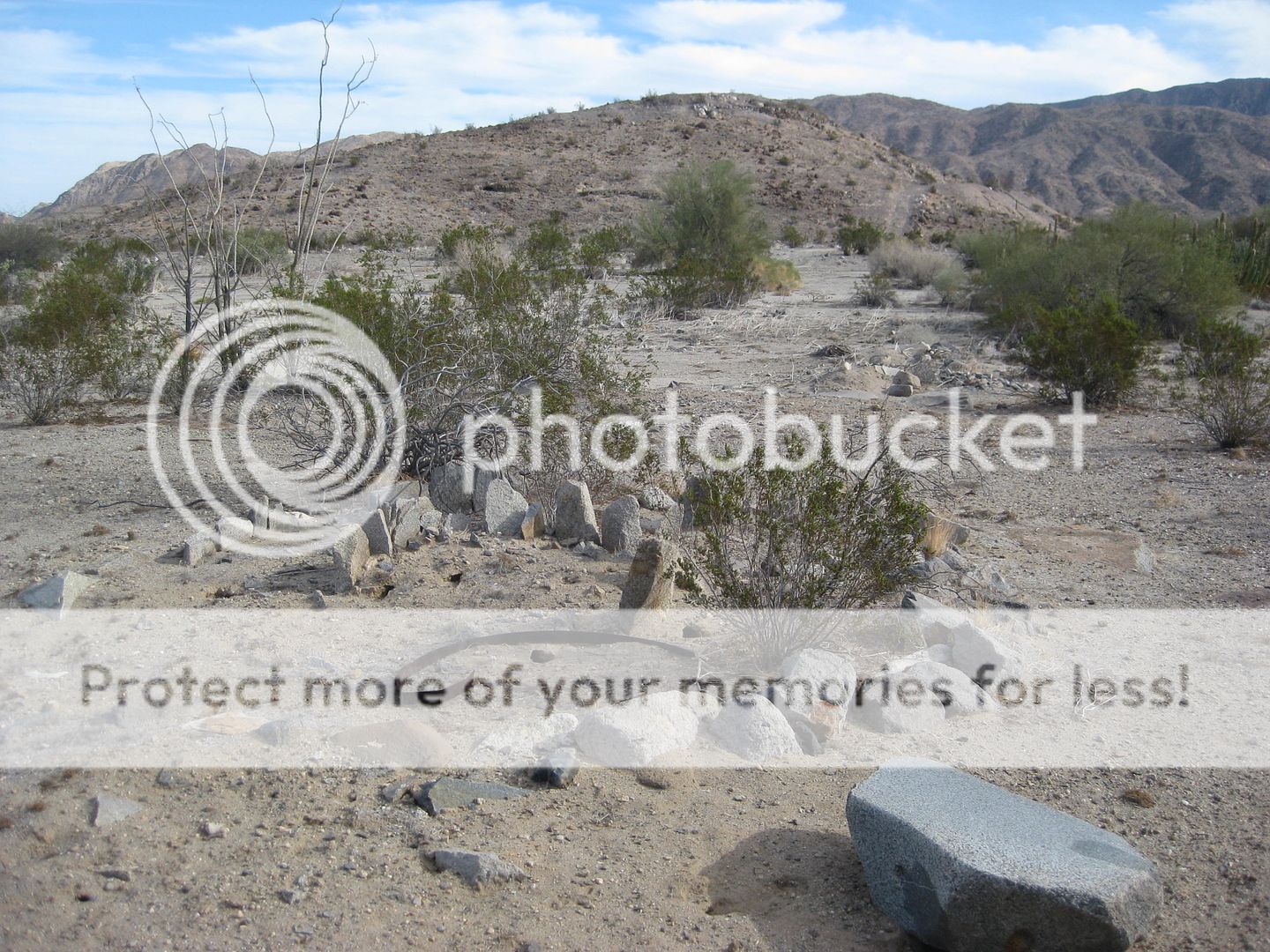
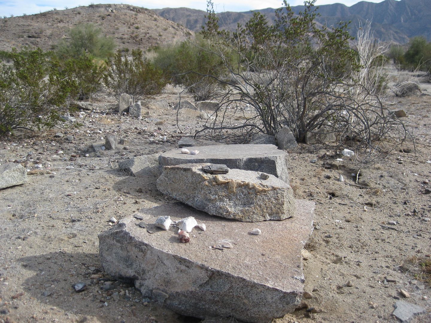
It is the hill where you turned south from the road that heads to Punta Final.
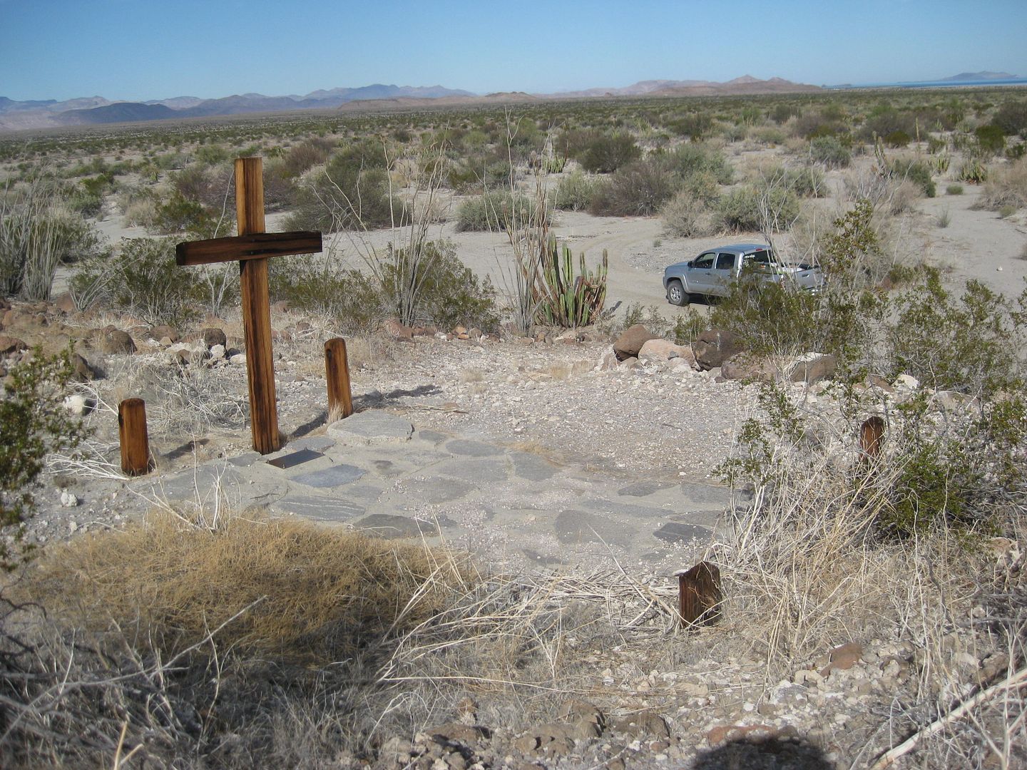
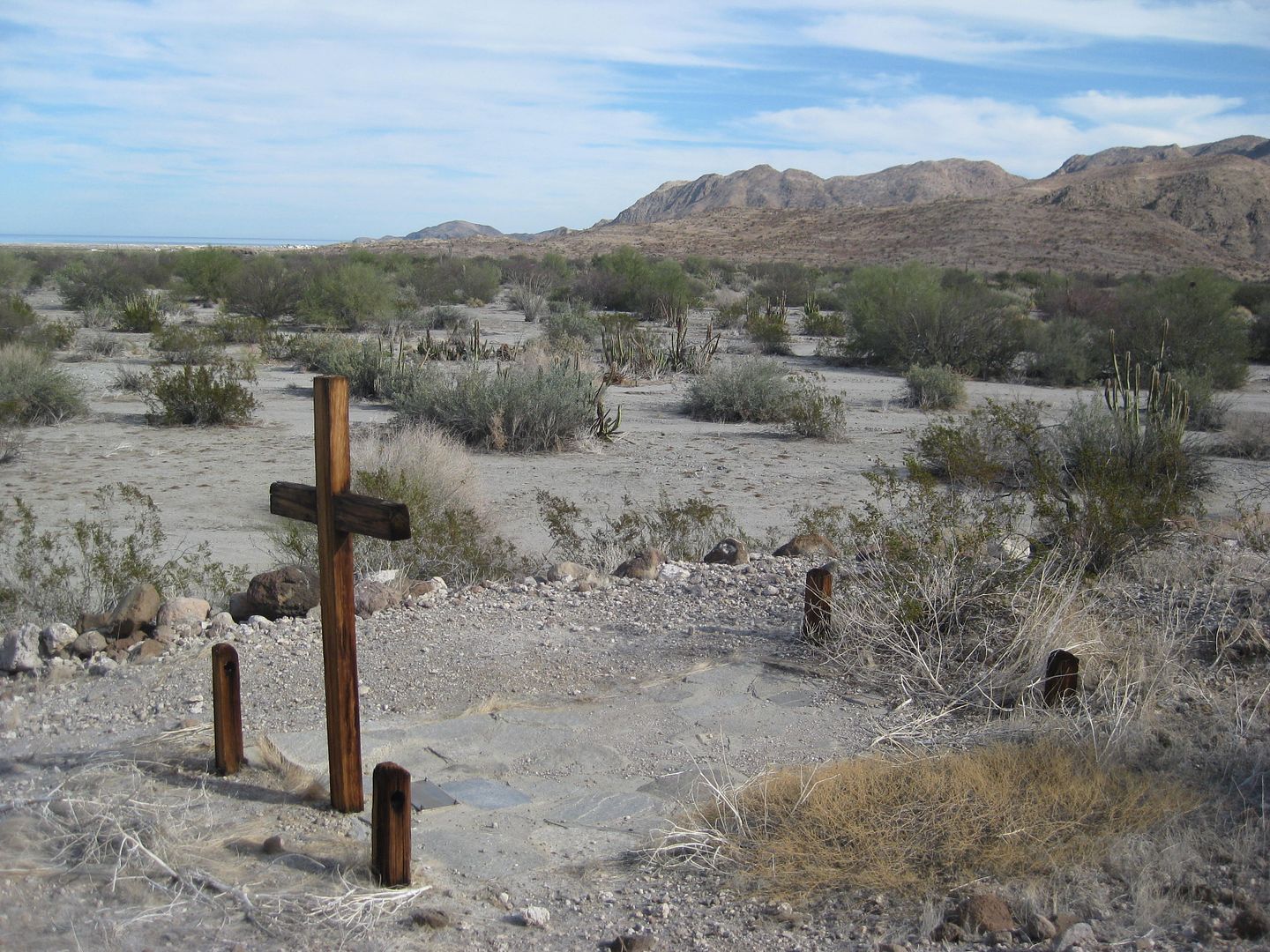
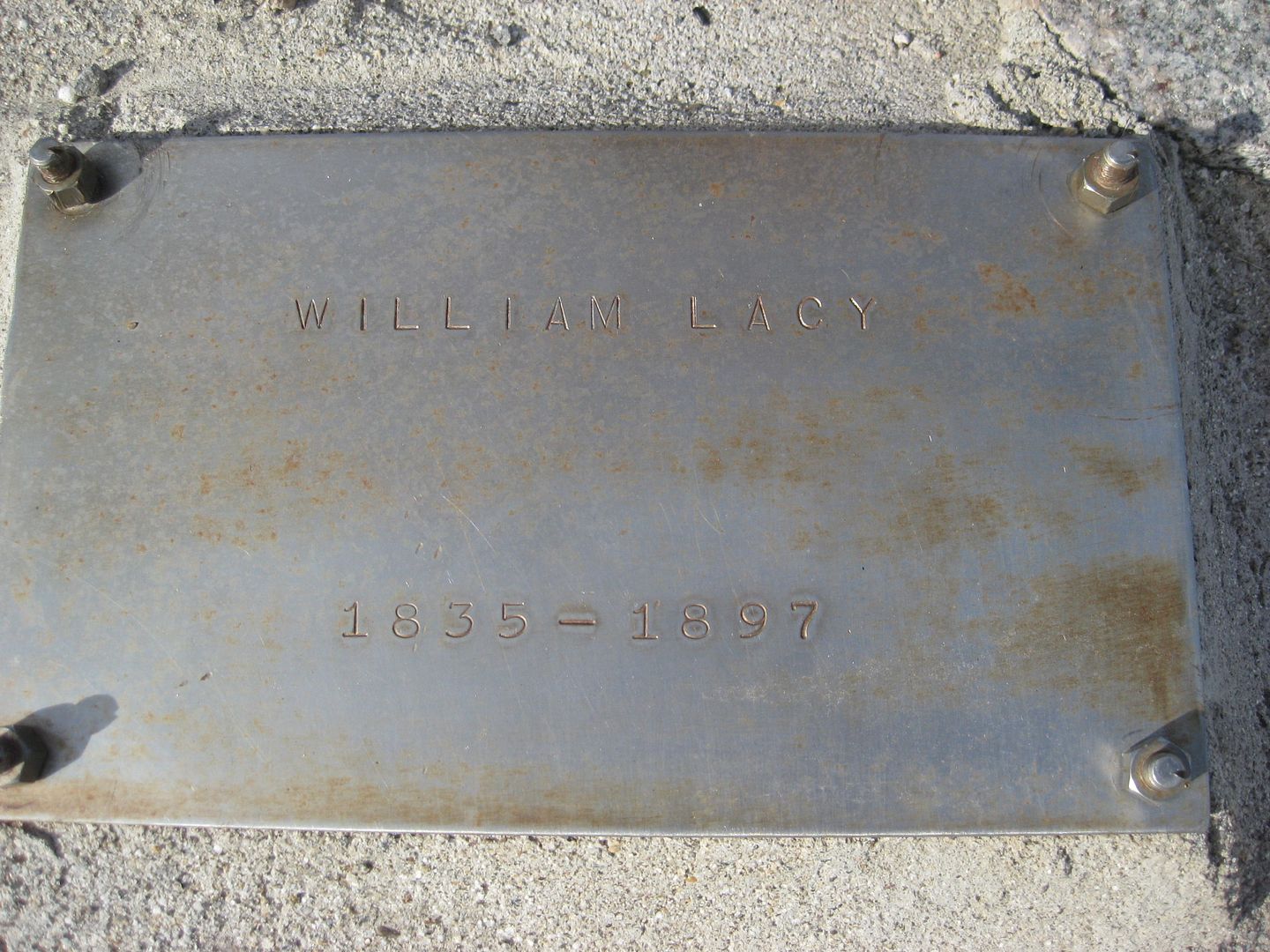
The hill has a road going up it and William Lacy's grave is on the east side of the hill.
2002 photos (from VivaBaja.com):

Located between Hwy. 5 and Punta Final, this mill processed gold ore over 100 years ago. Operated by William Lacy, who is buried on the opposite side
of this hill.

Located on the east side of the hill, facing Punta Final. Chris, age 13, stands by the grave.
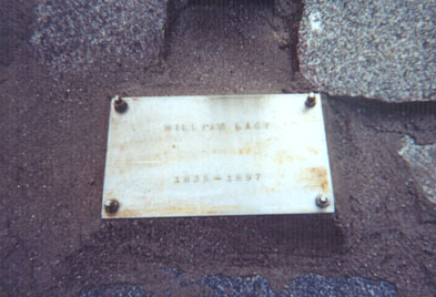
Well preserved plaque of the man who must have faced some fantastic struggles in this harsh land.

Looking south, thunder and lightning with occasional showers this Thanksgiving day. The old road south to the mines and on to Coco's begins on the
right side of the photo. Mostly just dirt bikes use it now.
2017:

|
|
|
6WHEELN
Newbie
Posts: 20
Registered: 2-16-2017
Location: San Diego
Member Is Offline
|
|
| Quote: Originally posted by Ken Cooke | I always wondered if the Pioneer Trail and Molino de Lacy were synonymous. It was a very fun trail. Rich T. took us on an epic trail that day. I'm
wanting to go back soon, because that was the best consecutive trail run I've ever been on.
[Edited on 3-13-2019 by Ken Cooke] |
Yes, Pioneer Mine Trail plus Calamajué Canyon followed by Mission Impossible was amazing, truly epic. The combination of fun off-road driving with
abundant technical challenges, beautiful and diverse scenery in remote settings, and fascinating history with the ruins to visit is hard to beat. Ken,
please let me know if you want to do it again and I’ll try to join you.
|
|
|
JZ
Elite Nomad
Posts: 9269
Registered: 10-3-2003
Member Is Offline
|
|
|
|
|
ztrab
Junior Nomad
Posts: 46
Registered: 2-16-2005
Member Is Offline
|
|
I like to check out the spring and mineral accumulation just south of where you exit the wash for the hard pack trail. I loaded my track for
Calamajue to Alfonsina's via the Pioneer trail for two jack rabbits that wanted to run ahead but told them not to take it to Alfonsina's as we were
going to Coco's then over to Catavina for the night so we could do the west 22 day trail on the way to El Rosario the next day. I should have marked
the turn but it is so obvious to me that I figured they would stay on the main road (one of them had been to Cocos and they had the way point ...) so
we left a note with Coco and a message on their InReaches. They spent the night at Alfonsina's- lol - and made it over to Catavina in time to watch
us finish our leisurely breakfast. The trail was a little rough but nothing too bad. I'm pretty much done with the new and improved Alfonsina's and
the trail options going north are meh. Ran into Mulege Al at the Turistica hotel - joined us fro dinner, pretty funny dude, fit right in. oh yeah,
the 22 day trail and bits between Catavina and El Rosario were still damp and the vegetation was lush.
|
|
|
brumsky
Junior Nomad
Posts: 32
Registered: 1-18-2019
Member Is Offline
|
|
Agreed about Alfonsinas. Last time we went we emailed and made a reservation. We showed up they were full and 'lost' our reservation. No problem, we
went to go sleep on the beach in our sleeping bags. They came out an hour later, got us up, and told us we had to sleep in our trucks. Said it was
against the rules to sleep on the beach. Pretty awesome....
El Sacrificio from now on.
|
|
|
brumsky
Junior Nomad
Posts: 32
Registered: 1-18-2019
Member Is Offline
|
|
Does anyone have a waypoint or gps coordinates they could share for the grave site or the actual mine? I've been through the road several times but
have not had a chance to see either. Thank you in advance.
|
|
|
David K
Honored Nomad
Posts: 64491
Registered: 8-30-2002
Location: San Diego County
Member Is Offline
Mood: Have Baja Fever
|
|
It's on my website, or you can use Google Earth and just see it if you can put the mouse on the Molino de Lacy hill... http://www.vivabaja.com/GPS/page3.html
The GPS waypoint on my old list is set to NAD27 Mexico, so just switch your GPS setting to that and switch back to the standard WGS 84.
If you need help, I can get it off Google Earth for you.
|
|
|
4x4abc
Ultra Nomad
Posts: 4166
Registered: 4-24-2009
Location: La Paz, BCS
Member Is Offline
Mood: happy - always
|
|
grave site 29°42'29.71"N, 114°19'39.88"W
Pioneer Mine 29°37'29.97"N, 114°16'8.06"W
Mina San Francisquito 29°37'33.98"N, 114°16'14.27"W
"new" gold mine 29°37'40.85"N, 114°17'2.93"W
Mina Sin Nombre 29°37'44.80"N, 114°16'24.57"W
Harald Pietschmann
|
|
|
| Pages:
1
2 |


