| Pages:
1
2 |
Luna_tik
Newbie
Posts: 4
Registered: 2-21-2018
Member Is Offline
|
|
First Time In Baja
Setting out in a couple weeks, but I've been planning for months. Think I've got a pretty good idea of what to prepare for, but it seems smart to run
it by the pros first to see what I missed...
Route: Driving my campervan in at Los Algodones, then over to Mexico 5. Figure I'll follow that down to where it intersects with Mexico 1, then follow
that back up and out through Tijuana. That's probably enough for a newbie gringo traveling alone, hopefully I'll get down to Baja California Sur on
the next trip.
Destinations: Playa Hawaii, Puerticitos Hot Springs (thanks to this forum for putting that on my radar!), Catavina (to find hiking and climb on some
rocks), Camalu, Bahia San Luis Gonzaga, Ensenada, El Rosario, La Lobera (sea lion sanctuary!). Wondering if I should also make the slight detour to
check out Guadalupe. Are there other destinations on this route not to be missed?
Preparedness: I'm aware that I need to carry extra everything; tire, gas, water, etc., and not drive at night. Also not planning to chance it with any
off-roading since I'll be solo. Got all my usual camping/survival gear. I've been told it's a good idea to carry a spare "fake" wallet just in case,
and not to drink the tap water. Hablo un poco Espanol, pero no muy bueno. I've also been advised to purchase Mexican auto insurance. Are the websites
where you can buy it ahead of time legit? What else am I forgetting?
The main things I think I could use more info on at this point are:
Campsites: Mostly interested in good nature spots to park over actual campgrounds, though I'll be visiting a few of those too. More difficult to find
wild campsites than kept grounds online, can anyone recommend some good ones along the route? Are the Mexican Authorities generally ok with car
camping on public land or no?
Bathrooms: How hard are these to find? I've heard mixed stories. I assume while on the road I can un-fill myself while filling the gas tank, but are
there rest stops on long stretches of highway? Camping sounds like it's provided potties with paid campgrounds, otherwise that's what the shovel is
for. Please LMK if I'm wrong.
Toll Booths: Are there a lot of them on this route? Wondering how much I should budget for that.
Military Checkpoints: Still not entirely sure what I'm in for here. I understand that they're mostly looking for drugs or guns (not a problem, won't
be carrying either), and that they may or may not speak English. What Spanish do I need to know to communicate with them? What is the standard
procedure like?
I'll also keep reading other threads on here up until I hit the road. This place is a valuable source of information, and I appreciate any
ideas/advice anyone would be willing to share to help fill the holes in my prep. Thanks, all!
~~~~~~~~~~~~~~~~~
Home is wherever you park
|
|
|
tobias
Nomad

Posts: 188
Registered: 1-10-2014
Member Is Offline
|
|
If you have time , you should pop down to at least mulege before heading back up.
|
|
|
TMW
Select Nomad
Posts: 10659
Registered: 9-1-2003
Location: Bakersfield, CA
Member Is Offline
|
|
Have fun is number one.
There are campsites or just drive way off the road and camp almost anywhere. Best to be far away from any road or highway so as not to be seen. A
really good book on camping in Baja is "Camping Mexico's Baja" by Mike and Terri Church.
Bathrooms are at all the PEMEX stations. The toll roads have them as well. You can always pull off the road for a "pit stop" as they are called.
The toll roads are from TJ to Ensenada (1D) and from TJ to Mexicali (2D).
The Military check points are for guns and drugs. They do speak more English than they let onto. They usually want to know where you came from and
where are you going usually meaning what city. I just give them the last large town I was at and the next big town I'm going to, such as I'm from
Mexicali and going to San Felipe. They may ask you to get out of the vehicle so they can inspect it. Don't leave anything of value in sight of where
they are looking. They may be honest but not always.
Normal Spanish words are great to use and saying gracias often with a smile is appreciated. Bring a Spanish to English and English to Spanish
dictionary or similar book with you to help.
Read David K's trip reports from last year for places to see and go, I think he did 7 of them. A lot of good up to date info.
[Edited on 2-23-2018 by TMW]
|
|
|
John Harper
Super Nomad
Posts: 2289
Registered: 3-9-2017
Location: SoCal
Member Is Offline
|
|
Quote: Originally posted by Luna_tik  | | Preparedness: I'm aware that I need to carry extra everything; tire, gas, water, etc., and not drive at night. Also not planning to chance it with any
off-roading since I'll be solo. Got all my usual camping/survival gear. I've been told it's a good idea to carry a spare "fake" wallet just in case,
and not to drink the tap water. Hablo un poco Espanol, pero no muy bueno. I've also been advised to purchase Mexican auto insurance. Are the websites
where you can buy it ahead of time legit? What else am I forgetting? |
Tire repair kit, quality inflator, jumper cables, transfer pump for liquids, good shovel, toolkit. Some of the paved roads are far worse than the
dirt roads.
Probably cheaper to just get annual Mex insurance. There are lots of online sources.
John
[Edited on 2-23-2018 by John Harper]
|
|
|
Luna_tik
Newbie
Posts: 4
Registered: 2-21-2018
Member Is Offline
|
|
Great advice, TMW, thanks for sharing! I will look for David K's trip reports.
John, I've already got most of those things. What is the transfer pump for? Are the online insurance sources legit then?
|
|
|
John Harper
Super Nomad
Posts: 2289
Registered: 3-9-2017
Location: SoCal
Member Is Offline
|
|
| Quote: Originally posted by Luna_tik | | John, I've already got most of those things. What is the transfer pump for? Are the online insurance sources legit then? |
Easier than using a siphon if you need it. Only about $7 at Harbor Freight. They come in real handy for all kinds of things.
Have not had a claim, but I certainly hope so. I use Lewis and Lewis, but Bajabound is a sponsor here I believe.
John
|
|
|
DanO
Super Nomad
Posts: 1923
Registered: 8-26-2003
Location: Not far from the Pacific
Member Is Offline
|
|
Lewis & Lewis are legit and have short term as well as annual policies.
https://www.mexicanautoinsurance.com/
\"Without deviation from the norm, progress is not possible.\" -- Frank Zappa
|
|
|
Maderita
Senior Nomad
Posts: 638
Registered: 12-14-2008
Location: San Diego
Member Is Offline
|
|
For insurance, I go through BajaBound
https://www.bajabound.com/
They have a reputation for helpfulness and answering questions.
Afaik, Discover Baja and Sanborn's are good too.
http://www.discoverbaja.com/mexican-auto-insurance/
https://www.sanborns.com/
How many days/weeks do you have?
Sounds like you are looking for some adventure, hiking and scrambling rocks (or bouldering with climbing shoes and chalkbag?)
Somewhat out of your way, 50 miles from Mexicali, is a beautiful palm canyon with camping, hot springs, stream coming down from the mountains, hiking
and lots lots of granite boulders. Worth the side trip. 30 miles of dirt road, frequently traveled, 2WD. The right time of year through April for this
desert destination.
http://guadalupecanyonoasis.com/index.html
The drive from Mexicali to San Felipe is boring flat desert. A longer alternative with opportunities for adventure is to drive back north after
Guadalupe Canyon to Hwy 2. Drive west up the grade to La Rumorosa on the Sierra de Juarez plateau. Then drive south on dirt roads through pinyon pine
forest toward the Parque Nacional at Laguna Hanson. Side trip to Canyon el Tajo for hiking, bouldering, wilderness camping below 300' granite domes.
Rancho el Topo turnoff at KM35.5 to visit a working cattle ranch among the big pine trees, elevation 5,000', camping, horseback riding at very
reasonable rates.
14 miles further south is Laguna Hanson a small mountain lake surrounded by pines and granite boulders/crags. Gets a bit busy with weekend campers,
probably quiet mid-week. Continue south on dirt roads to intersect with Hwy 3 east of Ojos Negros. Drive southeast on Hwy 3 toward Hwy 5 and San
Felipe.
So much to do, no matter how many days/weeks you have, it's likely that you will be planning your next trip before you return home!
Ditto on John Harper's equipment list. Add: a tarp/sunshade, either sturdy pop-up type or attach to the side of the van.
|
|
|
bajaric
Senior Nomad
Posts: 610
Registered: 2-2-2015
Member Is Offline
|
|
Passport. Pemex have bathrooms. For a first trip paid camping areas can be a good option --
|
|
|
PaulW
Ultra Nomad
Posts: 3018
Registered: 5-21-2013
Member Is Offline
|
|
Luna,
You mentioned Playa Hawaii, Now days it is called "Pete's Camp, El Parisio". Most of the old maps and nearly all the device maps have it wrong.
Signs on the highway will guide you. Good camping on the beach if it is not a holiday or race weekend when it fills up. Hwy 5 Km 177.7
|
|
|
David K
Honored Nomad
Posts: 64541
Registered: 8-30-2002
Location: San Diego County
Member Is Offline
Mood: Have Baja Fever
|
|
Hi Luna-tik,
Welcome to Nomad!
Everything seems to work out in Baja so try not to stress.
My first time driving myself was when I was 16, in 1974 and haven't stopped since! I have never been robbed or hassled (much). Camping is my main
thing but there are a few choice motels for clean up or when it isn't convenient to set up a tent.
As TMW posted, I did 7 trips in 2017 to try and cover as much of Baja's best for a new Guide. The trip reports are in the Nomad Trip Reports forum and
numbered TRIP # 1-7, plus a family camping trip to Shell Island on Memorial Day. Shell Island is a beautiful barrier island beach, but requires 4WD
(and low tide) to get to!
My 2018 maps of Baja (for the future guide) are posted in the Nomad Road Conditions forum. They are designed to illustrate places and roads mentioned
in the guide.
That all being said, you are getting good advice here. It does sound like you have been working on a route. Here are my comments on the first couple
places you mentioned, for what that's worth:
Playa Hawaii. I think is an old name and is now Los Compadres?
The campos that are primarily for camping, north of San Felipe, are mentioned in my guide (along with gas stations, a restaurant, and motels:
Km. 171.5 Villas Cortez, 2.4 miles. Camping, pool, and palapas. No vehicle parking near the palapas.
Km. 173.5 Playa Grande, 1.9 miles. Palapa camping.
Km. 177.5 Pete’s Camp El Paraiso, 1 mile to the restaurant and 1.1 miles to the beach with palapa camping. http://petescamp.com/
Km. 178.5+ Pemex gas station, west side.
Km. 179 Playa del Oro, a private home development. The Road Runner Restaurant and Deli is at the entrance, excellent food.
Km. 180+ Campo Los Compadres, 0.9 mile. Palapa camping. https://www.facebook.com/Campo-los-Compadres-136752236414823...
Km. 181 Colonia Morelia road (signed 60 kms.). New paved surface ends soon on this road west to Valle Chico and Diablo Dry Lake.
Km. 181.5+ Pai Pai Campo, 0.9 mile. Beach and camping, no palapas or services.
Km. 182 Hotel Sky Blue on the west side of the highway.
Km. 183 Playas del Sol, 1.1 mile. Camping palapas. https://www.facebook.com/delsolsanfelipe/
Km. 184 Pemex gas station, west side.
Km. 184+ Campo El Pescador road.
Km. 185.5 Hotel Diamante on the west side of the highway (Single room 480 pesos).
The highway soon makes a long, sweeping curve to the east.
------------------------------------------------------------------------------------------------------------------------
Puerticitos Hot Springs It is spelled Puertecitos. Here is what I have for that area:
Km. 74.5 Puertecitos paved entrance road.
0.2 mile to Octavio’s Playa Escondida driveway (additional 0.3 mile to the camp). Beach palapa camping.
0.7-mile Puertecitos Pemex gas station.
Go left just ahead by the restaurant. A charge of 200 pesos/vehicle is collected to enter Puertecitos property beyond here.
0.9 mile to the beach palapas. Palapa camping only, no cabins or rooms.
1.2 miles to the hot springs. The natural lava-rock bathing pools mix sea water with hot sulfur springs to determine bathing temperature. The pools
can be too hot at low tide and completely underwater at high tide.
1.3 miles to a boat-launching ramp at the end of the road at the point.
-------------------------------------------------------------------------------------------------------------------------
As for the others, see my trip reports, but in short...
San Luis Gonzaga Bay... a great place, not tons there yet besides private homes and a gas station/ market. Papa
Fernandez' has good food and beach camping over the hill. Alfonsina's has the bar and hotel. Camp Beluga
has palapas for camping. El Sacrificio has cabins. Punta Final has a camping area. 5 miles north of Papa Fernandez'
on the bay is Punta Bufeo, with a small motel and a mile north of it is La Poma with good food.
Cataviña is a unique area with the boulders and boojum trees... well all of central Baja really is!
El Rosario is farm town but with several good, casual eating places and perhaps the best motel in Baja (Baja Cactus, next to the
Pemex station). There are many sites in the area, but without 4WD, it may not be wise to do too much sightseeing.
La Lobera... sea lions are not always there but the 'hole' (visible on Google Earth) is neat to see. My last time driving in the road
was pretty rough and very dusty. The sea-culture facility that built the road and viewing area for the hole went out of business in 2015 so the road
wasn't maintained after that.
Camalu is a farming center... I have not been to the coast directly west of there, but not far away, at San Jacinto (shipwreck and a
few miles north to near Cuatro Casas).
Ensenada is a big city. I am not into cities.
I suggest north from Ensenada you take Hwy. 3 to Tecate and cross the border there!!! The drive is nice, free, and the smaller Tecate
border is great if you cross back in the middle of the week (there are only 2 gates).
[Edited on 2-24-2018 by David K]
|
|
|
David K
Honored Nomad
Posts: 64541
Registered: 8-30-2002
Location: San Diego County
Member Is Offline
Mood: Have Baja Fever
|
|
| Quote: Originally posted by PaulW | Luna,
You mentioned Playa Hawaii, Now days it is called "Pete's Camp, El Parisio". Most of the old maps and nearly all the device maps have it wrong.
Signs on the highway will guide you. Good camping on the beach if it is not a holiday or race weekend when it fills up. Hwy 5 Km 177.7
|
Of interest, Pete's El Paraiso and Campo Hawaii both are on the older maps and I remember them both being separate when driving by. According to the
AAA map from the 70s, Campo Hawaii was 1.8 miles (3 kms.) south of Pete's Camp. That places it about where Campo Los Compadres is
now.
|
|
|
PaulW
Ultra Nomad
Posts: 3018
Registered: 5-21-2013
Member Is Offline
|
|
Just sayin
When I use my Inreach map, Map.me, or SPOT and drive to Pete's the maps say Hawaii.
Maybe just sloppy mapping?
Anyway IMO, Pete's is the best of the bunch for camping.
|
|
|
David K
Honored Nomad
Posts: 64541
Registered: 8-30-2002
Location: San Diego County
Member Is Offline
Mood: Have Baja Fever
|
|
| Quote: Originally posted by PaulW | Just sayin
When I use my Inreach map, Map.me, or SPOT and drive to Pete's the maps say Hawaii.
Maybe just sloppy mapping?
Anyway IMO, Pete's is the best of the bunch for camping. |
Sloppy mapping.
They see a name close by on a government map and use it? Who knows? I do know they were two different camps and since the auto club has the distance
between the driveways at 1.8 miles, I will say that Los Compadres is the new name for Campo Hawaii.
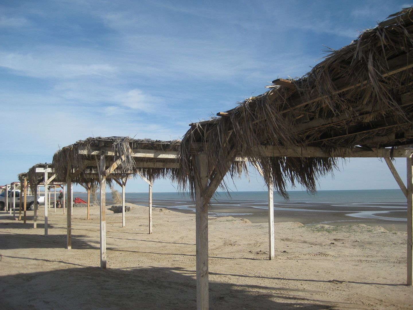
Here is Pete's Camp El Paraiso camping area on the beach (Km. 177.5):
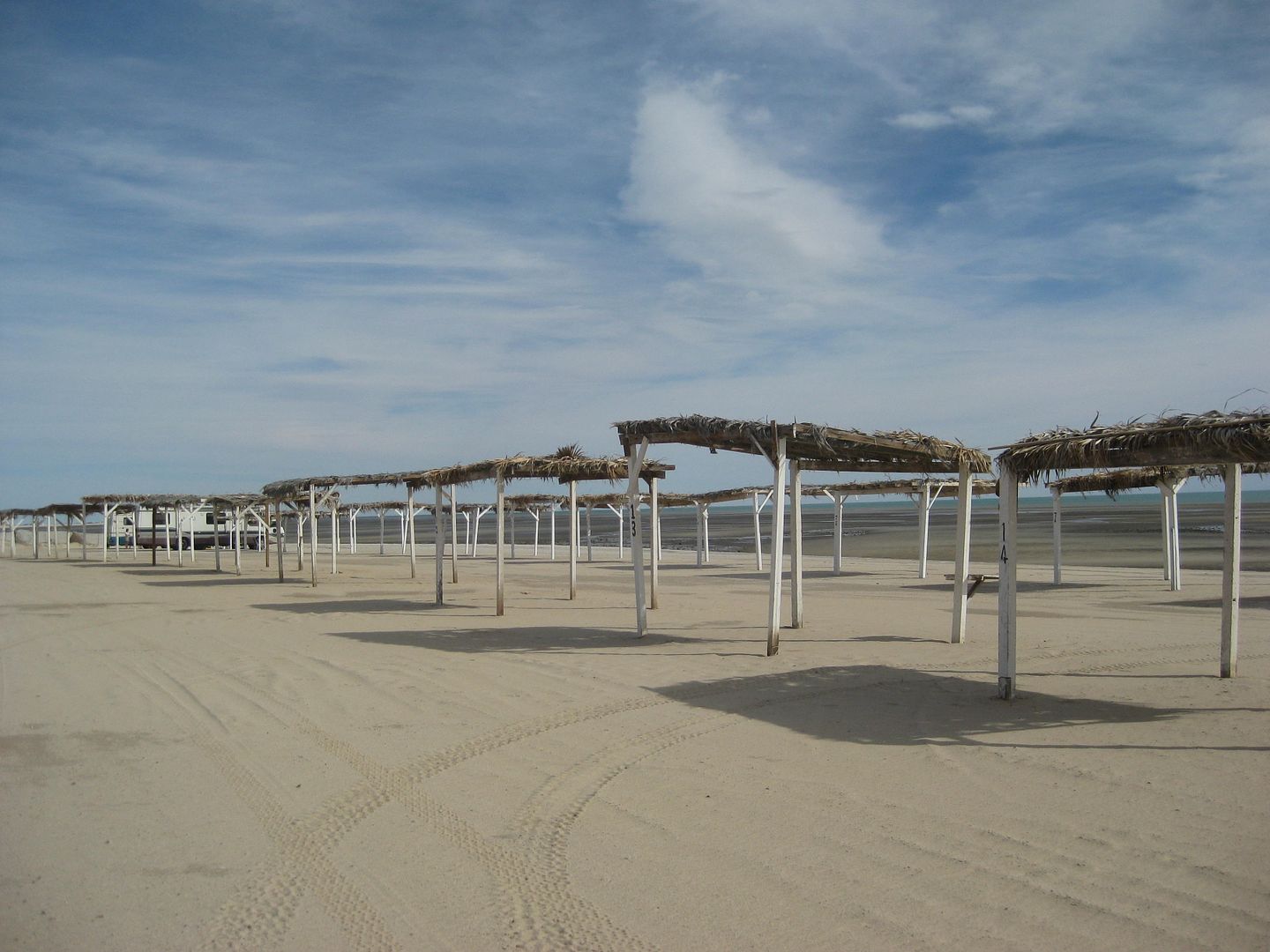
Here is Los Compadres (guessing the former 'Campo Hawaii' at Km. 180+):
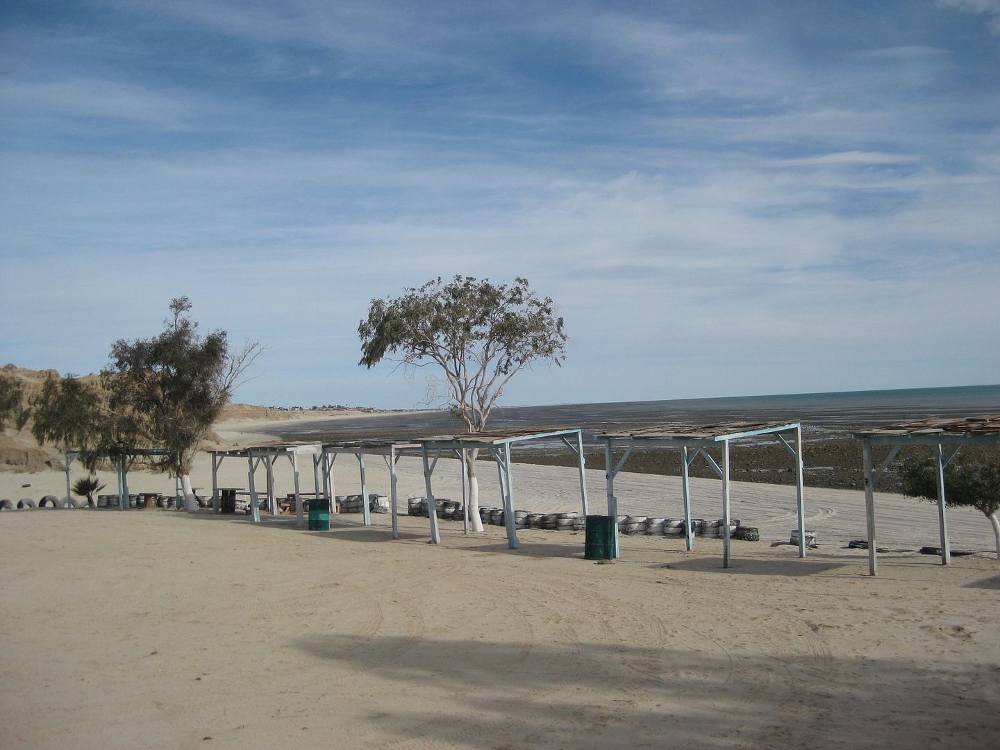
Both are about a mile from the highway.
Here is a third possibility, Playas del Sol (Km. 183).. up on a bluff...
|
|
|
Luna_tik
Newbie
Posts: 4
Registered: 2-21-2018
Member Is Offline
|
|
Oh wow, so much good info, I'm going to have to go back to the drawing board a little as far as location planning is concerned- and that's a good
thing! I was mostly going off of vague recommendations from friends who went years ago, or places that looked interesting on Google maps  Thank you so much everybody! Thank you so much everybody!
Maderita, thank you for the info on insurance, and on Guadalupe Canyon Oasis - that definitely gets added to the list!
PaulW and David K, thanks for the info about Playa Hawaii/ Pete's Camp/ Campo Hawaii/ whatever else it may be called. This is the kind of thing I
wasn't figuring out online, and will really help. The pictures are nice too; looks like just the sort of place I'd like to go!
David K, wow- that is a wealth of information there! I feel like I just got a preview of your guide for free.. I guess that means I'll have to buy it
when it comes out! In the meantime, I'll be sure to check the links and your trip reports. Muchas gracias!
One other thing I meant to put in the OP but forgot; it's apparently whale watching season too. Are there any good places in these areas from which to
spot them, or is it all luck?
~~~~~~~~~~~~~~~~~
Home is wherever you park
|
|
|
Maderita
Senior Nomad
Posts: 638
Registered: 12-14-2008
Location: San Diego
Member Is Offline
|
|
Yes, still gray whale season in the lagoons of the central Pacific coast. Guerrero Negro has the most northerly. Afaik, you will need to sign on with
a tour company to see the whales from pangas (small fishing boats). See Shari's posts on this site.
If you are in La Rumorosa, there is a brief side trip to Vallecitos native-american cave paintings. 1 mile off the toll hwy 2, graded dirt.
Self-guided walking tour, 1 hour loop trail. Secure parking. Minimal cost.
https://en.wikipedia.org/wiki/El_Vallecito
|
|
|
BajaBlanca
Select Nomad
Posts: 13166
Registered: 10-28-2008
Location: La Bocana, BCS
Member Is Offline
|
|
Can I just say that you have asked some really good questions.
I hope you have a blast!
|
|
|
Maderita
Senior Nomad
Posts: 638
Registered: 12-14-2008
Location: San Diego
Member Is Offline
|
|
See Shari's recent posts and photos of friendly encounters with whales:
http://forums.bajanomad.com/search.php?srchuname=shari&s...
http://www.whalemagictours.com/
|
|
|
wilderone
Ultra Nomad
Posts: 3788
Registered: 2-9-2004
Member Is Offline
|
|
Re: "check out Guadalupe"
On your return trip, instead of going through TJ/San Ysidro - which can be daunting and a very long border wait - take Mex. 3 through the Ruta de Vina
and Guadalupe Valley (exit Tecate), passing many wineries, tasting rooms, restaurants. Also, not a toll road. Stop at a couple of the wineries. LA
Cetto is a popular one, they have great olive oil there too. Across the street is Dona Lupe's. They have salsas, jams, wines too of course.
Re: "Mexican Authorities generally ok with car camping on public land or no?" they don't care - you'll be out of sight, remember? Also they hang out
in town and cruise the highways- they won't be where you are. The thing with boondocking is access - you'll see a little road going ... where? Maybe
it's going to someone's ranch, or it gets very sandy and there's no place to turn around. I've found a nice little spot, and a rancher comes driving
up - I'm on his property. "Can I stay?" Of course. So nice. Camp free at El Marmol, Mision San Fernando, Punta Baja - way at the end. Don't
boondock anywhere between El Rosario and San Quintin. A few campgrounds around San Quintin - I like the few spots in front of Cielito Lindo
hotel/restaurant (recent thread on this). There are so many campgrounds south of San Felipe - might as well use them for the bathrooms, beachside
locale.
You'll have a wonderful time. Via con dios.
|
|
|
micah202
Super Nomad
Posts: 1615
Registered: 1-19-2011
Location: vancouver,BC
Member Is Offline
|
|
...I highly recommend the hotsprings just north of Maneandro, not far north for the turnoff to La Buffadora.
Find deets on.... 'the hotsprings thread'. <;~]
|
|
|
| Pages:
1
2 |