| Pages:
1
2 |
David K
Honored Nomad

Posts: 64493
Registered: 8-30-2002
Location: San Diego County
Member Is Offline
Mood: Have Baja Fever
|
|
Quote: Originally posted by micah202  | ...I highly recommend the hotsprings just north of Maneandro, not far north for the turnoff to La Buffadora.
Find deets on.... 'the hotsprings thread'. <;~] |
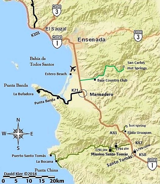
Those are called San Carlos Hot Springs.
|
|
|
HeyMulegeScott
Senior Nomad
Posts: 690
Registered: 8-25-2009
Location: Orygone/Mulege
Member Is Offline
|
|
Some great feedback in this thread. I wouldn't go through Algodones. We were just there yesterday getting our FMM. It's a zoo (mainly a gringo zoo)
with narrow streets. We talked to a European guy with a really cool looking 4x4 camper who said they were making him go back to the US because it was
too big to fit in the streets. We did Mexicali East last year and it was fairly easy to find Hwy 5.
|
|
|
AKgringo
Elite Nomad
Posts: 5819
Registered: 9-20-2014
Location: Anchorage, AK (no mas!)
Member Is Offline
Mood: Retireded
|
|
Another option is crossing at San Luis, just south of Yuma. It was discussed recently here;
http://forums.bajanomad.com/viewthread.php?tid=89485
If you are not living on the edge, you are taking up too much space!
"Could do better if he tried!" Report card comments from most of my grade school teachers. Sadly, still true!
|
|
|
Luna_tik
Newbie
Posts: 4
Registered: 2-21-2018
Member Is Offline
|
|
I'm floored by the friendly welcome, and generosity of info sharing I've found here. If this is indicative of the Baja vibe, I'm going to absolutely
love it there!
Maderita, gracias otra vez for good info, particularly on the whale watching.
BajaBlanca, I like to think I do a good job of preparing before exploration. Thank you for the vote of confidence!
Wilderone, thank you so much for the boondocking advice!
Micah202, I have been following the hotsprings thread with interest, thank you!
Three2tango, I hear ya on that. Not going through Los Algodones for cultural or sight seeing reasons, just because that's where I have a dental
appointment. Onward towards more fun things from there!
One thing I just realized today; apparently I've accidentally timed this trip to coincide with Semana Santa. How much more crowded should I expect the
beaches and hot springs to be?
~~~~~~~~~~~~~~~~~
Home is wherever you park
|
|
|
kevin_in_idaho
Nomad
Posts: 143
Registered: 12-13-2016
Member Is Offline
|
|
First time is always the 'scariest" but it's really pretty easy. If you have fun at checkpoints and just do what they ask, you'll be fine.
Intimiating the first time you see kids with guns stopping you. Normally they look in your cooler, ask if you have any guns or ammo. They might take
a few beers if they see them.
Coming back North, you might head through the wine country up from Ensenada and miss the TJ hassle. Good wine, good prices there too!
Gas is plentiful and if you aren't going off road far and keep track of your range, you don't really need to carry anymore. Don't fill up your extra
cans on the US side though. They may not let you in with them filled. Just fill them up in Baja. Get gas when you can or are about half full but
again there are so many stations down there. Make sure they zero out the pump before pumping. You could put a locked gas cap on so they don't start
pumping before you get out of the truck and check. Get local currency too. ATMs are around.
Have fun.
|
|
|
PaulW
Ultra Nomad
Posts: 3009
Registered: 5-21-2013
Member Is Offline
|
|
David did you ask the caretaker at El Pescador if camping is still allowed in the beach area? Its been to many years since I have been there so I do
not have an update.
Also the other Playa Grande at km 183.4 and is not accessible any more. I mention that because there are two of them.
==========
| Quote: Originally posted by David K | Hi Luna-tik,
Welcome to Nomad!
Everything seems to work out in Baja so try not to stress.
My first time driving myself was when I was 16, in 1974 and haven't stopped since! I have never been robbed or hassled (much). Camping is my main
thing but there are a few choice motels for clean up or when it isn't convenient to set up a tent.
As TMW posted, I did 7 trips in 2017 to try and cover as much of Baja's best for a new Guide. The trip reports are in the Nomad Trip Reports forum and
numbered TRIP # 1-7, plus a family camping trip to Shell Island on Memorial Day. Shell Island is a beautiful barrier island beach, but requires 4WD
(and low tide) to get to!
My 2018 maps of Baja (for the future guide) are posted in the Nomad Road Conditions forum. They are designed to illustrate places and roads mentioned
in the guide.
That all being said, you are getting good advice here. It does sound like you have been working on a route. Here are my comments on the first couple
places you mentioned, for what that's worth:
Playa Hawaii. I think is an old name and is now Los Compadres?
The campos that are primarily for camping, north of San Felipe, are mentioned in my guide (along with gas stations, a restaurant, and motels:
Km. 171.5 Villas Cortez, 2.4 miles. Camping, pool, and palapas. No vehicle parking near the palapas.
Km. 173.5 Playa Grande, 1.9 miles. Palapa camping.
Km. 177.5 Pete’s Camp El Paraiso, 1 mile to the restaurant and 1.1 miles to the beach with palapa camping. http://petescamp.com/
Km. 178.5+ Pemex gas station, west side.
Km. 179 Playa del Oro, a private home development. The Road Runner Restaurant and Deli is at the entrance, excellent food.
Km. 180+ Campo Los Compadres, 0.9 mile. Palapa camping. https://www.facebook.com/Campo-los-Compadres-136752236414823...
Km. 181 Colonia Morelia road (signed 60 kms.). New paved surface ends soon on this road west to Valle Chico and Diablo Dry Lake.
Km. 181.5+ Pai Pai Campo, 0.9 mile. Beach and camping, no palapas or services.
Km. 182 Hotel Sky Blue on the west side of the highway.
Km. 183 Playas del Sol, 1.1 mile. Camping palapas. https://www.facebook.com/delsolsanfelipe/
Km. 184 Pemex gas station, west side.
Km. 184+ Campo El Pescador road.
Km. 185.5 Hotel Diamante on the west side of the highway (Single room 480 pesos).
The highway soon makes a long, sweeping curve to the east.
------------------------------------------------------------------------------------------------------------------------
Puerticitos Hot Springs It is spelled Puertecitos. Here is what I have for that area:
Km. 74.5 Puertecitos paved entrance road.
0.2 mile to Octavio’s Playa Escondida driveway (additional 0.3 mile to the camp). Beach palapa camping.
0.7-mile Puertecitos Pemex gas station.
Go left just ahead by the restaurant. A charge of 200 pesos/vehicle is collected to enter Puertecitos property beyond here.
0.9 mile to the beach palapas. Palapa camping only, no cabins or rooms.
1.2 miles to the hot springs. The natural lava-rock bathing pools mix sea water with hot sulfur springs to determine bathing temperature. The pools
can be too hot at low tide and completely underwater at high tide.
1.3 miles to a boat-launching ramp at the end of the road at the point.
-------------------------------------------------------------------------------------------------------------------------
As for the others, see my trip reports, but in short...
San Luis Gonzaga Bay... a great place, not tons there yet besides private homes and a gas station/ market. Papa
Fernandez' has good food and beach camping over the hill. Alfonsina's has the bar and hotel. Camp Beluga
has palapas for camping. El Sacrificio has cabins. Punta Final has a camping area. 5 miles north of Papa Fernandez'
on the bay is Punta Bufeo, with a small motel and a mile north of it is La Poma with good food.
Cataviña is a unique area with the boulders and boojum trees... well all of central Baja really is!
El Rosario is farm town but with several good, casual eating places and perhaps the best motel in Baja (Baja Cactus, next to the
Pemex station). There are many sites in the area, but without 4WD, it may not be wise to do too much sightseeing.
La Lobera... sea lions are not always there but the 'hole' (visible on Google Earth) is neat to see. My last time driving in the road
was pretty rough and very dusty. The sea-culture facility that built the road and viewing area for the hole went out of business in 2015 so the road
wasn't maintained after that.
Camalu is a farming center... I have not been to the coast directly west of there, but not far away, at San Jacinto (shipwreck and a
few miles north to near Cuatro Casas).
Ensenada is a big city. I am not into cities.
I suggest north from Ensenada you take Hwy. 3 to Tecate and cross the border there!!! The drive is nice, free, and the smaller Tecate
border is great if you cross back in the middle of the week (there are only 2 gates).
[Edited on 2-24-2018 by David K] |
|
|
|
David K
Honored Nomad
Posts: 64493
Registered: 8-30-2002
Location: San Diego County
Member Is Offline
Mood: Have Baja Fever
|
|
Hi Paul,
Notice that I simply labeled Km. 184+ as "Campo El Pescador Road" as there was a chain crossed it and when I parked there to take notes, nobody
appeared from the nearby trailer.
On future trips, I can add to the road guide database for future editions or live online updates.
There are some other campos just north of San Felipe in addition to that one that I would like to check out.
The three primary camping campos north of town are on my San Felipe Area map:

[Edited on 2-26-2018 by David K]
|
|
|
PaulW
Ultra Nomad
Posts: 3009
Registered: 5-21-2013
Member Is Offline
|
|
David, I have been slowly logging the campos and other beach places. I will update you after a few more trips. Like you do it takes time to log the Km
and coords and drive to the beach when possible. One of the issues is finding some one to tell me the place names - Ha.
Lots of privately owned parcels that all have roads to the beach area.
|
|
|
David K
Honored Nomad
Posts: 64493
Registered: 8-30-2002
Location: San Diego County
Member Is Offline
Mood: Have Baja Fever
|
|
| Quote: Originally posted by PaulW | David, I have been slowly logging the campos and other beach places. I will update you after a few more trips. Like you do it takes time to log the Km
and coords and drive to the beach when possible. One of the issues is finding some one to tell me the place names - Ha.
Lots of privately owned parcels that all have roads to the beach area. |
Yes, it is a fun job but often needs more than a single trip to get all the data. I need to drive north from downtown to the old camps past the ice
plant where they slid blocks into the shrimp boats at high tide (is that still an ice plant?). Then beyond to the former Ensenada Blanco (now Cantu's
Cove). Somebody just did a post on it: http://forums.bajanomad.com/viewthread.php?tid=89136
|
|
|
wilderone
Ultra Nomad
Posts: 3779
Registered: 2-9-2004
Member Is Offline
|
|
"Semana Santa. How much more crowded should I expect the beaches and hot springs to be?"
Some places like Conception Bay will be 3 rows deep. San Carlos hotsprings will probably be crowded, but OK if you just want to stay a couple hours
and not overnight there.
|
|
|
| Pages:
1
2 |


