| Pages:
1
2
3
4 |
David K
Honored Nomad

Posts: 64476
Registered: 8-30-2002
Location: San Diego County
Member Is Offline
Mood: Have Baja Fever
|
|
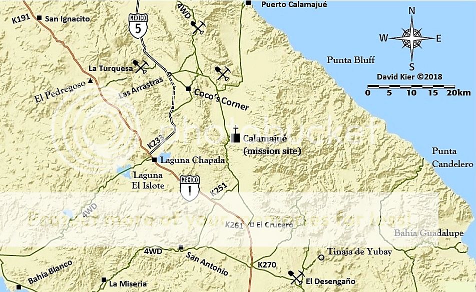
Old Maps are a look back in time... they help to make new discoveries!
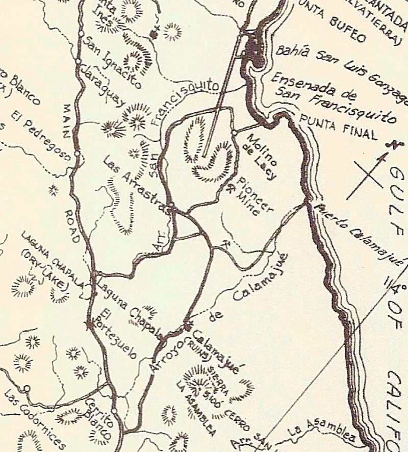
Howard Gulick (1962 Lower California Guidebook) map of the area of discussion.
1970 Cliff Cross Maps:
Note: Mission Calamajué incorrectly located.
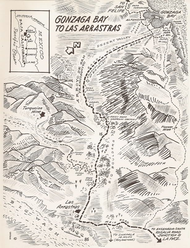
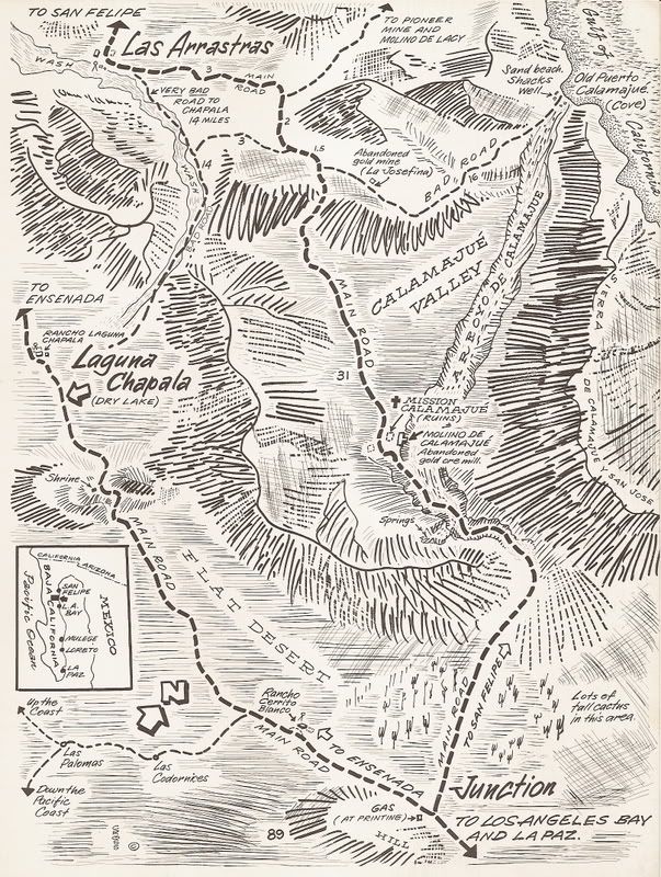
1975 Baja California Guidebook map (Wheelock & Gulick):
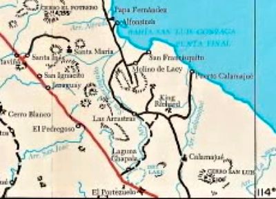
2010 AAA Map, same region:
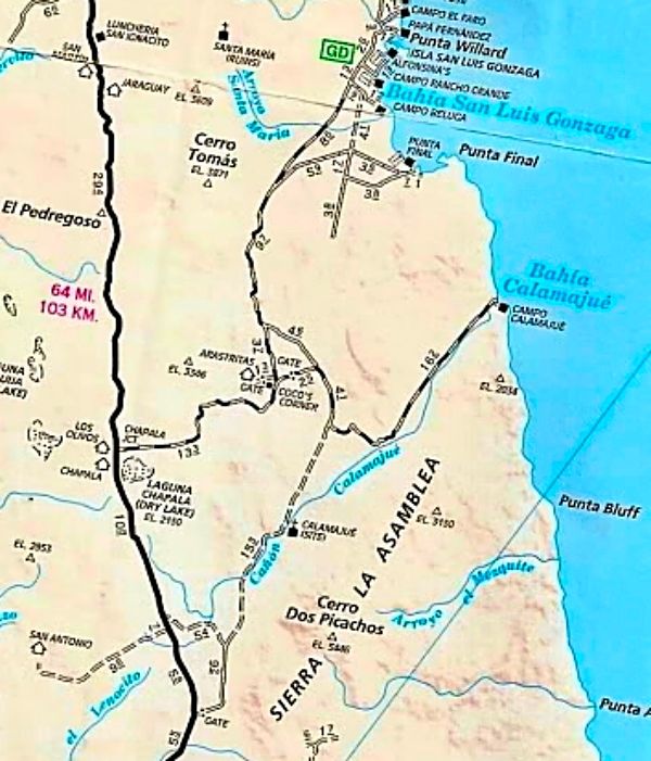
Now, 2018:

[Edited on 3-23-2018 by David K]
|
|
|
PaulW
Ultra Nomad
Posts: 3004
Registered: 5-21-2013
Member Is Offline
|
|
Pioneer mine trail GPS file update
I have revised the GPS file to add the WPs that all the contributors provided. The basic track is unchanged.
Please use your tool to create a .KML or .GPX file from the attached .USR file.
Attachment: Pioneer Mine Rd WPs.usr (80kB)
This file has been downloaded 337 times
|
|
|
JZ
Elite Nomad
Posts: 9215
Registered: 10-3-2003
Member Is Offline
|
|
Quote: Originally posted by PaulW  | I have revised the GPS file to add the WPs that all the contributors provided. The basic track is unchanged.
Please use your tool to create a .KML or .GPX file from the attached .USR file. |
It would be helpful to all if you converted .usr files to .gpx or .kml.
|
|
|
PaulW
Ultra Nomad
Posts: 3004
Registered: 5-21-2013
Member Is Offline
|
|
Sorry about that.
GPX files are way to big for attachments
Compare 80kB for USR and 657kB for GPX which is above the Nomad limit of 250kB
|
|
|
TMW
Select Nomad
Posts: 10659
Registered: 9-1-2003
Location: Bakersfield, CA
Member Is Offline
|
|
JZ the conversion is easy at http://www.gpsvisualizer.com/
|
|
|
JZ
Elite Nomad
Posts: 9215
Registered: 10-3-2003
Member Is Offline
|
|
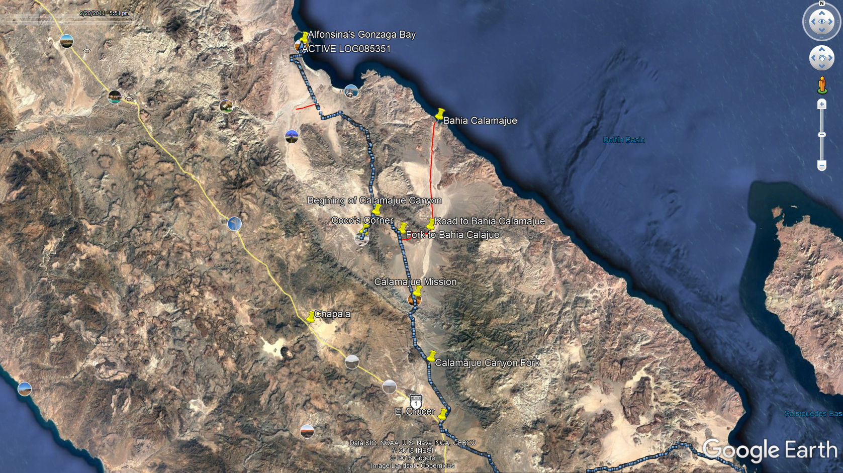
We are going to ride it in the next two weeks. Been planning it out on GE. We'll swing out to Bahia Calamajue after riding through.
[Edited on 3-25-2018 by JZ]
|
|
|
JZ
Elite Nomad
Posts: 9215
Registered: 10-3-2003
Member Is Offline
|
|
Yeah, I hear ya. But then everyone has to convert it.
I have the route, just giving a suggestion for others.
|
|
|
4x4abc
Ultra Nomad
Posts: 4163
Registered: 4-24-2009
Location: La Paz, BCS
Member Is Offline
Mood: happy - always
|
|
I hate those usr files
GPSBabel does not translate them correctly
actually I hate it even more that every GPS manufacturer has to have their own software
so, moving data in the field from one machine to the other is usually impossible
Harald Pietschmann
|
|
|
PaulW
Ultra Nomad
Posts: 3004
Registered: 5-21-2013
Member Is Offline
|
|
Bable does have an issue.
I now use Trackmaker with success.
Tom uses http://www.gpsvisualizer.com/ with success.
The Lowrance Gen3 usr files are a problem due to the new format the some conversion SW have not adapted to.
|
|
|
TMW
Select Nomad
Posts: 10659
Registered: 9-1-2003
Location: Bakersfield, CA
Member Is Offline
|
|
I don't use usr files since all my devices are Garmin so I use gpx files. Paul can correct me but most off road racers use usr files since most have
Lowrance GPS units. In the beginning they were marine fish finding systems converted to off road use since they had big screens. I haven't looked into
todays race cars/trucks for the past couple of years to see what is being used.
|
|
|
JZ
Elite Nomad
Posts: 9215
Registered: 10-3-2003
Member Is Offline
|
|
Broken record here, but this is another huge reason to use a GPS app on your smartphone.
Back Country Navigator emails you a .gpx file of your track.
Ppl, throw your out-dated standalone GPS systems in the trash (or sell them on craigslist) and get a good phone!
[Edited on 3-25-2018 by JZ]
|
|
|
TMW
Select Nomad
Posts: 10659
Registered: 9-1-2003
Location: Bakersfield, CA
Member Is Offline
|
|
Smart phone are too expensive for me. I'm just a poor investor living on a pension.
|
|
|
willardguy
Elite Nomad
Posts: 6451
Registered: 9-19-2009
Member Is Offline
|
|
what did you folks do before your electronic umbilical cord....have an adventure?
|
|
|
David K
Honored Nomad
Posts: 64476
Registered: 8-30-2002
Location: San Diego County
Member Is Offline
Mood: Have Baja Fever
|
|
It is just one road, no choices once you leave Molino de Lacy.
|
|
|
PaulW
Ultra Nomad
Posts: 3004
Registered: 5-21-2013
Member Is Offline
|
|
I have mentioned it before that I am using a low price Andriod tablet, woks ok with some drawbacks. Most of them use Garmin format.
As mentioned there are many gps apps for both phones and tablets. Yes I do send GPX files via email. Just ask via U2U with an email address. The
conversion take less than a minute.
The answer to Tom's question is that the serious racers are most all using the large screen Lowrance GPSs (fish finder with stuff like radar and
sonar disabled). They are still the best, but way to expensive for me. I have several small older ones and they do not get used much. They are very
hard to find used on the web. Figure the small Lowrance (5") sold new for double the cost of a Nuvi,but the Lowrance units are full featured to make
trails and import and export via SD card.
|
|
|
PaulW
Ultra Nomad
Posts: 3004
Registered: 5-21-2013
Member Is Offline
|
|
Here is a screen shot for most of the trip.
==== =
| Quote: Originally posted by PaulW | I have revised the GPS file to add the WPs that all the contributors provided. The basic track is unchanged.
Please use your tool to create a .KML or .GPX file from the attached .USR file. |

|
|
|
David K
Honored Nomad
Posts: 64476
Registered: 8-30-2002
Location: San Diego County
Member Is Offline
Mood: Have Baja Fever
|
|
'Yubay' on that map is incorrect, just fyi. 
|
|
|
Ken Cooke
Elite Nomad
Posts: 8921
Registered: 2-9-2004
Location: Riverside, CA
Member Is Offline
Mood: Black Trans Lives Matter
|
|
10 or 11 years ago on my Baja Grande run, I remember traveling near this route, but it was a mild dirt road with a muddy crossing. No rocks, but lots
of dirt roads that we encountered.
|
|
|
JZ
Elite Nomad
Posts: 9215
Registered: 10-3-2003
Member Is Offline
|
|
| Quote: Originally posted by Ken Cooke | | 10 or 11 years ago on my Baja Grande run, I remember traveling near this route, but it was a mild dirt road with a muddy crossing. No rocks, but lots
of dirt roads that we encountered. |
We just went to ride it in April. Got a few miles in before my kid's bike had a problem and we decided to turn back. I can confirm it is rocky as
hell.
|
|
|
JZ
Elite Nomad
Posts: 9215
Registered: 10-3-2003
Member Is Offline
|
|
| Quote: Originally posted by PaulW | I have mentioned it before that I am using a low price Andriod tablet, woks ok with some drawbacks. Most of them use Garmin format.
As mentioned there are many gps apps for both phones and tablets. Yes I do send GPX files via email. Just ask via U2U with an email address. The
conversion take less than a minute.
The answer to Tom's question is that the serious racers are most all using the large screen Lowrance GPSs (fish finder with stuff like radar and
sonar disabled). They are still the best, but way to expensive for me. I have several small older ones and they do not get used much. They are very
hard to find used on the web. Figure the small Lowrance (5") sold new for double the cost of a Nuvi,but the Lowrance units are full featured to make
trails and import and export via SD card. |
Trust me on this one. If you have an Android tablet you want to be running Back Country Navigator on it. Way better than anything else, including a
Lowarance GPS. I've owned all the standalone GPSs. They are all garbage now compared to a good phone or tablet app. No messy conversions necessary.
If you are on the water, you should be using Navionics on your phone or tablet. Crushes all standalone marine GPSs. I haven't used my built in dash
mounted GPS with radar in years.
Google Earth + Back Country Navigator is the ta taas for navigation.
[Edited on 7-16-2018 by JZ]
|
|
|
| Pages:
1
2
3
4 |


