| Pages:
1
2
3
..
9 |
PaulW
Ultra Nomad

Posts: 3113
Registered: 5-21-2013
Member Is Offline
|
|
Canyons
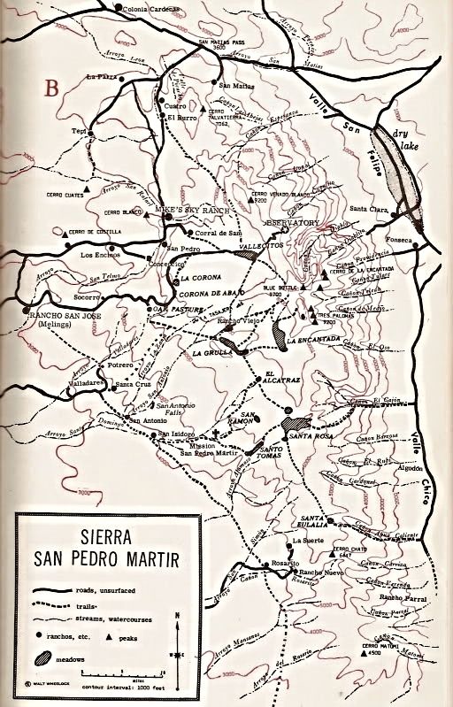
Can anyone update the results of my study?
See the asterisk for questionable locations or names.
My study of canyons on the east side of San Pedro Martir. A work in progress
The order of the images start from the north


|
|
|
mtgoat666
Platinum Nomad
Posts: 21147
Registered: 9-16-2006
Location: San Diego
Member Is Offline
Mood: Hot n spicy
|
|
For names of canyons, and some old (and outdated) trail info, Look at robinson’s Book. Also schaad map and inegi topos.
Woke!
Hands off!
“Por el bien de todos, primero los pobres.”
“...ask not what your country can do for you – ask what you can do for your country.” “My fellow citizens of the world: ask not what America
will do for you, but what together we can do for the freedom of man.”
Pronoun: the royal we
|
|
|
PaulW
Ultra Nomad
Posts: 3113
Registered: 5-21-2013
Member Is Offline
|
|
Those source have been used, including the Barber book. I have pretty much use all my ref material. Got most of the canyon locations from INEGI. Not
easy to follow the drainage's from whee the darn things are labeled.
|
|
|
4x4abc
Ultra Nomad
Posts: 4456
Registered: 4-24-2009
Location: La Paz, BCS
Member Is Offline
Mood: happy - always
|
|
http://www.beta.inegi.org.mx/app/biblioteca/ficha.html?upc=7...
http://www.beta.inegi.org.mx/app/biblioteca/ficha.html?upc=7...
http://baja101.com/BCTC/northone.html
Harald Pietschmann
|
|
|
mtgoat666
Platinum Nomad
Posts: 21147
Registered: 9-16-2006
Location: San Diego
Member Is Offline
Mood: Hot n spicy
|
|
Quote: Originally posted by PaulW  | | Those source have been used, including the Barber book. I have pretty much use all my ref material. Got most of the canyon locations from INEGI. Not
easy to follow the drainage's from whee the darn things are labeled. |
At the south end of SPM there is one canyon with a stock trail that has seen use recently (past decade), but probably abandoned by now, not sure if
anyone runs stock or horses up that canyon anymore....
I think the only canyon frequently traveled is diablo, and then only by hikers bush-whacking,... would be fun to see a group volunteer to cut brush
and keep the trail open,... it’s a good hike as it has reliable water, and if it were less bush-whacking it would be more attractive for hikers,...
there are some other canyons that would make great hikes, but again, they are choked with brush so a bit of an ordeal to hike and scramble.
Woke!
Hands off!
“Por el bien de todos, primero los pobres.”
“...ask not what your country can do for you – ask what you can do for your country.” “My fellow citizens of the world: ask not what America
will do for you, but what together we can do for the freedom of man.”
Pronoun: the royal we
|
|
|
PaulW
Ultra Nomad
Posts: 3113
Registered: 5-21-2013
Member Is Offline
|
|
Goat,
That stock trail was used by Melling goes down the mountain to the Auga Caliente canyon entrance. And yes the trail is very overgrown. I have not
heard of anyone going up that trail - just stories from the old days. Recently access to that canyon has not been allowed by the ranch owner of land
at the entrance to the canyon.
|
|
|
PaulW
Ultra Nomad
Posts: 3113
Registered: 5-21-2013
Member Is Offline
|
|
Harald,
Thanks for the links, but I have all the maps I need that were previously downloaded.
For sure I kept and printed the Key on the last link.
|
|
|
David K
Honored Nomad
Posts: 65581
Registered: 8-30-2002
Location: San Diego County
Member Is Offline
Mood: Have Baja Fever
|
|
| Quote: Originally posted by PaulW | Goat,
That stock trail was used by Melling goes down the mountain to the Auga Caliente canyon entrance. And yes the trail is very overgrown. I have not
heard of anyone going up that trail - just stories from the old days. Recently access to that canyon has not been allowed by the ranch owner of land
at the entrance to the canyon. |
El Cajon Canyon was mentioned in the Meling Ranch history book.
|
|
|
PaulW
Ultra Nomad
Posts: 3113
Registered: 5-21-2013
Member Is Offline
|
|
I was recently told the the Melling cowboys have been to the upper reaches of El Cajon and Agua Caliente during the roundup where they try to locate
all the free spirit cattle.
Compared to Agua Caliente El Cajon is a more difficult hike. It is very overgrown above the waterfall.
[Edited on 3-25-2018 by PaulW]
|
|
|
David K
Honored Nomad
Posts: 65581
Registered: 8-30-2002
Location: San Diego County
Member Is Offline
Mood: Have Baja Fever
|
|
Did you ever meet the gringo Bob ('burro bob') who lived at the ranch house at the El Cajon canyon entrance? He used to post here about hiking up to
the top of the mountain. It was a regular trail used by the Dominicans and Indians of Mission San Pedro Mártir.
Update: 'burro bob' was a heavy contributor here from June 2004 until Oct. 9, 2007, then just vanished from Nomad with no warning.
[Edited on 3-26-2018 by David K]
|
|
|
David K
Honored Nomad
Posts: 65581
Registered: 8-30-2002
Location: San Diego County
Member Is Offline
Mood: Have Baja Fever
|
|
The first map with many canyons named was from 'Camping and Climbing in Baja' c1967 This was a revised map showing the new Observatory, the road
there, and Mike's Sky Rancho... 1972 edition, I believe:
[Edited on 3-26-2018 by David K]
|
|
|
David K
Honored Nomad
Posts: 65581
Registered: 8-30-2002
Location: San Diego County
Member Is Offline
Mood: Have Baja Fever
|
|
Bruce Barber Names the Canyons:
From Bruce's great book:
Of Sand and Sea...
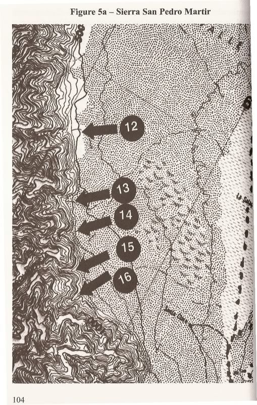
12) Esperanza
13) Copal
14) Copalito
15) Diablo
16) Diablito
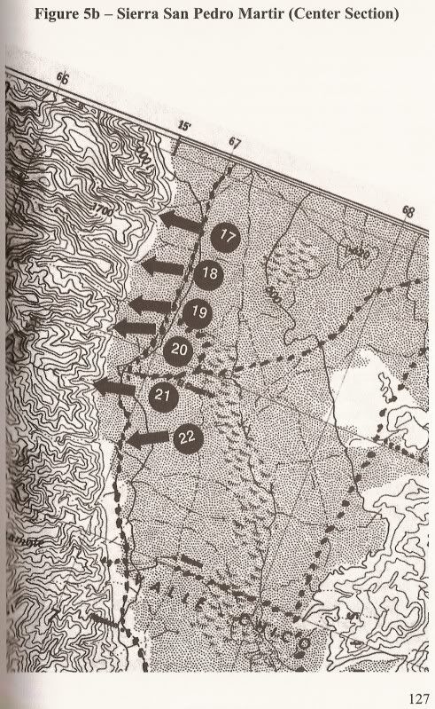
17) Providencia
18) Teledo
19) En Medio
20) Oso
21) Cajon
22) Barroso
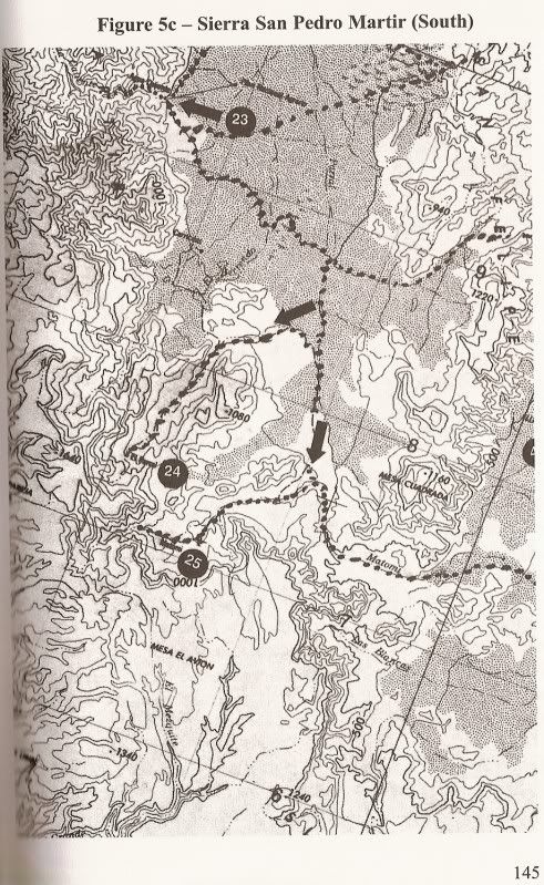
23) Agua Caliente
24) Parral
25) Matomi
|
|
|
PaulW
Ultra Nomad
Posts: 3113
Registered: 5-21-2013
Member Is Offline
|
|
Comparison list

|
|
|
PaulW
Ultra Nomad
Posts: 3113
Registered: 5-21-2013
Member Is Offline
|
|
| Quote: Originally posted by David K | Did you ever meet the gringo Bob ('burro bob') who lived at the ranch house at the El Cajon canyon entrance? He used to post here about hiking up to
the top of the mountain. It was a regular trail used by the Dominicans and Indians of Mission San Pedro Mártir.
Update: 'burro bob' was a heavy contributor here from June 2004 until Oct. 9, 2007, then just vanished from Nomad with no warning.
[Edited on 3-26-2018 by David K] |
==== =
Not 'Burro Bob', but Rob K. who has property nearby. Rob does not live there but lives closer to town in the Ejido hosing area.
|
|
|
LukeJobbins
Nomad
Posts: 196
Registered: 3-11-2014
Location: Lemoore, Ca
Member Is Offline
|
|
I personally have not done the desert route up the devils canyon but it is hiked pretty frequently. I would guess 2 weekends at least out of every
month. Sofia and I both want to do two different canyons up to picacho and Sofia wants to do all 7 routes up to picacho and write a book about them.
|
|
|
PaulW
Ultra Nomad
Posts: 3113
Registered: 5-21-2013
Member Is Offline
|
|
| Quote: Originally posted by LukeJobbins | | I personally have not done the desert route up the devils canyon but it is hiked pretty frequently. I would guess 2 weekends at least out of every
month. Sofia and I both want to do two different canyons up to picacho and Sofia wants to do all 7 routes up to picacho and write a book about them.
|
= ==
Two routes is a big deal.
7 routes would be really hard core. I have only read about 3 maybe 4 routes with success. Providencia is definitely an aid climb from my reading.
East approach can be dicey at the pendulum and/or the second pitch, but at times I have done both with no personal aids. Just used the old existing
cable for the pendulum. With a full pack it gets to be a problem. I used a haul rope for the pack.
|
|
|
David K
Honored Nomad
Posts: 65581
Registered: 8-30-2002
Location: San Diego County
Member Is Offline
Mood: Have Baja Fever
|
|
In reviewing older threads here on Nomad about Diablo and the canyons, etc. I read that the El Cajon Canyon Trail to the top was totally destroyed by
one of the big storms.
Here it is from bajalou, in 2008:
Local Mexican friends have told me that the trail in Canon Cajon that had been used for many years was washed out and away by Hurricane Nora in 97. He
said it is now impossible to traverse the canyon without some serious mountain climbing equipment and skills.
|
|
|
PaulW
Ultra Nomad
Posts: 3113
Registered: 5-21-2013
Member Is Offline
|
|
My last trip ended at the waterfall where the bushes became to dense to pass. Previously a year ago, I got to the old rock wall dam above the
waterfall with difficulty. No sign of any kind of trail. Maybe further up?
One can drive thru the corral to the pila and park and walk the short distance to the water flowing over the rock (waterfall).
|
|
|
PaulW
Ultra Nomad
Posts: 3113
Registered: 5-21-2013
Member Is Offline
|
|
Update
I have not seen Rob K. ('burro bob') for some time. I will try to look him up. He helped me on a SCORE marking trip and gave me some help for
Provedencia canyon when we were planning to do the climb. In time that all that all fell through. At our last contact he said he was still getting a
stipend when the races pass through his property. Last time I saw him he was living in SF in the ejido with his elderly mother.
== ==
| Quote: Originally posted by David K | Did you ever meet the gringo Bob ('burro bob') who lived at the ranch house at the El Cajon canyon entrance? He used to post here about hiking up to
the top of the mountain. It was a regular trail used by the Dominicans and Indians of Mission San Pedro Mártir.
Update: 'burro bob' was a heavy contributor here from June 2004 until Oct. 9, 2007, then just vanished from Nomad with no warning.
[Edited on 3-26-2018 by David K] |
|
|
|
4x4abc
Ultra Nomad
Posts: 4456
Registered: 4-24-2009
Location: La Paz, BCS
Member Is Offline
Mood: happy - always
|
|
will post the canyons later today
Harald Pietschmann
|
|
|
| Pages:
1
2
3
..
9 |


