| Pages:
1
2
3
4
5
6
..
9 |
PaulW
Ultra Nomad

Posts: 3008
Registered: 5-21-2013
Member Is Offline
|
|
Yes, I have downloaded all the images that Schad had on his brochure and originally on his web site.
Pretty old but he sure had very good topo detailed map back then.
My image detail is like your post.
If you don’t have the complete images from his climbing brochure, I can forward them to you.
|
|
|
geoffff
Senior Nomad
Posts: 643
Registered: 1-15-2009
Member Is Offline
|
|
Quote: Originally posted by PaulW  | Yes, I have downloaded all the images that Schad had on his brochure and originally on his web site.
Pretty old but he sure had very good topo detailed map back then.
My image detail is like your post.
If you don’t have the complete images from his climbing brochure, I can forward them to you.
|
I would love that, thanks!
|
|
|
geoffff
Senior Nomad
Posts: 643
Registered: 1-15-2009
Member Is Offline
|
|
My attempt earlier to make a visual map of PaulW's canyon naming seems to not have the canyon names line up with Schad's map for Providencia, Toledo,
En Medio, Oso.
Am I incorrect, or is Schad?

|
|
|
geoffff
Senior Nomad
Posts: 643
Registered: 1-15-2009
Member Is Offline
|
|
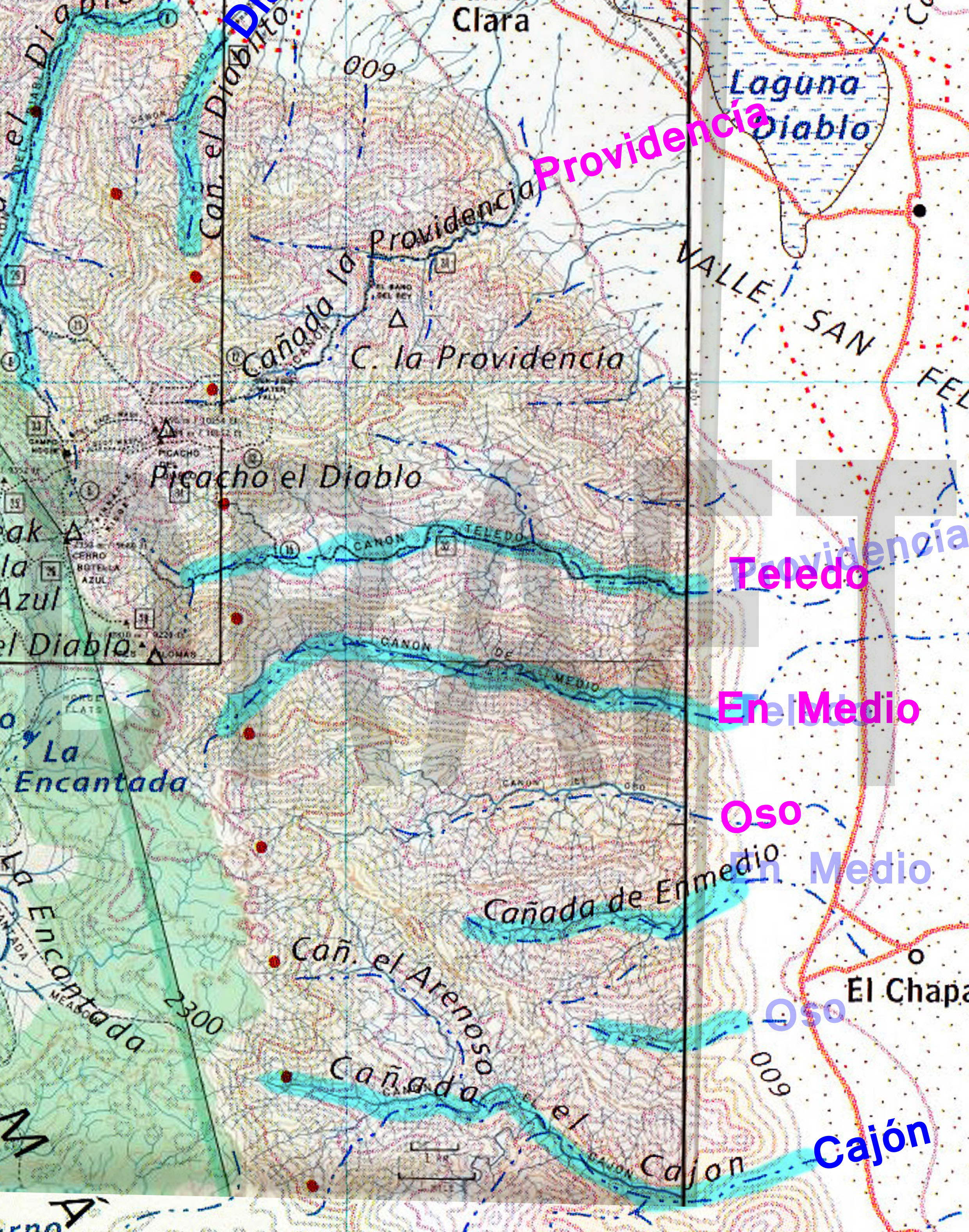
I suspect I didn't follow your descriptions well for these canyons. How about these corrections (in Magenta) if I follow Schad's map? (Overlay also
shows Baja Alamanc.)
[Edited on 11-22-2021 by geoffff]
|
|
|
geoffff
Senior Nomad
Posts: 643
Registered: 1-15-2009
Member Is Offline
|
|
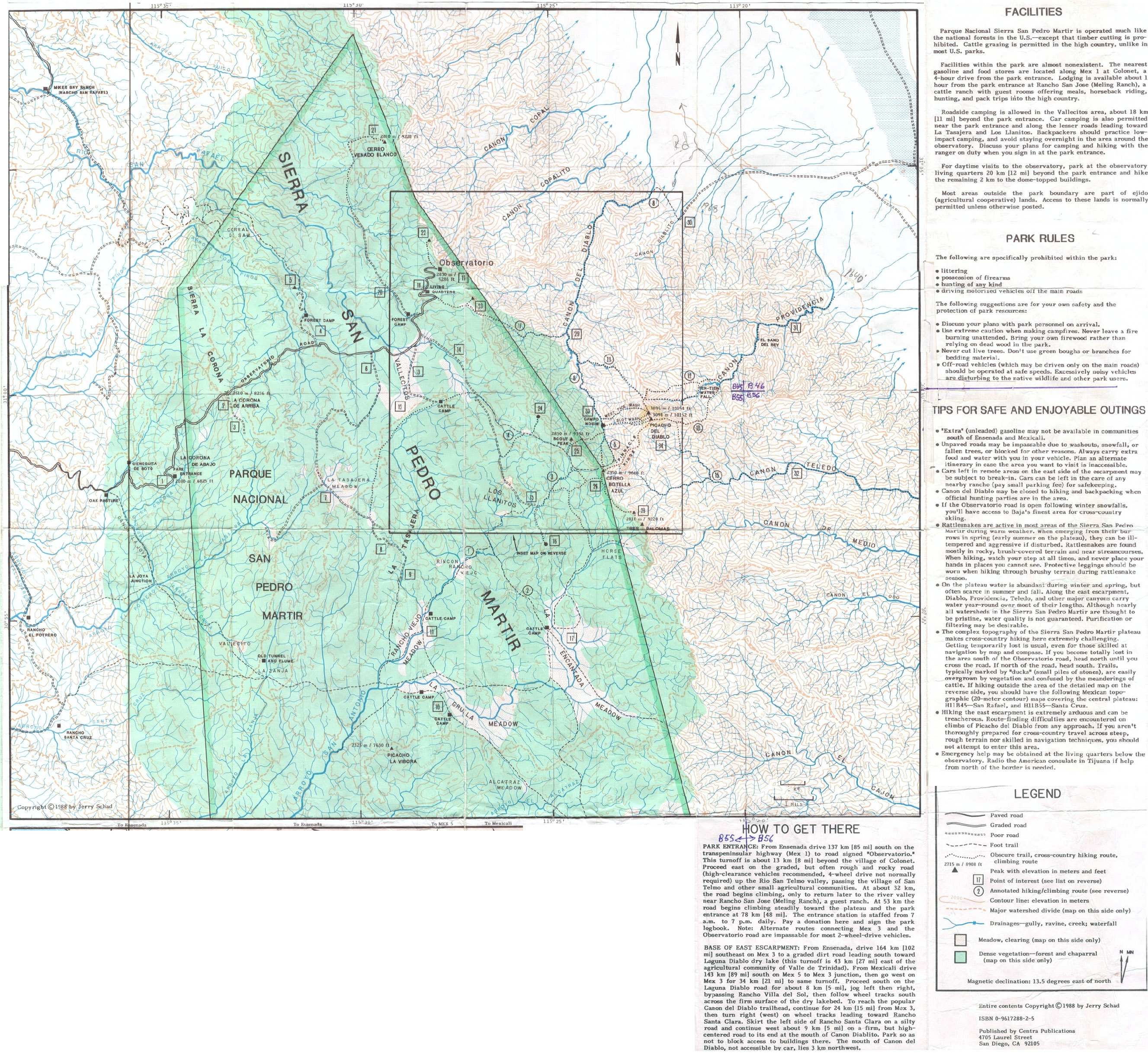
PaulW was kind to share with me his scans of the Jerry Schad maps of the Picacho del Diablo area. I (mostly) stitched them back together. Click links
or images to open full size:

1988--Picacho-Del-Diablo--Jerry-Schad-Map--Baja-California--Front.jpg
1988--Picacho-Del-Diablo--Jerry-Schad-Map--Baja-California--Back.jpg
|
|
|
PaulW
Ultra Nomad
Posts: 3008
Registered: 5-21-2013
Member Is Offline
|
|
Yes, Now you have the map correct with the Magenta labels
== ===
| Quote: Originally posted by geoffff | I suspect I didn't follow your descriptions well for these canyons. How about these corrections (in Magenta) if I follow Schad's map? (Overlay also
shows Baja Alamanc.)
[Edited on 11-22-2021 by geoffff] |
|
|
|
PaulW
Ultra Nomad
Posts: 3008
Registered: 5-21-2013
Member Is Offline
|
|
The pencil notes on Schad’s Brochure were made Summer 1999 and my climb was made March 11-16 2000
My first article was https://climber.org/reports/2000/651.html
The Nomads post was http://forums.bajanomad.com/viewthread.php?tid=67441#pid8316...
Found the source for Schad’s 1988 map http://dankat.com/swhikes/maps/devil.htm
=== ==
|
|
|
geoffff
Senior Nomad
Posts: 643
Registered: 1-15-2009
Member Is Offline
|
|
Wow! I did come across your climbing web page, but didn't put 2 and 2 together that you were the same PaulW!
|
|
|
geoffff
Senior Nomad
Posts: 643
Registered: 1-15-2009
Member Is Offline
|
|
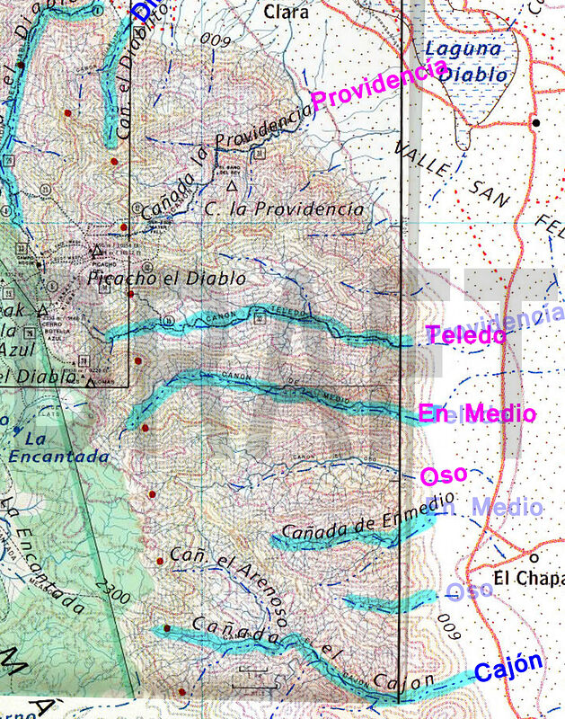
OK, here is my latest canyon map.
The only canyon that still worries me is "En Medio". The Jerry Schad map (& Bruce Barber, and Robinson) show EnMedio where PaulW indicates.
Other resources (INEGI, Baja Almanac, Benchmark) indicate it as being just south of Oso, rather than just north of it. But PaulW's canyon is a more
significant canyon than the INEGI one.
Canoas
Burros
Esperanza: INEGI has the text just south of here
Copal
Copalito: INEGI and Baja Almanac mark a small canyon just south of Copal as "Copalito". INEGI marks this canyon as both
"Diablito" and "Diablo".
Diablo: INEGI marks this canyon as a 2nd occurrence of "Providencia"
Diablito
Providencia
Teledo
En Medio: INEGI, Baja Almanac, Benchmark show this name at different location -- just south of Oso
Oso
El Medio: this is where INEGI, Baja Almanac, Benchmark have it
Novillo: INEGI and Benchmark both show a 2nd Novillo here.
Cajon
Barroso
Novillo
Rubi
Gringa
Agua Caliente
Carrizo
Berrendo
Parral
Matomi
[Edited on 11-23-2021 by geoffff]
|
|
|
geoffff
Senior Nomad
Posts: 643
Registered: 1-15-2009
Member Is Offline
|
|

|
|
|
PaulW
Ultra Nomad
Posts: 3008
Registered: 5-21-2013
Member Is Offline
|
|
Canyon location Conflicts
Examining the list it is clear that the consensus are following Robinson’s list.
My research indicates Barber was the lead to establish the consensus. However, locating a canyon with a name is hit and miss. INEGI is the only
current source, and they have plenty of errors. My latest list identifies all the canyons that have been named. Sure, would be good if we could locate
maps like INEGI that are older than Robinson’s 1967 version. Using the INEGI site, the oldest maps are series 1 dated 1974. Barber had very old
INEGI maps. He gave them away, but the new owner cannot be located.
Geofff pointed out the disagreement between the canyon locations of EnMedio and Novillo. The locations of the mouths of the canyons and the
coordinates verify his assessment. Here are accurate coordinates:
Provendincia INEGI 31 1.862, -115 17.895
Toledo 30 57.731, -115 14.934 No help from INEGI this is my assessment
En Medio 30 57.74, -115 14.98 No help from INEGI this is my assessment
OSO 30 55.136, -115 15.063 No help from INEGI this is my assessment
En Medio INEGI 30 54.539, -115 14.944 No help from INEGI this is my assessment
Novillo INEGI 30 52.852, -115 14.659 Surprised (such a minor canyon has an INEGI name)
Cajon & Arenoso INEGI 30 51.296, -115 14.012
Novillo feeding Huatamote INEGI 30 47.686, -115 11.956 (The larger of the tow Novillos canyons)
Rubi and/or Cardinal INEGI 30 47.661, -115 11.947
Bottom line is there is no resolution of any conflict.

|
|
|
Skipjack Joe
Elite Nomad
Posts: 8084
Registered: 7-12-2004
Location: Bahia Asuncion
Member Is Offline
|
|
Why bother with Taxonomy?
|
|
|
geoffff
Senior Nomad
Posts: 643
Registered: 1-15-2009
Member Is Offline
|
|
Hi Mt Goat, I do it simply because it's fun (for me) to obsess about these kinds of little details. I realize most people wouldn't care.
|
|
|
geoffff
Senior Nomad
Posts: 643
Registered: 1-15-2009
Member Is Offline
|
|
Thanks, Paul. Unsatisfying, but I think you're right. I will keep my eye out for more old maps that might help indicate one way or the other.
Maybe someone would be up for taking a little field trip to ask a local rancher!?
-- Geoff
[Edited on 12-3-2021 by geoffff]
|
|
|
David K
Honored Nomad
Posts: 64486
Registered: 8-30-2002
Location: San Diego County
Member Is Offline
Mood: Have Baja Fever
|
|
'Locals' often had not lived there when these places were named, and adopt their own names if the original was not preserved.
The same is true for history of a place.
There is history where I live, but living here doesn't make me an expert automatically... I find history in books, and maps from the time places got
their names.
The canyons and arroyos are a fun project to clear up. I am all in for whatever I can provide.
|
|
|
4x4abc
Ultra Nomad
Posts: 4165
Registered: 4-24-2009
Location: La Paz, BCS
Member Is Offline
Mood: happy - always
|
|
local ranchers are not a good source for accurate names.
They tell you the one they have been using in their family.
Ranchers the next valley over might not agree
INEGI might not agree
Harald Pietschmann
|
|
|
geoffff
Senior Nomad
Posts: 643
Registered: 1-15-2009
Member Is Offline
|
|
Hah! Good to know. I wouldn't have realized that.
|
|
|
geoffff
Senior Nomad
Posts: 643
Registered: 1-15-2009
Member Is Offline
|
|
Froylan Tiscareno's 2013 book "Baja California Adventures" is surprisingly interesting, despite its cover (which shows a huge lumbering RV-park-queen
driving some paved road).
He tantalizingly mentions an intriguing map of these canyons by the famous Bud Bernhard.
| Quote: | All of us had the opportunity to outfit ourselves with two maps of the area: one by F. H. Olmstead (500-foot contours) and the other by Bud
[Bernhard]. This latter, though admittedly less formal in topographic details, was valuable for all the other information that Bud compiled out of his
overstuffed brain when the Sierra Club asked him in 1963. Many of the notes on the map are intriguing (spooky?):
“Site of mysterious stone steps” (Copalito Canyon)
“Stones fly at night” (San Pedro Mártir mission cemetery)
“Site of burning bush” (Socorro Mine)
“Strange burial hole of Indian artifacts” (El Cajon Canyon)
Some of the warnings about road conditions are out of date but include the following:
“Road dangerous for all vehicles”
“Low-gear, high-clearance trucks only”
“Absolute limit of all auto travel”
One might imagine an inhospitable country when he read the following:
“Water in Spring only”
“Bad trail”
"4-1/2 to 5 hours Los Llanitos to La Grulla”
But there are also hints of the rewarding side:
“At least 5,000 palms in these three canyons” (Barroso, Carrizo, Parral)
“Big trout” (La Grulla, San Antonio)
“Small trout” (La Zanja arroyo) |
Anyone know how to get in contact with Froylan Tiscareno on the small chance he still has this map around?
I tried an email address I found but it bounced.
[Edited on 12-3-2021 by geoffff]
|
|
|
Maderita
Senior Nomad
Posts: 634
Registered: 12-14-2008
Location: San Diego
Member Is Offline
|
|
geofff,
https://obits.ocregister.com/us/obituaries/orangecounty/name...
|
|
|
geoffff
Senior Nomad
Posts: 643
Registered: 1-15-2009
Member Is Offline
|
|
Sad, but not surprising. Thank you
|
|
|
| Pages:
1
2
3
4
5
6
..
9 |