| Pages:
1
2
3 |
PaulW
Ultra Nomad

Posts: 3005
Registered: 5-21-2013
Member Is Offline
|
|
Mx5 work & update
From San Felipe - Spent the day (3/29) at Gonzaga and found the hwy is worse going south than north. Potholes abound. No repair noticed.
Meanwhile starting at Cow Paddy going north a construction company has made the typical bypass road when a new road is going to be built. At Cow Paddy
its is on the west side and then it switches over to the east side for several KMs. The construction crew was off for the day and all the equipment
was behind a fenced lot.
Btw, The holiday traffic was huge with people heading south. Beaches at Rancho Grande was packed with tents stacked very close all along the beach.
|
|
|
David K
Honored Nomad
Posts: 64479
Registered: 8-30-2002
Location: San Diego County
Member Is Offline
Mood: Have Baja Fever
|
|
Hi Paul, so you are speaking of the older/ narrow Puertecitos highway, going north from Cow Patty's to Matomí Wash? Does it seem to be just a
re-surfacing job or does it look like new style highway construction, if you could tell? Interesting they don't work from San Felipe south if it is a
new highway (which will remain inland as the old road had, through or nearer to the sulfur mine).
|
|
|
PaulW
Ultra Nomad
Posts: 3005
Registered: 5-21-2013
Member Is Offline
|
|
Some of my specualtion
As you know the old-old Puerticitos road intersects the present Hwy 5 at/close to Matomi.
The new effort does go north from Cowpaddy, but not near Matomi so far.
At the area being discussed there are no parallel tracks that I know of, just Hwy 5 with fencing. Scraped area is between pavement and fence.
Note that if this part of Hwy 5 is under the jurisdiction of Ensenada not Mexicali like it it from San Felipe going south to the point of the
mountain.
Agree the local speculation is a new Hwy 5 will follow OPR south from San Felipe. I doubt it will take the leg of Old-OPR that goes on the plateau and
enters Matomi about 5 miles west of KM60?? But then I cannot imagine a new state of the art road that would not pass Matomi without a huge bridge. So
maybe old-OPR make sense?? A bridge where old-OPR enters Matomi would be more narrow than further east where Hwy5 is now located.
For reference: Cowpaddy is at Km73. Matomi is Km60. Existing OPR intersects Hwy 5 at Km52.5
To confuse me even more that part of Hwy5 does not to have the horrible potholes like near Matomi. Cannot tell what is intended. Maybe just
resurface, but I have not seen dirt bypass for resurface - just for new style rebuild. Just a wild guess.
|
|
|
PaulW
Ultra Nomad
Posts: 3005
Registered: 5-21-2013
Member Is Offline
|
|
Todays report not by me.
Subject work - Bypass road is now graded and ready for traffic. Details on how far is missing. Equipment yard has more stuff.
|
|
|
elfbrewery
Nomad
Posts: 340
Registered: 12-25-2006
Member Is Offline
|
|
This is an excerpt from our recent travels for April 19-20.
It was really good to be prepared for the worst... 'cause it didn't turn out half-bad. It was less than 4 hours to Guerrero Negro, then the pot holes
began. Most of them were filled, but NOT ALL! It was somewhere north of the turn-off to Rosalillito that I found myself patting the steering wheel and
murmuring "sorry, van," <thump> "sorry, van." Things improved after Punta Prieta. The road deteriorated a bit before Laguna Chapala. We turned
onto the dirt road for MEX-5. We took this road 25 years ago and have avoided it ever since. Wasn't as bad as I remembered. I remember it to be dusty
and washboard. But, what is this new paved road paralleling our trail?? It went about 5 miles and then became just road bed for another mile or so
before it vanished. But it did reappear. We got on and off it at times and it became confusing as to when we should or shouldn't be on it. We crossed
a new bridge named something (Assturas?) V. When we got to bridge IV, we stayed on the new road bed, which turned out to be a slight mistake because
the bridge was blocked off and we had to snake down a steep winding trail back to the old road. Once again we were alternating between new and old
road and got to the established road on segments of paved road. It took us probably a little over an hour to cover the 23 miles. Now on to Punta
Bufeo. We left Posada Concepcion about 07:50 MDT and arrived at Bufeo at 14:30 PDT, so 7 hours 40 minutes that day. Punta Bufeo is a community bounded
by the Sea of Cortez and an airstrip. Just homes and our hotel. Nothing for us to do, except walk the beach and the runway. It apparently draws a big
fishing crowd. With all the distant islands, the views were beautiful. The hotel ($600 MXN) runs power via generator, which it uses only in the
summer. We had DC lights in our room for the dark hours, but nothing else, just shower, toilet and bed. However, the manager did show up punctually
the next morning at 06:30 with a pot of coffee!
The next day began with 40 minutes of wonderful highway, then we returned to the old road, which was potholed and "groovy." We made San Felipe in 2
hours and then up to MEX-2D after 2 hours 10 minutes more. The Rumarosa always brings back memories of when we came down the Cantu Grade on our
bicycles in 1990. We kind of groofed by not getting back on MEX-2D, but the "libre" had little traffic, so not such a big deal. Finding the border
crossing in Tecate wasn't difficult. We joined the queue of about two dozen cars at 12:45 and were across at exactly 13:00. YIPPIE!
The whole journey was 636 miles in less than 14 hours. When MEX-5 is completely paved, it will definitely be an option. One side of me thinks,
"Couldn't we have avoided the dirt road one more time?" but the other side says, "It was good to experience it one last time before it vanishes into
the desert."
|
|
|
David K
Honored Nomad
Posts: 64479
Registered: 8-30-2002
Location: San Diego County
Member Is Offline
Mood: Have Baja Fever
|
|
Thanks for that report.
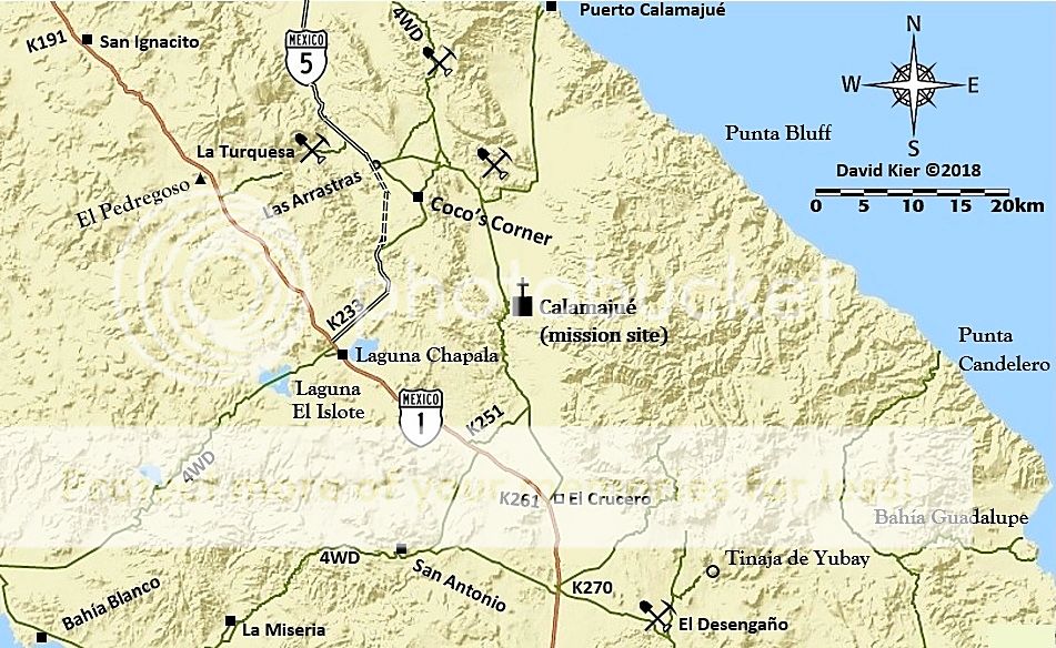
'Las Arrastras' is the region north of Coco's Corner they are naming bridges after because the arroyo is so named by the Mexican topo maps.
Historically, it is Arroyo San Francisquito to where it merges with Arroyo Santa María, near the gulf coast (a roadside rest stop and view area with
a monument is at the Arroyo Santa María bridge, here still called 'Las Arrastras' by the highway sign makers).
More on the history of Las Arrastras (gold ore mills) located where the Coco's Corner bypass and older roads merge on the north end: https://www.bajabound.com/bajaadventures/bajatravel/las_arra...

[Edited on 4-21-2018 by David K]
|
|
|
zipitio
Newbie
Posts: 8
Registered: 3-25-2007
Member Is Offline
|
|
Thank you Baja Nomad members for all your important info. It took us, approximately, 2 hrs to traverse from Chapala Junction to beginning of paved
section. We were our Toyota Sienna van. Moving between 10-25mph. Taking our time and enjoying the views. Also, stopped to say hi to Coco (20 minutes
talking and drinking his cool Coca Colas). I asked him when, he believed, road would finally be paved. He, jokingly, replied:
"In fifty years"  . .
[Edited on 6-26-2018 by zipitio]
|
|
|
David K
Honored Nomad
Posts: 64479
Registered: 8-30-2002
Location: San Diego County
Member Is Offline
Mood: Have Baja Fever
|
|
Was the bypass open... in other words, is the part of the new highway that misses Coco's now open... is it paved yet? Was there a signed road off of
it to Coco's? OR... is the road by Coco's still the route for public traffic?
Thank you!
Any Nomads that have a pen and paper, jot down new kilometer markers at any points, south of Km. 167, please.
|
|
|
zipitio
Newbie
Posts: 8
Registered: 3-25-2007
Member Is Offline
|
|
I did not see any official detours bypassing Coco's corner. It appear to me that "old" route is still the public route. The only active work we saw
was on the Laguna Chapala side. They were paving the first 6 to 10 kms. from Hwy 1 junction.
Coco claimed that once road is finished that it will be off limits to trailer trucks. Any info on this?
[Edited on 6-27-2018 by zipitio]
|
|
|
rts551
Elite Nomad
Posts: 6699
Registered: 9-5-2003
Member Is Offline
|
|
All the paving is being done at Chapala. There is approx 3-4 miles completed and they are working on more. It is not open yet because they are
completing the curbing over the dry lake bed section. The bypass route has not been worked on in quiet a while as the heavy equipment is still
concentrating on blasting through the mountain. It is passable but is not the normal route people travel...that is still through Coco's. This
contractor is much slower than ones past...and get ready for a work stoppage and new contractor after the election...always happens.
|
|
|
David K
Honored Nomad
Posts: 64479
Registered: 8-30-2002
Location: San Diego County
Member Is Offline
Mood: Have Baja Fever
|
|
Thank you, Ralph... a very informative reply.
So no betting on a competition date, I guess?
|
|
|
rts551
Elite Nomad
Posts: 6699
Registered: 9-5-2003
Member Is Offline
|
|
fifty years. And I do not see them limiting traffic...one of the reasons for the road was to push tractor trailers into Mexicali.
|
|
|
thebajarunner
Ultra Nomad
Posts: 3687
Registered: 9-8-2003
Location: Arizona....."Free at last from crumbling Cali
Member Is Offline
Mood: muy amable
|
|
Agreed on the tractor trailer topic.
We were there last year, spent the night close to Coco.
The semis, mostly Rodriguez LP trucks rumbled through night and day.
Of course that was when the big "Huelga" parties were clogging the streets of San Quintin, but nonetheless it cuts off major miles and time to send
produce north into Arizona and beyond.
"50 years" Nah, not a chance.
Couple more years and it will be essentially completed IMO.
|
|
|
David K
Honored Nomad
Posts: 64479
Registered: 8-30-2002
Location: San Diego County
Member Is Offline
Mood: Have Baja Fever
|
|
From Km. 74 (Puertecitos) to Km. 167 (12 mi south of Gonzaga Pemex/76 gas station) the rate of construction and paving had been pretty consistent at
approx. 10 kms per year. Now its been about 4 years of almost no new paving open on the final 20-23 miles to Highway 1.
|
|
|
55steve
Senior Nomad
Posts: 857
Registered: 4-24-2006
Location: Warner Springs, CA
Member Is Offline
|
|
I've driven the road 4 times in the last 4 weeks and only went past Coco's once opting to take the bypass road the other times. Ran the new pavement
for about 1/2 mile from Chapala for close to 5 miles and headed down the somewhat steep embankment back to the dirt. Destination was Papa Fernandez.
[Edited on 6-28-2018 by 55steve]
|
|
|
Frank
Senior Nomad
Posts: 861
Registered: 6-5-2005
Location: San Diego
Member Is Offline
Mood: Is it time to leave yet?
|
|
I went through this morning, northbound. 50 minutes in a loaded down 4Runner. When I went southbound through Mex5 I came up on a sign at a fork in the
road that pointed left to Cocos Corner, to the right was uphill. I went right. Don’t go right, if your pulling a trailer or in a motor home. It was
a great drive, just tight in a few places (boulders and rubble
piles) and a little rough.
A few pics....


|
|
|
thebajarunner
Ultra Nomad
Posts: 3687
Registered: 9-8-2003
Location: Arizona....."Free at last from crumbling Cali
Member Is Offline
Mood: muy amable
|
|
It has frustrated me for several years that they have prepped a significant portion on both ends, yet have deferred final paving of those sections.
They could easily shrink the gap by half in short order, then continue focus on the really tough mid section.
While the mid stretch may yet be a couple years off, the essential amount of unpaved road could be completed quite quickly.
As a developer who has installed streets and roads for the past 40 years I can only scratch my head and wonder what logic drives these projects....
|
|
|
BajaUtah
Nomad
Posts: 190
Registered: 10-4-2013
Location: Salt Lake City/La Ribera
Member Is Offline
|
|
If there is any logic to it (huge if) they don't want to encourage more traffic on to that stretch by paving the ends. More traffic would make their
jobs more difficult and beat up their completed work even faster.
Just a BA Guess
Andy
|
|
|
David K
Honored Nomad
Posts: 64479
Registered: 8-30-2002
Location: San Diego County
Member Is Offline
Mood: Have Baja Fever
|
|
Quote: Originally posted by BajaUtah  | If there is any logic to it (huge if) they don't want to encourage more traffic on to that stretch by paving the ends. More traffic would make their
jobs more difficult and beat up their completed work even faster.
Just a BA Guess |
That is why it seems odd that the section of Hwy. 5 from Hwy. 1 is paved for a few miles (per Ralph). They could easily pave the north end (including
Coco's bypass) right to the mountain cut and then detour to the construction route. That wouldn't 'add' new traffic as the Chapala paved end could.
|
|
|
PaulW
Ultra Nomad
Posts: 3005
Registered: 5-21-2013
Member Is Offline
|
|
The last time a paving project occurred we found the the government in Mexico City provides allocation for the asphalt. Very bureaucratic process and
very slow getting the stuff.
|
|
|
| Pages:
1
2
3 |


