geoffff
Senior Nomad

Posts: 643
Registered: 1-15-2009
Member Is Offline
|
|
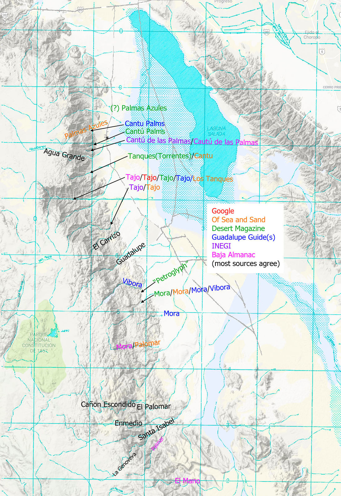
Name the canyons west of Laguna Salada?
Writing up my last trip into the Laguna Salada area, I wanted to properly name the canyons I visited. As with PaulW's in his recent posting about the canyons east side of San Pedro Martir, I thought I might now try to list all the canyons in the east side
of Sierra de Juarez and their names. Yes, I'm a bit of a nerd like that 
It turned out to be surprisingly difficult! Many of the sources conflict. I looked at Google Maps, Bruce Barber's Of Sea and Sand book, various old
articles in Desert Magazine, Rob Williams' Guadalupe Canyon Guidebook, INEGI, and the Baja Almanac. (Desert Magazine doesn't really count, as they
have hand-drawn maps.) These sources usually have the canyons listed named in the same north/south order, but their maps point out different canyons.
Here's what I've found so far:

(click to enlarge)
Cantú Palms - I presume what I have labeled in green is correct, as that's where I went. The others are close, except of Sea and
Sand.
Cañon el Tajo - The majority of sources agree, but not INEGI. Shouldn't INEGI be the ultimate authority?
Vibora Canyon - This name only appears in the maps of the Guadalupe Guidebook, but its two maps disagree! Desert magazine calls it
"Petroglyph Canyon". I visited this and did find petroglyphs.
Cañon la Mora - Most sources show this as one of the canyons I hiked on my last trip, but Baja Almanac shows a different location.
And again the Guadalupe Guidebook maps show two different places.
El Palomar - I'm pretty sure Of Sea and Sand gets this wrong.
Does anyone have the definitive answers here? DavidK?
-- Geoff
[Edited on 3-31-2018 by geoffff]
|
|
|
geoffff
Senior Nomad
Posts: 643
Registered: 1-15-2009
Member Is Offline
|
|
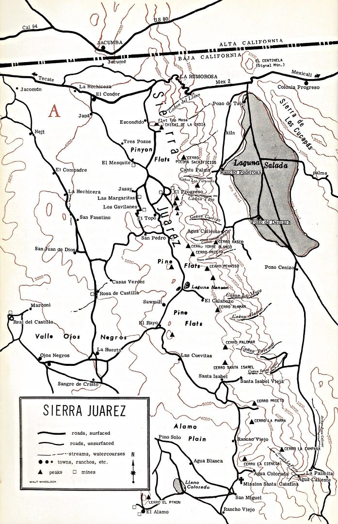
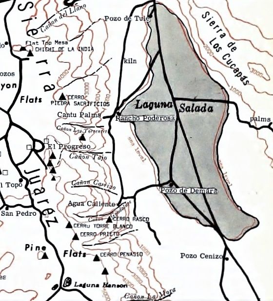
Here are some of my source maps. Click to open.
Of Sand and Sea (my annotations in orange), and Baja Almanac:
 
Desert Magazine: July 1950, June 1958, Jan 1967:
  
|
|
|
PaulW
Ultra Nomad
Posts: 3009
Registered: 5-21-2013
Member Is Offline
|
|
Good job Geoffff, You are way ahead of my effort doing the same.
I trust INEGI, but it so time consuming that my updates for the south area have been neglected.
FYI, I have found I have to make INEGI prints of the area of study from the valley floor all the way to the ridge line. That usually involves two
images. Then I trace all the drainage's on the prints with a soft pencil all the way from the ridge line to the valley and try to find a label along
the way. Of course INEGI neglects to label many of the canyons or drainage paths so then I go to other references.
When I give up on finding a name I choose a landmark off the INEGI map and go with that. When choosing a name I try to avoid the local names that only
the locals use. Example: Azufre (a SCORE label)/ Parral (INEGI) /Crazy Horse (local) are all the same Arroyo.
In the south area I have the advantage of local inquiries that is not possible up north. Then I get the multiple names and some input is good. Of
Course down south I have the ability to drive to most of them.
|
|
|
David K
Honored Nomad
Posts: 64490
Registered: 8-30-2002
Location: San Diego County
Member Is Offline
Mood: Have Baja Fever
|
|
What a super-great job, Geoff!
INEGI is wrong a lot with place names... often switching with a nearby arroyo (El Volcán & Zamora, for example). Some government mapper is Mexico
City are maybe to blame?
Baja Almanac uses the INEGI maps, so the same mistakes are duplicated except where Landon has changed them.
Bruce Barber has a ton of passion but he was not always careful when labeling or adding roads onto the maps he used, but overall the best since John
Robinson (Camping and Climbing in Baja).
Here is John's Map from 1967:
Close up:
[Edited on 3-31-2018 by David K]
|
|
|
geoffff
Senior Nomad
Posts: 643
Registered: 1-15-2009
Member Is Offline
|
|
Thanks, David, for the maps from John Robinson's Camping and Climbing in Baja. I actually ordered my own copy a few days ago, but I got impatient
waiting for it.
Here is my updated map incorporating Camping and Climbing. I'm not sure if the picture is any clearer now Robinson's a hand-drawn map so I shounldn't take it too literally.
Torrentes - Robinson seems to place it directly below Cantu Palmes, where INEGI has Agua Grande (?)
Tajo - Everyone except INEGI and Of Sea and Sand agree with Robinson here.
Mora - Placed at the southern option that matches Baja Almanac.

-- Geoff
[Edit: I crossed off some of the likely errors, which includes most of Of Sea and Sand.]
[Edited on 3-31-2018 by geoffff]
|
|
|
David K
Honored Nomad
Posts: 64490
Registered: 8-30-2002
Location: San Diego County
Member Is Offline
Mood: Have Baja Fever
|
|
Super!
|
|
|
Maderita
Senior Nomad
Posts: 634
Registered: 12-14-2008
Location: San Diego
Member Is Offline
|
|
Geoff, As to the location of Tajo, the old topographic map had labeled the wrong canyon. The upper (northern-most arrow that you drew) is the correct
location. The arrow tip intersects with a horizontal grid line on your map. The upper canyon has two main forks. El Gran Trono Blanco, at the top of
the escarpment, is between the two, above the approximate center of the canyon. The 1600' granite face is a prominent feature from Laguna Salada. Tajo
is the biggest of the eastside canyons.
Easily recognizable on maps/aerial views, the arc of granite crags above Tajo (approx 300' high) extends westward onto the plateau. That granitic arc
is on the eastern edge of the El Topo Pluton, an interesting geologic feature. Not apparent from the ground level, I was the one to inform the owner
of Rancho El Topo about his pluton! ja ja
I see that you have Canyon Alamar on your second map. Yes, it is between La Mora and Palomar. I've explored the upper reaches on horseback. My vaquero
friends have descended and ascended the canyon on horseback, with difficulty. I can't verify that the arrow is on the exact canyon. that would
require some time studying topos and Google Earth.
|
|
|