| Pages:
1
2 |
David K
Honored Nomad

Posts: 64479
Registered: 8-30-2002
Location: San Diego County
Member Is Offline
Mood: Have Baja Fever
|
|
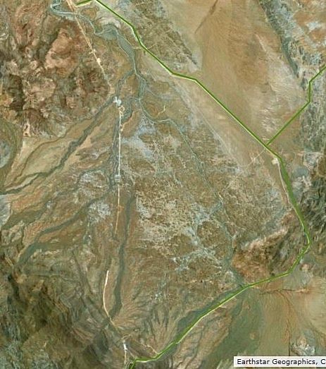
Highway 5 Coco's Bypass on Satellite Images March 2018
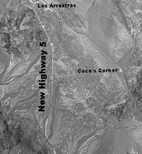
Discovered the new construction all the way to Hwy. 1 is now on some satellite images. Labels and highlight lines added to the older road. The new
highway route is close to where I had estimated it before.
|
|
|
thebajarunner
Ultra Nomad
Posts: 3687
Registered: 9-8-2003
Location: Arizona....."Free at last from crumbling Cali
Member Is Offline
Mood: muy amable
|
|
Very interesting
One of our favorite camp sites is in that photo,
but we are sworn to secrecy as to its exact location.
Poor Coco.
Some will wander over to see him, but not many
|
|
|
David K
Honored Nomad
Posts: 64479
Registered: 8-30-2002
Location: San Diego County
Member Is Offline
Mood: Have Baja Fever
|
|
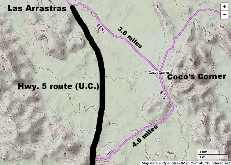
One bit of interest, I had believed the Camino Real went south from Las Arrastras and into the valley south of Coco's before crossing through the
mountains using a canyon, to Calamajué. Howard Gulick placed it that way in 1954 based on what prospectors or ranchers told him and I could see a
trail in this stretch on satellite images. It may have been a parallel trail... the Camino Real is not always just one route between points.
However, Harry Crosby mapped it going north from Calamajué and basically paralleling the dirt road to Las Arrastras.
Well, the GPS Google Earth map from Kevin (after many searches north from Calamajué) found the old trail and he places it about where Harry had. The
'good news' is that Highway 5 south from Las Arrastras is not obliterating El Camino Real, after all.
|
|
|
chippy
Super Nomad
Posts: 1695
Registered: 2-2-2010
Member Is Offline
|
|
Quote: Originally posted by thebajarunner  | Very interesting
One of our favorite camp sites is in that photo,
but we are sworn to secrecy as to its exact location.
Poor Coco.
Some will wander over to see him, but not many
|
Coco should just take his disgusting collection of panties and toilets either 3.8 miles northwest or 4.6 miles southwest and set up shop His shack could be rebuilt in day or two. His shack could be rebuilt in day or two.
|
|
|
TMW
Select Nomad
Posts: 10659
Registered: 9-1-2003
Location: Bakersfield, CA
Member Is Offline
|
|
Coco will be OK. Those that want to drop by his place will and those that don't won't. He has many friends especially in the off road community that
enjoy visiting him and will continue to do so.
|
|
|
David K
Honored Nomad
Posts: 64479
Registered: 8-30-2002
Location: San Diego County
Member Is Offline
Mood: Have Baja Fever
|
|
| Quote: Originally posted by TMW | | Coco will be OK. Those that want to drop by his place will and those that don't won't. He has many friends especially in the off road community that
enjoy visiting him and will continue to do so. |
True, plus he is along the road to California's 17th mission site, located at Calamajué 1766-1767. 
|
|
|
StuckSucks
Super Nomad
Posts: 2305
Registered: 10-17-2013
Member Is Offline
|
|
I looked at Google Maps and (reluctantly) Bing, but I'm not seeing the new alignment -- where are you seeing these?
|
|
|
4x4abc
Ultra Nomad
Posts: 4163
Registered: 4-24-2009
Location: La Paz, BCS
Member Is Offline
Mood: happy - always
|
|
how do you get the images?
Harald Pietschmann
|
|
|
rts551
Elite Nomad
Posts: 6699
Registered: 9-5-2003
Member Is Offline
|
|
looks like maybe Earthstar Geographics (based on the second map) where the Author is SUPPOSED to abide by the licensing agreement. Hopefully no one
turns this one in.
The Licensee accepts Earthstar Geographics copyright of the Data and agrees to "place copyright notice "copyright Earthstar Geographics" on the
Data when distributed"
http://www.terracolor.net/index.html
|
|
|
mtgoat666
Select Nomad
Posts: 17289
Registered: 9-16-2006
Location: San Diego
Member Is Offline
Mood: Hot n spicy
|
|
| Quote: Originally posted by rts551 | looks like maybe Earthstar Geographics (based on the second map) where the Author is SUPPOSED to abide by the licensing agreement. Hopefully no one
turns this one in.
The Licensee accepts Earthstar Geographics copyright of the Data and agrees to "place copyright notice "copyright Earthstar Geographics" on the
Data when distributed"
http://www.terracolor.net/index.html |
Silly rabbit! Items posted on the internet are free! copyright law does not apply! 
Woke!
“...ask not what your country can do for you – ask what you can do for your country.” “My fellow citizens of the world: ask not what America
will do for you, but what together we can do for the freedom of man.”
Prefered gender pronoun: the royal we
|
|
|
David K
Honored Nomad
Posts: 64479
Registered: 8-30-2002
Location: San Diego County
Member Is Offline
Mood: Have Baja Fever
|
|
Sample images posted for educational purposes only.
|
|
|
pacificobob
Super Nomad
Posts: 2237
Registered: 4-23-2006
Member Is Offline
|
|
coco told me a year or two ago that he owned property along the new route. and would be moving his lingerie/ bath fixture display to the new location.
|
|
|
PaulW
Ultra Nomad
Posts: 3005
Registered: 5-21-2013
Member Is Offline
|
|
I am anxiously waiting for your map of these old roads
| Quote: Originally posted by David K | One bit of interest, I had believed the Camino Real went south from Las Arrastras and into the valley south of Coco's before crossing through the
mountains using a canyon, to Calamajué. Howard Gulick placed it that way in 1954 based on what prospectors or ranchers told him and I could see a
trail in this stretch on satellite images. It may have been a parallel trail... the Camino Real is not always just one route between points.
However, Harry Crosby mapped it going north from Calamajué and basically paralleling the dirt road to Las Arrastras.
Well, the GPS Google Earth map from Kevin (after many searches north from Calamajué) found the old trail and he places it about where Harry had. The
'good news' is that Highway 5 south from Las Arrastras is not obliterating El Camino Real, after all. |
|
|
|
rts551
Elite Nomad
Posts: 6699
Registered: 9-5-2003
Member Is Offline
|
|
| Quote: Originally posted by pacificobob | | coco told me a year or two ago that he owned property along the new route. and would be moving his lingerie/ bath fixture display to the new location.
|
Interesting, 5 years ago or so he told me he did not own the property he lived on... (he was a squatter) and therefore could move at anytime (He was
having health problems and contemplating moving to Guerrero Negro or back to Ensenada. Alas, he has some large tales to tell...and I am sure there
would be a crowd of volunteers to help him move (ownership or not).
|
|
|
PaulW
Ultra Nomad
Posts: 3005
Registered: 5-21-2013
Member Is Offline
|
|
Can the rest of of us get the images or do you have a paid account to get them?
The Earthstar web page was not helpful for me.
|
|
|
David K
Honored Nomad
Posts: 64479
Registered: 8-30-2002
Location: San Diego County
Member Is Offline
Mood: Have Baja Fever
|
|
| Quote: Originally posted by PaulW | Can the rest of of us get the images or do you have a paid account to get them?
The Earthstar web page was not helpful for me.
|
They are free, on the Internet.
Edit, I sent you a u2u.
arcgis.com/ is the site. Just change the basemap setting.
[Edited on 4-1-2018 by David K]
|
|
|
David K
Honored Nomad
Posts: 64479
Registered: 8-30-2002
Location: San Diego County
Member Is Offline
Mood: Have Baja Fever
|
|
| Quote: Originally posted by PaulW | I am anxiously waiting for your map of these old roads
| Quote: Originally posted by David K | One bit of interest, I had believed the Camino Real went south from Las Arrastras and into the valley south of Coco's before crossing through the
mountains using a canyon, to Calamajué. Howard Gulick placed it that way in 1954 based on what prospectors or ranchers told him and I could see a
trail in this stretch on satellite images. It may have been a parallel trail... the Camino Real is not always just one route between points.
However, Harry Crosby mapped it going north from Calamajué and basically paralleling the dirt road to Las Arrastras.
Well, the GPS Google Earth map from Kevin (after many searches north from Calamajué) found the old trail and he places it about where Harry had. The
'good news' is that Highway 5 south from Las Arrastras is not obliterating El Camino Real, after all. |
|
Thanks... that is now my current project. Max Kurillo and I are going to revive and supplement Harry Crosby's book, Gateway to Alta California. In it,
Harry and his team have found and mapped the Serra/ Crespi 1769 trail from Mission San Fernando de Velicatá to San Diego. It basically was the
continuation of Harry's 'The King's Highway in Baja California' with more detailed maps thanks to GPS. I thought that including the rest of the trail
up from Loreto to San Fernando would be a nice addition and Max agreed.
Have you looked at Kevin's Google Earth El Camino Real locator? http://caminorealbaja.com/
|
|
|
mtgoat666
Select Nomad
Posts: 17289
Registered: 9-16-2006
Location: San Diego
Member Is Offline
Mood: Hot n spicy
|
|
| Quote: Originally posted by David K | | Quote: Originally posted by PaulW | Can the rest of of us get the images or do you have a paid account to get them?
The Earthstar web page was not helpful for me.
|
They are free, on the Internet.
Edit, I sent you a u2u.
arcgis.com/ is the site. Just change the basemap setting.
[Edited on 4-1-2018 by David K] |
They are only “free” for personal use, and only in accordance with the agreement you entered into with esri.
Woke!
“...ask not what your country can do for you – ask what you can do for your country.” “My fellow citizens of the world: ask not what America
will do for you, but what together we can do for the freedom of man.”
Prefered gender pronoun: the royal we
|
|
|
David K
Honored Nomad
Posts: 64479
Registered: 8-30-2002
Location: San Diego County
Member Is Offline
Mood: Have Baja Fever
|
|
The missions and Baja California are very personal with me... Just like you telling others what they can do or not do is.
|
|
|
Jaybo
Nomad
Posts: 240
Registered: 12-7-2009
Location: NW Oregon
Member Is Offline
Mood: Praying for Baja!
|
|
all I see is the 21 day free trial otherwise it is $9/month billed annually?
|
|
|
| Pages:
1
2 |


