| Pages:
1
2
3 |
bajaguy
Elite Nomad

Posts: 9247
Registered: 9-16-2003
Location: Carson City, NV/Ensenada - Baja Country Club
Member Is Offline
Mood: must be 5 O'clock somewhere in Baja
|
|
John....ever read the Monkey Wrench Gang???......a classic
https://en.wikipedia.org/wiki/The_Monkey_Wrench_Gang
|
|
|
David K
Honored Nomad
Posts: 64479
Registered: 8-30-2002
Location: San Diego County
Member Is Offline
Mood: Have Baja Fever
|
|
Quote: Originally posted by John Harper  | I stopped on the way out of Mike's at the area I think was the old landing strip. I'm not really sure cause it did not look like the satellite view I
expected. Of course, neither did the arroyo.
There were some signs saying it was a natural area under restoration, not sure the exact wording. So, some environmental attention has been on this
area. Maybe I should contact someone? A little late now, but maybe they can find these scumbag's dozer and disable it.
John |
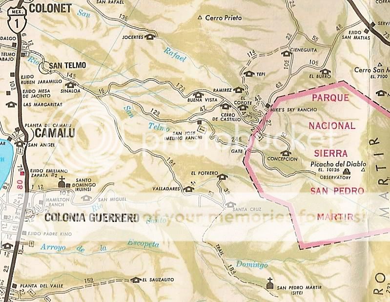
Mike's first airstrip was to the south, at Los Encinos, it was crooked!

Mike's New Runway was to the north, along the road to Hwy. 3...

Once the government mandated the military at all airports and required great sums of money from airport owners, Mike closed the airport. Nearly all of
his business was no longer flying in, anyway. Still called a "Sky Ranch" however.
|
|
|
bajatrailrider
Super Nomad
Posts: 2423
Registered: 1-24-2015
Location: Mexico
Member Is Offline
Mood: Happy
|
|
| Quote: Originally posted by John Harper | I stopped on the way out of Mike's at the area I think was the old landing strip. I'm not really sure cause it did not look like the satellite view I
expected. Of course, neither did the arroyo.
There were some signs saying it was a natural area under restoration, not sure the exact wording. So, some environmental attention has been on this
area. Maybe I should contact someone? A little late now, but maybe they can find these scumbag's dozer and disable it.
John |
There all on the take just trace the money they look the other way.
|
|
|
John Harper
Super Nomad
Posts: 2289
Registered: 3-9-2017
Location: SoCal
Member Is Offline
|
|
| Quote: Originally posted by David K | | Quote: Originally posted by John Harper | I stopped on the way out of Mike's at the area I think was the old landing strip. I'm not really sure cause it did not look like the satellite view I
expected. Of course, neither did the arroyo.
There were some signs saying it was a natural area under restoration, not sure the exact wording. So, some environmental attention has been on this
area. Maybe I should contact someone? A little late now, but maybe they can find these scumbag's dozer and disable it.
John |
Mike's first airstrip was to the south, at Los Encinos, it was crooked!
Mike's New Runway was to the north, along the road to Hwy. 3...
Once the government mandated the military at all airports and required great sums of money from airport owners, Mike closed the airport. Nearly all of
his business was no longer flying in, anyway. Still called a "Sky Ranch" however. |
David, that's exactly where I stopped, perhaps I didn't walk east enough, or it's well overgrown now.
John
|
|
|
David K
Honored Nomad
Posts: 64479
Registered: 8-30-2002
Location: San Diego County
Member Is Offline
Mood: Have Baja Fever
|
|
Which one John, I showed both airstrips Mike's Sky Rancho used? The second (lower) one (above) is 6 miles north of the rancho, alongside the road to
Hwy. 3.
|
|
|
John Harper
Super Nomad
Posts: 2289
Registered: 3-9-2017
Location: SoCal
Member Is Offline
|
|
I stopped at where I thought the north airstrip was located on our way out of Mike's. I noticed it on Google maps but it looked different than I
expected.
We just hiked, camped, and fished from Mike's up to Rancho Garate (Las Truchas) then hoofed it down the road back to Mike's for a much needed cold
Pacifico late in the day. That's when I saw all new roads cut.
John
[Edited on 5-3-2018 by John Harper]
|
|
|
David K
Honored Nomad
Posts: 64479
Registered: 8-30-2002
Location: San Diego County
Member Is Offline
Mood: Have Baja Fever
|
|
10-4, the New (in 1985) airport, north of Mike's.
The road south from Mike's to El Coyote and Meling's is really for trail bikes and rock crawler 4x4s, maybe. Too bad, as it sure makes for a nice loop
drive if they run a dozer over it again. Have done that road many times, in the past (2005, 1978, 1974, 1972).
2005 Trip; photos and road log: http://vivabaja.com/905/
|
|
|
John Harper
Super Nomad
Posts: 2289
Registered: 3-9-2017
Location: SoCal
Member Is Offline
|
|
| Quote: Originally posted by David K | 10-4, the New (in 1985) airport, north of Mike's.
The road south from Mike's to El Coyote and Meling's is really for trail bikes and rock crawler 4x4s, maybe. Too bad, as it sure makes for a nice loop
drive if they run a dozer over it again. Have done that road many times, in the past (2005, 1978, 1974, 1972).
2005 Trip; photos and road log: http://vivabaja.com/905/ |
Yes, some pretty rough spots, especially near the upper creek crossing, looks like an almost vertical drop, easy rollover spot. My buddy who was with
me has a lifted 4WD Tacoma back home and he said he would not do that road. Dirt bike, no problem. I may even bring one out next year to ferry a few
bags of trash back to Mike's. The arroyo had several bad spots of diapers, beer bottles, and cans. So sad.
Personally, the less people up that road the better for the arroyo, and the rare trout. They're barely hanging on now. Glad there's another way to
El Coyote.
John
[Edited on 5-3-2018 by John Harper]
|
|
|
bajatrailrider
Super Nomad
Posts: 2423
Registered: 1-24-2015
Location: Mexico
Member Is Offline
Mood: Happy
|
|
HAAA that route Ed Hall went a short ways in his Jeep smart man turned went back. On dirt bike good rider yes fun weak rider hand full. From that road
there is a old road going up to Forest just about 4 /5 miles above park office. For last 25 years that I Know only passable on Moto very hard route
need skilled riders. Your can not come out on paved road up in park as of many years ago. Still fun to ride up the views unreal go back the way you
came. Maybe you have the route on one of your Maps David. The road was destroyed by flood in late 70s or early 80s. For any hikers would also be great
route. Don't know where you would go at bottom walking. Spend the night at Mikes then walk back next day.
|
|
|
David K
Honored Nomad
Posts: 64479
Registered: 8-30-2002
Location: San Diego County
Member Is Offline
Mood: Have Baja Fever
|
|
The 2018 Trail of Missions tour (Ford Raptors mostly) ran the road out of Mike's to Meling and showed it on their TV special last Sunday... They
needed spotters in one section and a lot of scratched rocks from dragging the underside of the trucks over this road.
|
|
|
shari
Select Nomad
Posts: 13033
Registered: 3-10-2006
Location: bahia asuncion, baja sur
Member Is Offline
Mood: there is no reality except the one contained within us "Herman Hesse"
|
|
Wow....I had scroll back up to see who posted this...gotta say Bajaguy...you were the last guy I would have imagined...hahahaha...
those yucca trunks are also used in bird cages for nesting. They rot away pretty quick so I think its OK to use them and if cut right, the baby
offshoot plants continue on....and lets not forget they were used as Xmas trees in our area....the top part with the branches.
|
|
|
JoeJustJoe
Banned
Posts: 21045
Registered: 9-9-2010
Location: Occupied Aztlan
Member Is Offline
Mood: Mad as hell
|
|
What hypocrisy, about some Nomads, crying about some Yucca threes being cut down, and are not even on any kind of endangered list.
Oh but when a Mexican, environmental group, complains, about the Baja 1000, charging courses and trampling on protected areas of Valle de los Cirious,
and El Vizcaino, and actually destroying endangered plants, and doing all kinds of other damages, that's OK, and just Mexico, trying to get bribes
from the American sponsors of the race.
The American bias is many times unhinged on this Baja site.
|
|
|
ehall
Super Nomad
Posts: 1906
Registered: 3-29-2014
Location: Buckeye, Az
Member Is Offline
Mood: It's 5 o'clock somewhere
|
|
| Quote: Originally posted by David K | | The 2018 Trail of Missions tour (Ford Raptors mostly) ran the road out of Mike's to Meling and showed it on their TV special last Sunday... They
needed spotters in one section and a lot of scratched rocks from dragging the underside of the trucks over this road. |
That didnt look to me like the road to dark skies that Larry is talking about. It looked like the road directly behind Mike's headed towards
coyote. Better get us a map. Lol. Or email Cameron and ask him.
|
|
|
freediverbrian
Senior Nomad
Posts: 615
Registered: 2-24-2007
Location: Papas Gonzaga Bay
Member Is Offline
|
|
If SCORE was behind it it's ok because they bring so much to Baja😉
|
|
|
David K
Honored Nomad
Posts: 64479
Registered: 8-30-2002
Location: San Diego County
Member Is Offline
Mood: Have Baja Fever
|
|
| Quote: Originally posted by ehall | | Quote: Originally posted by David K | | The 2018 Trail of Missions tour (Ford Raptors mostly) ran the road out of Mike's to Meling and showed it on their TV special last Sunday... They
needed spotters in one section and a lot of scratched rocks from dragging the underside of the trucks over this road. |
That didnt look to me like the road to dark skies that Larry is talking about. It looked like the road directly behind Mike's headed towards
coyote. Better get us a map. Lol. Or email Cameron and ask him. |
Larry's post from last May?
I wasn't responding to it Ed, I just wanted to mention the normal south road was on the Trail of Missions show... It is the most direct road to Rancho
Meling from Mike's and yes, it goes right by El Coyote. I was on it last year, but I had my rear brake failure about 3-4 miles from El Coyote heading
to Mike's, so I turned around and limped back. Larry was there with a group of riders. So, between his advice, his vise grip pliers, and some rubber
tube from Michael Diogo, I could get home.

|
|
|
ehall
Super Nomad
Posts: 1906
Registered: 3-29-2014
Location: Buckeye, Az
Member Is Offline
Mood: It's 5 o'clock somewhere
|
|
Thanks buddy. Got it.
|
|
|
TMW
Select Nomad
Posts: 10659
Registered: 9-1-2003
Location: Bakersfield, CA
Member Is Offline
|
|
| Quote: Originally posted by ehall | | Quote: Originally posted by David K | | The 2018 Trail of Missions tour (Ford Raptors mostly) ran the road out of Mike's to Meling and showed it on their TV special last Sunday... They
needed spotters in one section and a lot of scratched rocks from dragging the underside of the trucks over this road. |
That didnt look to me like the road to dark skies that Larry is talking about. It looked like the road directly behind Mike's headed towards
coyote. Better get us a map. Lol. Or email Cameron and ask him. |
Ed the road to Dark Skies is to the left when you cross the water going into Mike's from Highway 3. It's about 6 miles to a junction where you turn
left and follow that to Dark Skies for about another 5 or 6 miles.
|
|
|
Skipjack Joe
Elite Nomad
Posts: 8084
Registered: 7-12-2004
Location: Bahia Asuncion
Member Is Offline
|
|
‘Harvesting’ the landscape - outrageous.
|
|
|
ehall
Super Nomad
Posts: 1906
Registered: 3-29-2014
Location: Buckeye, Az
Member Is Offline
Mood: It's 5 o'clock somewhere
|
|
| Quote: Originally posted by TMW | | Quote: Originally posted by ehall | | Quote: Originally posted by David K | | The 2018 Trail of Missions tour (Ford Raptors mostly) ran the road out of Mike's to Meling and showed it on their TV special last Sunday... They
needed spotters in one section and a lot of scratched rocks from dragging the underside of the trucks over this road. |
That didnt look to me like the road to dark skies that Larry is talking about. It looked like the road directly behind Mike's headed towards
coyote. Better get us a map. Lol. Or email Cameron and ask him. |
Ed the road to Dark Skies is to the left when you cross the water going into Mike's from Highway 3. It's about 6 miles to a junction where you turn
left and follow that to Dark Skies for about another 5 or 6 miles. |
Yep. Took it a couple miles back to an off camber spot that was completely washed out. Maybe a foot or so of road left next to the cliff. Had to back
up a 1/4 mile to turn around.
|
|
|
bajatrailrider
Super Nomad
Posts: 2423
Registered: 1-24-2015
Location: Mexico
Member Is Offline
Mood: Happy
|
|
Don't need to worry anymore the yacca rapers have put another 25 roads in
Just below the park what a mess . We saw all on our Moto ride.
|
|
|
| Pages:
1
2
3 |


