Bajazly
Senior Nomad

Posts: 992
Registered: 6-4-2015
Location: Goodbye Cali and Hello San Felipe
Member Is Offline
Mood: More Relaxed Everyday
|
|
Old Puertocitos road getting flatter.
Driving down and back this past week, there are two stretches of construction near
the south part of the old road right before you hit the newer road south. They have about two dozen or more vados dug up putting pipes in along with a
couple new major puentes. Neither section is more than a couple miles and the temp road is pretty good. Sorry if this has been posted before but it
was a surprise to me when we come up on it, hadn't seen anything about it here.
Believing is religion - Knowing is science
Harald Pietschmann
"Get off the beaten path and memories, friends and new techniques are developed"
Bajazly, August 2019
|
|
|
freediverbrian
Senior Nomad
Posts: 615
Registered: 2-24-2007
Location: Papas Gonzaga Bay
Member Is Offline
|
|
Good to hear it's been a bad section of road for twenty years or more years, it has been patched many times with little long term solution.
|
|
|
David K
Honored Nomad
Posts: 64480
Registered: 8-30-2002
Location: San Diego County
Member Is Offline
Mood: Have Baja Fever
|
|
Sounds like the new inland route we have heard about, to replace the 1983 route that was put along the coast? The inland route was made in the 1950s
from the sulfur mine south...
|
|
|
freediverbrian
Senior Nomad
Posts: 615
Registered: 2-24-2007
Location: Papas Gonzaga Bay
Member Is Offline
|
|
Quote: Originally posted by David K  | | Sounds like the new inland route we have heard about, to replace the 1983 route that was put along the coast? The inland route was made in the 1950s
from the sulfur mine south... |
I think you are right, the section of road they are working on is the same type of construction method as the road south to Gonzaga. A 10 km side road
, making small bridges and culverts . Set up a cement plant . The construction starts one km north of cowpattys and heads north.
Maybe they are building the road south to north?? The road north of the work zone is terrible the worst I have seen in 10 or more years more pot
holes than road.
|
|
|
PaulW
Ultra Nomad
Posts: 3005
Registered: 5-21-2013
Member Is Offline
|
|
This section of new construction on Hwy 5 is between Cow Paddy on the south and Matomi on the north or maybe further north by now. That new
construction began in late April.
There is no construction on OPR (old Puerticitis Road) which is further inland and is still a terrible road to drive.
|
|
|
David K
Honored Nomad
Posts: 64480
Registered: 8-30-2002
Location: San Diego County
Member Is Offline
Mood: Have Baja Fever
|
|
Thanks for clearing that up, Paul.
OPR meets Hwy. 5 a few miles north of Matomi.
|
|
|
freediverbrian
Senior Nomad
Posts: 615
Registered: 2-24-2007
Location: Papas Gonzaga Bay
Member Is Offline
|
|
Don't know "opr" road, or matomi wash. new construction is parallel to existing road. KISS!!
[Edited on 6-4-2018 by freediverbrian]
|
|
|
PaulW
Ultra Nomad
Posts: 3005
Registered: 5-21-2013
Member Is Offline
|
|
It is an interesting that the new road construction has begun from the south.
The start of the new construction is just north of Cowpatty at about KM 73 just north of the turn to Puerticitos at KM 74.6. A landmark on Hwy 5 is
Matomi Wash at KM 60. The junction of the "Old Puericotos Road" (OPR) with Hwy 5 is at KM 52.5.
It will be a significant event when the new construction reaches KM 52.5 because many of us have long speculated that a realignment of Highway 5
would follow the track of OPR?
David's thread documents the progress of the transition from OPR to Highway 5. at http://forums.bajanomad.com/viewthread.php?tid=89302#pid1109...
Fixed name Cpwpatty and location KM73
It was documented on the 2007 AAA map that highway 5 was paved the first time, and patched many more time in following years.
Thank you David for for your maps.
[Edited on 6-4-2018 by PaulW]
|
|
|
David K
Honored Nomad
Posts: 64480
Registered: 8-30-2002
Location: San Diego County
Member Is Offline
Mood: Have Baja Fever
|
|
Thank you Paul. A map is like a window back in time!
The 1996 AAA map was the first I posted showing the pavement complete to Puertecitos. The new roadbed is first shown on my collection on the 1987 map.
It was built in 1982-83.
In 1987, the paving was advancing south, just past Punta Estrella Beach area (now the Valle de los Gigantes turnoff).
TW reported the pavement was to Puertecitos in 1990, as I recall.
Once the new road passed Coloradito, it took a turn inland and intersected the old road, 4.6 miles north of Matomí arroyo. The new and old roads were
the same alignment on to Puertecitos from that intersection.
|
|
|
PaulW
Ultra Nomad
Posts: 3005
Registered: 5-21-2013
Member Is Offline
|
|
| Quote: Originally posted by PaulW | It is an interesting that the new road construction has begun from the south.
The start of the new construction is just north of Cowpatty at about KM 73 just north of the turn to Puerticitos at KM 74.6. A landmark on Hwy 5 is
Matomi Wash at KM 60. The junction of the "Old Puericotos Road" (OPR) with Hwy 5 is at KM 52.5.
It will be a significant event when the new construction reaches KM 52.5 because many of us have long speculated that a realignment of Highway 5
would follow the track of OPR?
David's thread documents the progress of the transition from OPR to Highway 5. at http://forums.bajanomad.com/viewthread.php?tid=89302#pid1109...
It was documented on the 2007 AAA map that highway 5 was paved the first time, and patched many more time in following years. (David said Tom reported
pavement was completer in 1990).
Thank you David for for your maps.
[Edited on 6-4-2018 by PaulW] |
Fixed name Cowpatty and location at KM73
|
|
|
PaulW
Ultra Nomad
Posts: 3005
Registered: 5-21-2013
Member Is Offline
|
|
Good maps. I did not about know the El Coloradito dog leg to OPR although it is clearly shown on my map. Anyway, my KMs are correct as the final
junction old to new is at KM 52.5. Whereas El Coloradito would have been close to KM 42.3, but I do not know exactly which road leads to it. I must
have missed the sign?
This means the distance from that dogleg on OPR to Matomi would be about 17.7KM/11mi not the 7.4km/4.6mi you mentioned.
You said, “Once the new road passed Coloradito, it took a turn inland and intersected the old road, 4.6 miles north of Matomí arroyo.”
Could you look close at the map and see if you can find a 10+ KM error. Your 4.6mi/7.4km should be about 17km/11mi per my map. I cannot read the
numbers on the small image you posted.
Fun converting back and forth. All my stuff is in KM and all yours is in miles. – No problem.
BTW. My error - Cowpatty is the correct name and it is at KM 73.
|
|
|
David K
Honored Nomad
Posts: 64480
Registered: 8-30-2002
Location: San Diego County
Member Is Offline
Mood: Have Baja Fever
|
|
Hi Paul,
Doing my most recent recordings of km markers, I was only seeking campgrounds and facilities for travelers so the places like Coloradito and Costa
Verde I didn't note. However, on a 2011 trip I did mark down some things we are discussing...
Km. 32 Nuevo Mazatlán
Km. 35.5 Colonia Delicias
Km. 49 El Coloradito
Km. 54 Campo Cristina
Km. 58.5 Los Olivos
Km. 60 Arroyo Matomí
Km. 60+ San Rafael
Km. 74.5 Puertecitos Road
The distance from Coloradito to Matomí is 11 kms. (6.8 miles).
The Old Road junctions between these two, you can see it on Google Earth and the AAA map and Almanac. The new development Rancho Costa Verde entrance
is right by the Old Road junction, just past it.
I did a Google Earth path measurement and here are the results:
OPR to Matomi Wash Road (Km. 60) is 4.6 miles and OPR to Coloradito Road is 2.2 miles...
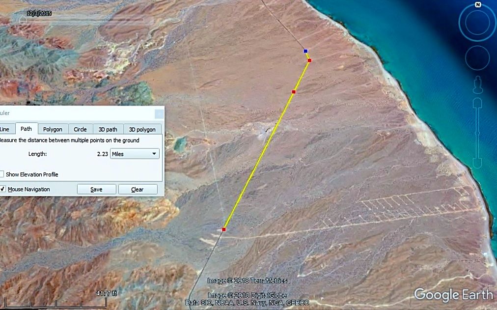
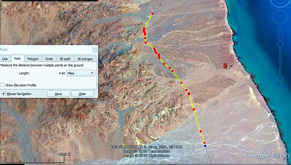
The AAA map also has Old Puertecitos road and they also show it as 2.2 miles from the Coloradito road and 1.2 miles (2 kms.) from the Campo Cristina
road...
All this puts the OPR around Km. 52/53, as you have it. Your km. for Coloradito is the only error I think?
There was once a sign for Ejido Matomí, just a sign. The auto club placed it with a black box on their map as if it was a building or rancho... it
never was.
[Edited on 6-5-2018 by David K]
|
|
|
PaulW
Ultra Nomad
Posts: 3005
Registered: 5-21-2013
Member Is Offline
|
|
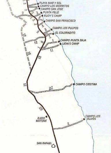
GPS images
Thanks, All is confirmed. My Gps does not show San Rafael I suppose it is the small rancho at the water well. West side just a short distance from the
Matomi turn.
BTW, here are the images I have been using from my desktop Lowrance GPS. The map is from Murdock and includes dots along the highway that are actual
waypoints made as he drove along the highway. Of course, they are 1 KM apart to allow you to count to locate each road turn off.


|
|
|
David K
Honored Nomad
Posts: 64480
Registered: 8-30-2002
Location: San Diego County
Member Is Offline
Mood: Have Baja Fever
|
|
San Rafael (by the old, deep well) is now called El Pozo, 1/2 km. south of the primary road in Arroyo Matomí. There was a sign advertising sodas for
sale.
For fun, here is a map I made in 1978 when I compared driving the beach route and on the beach to driving the road, between San Felipe and
Puertecitos. I took mileage readings along both routes. The most difficult part was the gravel beach around Punta San Fermin... like driving on ball
bearings. This was in my 4WD Subaru with 13" tires!
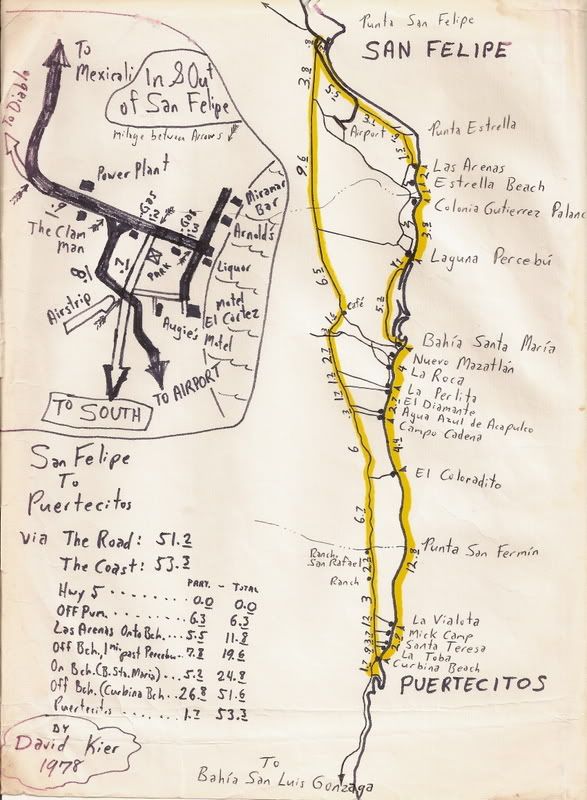
Beach Route Log:
0.0 Hwy. 5 in San Felipe
6.3 Leave airport road, off pavement
11.8 Onto beach, Las Arenas (today Villa Marina)
19.6 Off beach, 1 mile south of Percebu (onto salt flat)
24.8 Onto beach near Bahia Santa Maria (Playa Hermosa)
51.6 Off beach at Curbina Beach (near Cow Patty, today)
53.3 Puertecitos (Restaurant, gasoline)
[Edited on 6-5-2018 by David K]
|
|
|


