| Pages:
1
2 |
JZ
Elite Nomad

Posts: 9217
Registered: 10-3-2003
Member Is Offline
|
|
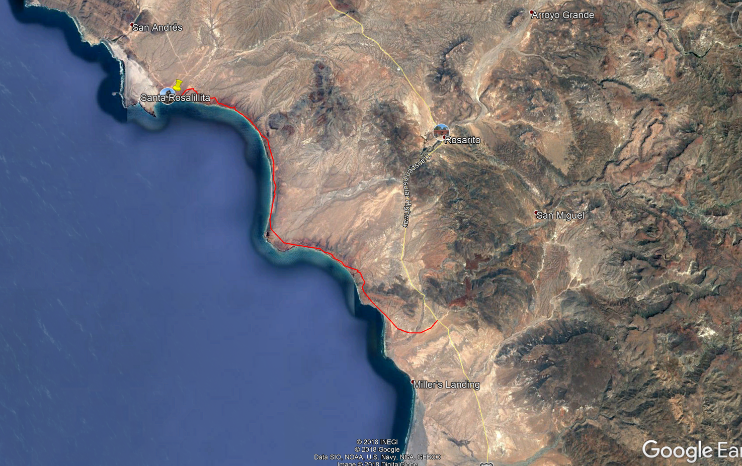
Can you take a truck South of Santa Rosalillita along the coast and then cut in to Hwy 1?
Looks like you can on GE. About 20 miles or so?
One 2 mile stretch I haven't found the route yet. So wondering if it goes through?
[Edited on 5-27-2018 by JZ]
[Edited on 5-28-2018 by BajaNomad]
|
|
|
motoged
Elite Nomad
Posts: 6481
Registered: 7-31-2006
Location: Kamloops, BC
Member Is Offline
Mood: Gettin' Better
|
|
Isn't the south end of that track a "haunted" beach where cars batteries mysteriously die? And where stone circles and weird things happen?

Don't believe everything you think....
|
|
|
playa azul
Newbie
Posts: 2
Registered: 5-26-2018
Member Is Offline
|
|
yes. 2wd is fine. a fun short run. when you pop out on hwy 1
go north 6 miles to Nuevo rosarito and stay at the Baja cactus motel. great seafood restaurant next door.
|
|
|
David K
Honored Nomad
Posts: 64476
Registered: 8-30-2002
Location: San Diego County
Member Is Offline
Mood: Have Baja Fever
|
|
Good morning.
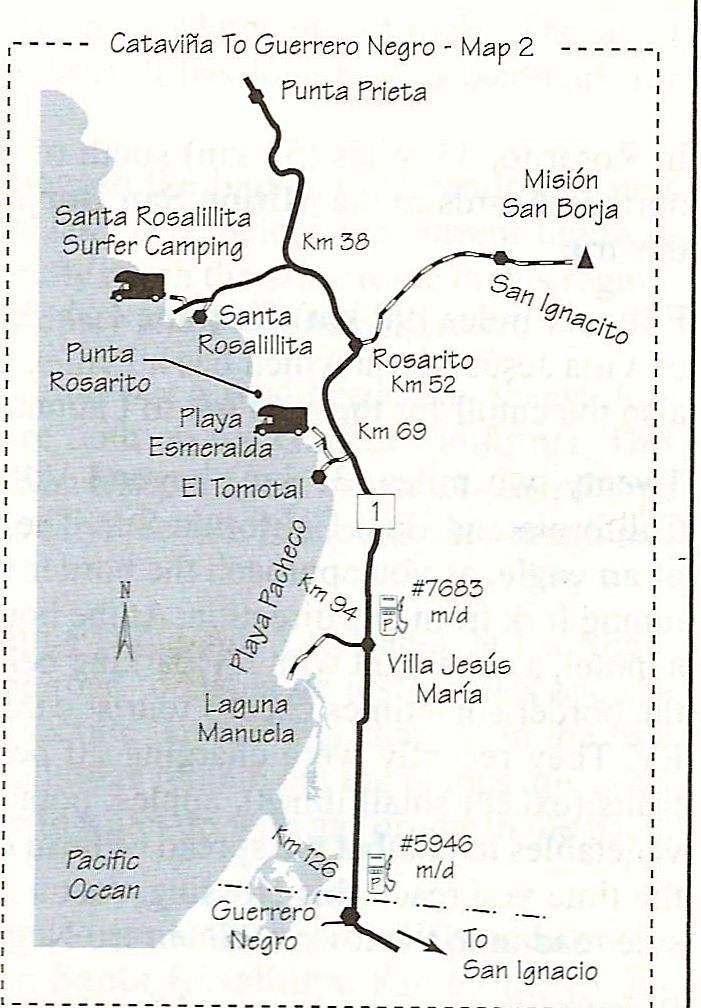
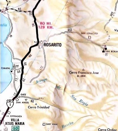
JZ, it is 18 miles from Sta. Rosalillita to Hwy. 1 at km. 62.5 (6 mi from Nuevo Rosarito).
I drove it in 2007 and it was a pretty slow drive. It passes the access road to Punta Rosarito (The Wall, in surfer code) and a former known grave of
a child where it leaves the coast. Old maps call that place El Muertito (if I am remembering the name correctly). That may be the confusion with El
Tomatal that Ged is thinking of.
Ged, you are thinking of El Tomatal which is just south at km.69 and on the coast. The mystery there was told to us by Michelle, see www.vivabaja.com/et .
Playa Azul, the motel in Nuevo Rosarito (km. 52) is the Hotel Cactus next to Mauricio's restaurant. Baja Cactus Motel is in El Rosario.
Keep up the Baja love!
|
|
|
motoged
Elite Nomad
Posts: 6481
Registered: 7-31-2006
Location: Kamloops, BC
Member Is Offline
Mood: Gettin' Better
|
|
Thanks for the clarification....hope to see that area this coming winter....
Don't believe everything you think....
|
|
|
chippy
Super Nomad
Posts: 1695
Registered: 2-2-2010
Member Is Offline
|
|
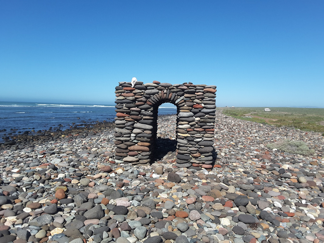
Easypeasy when dry. More fun when wet.
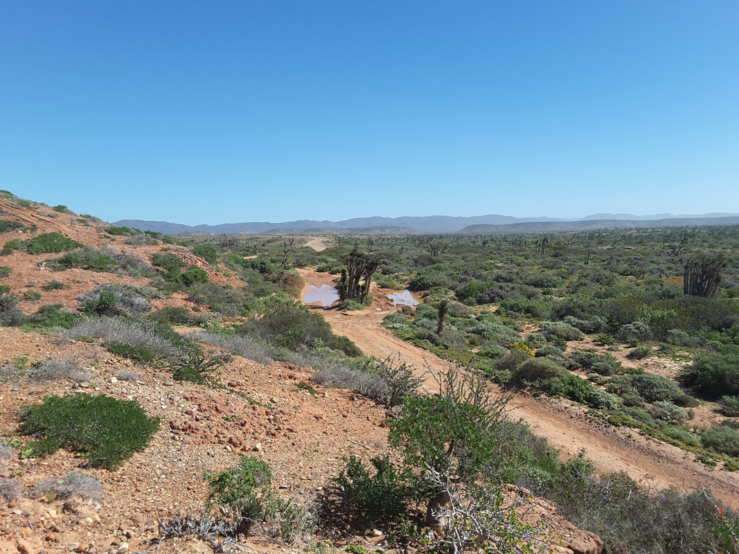 screen grab screen grab
The wall (punta rosarito)
[Edited on 5-28-2018 by BajaNomad]
|
|
|
hermosok123
Nomad
Posts: 102
Registered: 12-11-2016
Member Is Offline
|
|
Long wheel base vehicles will have to watch the bottom out factor or should I say the rear bottom out factor. A couple of sharp arroyos that require
taking the angle approach. Doable as long as we don't get some Summer rain.
|
|
|
Archie
Nomad
Posts: 163
Registered: 4-23-2012
Member Is Offline
|
|
In the track you created you cannot go the last miles from "El muertito" beach to "El Tomatal" fish camp. There's a single track doable on a bike or
quad, but i´ve never seen a biker coming or going.
I´ve tried twice, the first time i came all the way from laguna Manuela driving on the beach and tried to go up north from el tomatal up the hill
behind the fishermen shacks, a humvee full of soldiers catch up with me very quick and scolded me for trying to bypass the checkpoint. Not fun.
The second time i got a permit from the ejido Nuevo Rosarito as i was doing some land survey and checked first with the personnel at the checkpoint,
got clearance and went on, but this time a mexican navy patrol in one of those sweet unimogs was waiting for me on the beach and got the same
treatment. They were surprised i got that far, i was on my jeep cherokee on 35's, long travel suspension and lockers front and rear.
It happens that this is a very popular place for drug traffic, refueling boats and loading/unloading goods.
To go to "El muerttito" beach there´s a dirt road that takes you there just a few miles up north of the military checkpoint to Hwy 1. Used to be a
very good spot for shore fishing, now its popular among surfers and weekend campers.
[Edited on 5-27-2018 by Archie]
|
|
|
JZ
Elite Nomad
Posts: 9217
Registered: 10-3-2003
Member Is Offline
|
|
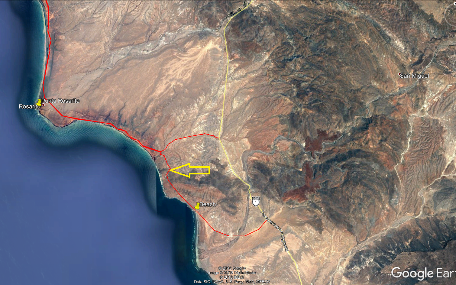
Archie, that was exactly my question.
So you are saying the section with the arrow isn't passable and I need to take the Northern route up to the hwy, correct?
Is what I labeled "beach" the El Tomatal fish camp?
[Edited on 5-27-2018 by JZ]
[Edited on 5-28-2018 by BajaNomad]
|
|
|
woody with a view
PITA Nomad
Posts: 15937
Registered: 11-8-2004
Location: Looking at the Coronado Islands
Member Is Offline
Mood: Everchangin'
|
|
Correct. Your upper road heading to the beach comes out at a surf spot called Wimps and Gimps and goes north from there. Go to the military check
point and go towards the ocean and hang a left along the coast.
|
|
|
JZ
Elite Nomad
Posts: 9217
Registered: 10-3-2003
Member Is Offline
|
|
Thx. We are coming down from the North. Going to ride the entire Seven Sisters and then head down to Loreto. We'll cut back over to the Hwy here.
Gonna do it in July.
|
|
|
David K
Honored Nomad
Posts: 64476
Registered: 8-30-2002
Location: San Diego County
Member Is Offline
Mood: Have Baja Fever
|
|
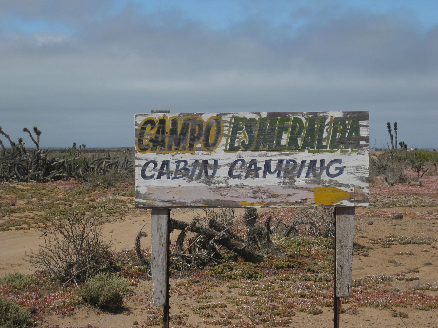
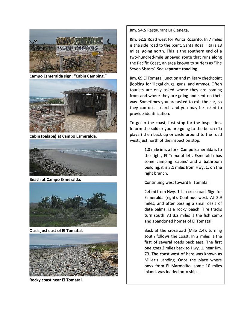
Beach (on your map) is Campo Esmeralda which is a couple miles north of El Tomatal. Tomatal is a fishing camp and several abandoned-looking homes.
Esmeralda is a campo for tourists. Photos and details all posted last year in my trip reports... #4, I think?
|
|
|
Archie
Nomad
Posts: 163
Registered: 4-23-2012
Member Is Offline
|
|
Quote: Originally posted by JZ  | Archie, that was exactly my question.
So you are saying the section with the arrow isn't passable and I need to take the Northern route up to the hwy, correct?
Is what I labeled "beach" the El Tomatal fish camp?
[Edited on 5-27-2018 by JZ] |
Yes and yes.
I think DK has his map upside down, La Esmeralda its a few kilometers south of El Tomatal and its indeed a fish camp. I have some friends living there
full time.
I guess he's taking his notes from the Almanac, wich by the way names the long stretch of beach as "Playa Pacheco" but nobody around here calls it
that, here we know it as "El playón". We don't even know who that Pacheco guy is, although i remember reading somewhere on the web some text that he
claims it was named after him.
[Edited on 5-28-2018 by BajaNomad]
|
|
|
David K
Honored Nomad
Posts: 64476
Registered: 8-30-2002
Location: San Diego County
Member Is Offline
Mood: Have Baja Fever
|
|
When you finish getting inspected at the checkpoint, the road for El Tomatal goes west and partway in is a signed fork right (northwest) for
Esmeralda. A second road to Esmeralda north is crossed before passing the date palms and arriving at the beach. Turning south at the beach soon takes
you to El Tomatal. Campo Esmeralda is indeed north of Tomatal at the base of the hill.
|
|
|
WestyWanderer
Nomad
Posts: 276
Registered: 10-24-2014
Location: San Clemente, CA
Member Is Offline
|
|
JZ, drove the route south from Santa Rosalilita to the wall and then out the wash south of the wall in November in my 4 door Tacoma. There were two
spots where 4WD was needed because of washed out arroyos and it was very slow going but definitely do-able. I cannot speak to the route south of
that. Hope this helps
|
|
|
tiotomasbcs
Super Nomad
Posts: 1837
Registered: 7-30-2007
Location: El Pescadero
Member Is Offline
|
|
And...the Spirits?!! Usually a result of leaving car stereo on all night and alittle ..Spirits. Used to camp out on the beaches there going
south...empty! Except for Coyotes! Tio
|
|
|
Archie
Nomad
Posts: 163
Registered: 4-23-2012
Member Is Offline
|
|
| Quote: Originally posted by David K | | When you finish getting inspected at the checkpoint, the road for El Tomatal goes west and partway in is a signed fork right (northwest) for
Esmeralda. A second road to Esmeralda north is crossed before passing the date palms and arriving at the beach. Turning south at the beach soon takes
you to El Tomatal. Campo Esmeralda is indeed north of Tomatal at the base of the hill. |
I guess i´m wrong after 10 years of living and fishing the area every other weekend, and the people who lives here and the ejidatarios owners of the
land, the gaxiolas from Nuevo Rosarito who i´ve been working for the last 5 yrs.
Let's try again, but this time with images:


[Edited on 5-28-2018 by Archie]
[Edited on 5-30-2018 by BajaNomad]
|
|
|
David K
Honored Nomad
Posts: 64476
Registered: 8-30-2002
Location: San Diego County
Member Is Offline
Mood: Have Baja Fever
|
|
Ok boss! 
|
|
|
willardguy
Elite Nomad
Posts: 6451
Registered: 9-19-2009
Member Is Offline
|
|
again....that road guide is gonna be a doozie!
|
|
|
David K
Honored Nomad
Posts: 64476
Registered: 8-30-2002
Location: San Diego County
Member Is Offline
Mood: Have Baja Fever
|
|
According to several other sources and reviewing my trip notes...
My desire is to have the accurate information to assist others. I have posted the maps I made on Nomad and many have come forward to provide
corrections or suggestions to make the maps better.
Nobody had a problem with Esmeralda or El Tomatal before this thread, but I want to do my best, and other books and maps agree with my observation
that Esmeralda is to the north of Tomatal, at the end of the branch road to the right. Sorry, Archie, I don't want to argue, but I just don't
understand why your information is so outweighed or why you didn't offer this up last April in my trip report so I could make it right if it wasn't?
Not wanting an argument, only want the facts.
The signs (2) along the road to Tomatal point to the right/north for Esmeralda. Camping palapas are at Esmeralda at the north end of the road as
advertised on the signs.
Here is one sign I photographed pointing right/north on the road going west from the checkpoint on Hwy. 1.
------------------------------------------------------------------------------------------------------------
Map from Mike & Terri Church's Camping Mexico's Baja (6th Edition, 2017):
---------------------------------------------------------------------------------------------------------
Walt Peterson's The Baja Adventure Book describes El Tomatal as being 2.9 miles southwest of Hwy. 1. He goes on to mention a grove of palm trees about
100 yards inland can serve as a windbreak.
---------------------------------------------------------------------------------------------------------
Ginger Potter in Baja Book IV mentions K69 El Tomatal: "Road right to the beach and fish camp. Reach the beach at 3.1 mi. Good dry camping in the
dunes. We have a trailer out here on the point south of the camping area".
[Ginger was the character 'Blonde' in Graham Mackintosh's first book, who hired him to clean up the area. Ginger's father was Mike McMahan of the
famous Baja wall maps of 1967 to the 1990s, and author of There it is: Baja and My Adventures in Baja. Also featured in the well-known film about four
sportsmen traveling down Baja in 1953 and in the book Baja California by Ralph Hanc-ck.]
-------------------------------------------------------------------------------------------------------------------------
Even the Auto Club show Tomatal where I found it and not on the end of that northern branch road:
--------------------------------------------------------------------------------------------------------------------
18 years ago, I was sent the following photo and was the first time I heard the name Esmeralda for a beach camp and was told it was north of El
Tomatal where we had heard about the mysterious stones and dead battery in M's van. Here is the photo and the caption I was given:
Esmeralda's Fish Camp, located on the North side of the beach.

--------------------------------------------------------------------------------------------------------------------
In the interest of accuracy, I will continue with my observed findings from last year and will happily edit if there is an error. I just don't see one
here and so I will do as the other authors have with the location of El Tomatal being west of the highway, near to and west of the palms, and south of
Esmeralda.
Here is a sample page from my road log, followed by the area map, that covers El Tomatal:
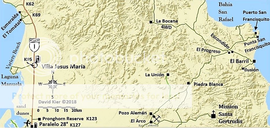
If you are wondering, "Variety Beach" is a nickname I was provided by Nomad 'Whistler', it is not on any 'official' maps. Both he and I fished that
beach in the 1980s and he told me his friends called it that because of the great variety of fish landed there.
|
|
|
| Pages:
1
2 |


