| Pages:
1
2
3 |
David K
Honored Nomad

Posts: 64493
Registered: 8-30-2002
Location: San Diego County
Member Is Offline
Mood: Have Baja Fever
|
|
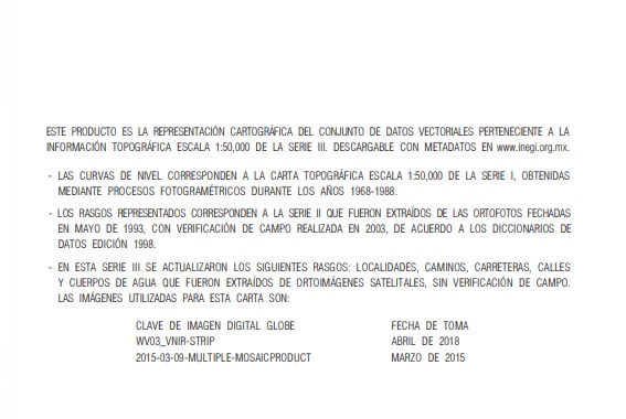
The INEGI link for PDF and GeoPDF maps is on my website, VivaBaja.com:
Mexican Topographic Maps from INEGI
(choose scale, area, and click PDF or GeoPDF where available)
Link: https://www.inegi.org.mx/temas/topografia/
|
|
|
WideAngleWandering
Nomad
Posts: 390
Registered: 3-13-2012
Location: US-Based but traveling
Member Is Offline
|
|
Wow this is great news!
While i have a GPS and I'm down for the occasional googlin', nothing beats pulling out a proper atlas to plan the next day's maneuvers or to swap
tips aroumd the campfire.
Traveling the Americas via my old land cruiser
|
|
|
geoffff
Senior Nomad
Posts: 644
Registered: 1-15-2009
Member Is Offline
|
|
Quote: Originally posted by PaulW  | Want PDF for maps?
Some years ago I went to the INEGI office in Mexicali and received a cd with the original maps (PDF). They appear to be what Landon used for his base
maps. I took the cd to a survey shop in Calexico and had several printed in color using the size of the original INEGI maps.
BTW, one can still go to the INEGI web site and download the appropriate maps one at a time. |
Nice! A couple years ago I download every single 50K INEGI map (there are about 2300 of them), and stitched them together into the seamless online
topographic maps you now see on the Caltopo website. 1600 of those INEGI maps are nice georeferenced digital PDFs, but the rest are a mishmash
various formats including rough scans of old paper maps.
-- Geoff
[Edited on 4-7-2021 by geoffff]
|
|
|
JZ
Elite Nomad
Posts: 9270
Registered: 10-3-2003
Member Is Offline
|
|
| Quote: Originally posted by WideAngleWandering |
While i have a GPS and I'm down for the occasional googlin', nothing beats pulling out a proper atlas to plan the next day's
maneuvers or to swap tips aroumd the campfire. |
Naw, this isn't true. Not at all in 2021.
An Atlas is a nice to have. If you have high res satellite images for all of Baja on every device (phone, tablet, etc.) of every person in your
group, combined with hundreds of tracks and way points you'd quickly understand the fallacy of that statement.
[Edited on 4-7-2021 by JZ]
|
|
|
David K
Honored Nomad
Posts: 64493
Registered: 8-30-2002
Location: San Diego County
Member Is Offline
Mood: Have Baja Fever
|
|
| Quote: Originally posted by geoffff | | Quote: Originally posted by PaulW | Want PDF for maps?
Some years ago I went to the INEGI office in Mexicali and received a cd with the original maps (PDF). They appear to be what Landon used for his base
maps. I took the cd to a survey shop in Calexico and had several printed in color using the size of the original INEGI maps.
BTW, one can still go to the INEGI web site and download the appropriate maps one at a time. |
Nice! A couple years ago I download every single 50K INEGI map (there are about 2300 of them), and stitched them together into the seamless online
topographic maps you now see on the Caltopo website. 1600 of those INEGI maps are nice georeferenced digital PDFs, but the rest are a mishmash
various formats including rough scans of old paper maps.
-- Geoff
[Edited on 4-7-2021 by geoffff] |
The CalTopo link is on VivaBaja.com:
>>Baja California, Mexico 'Zoom-In' Topo & Satellite Map<<
https://caltopo.com/map.html (takes you to the center of the peninsula)
|
|
|
WideAngleWandering
Nomad
Posts: 390
Registered: 3-13-2012
Location: US-Based but traveling
Member Is Offline
|
|
| Quote: |
An Atlas is a nice to have |
I use both. All these tools are nice to haves imo. It doesnt really matter though as this is not a competition.
Thanks davidk for the good news.
[Edited on 2021-4-7 by WideAngleWandering]
Traveling the Americas via my old land cruiser
|
|
|
geoffff
Senior Nomad
Posts: 644
Registered: 1-15-2009
Member Is Offline
|
|
| Quote: Originally posted by WideAngleWandering | Wow this is great news!
While i have a GPS and I'm down for the occasional googlin', nothing beats pulling out a proper atlas to plan the next day's maneuvers or to swap
tips aroumd the campfire. |
True - I love my computer, but a paper atlas is nice for general planning and sharing ideas with friends.
|
|
|
geoffff
Senior Nomad
Posts: 644
Registered: 1-15-2009
Member Is Offline
|
|
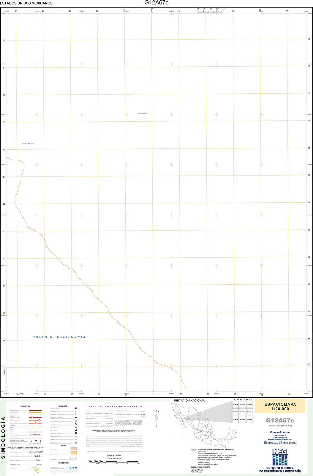
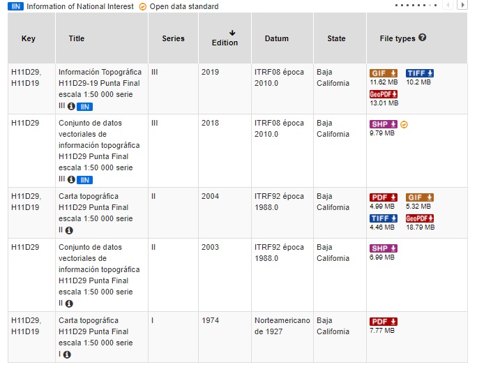
INEGI has a 20K map series as well. I had to remind myself just now why I had decided to work with INEGI's 50K maps instead. If you're curious --
INEGI's 20k series is hit & miss. Some 20K maps are excellent, while others are empty except for single coastline line.
|
|
|
geoffff
Senior Nomad
Posts: 644
Registered: 1-15-2009
Member Is Offline
|
|
The seem to be continuously working on them. I haven't checked back in on the 50K maps in a couple years, but the best of the 20K maps I showed above
is dated 2020.
|
|
|
David K
Honored Nomad
Posts: 64493
Registered: 8-30-2002
Location: San Diego County
Member Is Offline
Mood: Have Baja Fever
|
|
Curious if they show the new Hwy. 5 (Coco's bypass) work/ completed?
|
|
|
PaulW
Ultra Nomad
Posts: 3009
Registered: 5-21-2013
Member Is Offline
|
|
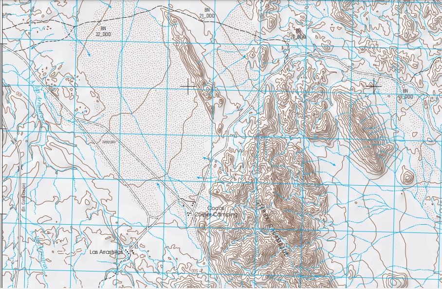
Looking for new Road
Punta Final H11D29-19
At least on this ,map the new road is shown, But I did not look at other maps
Search Results
Map Sidebar
Piece of the map
[Edited on 4-7-2021 by PaulW]
[Edited on 4-8-2021 by BajaNomad]
[Edited on 4-8-2021 by PaulW]
|
|
|
PaulW
Ultra Nomad
Posts: 3009
Registered: 5-21-2013
Member Is Offline
|
|
Las Astarissas
Looking at H11D29 PDFs
The 2004 INEGI map shows two buildings at Las Arrastritas
The 2018 INEGI map shows five buildings.
David’s placement at Km179.5 it is way different than the INEGI maps
What is the explanation?
I was told once that water is available at the INEGI location near the old Coco place where the buildings are situated.
|
|
|
David K
Honored Nomad
Posts: 64493
Registered: 8-30-2002
Location: San Diego County
Member Is Offline
Mood: Have Baja Fever
|
|
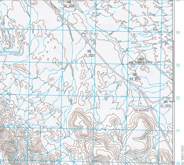
The place called Las Arrastritas (not Arrastras) on that map is the rancho on the old old (pre-1982) road where Coco's stand-by helper comes from (and
his source of water).
Las Arrastras is off the map above... where the new highway splits away from the older roads south.
|
|
|
David K
Honored Nomad
Posts: 64493
Registered: 8-30-2002
Location: San Diego County
Member Is Offline
Mood: Have Baja Fever
|
|
The new road (hwy) IS on that map!
|
|
|
geoffff
Senior Nomad
Posts: 644
Registered: 1-15-2009
Member Is Offline
|
|
| Quote: Originally posted by lencho | All of us who use maps based on INEGI products (as most Baja maps are), let's take a moment of silence to appreciate that huge amount of work that we
can make use of, usually free.
Count it among the things the Mexican Government has done well. |
I'm very appreciative!
My understanding is that it wasn't until 2014 that INEGI put the maps into public domain for free copying.
https://www.nosolosig.com/noticias/428-el-inegi-emite-norma-...
https://goo.gl/hjEcbP (Google translation of above)
Many governments don't freely give out their maps. United Kingdom, for example.
|
|
|
PaulW
Ultra Nomad
Posts: 3009
Registered: 5-21-2013
Member Is Offline
|
|
Agree - INEGI is first class
And the effort continues to replace my 2004 PDF versions with 2018 PDF versions.
I am sure I will deal with updating when time allows.
I guess I have to look at them one at a time to find the new ones?
Do you have a list of the ones that are updated?
|
|
|
mtgoat666
Select Nomad
Posts: 17344
Registered: 9-16-2006
Location: San Diego
Member Is Offline
Mood: Hot n spicy
|
|
| Quote: Originally posted by PaulW | Agree - INEGI is first class
And the effort continues to replace my 2004 PDF versions with 2018 PDF versions.
I am sure I will deal with updating when time allows.
I guess I have to look at them one at a time to find the new ones?
Do you have a list of the ones that are updated?
|
you can download the INEGI top maps here: https://www.inegi.org.mx/temas/topografia/
For each map, you have choice of format (tiff, gif, pdf, geo-pdf formats depending on date and location) and date/version, so can pick and choose
which date map you want.
Woke!
“...ask not what your country can do for you – ask what you can do for your country.” “My fellow citizens of the world: ask not what America
will do for you, but what together we can do for the freedom of man.”
Prefered gender pronoun: the royal we
|
|
|
motoged
Elite Nomad
Posts: 6481
Registered: 7-31-2006
Location: Kamloops, BC
Member Is Offline
Mood: Gettin' Better
|
|
Great sources.
But ... "the map is not the territory " 
Interesting:
https://www.cnn.com/travel/article/bronze-age-slab-map-intl-scli-scn/index.html
[Edited on 4-9-2021 by motoged]
[Edited on 4-9-2021 by motoged]
Don't believe everything you think....
|
|
|
motoged
Elite Nomad
Posts: 6481
Registered: 7-31-2006
Location: Kamloops, BC
Member Is Offline
Mood: Gettin' Better
|
|
I usually do that....my apologies and appreciation for the fix. 
I corrected my post.
[Edited on 4-9-2021 by motoged]
Don't believe everything you think....
|
|
|
PaulW
Ultra Nomad
Posts: 3009
Registered: 5-21-2013
Member Is Offline
|
|
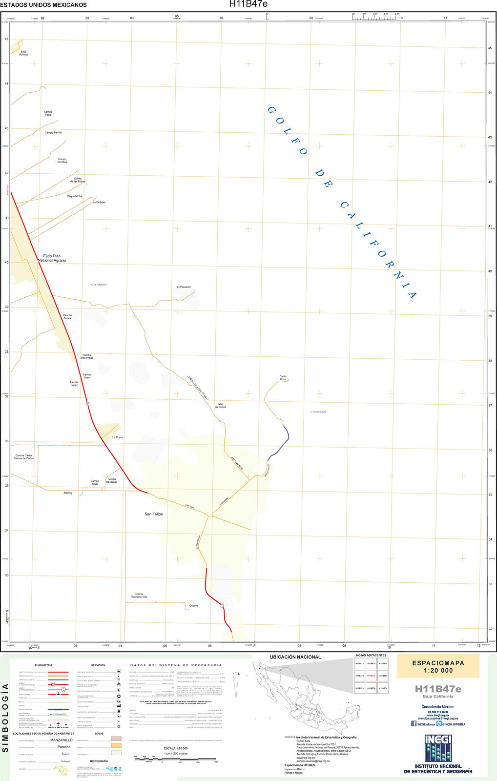
INEGI PDFs
All the INEGI 2018 maps now show the new Hwy5 to Chapala
Here are the INEGI PDFs I checked
Order Chapala north
H11D38 Chapala
H11D29 Punta Final
H11D28 Jaraquay
H11D18 Isla San Luis
H11B88 Huerfinito
H11B87 Cerro el Huerfinito
H11B77-78 Puertictos
H11B67-68 Santa Maria
H11 B57 Punta Estrella
H11B47 San Felipe
Here is the turn to Coco on map H11D28
|
|
|
| Pages:
1
2
3 |