| Pages:
1
2 |
HeyMulegeScott
Senior Nomad

Posts: 690
Registered: 8-25-2009
Location: Orygone/Mulege
Member Is Offline
|
|
Using Garmin Inreach in Baja
I picked a Garmin InReach Explorer+ this summer and really it. I was wondering in Baja if we needed non-emergency assistance if there is a list of
numbers I can give someone in the US to contact for me once I use the Garmin to email or text them.
FYI Costco has the base model on sale for $229.
|
|
|
mtgoat666
Select Nomad
Posts: 17295
Registered: 9-16-2006
Location: San Diego
Member Is Offline
Mood: Hot n spicy
|
|
Quote: Originally posted by Three2tango  | I picked a Garmin InReach Explorer+ this summer and really it. I was wondering in Baja if we needed non-emergency assistance if there is a list of
numbers I can give someone in the US to contact for me once I use the Garmin to email or text them.
FYI Costco has the base model on sale for $229. |
What kind of non-emergency assistanc do u need?
Call your mom!
Woke!
“...ask not what your country can do for you – ask what you can do for your country.” “My fellow citizens of the world: ask not what America
will do for you, but what together we can do for the freedom of man.”
Prefered gender pronoun: the royal we
|
|
|
ehall
Super Nomad
Posts: 1906
Registered: 3-29-2014
Location: Buckeye, Az
Member Is Offline
Mood: It's 5 o'clock somewhere
|
|
Maybe if you know someone that lives there and could make calls for you.
|
|
|
HeyMulegeScott
Senior Nomad
Posts: 690
Registered: 8-25-2009
Location: Orygone/Mulege
Member Is Offline
|
|
| Quote: Originally posted by mtgoat666 | | Quote: Originally posted by Three2tango | I picked a Garmin InReach Explorer+ this summer and really it. I was wondering in Baja if we needed non-emergency assistance if there is a list of
numbers I can give someone in the US to contact for me once I use the Garmin to email or text them.
FYI Costco has the base model on sale for $229. |
What kind of non-emergency assistanc do u need?
Call your mom!
|
I'm guessing this isn't a serious response but OK is there a number for the Green Angels or similar my Mom or someone in the US could call if we
needed roadside assistance? I know the State of Baja California has the 078 number you can call from a cell in Baja.
|
|
|
carlosg
Senior Nomad
Posts: 504
Registered: 5-28-2012
Location: chula vista, ca
Member Is Offline
Mood: Just like in Baja: No Bad Days...
|
|
Costco: Garmin inReach SE+ Satellite Communicator https://www.costco.com/Garmin-inReach-SE%2b-Satellite-Commun...
We'll be taking a trip in a few days and I'll be bringing along the Explorer+, one of the contacts I'll have handy is the Towing
Service in Punta Prieta Whatsapp number: (011 52) 1 616-117-3592, Luis Lopez, Spanish only (I think) ....
just in case... DON'T forget your Insurance Company cell number... Baja Bound... anyone that you can text...
[Edited on 9-15-2018 by carlosg]
|
|
|
PaulW
Ultra Nomad
Posts: 3005
Registered: 5-21-2013
Member Is Offline
|
|
Just make sure you have a local in your contact list. Don't plan on using text, use email. If you do not know anyone in Baja that could help then you
are screwed. Of course there are many full timers in various locations throughout Baja. Choose a specific area and ask for their contact info on this
forum.
======== =
| Quote: Originally posted by Three2tango | | I picked a Garmin InReach Explorer+ this summer and really it. I was wondering in Baja if we needed non-emergency assistance if there is a list of
numbers I can give someone in the US to contact for me once I use the Garmin to email or text them. |
|
|
|
David K
Honored Nomad
Posts: 64479
Registered: 8-30-2002
Location: San Diego County
Member Is Offline
Mood: Have Baja Fever
|
|
As PaulW knows (for he was once the rescue wagon), I have had Nomads with Spot or inReach devices notify me if they need assistance, and since I am on
this website way too much, I am often good to get the word out should anyone of you be able to help! Graham, Mike Younghusband, Pappy Jon, and Geoffff
come to mind.
I can tell you from traveling in Baja solo for 7 of 12 months, in 2017, and once last month, that it is very comforting to know you have friends and
family who you can text or email with and they can see your location. Stuck Sucks would often text me while I was on a trip to help me if I seemed to
be on a dead-end road or I could ask him a question about a road, as he travels so much for Cops Racing Team.
-----------------------------------------------------------------------------
I had use of a Garmin/DeLorme inReach Explorer for my Baja Bound research trips. It also doubles as a map making device and can record waypoints for
points of interest. I think I have recorded about 1,000 so far for Baja Bound!
|
|
|
HeyMulegeScott
Senior Nomad
Posts: 690
Registered: 8-25-2009
Location: Orygone/Mulege
Member Is Offline
|
|
Thanks, guys. Good suggestions minus the one from the goat guy. I was also looking at my yearly insurance policy from ACE we bought through Discover
Baja that includes "Platinum Travel Assitance" I need to get more information on what that includes.
David K - How do you like the Garmin maps in Baja? I've been pretty impressed with the detail in the NW this summer.
|
|
|
David K
Honored Nomad
Posts: 64479
Registered: 8-30-2002
Location: San Diego County
Member Is Offline
Mood: Have Baja Fever
|
|
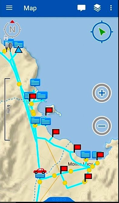
The maps on the inReach are fine for seeing where you are in relation to the coast or main roads. I have posted a couple of samples. Not sure if they
are 'Garmin' maps, as the inReach I used was still by DeLorme, but Garmin had just bought DeLorme.
Here is the screen, on my smartphone of the inReach map, Gonzaga Bay. The red flags are waypoints and the blue text boxes are message points, verticle
and horizontal:
-----------------------------------------------------------------------------------------------------------------------
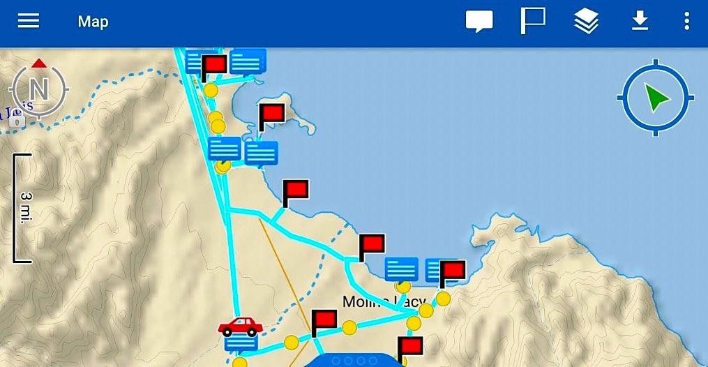
On the website map page after your trip, further south, here:
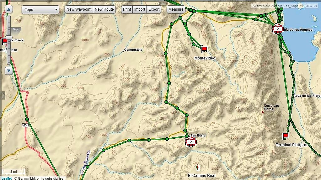
Here is a sample of the San Borja/ L.A. Bay area with some of my tracks on it. I have not mastered how to display tracks at a consistent sending
interval. Some are at 1 min. and some are at 10 min. Also, some extra straight-across tracks connect message points that do not represent where I was
driving closely. I think the trick to that is to turn off tracking each night?
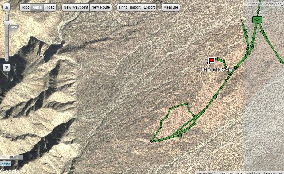
Here is near the terminal platform south of Las Flores, and you can see you can view a satellite image as well as a topo map.
|
|
|
Alm
Ultra Nomad
Posts: 2716
Registered: 5-10-2011
Member Is Offline
|
|
You better watch out, goat, people without sense of humor can be dangerous 
Cell phone, Green Angels, roadside assistance.... Wake up, there is no such thing once you leave Tijuana-Ensenada area. Well, you might get cell
phone service once you get to some town - but then they will take care of your non-emergency needs too, whatever it is. Beware of car-towing
services. And of local police too.
|
|
|
HeyMulegeScott
Senior Nomad
Posts: 690
Registered: 8-25-2009
Location: Orygone/Mulege
Member Is Offline
|
|
David K - You are correct about the Delorme maps still being used by the InReach line.
Those 10min intervals do look a little wonky. Probably a good idea to turn off the tracking when you're done for the day.
|
|
|
John Harper
Super Nomad
Posts: 2289
Registered: 3-9-2017
Location: SoCal
Member Is Offline
|
|
I think he's "fearless" because the only weapon they have is a keyboard.
John
|
|
|
mtgoat666
Select Nomad
Posts: 17295
Registered: 9-16-2006
Location: San Diego
Member Is Offline
Mood: Hot n spicy
|
|
The pen is mightier than the sword
Woke!
“...ask not what your country can do for you – ask what you can do for your country.” “My fellow citizens of the world: ask not what America
will do for you, but what together we can do for the freedom of man.”
Prefered gender pronoun: the royal we
|
|
|
John Harper
Super Nomad
Posts: 2289
Registered: 3-9-2017
Location: SoCal
Member Is Offline
|
|
Then I guess you fall into the category of "an unarmed man."
John
|
|
|
PaulW
Ultra Nomad
Posts: 3005
Registered: 5-21-2013
Member Is Offline
|
|
| Quote: Originally posted by Three2tango | David K - You are correct about the Delorme maps still being used by the InReach line.
Those 10min intervals do look a little wonky. Probably a good idea to turn off the tracking when you're done for the day. |
======= =
Yup, The 10 min is the default for sending a link to others. Like David said after your trip go to your account and get a better track/map. Lately I
have been using a 2 second track point interval and I get great tracks. Even with a specific track point like 2 sec you always get a 10 min map for
the default to send to others. The only issue with a 2 sec choice is very large GPX files. With 2 sec you are limited to 2 days of continuous usage. I
just spent 3 days in Moab and my device was hardly filled with track points because I turned it off after each day trip.
Example of a 2 sec trip
Two different zoom levels.
Screen shots from my account:
 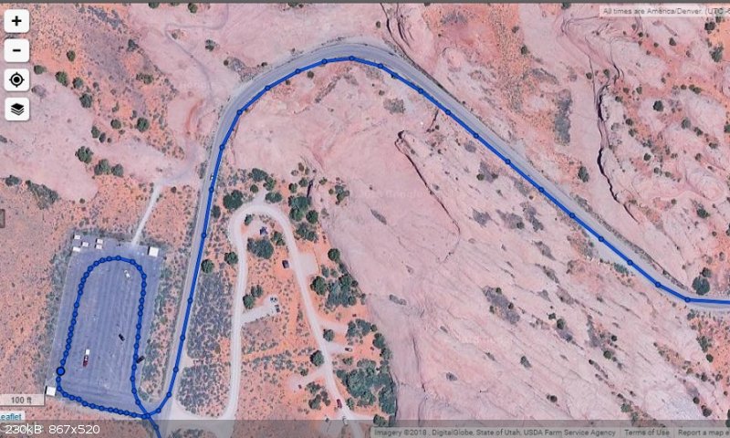
[Edited on 9-17-2018 by PaulW]
|
|
|
David K
Honored Nomad
Posts: 64479
Registered: 8-30-2002
Location: San Diego County
Member Is Offline
Mood: Have Baja Fever
|
|
Nice work Paul!!!
|
|
|
PaulW
Ultra Nomad
Posts: 3005
Registered: 5-21-2013
Member Is Offline
|
|
Thanks, That area zoomed way in is the parking lot where the trip leader gave his briefing.
InReach has good maps especially in the US. Not so good in Baja.
BTW, the new Spot device has the feature of shorter track point interval and SPOT has always had the ability to create KML and GPX tracks. Of course
the default of 10 minutes is much worse than InReach due to lower fidelity of the map.
A research study will have to be done to see is SPOT vs Inreach has the most cost effective accurate tracks. SPOT charges extra for more track
points. For several years both SCORE and NORRA use SPOT with increased track points
|
|
|
HeyMulegeScott
Senior Nomad
Posts: 690
Registered: 8-25-2009
Location: Orygone/Mulege
Member Is Offline
|
|
Paul W - Good to know on the tracking intervals. It would be nice if Garmin integrated InReach with their Basecamp desktop application so you could
download the tracks offline.
|
|
|
PaulW
Ultra Nomad
Posts: 3005
Registered: 5-21-2013
Member Is Offline
|
|
| Quote: Originally posted by Three2tango | | Paul W - Good to know on the tracking intervals. It would be nice if Garmin integrated InReach with their Basecamp desktop application so you could
download the tracks offline. |
===== =
Not fully integrated with Garmin. Now is take quite a few minutes to get the tracks loaded. Once you have the GPX file its ok. The Inreach device
data goes to the cloud then to your account then to a GPX file. Not a great way to do it.
No way to link the device data to a computer file like Basecamp.
|
|
|
kevin_in_idaho
Nomad
Posts: 143
Registered: 12-13-2016
Member Is Offline
|
|
We just got a garmin "mini" and will be using it starting in Dec/Jan for an extended road trip into Mexico. I'll be curious to see how it works for
people to track us. We got it mainly for the texting availability and for emergencies if we are "off the beaten path".
We'll get the 40 text message plan and if anyone has recommendations on what settings, etc. are critical, please let me know!
Thanks!
|
|
|
| Pages:
1
2 |


