| Pages:
1
2
3
4
5 |
John M
Super Nomad

Posts: 1906
Registered: 9-3-2003
Location: California High Desert
Member Is Offline
|
|
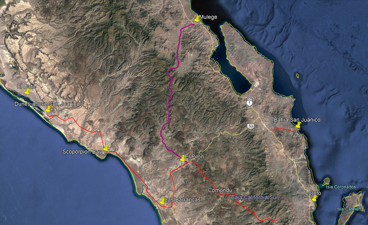
tracks?
AV - I don't have a GPS track but I think if I go out to my truck GPS I may have a couple of dozen waypoints - there are a couple of places to go off
on your own adventure. If I have them, and can download them, I will send you a U2U and get an email address.
John M
|
|
|
John M
Super Nomad
Posts: 1906
Registered: 9-3-2003
Location: California High Desert
Member Is Offline
|
|
avrider
Kurt G's route and notes are right on the money. His descriptions of the difficult sections was pretty much as we found it two years ago except we did
it in the reverse direction, Mulege to San Isidro. I have some additional way points that can supplement Kurt's directions but they don't change
anything. I will say that going Mulege to San Isidro there are two, maybe three intersecting ranch roads that will take you off in the wrong direction
before the rough stuff even starts. I plotted those, and have the gps coordinates. As Kurt drove it, those intersections probably wouldn't even be
worth mentioning. I did make a track in Google Earth following his directions and using some of my waypoints and can convert it to KML file if you'd
like to see it.
John M
|
|
|
David K
Honored Nomad
Posts: 64479
Registered: 8-30-2002
Location: San Diego County
Member Is Offline
Mood: Have Baja Fever
|
|
Kurt's Road Log (edited version)
Quote: Originally posted by KurtG  |
Here is my report from March 2012:
Trip Report/road log San Isidro-Mulege Mountain Route 3/22/2012
For reference our vehicle is a 2000 Explorer stock Bauer Ed. with 255/70/16 Michelin street tires run at about 22#.
The report is a mileage log and includes GPS data and elevation for key points. The log is as accurate as Garmin and Ford's odometer could provide.
Mile Zero is starting North from San Isidro at 26.12.866x112.01.577.
Excellent road to:
Mile 12.3 Purisima Vieja then to
Mile 15.4 Paso Hondo. Both are oasis villages with some great scenery.
Mile 17.8-Springs and ponds on left.
Mile 18.3-Small village.
Mile 21.2-water crossing/palms and on to Buenos Aires at mile 25.9.
Mile 29.1-Agua Grande
Mile 32.2. 26.32.962x112.06.834. Elev.2100. Sign: El Llano straight, Guajadami to the right. Go straight.
From here the road is steep and rocky with a lot of erosion. Low range used to:
Mile 36.7 the top of high plateau. Elev. 3350 at 26.35.899x112.07.222.
Mile 37. Incredible views of deep gorge on right. Continue to climb to:
Mile 39.1. 26.37.146x112.06.743. Elev. 3765. High point overlooking the broad expanse of El Llano below.
This is where the road ended when I attempted this route some 15 years ago. The descending cuesta was the most difficult of the entire trip. Steep,
sometimes narrow and off camber and rough eroded rock with lots of loose stuff. This is an area to use extreme caution. We crept down in low
range, 1st gear to arrive in the flats of El Llano at:
Mile 40.6. 26.37.786x112.07.153. Elev. 2616.
At this point we met a rancher with a Ford F350 4wd and a cattle rack who had 3-4 cattle loaded. We told him we were going to Mulege and he said he
was as well. That gave us a better feeling about actually completing the trip since I didn’t feel we could climb back up that previous cuesta or at
least really didn’t want to attempt it. He confirmed that that plateau is El Llano. As we started up the next grade we saw him starting behind us.
A rough ride for those cows! The road continues up and down a bit before a gate at the top of the final cuesta at:
Mile 43.1. 26.39.029x112.08.07. Elev. 3429. Now down the cuesta, steep and rough but not nearly as bad as the earlier one. There has been traffic
up and down this area since we were on it and turned back a few months ago. I think we could now go up this one ok.
Mile 46.2. 26.40.320x112.07.130. elev. 1346. This position is right by the ranch at the bottom of the cuesta. Rancho El Llanito. It is relatively
new. This is the important coordinate for anyone doing this trip north to south since it is not shown on the maps and in my experience the Baja Atlas
and other maps are only an approximation of the roads in this area.
From this point you are on the road that goes straight to Mulege. There are occasional roads that come in from both side notably at:
Mile 50.8 which has a sign pointing back to Rcho El Llanito. I believe the other fork here leads to the area of El Potrero and El Batiqui and Pia de
la Cuesta Guajadami. I have motorcycled in that area but not since the hurricanes changed some of the roads a few years ago. Note that I have not
called this the Guajadami Road since it splits off from the old mission route and is generally to the west of it.
Continue straight into Mulege arriving at Hwy 1 (icehouse road junction) at MILE 67.3.
This trip took about 6 hours so an average speed of about 10 mph. Thanks to Mulegena for the trip report on Baja Nomads that inspired us to do this
trip. The scenery was wonderful although I would still rank the San Juan de la Pila road as the slightly more spectacular but I am really splitting
hairs on that call. Do them both and tell me what you think!
Kurt and Kathy, March 22, 2012 |
Kurt, I hope it is okay with you that I played/edited with your log a bit! 
|
|
|
advrider
Super Nomad
Posts: 1847
Registered: 10-2-2015
Member Is Offline
|
|
The trip log is awesome but harder to use on a moto. John M, If you could make the KML file that would be great. I try to plan my rides out the best I
can with tracks/routes before we go, just because it's a large time investment just getting to Baja and getting the time off. I don't mind wondering
around Baja but like to manage my ride time the best I can. Thanks to everyone that shares all of the info that makes exploring Baja so much easier
and funner!
|
|
|
John M
Super Nomad
Posts: 1906
Registered: 9-3-2003
Location: California High Desert
Member Is Offline
|
|
KML
avrider - do you have some thought as to which direction you will be riding?
I have a few added notes to what Kurt wrote and David edited, but as I said south to north and his notes are fine. Also when I made the gps file today
there were a couple of sections that on Google Earth could present an "either/or" decision, however as usually happens both choices do come back
together.
I will try to attach it here. If I can't get it to attach I will send you a U2U for an email address.
John
Attachment: Kurt & Kathy San Isidro to Mulege.kml (36kB)
This file has been downloaded 236 times
|
|
|
advrider
Super Nomad
Posts: 1847
Registered: 10-2-2015
Member Is Offline
|
|
Most likely North to South but I'm not sure yet? Thanks again
|
|
|
JZ
Elite Nomad
Posts: 9226
Registered: 10-3-2003
Member Is Offline
|
|
| Quote: Originally posted by John M | avrider - do you have some thought as to which direction you will be riding?
I have a few added notes to what Kurt wrote and David edited, but as I said south to north and his notes are fine. Also when I made the gps file today
there were a couple of sections that on Google Earth could present an "either/or" decision, however as usually happens both choices do come back
together.
I will try to attach it here. If I can't get it to attach I will send you a U2U for an email address.
John
|
Awesome. Loads straight into GE. That's the way you do it!
That looks like one bad ass trip.
[Edited on 9-28-2018 by JZ]
|
|
|
TMW
Select Nomad
Posts: 10659
Registered: 9-1-2003
Location: Bakersfield, CA
Member Is Offline
|
|
If you do the Mulege to San Isidro route you can make a loop out of it by coming back by way of the San Raymundo trail.
|
|
|
AKgringo
Elite Nomad
Posts: 5806
Registered: 9-20-2014
Location: Anchorage, AK (no mas!)
Member Is Online
Mood: Retireded
|
|
It will be interesting to see if any of the central Baja trails are passable after the two tropical disturbances in the forecast
figure out where they are going to come ashore!
By the end of next week, I suspect there will be a lot of road/trail updates that will need to be posted. Hopefully the track will continue to move
further to the west!
If you are not living on the edge, you are taking up too much space!
"Could do better if he tried!" Report card comments from most of my grade school teachers. Sadly, still true!
|
|
|
advrider
Super Nomad
Posts: 1847
Registered: 10-2-2015
Member Is Offline
|
|
| Quote: Originally posted by TMW | | If you do the Mulege to San Isidro route you can make a loop out of it by coming back by way of the San Raymundo trail. |
Anymore info on this trail? A loop would be very cool... We are looking at March if you want to lead the ride?
|
|
|
advrider
Super Nomad
Posts: 1847
Registered: 10-2-2015
Member Is Offline
|
|
John M thanks for the KML, I can convert that to a GPS track. That looks like it will be a cool new route to try out in March...
|
|
|
JZ
Elite Nomad
Posts: 9226
Registered: 10-3-2003
Member Is Offline
|
|
| Quote: Originally posted by advrider | | John M thanks for the KML, I can convert that to a GPS track. That looks like it will be a cool new route to try out in March...
|
How fast do you think you could rip through it on your bikes?
[Edited on 9-28-2018 by JZ]
|
|
|
TMW
Select Nomad
Posts: 10659
Registered: 9-1-2003
Location: Bakersfield, CA
Member Is Offline
|
|
The switchbacks and rocks will slow you down.
|
|
|
TMW
Select Nomad
Posts: 10659
Registered: 9-1-2003
Location: Bakersfield, CA
Member Is Offline
|
|
| Quote: Originally posted by advrider | | Quote: Originally posted by TMW | | If you do the Mulege to San Isidro route you can make a loop out of it by coming back by way of the San Raymundo trail. |
Anymore info on this trail? A loop would be very cool... We are looking at March if you want to lead the ride? |
Here is the loop using the almanac. I can trace it on Google Earth for a GPS track.

[Edited on 9-28-2018 by TMW]
|
|
|
motoged
Elite Nomad
Posts: 6481
Registered: 7-31-2006
Location: Kamloops, BC
Member Is Offline
Mood: Gettin' Better
|
|
| Quote: Originally posted by JZ |
How fast do you think you could rip through it on your bikes?
[Edited on 9-28-2018 by JZ] |
Several years ago some friends left Mulege in the morning and slept in Loreto that evening....going through Commondu: "A" riders...
Don't believe everything you think....
|
|
|
JZ
Elite Nomad
Posts: 9226
Registered: 10-3-2003
Member Is Offline
|
|
| Quote: Originally posted by motoged |
Several years ago some friends left Mulege in the morning and slept in Loreto that evening....going through Commondu: "A" riders...
|
Where's the pic of the broken leg??
|
|
|
advrider
Super Nomad
Posts: 1847
Registered: 10-2-2015
Member Is Offline
|
|
Coming out of scorpion bay I would plan it for a day ride just to be safe. I like to finish before dark and not cut into my beer time! Plus I think
the views would be awesome so I wouldn't want to be in a rush.
|
|
|
KurtG
Super Nomad
Posts: 1201
Registered: 1-27-2004
Location: California Central Coast
Member Is Offline
Mood: Press On Regardless!!
|
|
| Quote: Originally posted by advrider | | Coming out of scorpion bay I would plan it for a day ride just to be safe. I like to finish before dark and not cut into my beer time! Plus I think
the views would be awesome so I wouldn't want to be in a rush. |
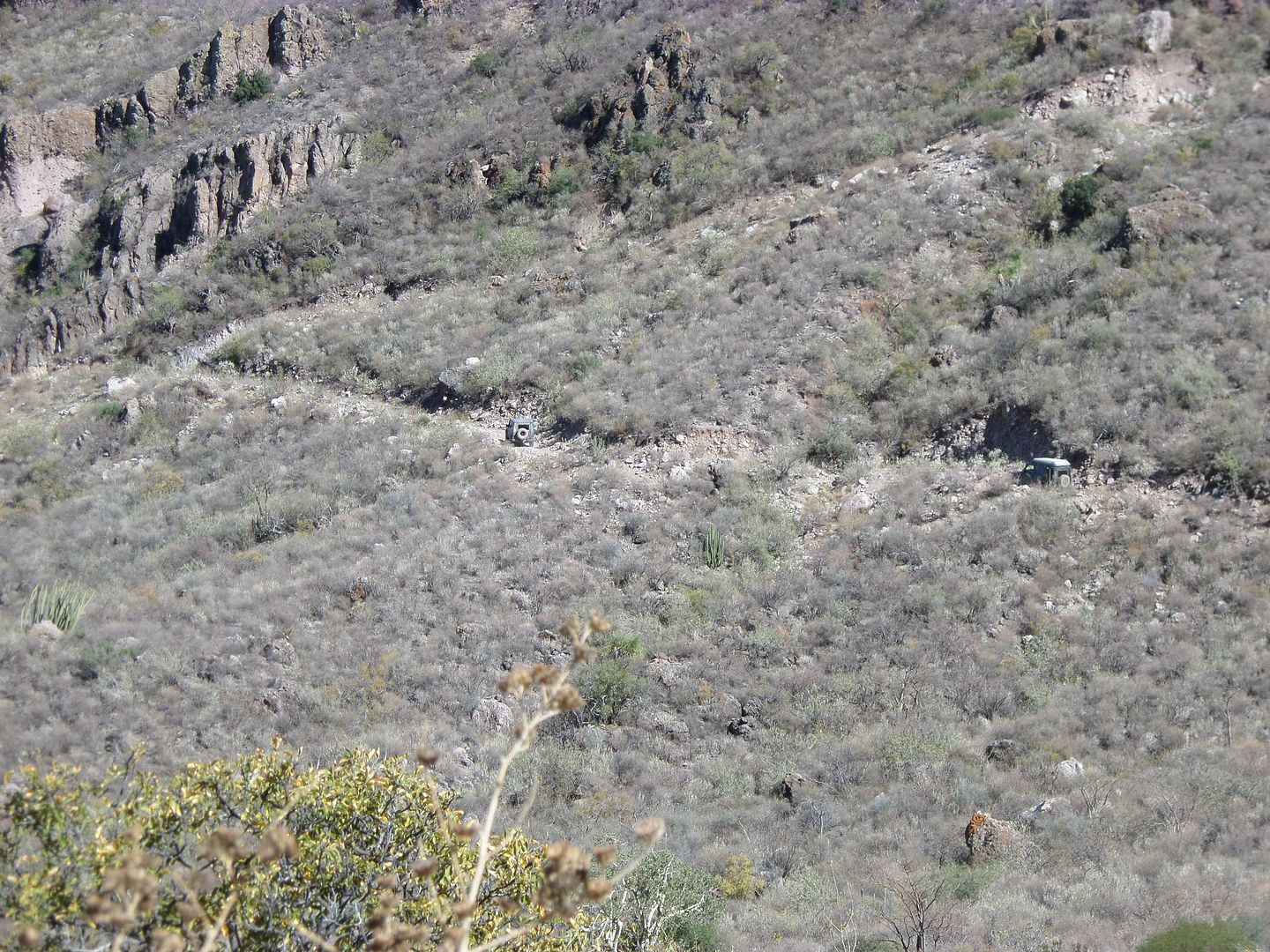
Stopping for the view at Mile 37, going North, is a must. Spectacular.
|
|
|
John M
Super Nomad
Posts: 1906
Registered: 9-3-2003
Location: California High Desert
Member Is Offline
|
|
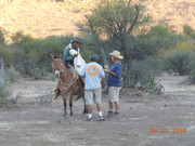
Views
There are many places to stop and take it all in. The view Kurt is talking about is outstanding.
At Kurt's mile 40.6 - El Llano valley - where he met the cowboy is also the very spot a cowboy came up and met us - we were setting up camp for the
night. There was yet another post some time ago from another group passing the same place where they also encountered a local.
John M
You can click on the photo to enlarge it. Still don't have the NOMAD way to post figured out.
[Edited on 9-28-2018 by John M]
|
|
|
TMW
Select Nomad
Posts: 10659
Registered: 9-1-2003
Location: Bakersfield, CA
Member Is Offline
|
|
Beautiful country for sure.


|
|
|
| Pages:
1
2
3
4
5 |


