| Pages:
1
2
3
4
5 |
David K
Honored Nomad

Posts: 64479
Registered: 8-30-2002
Location: San Diego County
Member Is Offline
Mood: Have Baja Fever
|
|
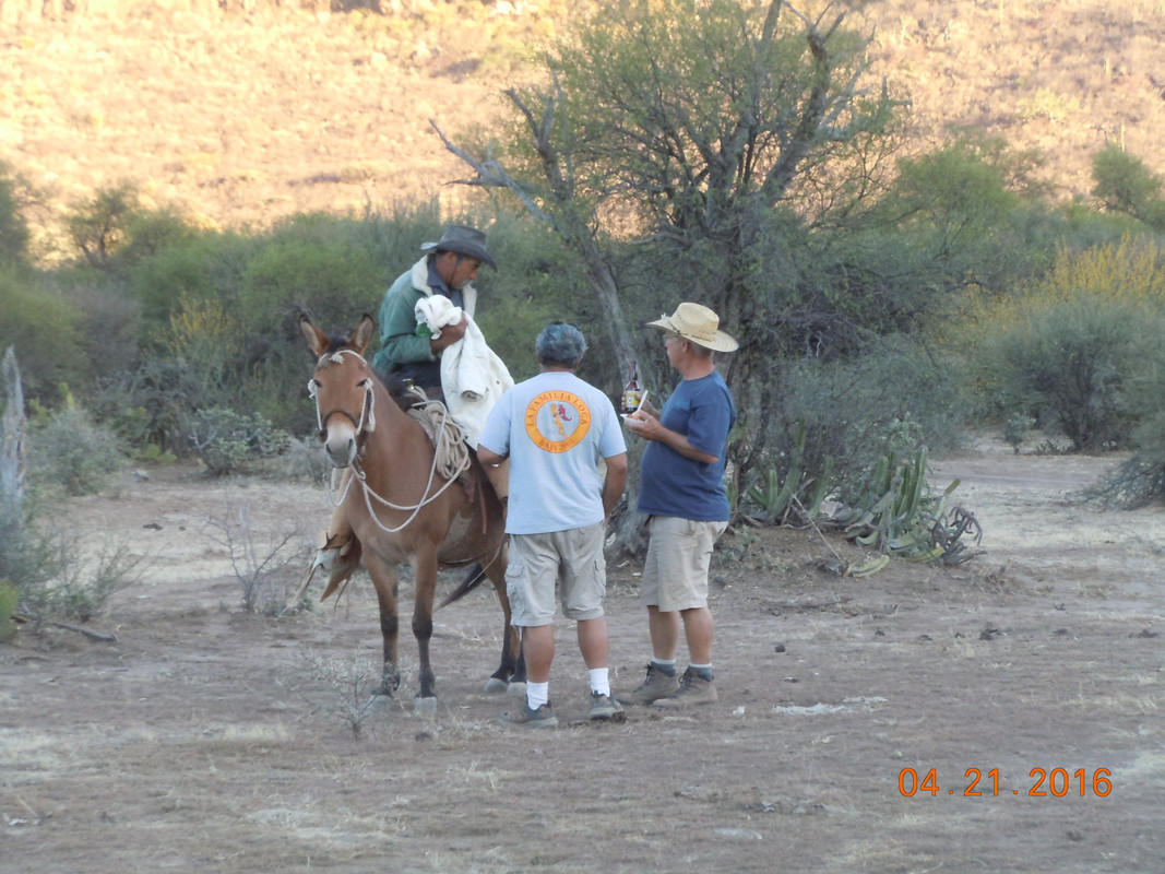
Quote: Originally posted by John M  | There are many places to stop and take it all in. The view Kurt is talking about is outstanding.
At Kurt's mile 40.6 - El Llano valley - where he met the cowboy is also the very spot a cowboy came up and met us - we were setting up camp for the
night. There was yet another post some time ago from another group passing the same place where they also encountered a local.
John M
You can click on the photo to enlarge it. Still don't have the NOMAD way to post figured out.

[Edited on 9-28-2018 by John M] |
John, on PostImage click Share then click the "hotlink for forums" however you missed the upload setting when you first got onto PostImage... You need
to set it at 800 pixels. I edited it here...
|
|
|
advrider
Super Nomad
Posts: 1847
Registered: 10-2-2015
Member Is Offline
|
|
I posted in another thread on here but this is the one I should have used. I have a track someone gave me called Mulege mountain track, I will see if
I can post it!
let me know if anyone has run this track? I haven't tried to put it on google earth yet either...
Attachment: San Ignacio to Mulege Mountain track.gpx (22kB)
This file has been downloaded 213 times
[Edited on 9-29-2018 by advrider]
|
|
|
JZ
Elite Nomad
Posts: 9226
Registered: 10-3-2003
Member Is Offline
|
|
| Quote: Originally posted by advrider | I posted in another thread on here but this is the one I should have used. I have a track someone gave me called Mulege mountain track, I will see if
I can post it!
let me know if anyone has run this track? I haven't tried to put it on google earth yet either...
|
Here's that track.
|
|
|
John M
Super Nomad
Posts: 1906
Registered: 9-3-2003
Location: California High Desert
Member Is Offline
|
|
San Ignacio to Mulege Mountain route
Here is JZ's route in KML for Google Earth. Well, it was my intent to post it!
I converted it to a KML file and realized that for some reason the KML won't let me copy & paste. I have had this issue before, and If I recall
correctly I can paste a KMZ file. Now I can't make this kml into a kmz. I can view it on G.E. however.
All that said, this appears to be the same route (with a few little variations) TW, myself, and a couple of others were intending to try in 2016 -
This is the route for which TW had spoken with Blanca about and was told that it was absolutely impassable for 4x4s, according to a rancher that lived
"at the end of the road."
JM
|
|
|
advrider
Super Nomad
Posts: 1847
Registered: 10-2-2015
Member Is Offline
|
|
Well maybe I can put both tracks together and make a loop out of it when I go in March? Does anyone have another track that they know will go through
to make it a full loop ending back in San Ignacio?
|
|
|
JZ
Elite Nomad
Posts: 9226
Registered: 10-3-2003
Member Is Offline
|
|
| Quote: Originally posted by John M | Here is JZ's route in KML for Google Earth. Well, it was my intent to post it!
I converted it to a KML file and realized that for some reason the KML won't let me copy & paste. I have had this issue before, and If I recall
correctly I can paste a KMZ file. Now I can't make this kml into a kmz. I can view it on G.E. however.
All that said, this appears to be the same route (with a few little variations) TW, myself, and a couple of others were intending to try in 2016 -
This is the route for which TW had spoken with Blanca about and was told that it was absolutely impassable for 4x4s, according to a rancher that lived
"at the end of the road."
JM
|
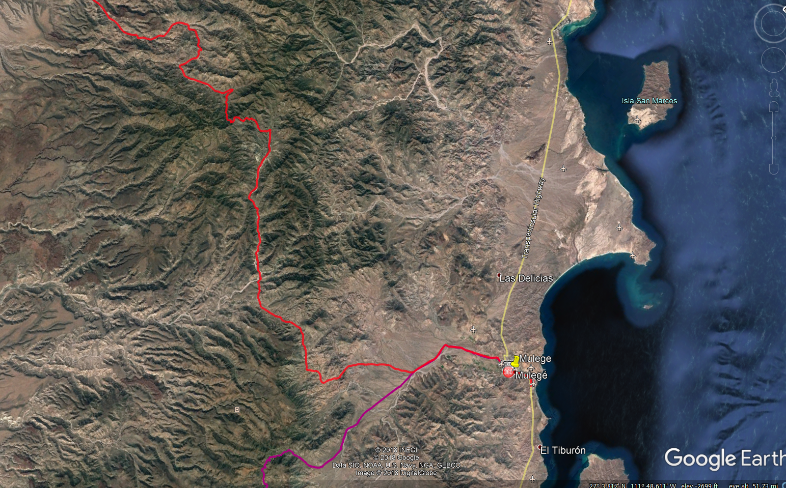
Here it is as a KML. Long track - 121 miles.
Attachment: Rt San Ignaco to Mulege.kml (11kB)
This file has been downloaded 236 times
[Edited on 9-29-2018 by JZ]
|
|
|
MulegeAL
Nomad
Posts: 298
Registered: 8-25-2009
Location: PDX/Mulege
Member Is Offline
|
|
| Quote: Originally posted by willyAirstream |
Off topic, but of interest, I am sure. Folks in San Jose de Mag say the route to Guadalupe is now open, even graded. We are planning a trip Oct 6th
and I will post. |
That would be great news if true, looking fwd to your trip report on that route!
|
|
|
Jinete Viejo
Junior Nomad
Posts: 88
Registered: 1-23-2017
Member Is Offline
|
|
I think there was a thread on this blog that showed guys pushing and carrying their bikes on what is the blue line on the map JZ posted above. Maybe
the info in willyAirstream's post changed that? It will be interesting to see what advrider finds.
|
|
|
motoged
Elite Nomad
Posts: 6481
Registered: 7-31-2006
Location: Kamloops, BC
Member Is Offline
Mood: Gettin' Better
|
|
| Quote: Originally posted by willyAirstream | no recent news on the route to San Isidro, but....
Off topic, but of interest, I am sure. Folks in San Jose de Mag say the route to Guadalupe is now open, even graded. We are planning a trip Oct 6th
and I will post. |
Richard,
Does the route down to Magdelana go through the canyon again (that was east of the pass from San Estanaslo (sp?)/Guadalupe area?
Or do they have a new route from that pass area?
PS.. Hope all is well
Don't believe everything you think....
|
|
|
MulegeAL
Nomad
Posts: 298
Registered: 8-25-2009
Location: PDX/Mulege
Member Is Offline
|
|
Hey Ged! Good to see you are still typing and sucking air!
So waddaya think? Should we try that Mulege Mtn track that JZ posted?
That could be epic, or fatal. I got the range if we don't screw up on nav too much.
It'll have to be on your GPS. I still haven't replaced mine since slamming into that darned goat last year.
|
|
|
motoged
Elite Nomad
Posts: 6481
Registered: 7-31-2006
Location: Kamloops, BC
Member Is Offline
Mood: Gettin' Better
|
|
Al,
Which one....the one down to San Isidro....or the new one west of Magdelena?
I have done the one from San Ignacio on the 690 and am not in a hurry to do it again...would consider doing the one down to San Isidro....or at least
from Magdelena up to the pass north of Guadalupe....and back....an in and outer.
It would need to be early March for me...I am in Bahia Asuncion from November to at least end of February...with the 450.
How did the goat fare?
[Edited on 10-1-2018 by motoged]
Don't believe everything you think....
|
|
|
JZ
Elite Nomad
Posts: 9226
Registered: 10-3-2003
Member Is Offline
|
|
Curious if Tom's "Guajademi trail" is open to 4x4?
Which way is easier, Mulege to San Isidro or the reverse?
I'm thinking starting in Mulege is easier and hits the tough spots earlier?
[Edited on 11-24-2018 by JZ]
|
|
|
KurtG
Super Nomad
Posts: 1201
Registered: 1-27-2004
Location: California Central Coast
Member Is Offline
Mood: Press On Regardless!!
|
|
| Quote: Originally posted by MulegeAL | | Quote: Originally posted by willyAirstream |
Off topic, but of interest, I am sure. Folks in San Jose de Mag say the route to Guadalupe is now open, even graded. We are planning a trip Oct 6th
and I will post. |
That would be great news if true, looking fwd to your trip report on that route! |
It is indeed open again, I drove it about a week ago. Did the loop from Mulege. Between Guadalupe and the steep descent the road is pretty rough. I
was in low range for some sections. The descent has been cleared of the boulders that had blocked it but is still pretty rough, again crept down in
low range. At the bottom it continues rough for a couple of miles then the road on into San Jose De Magdalena is wide and smooth for the most part.
I did this in our old Explorer so more rugged 4wd's would have no problem. Scenery spectacular as usual, it has always been a favorite ride/drive.
|
|
|
JZ
Elite Nomad
Posts: 9226
Registered: 10-3-2003
Member Is Offline
|
|
| Quote: Originally posted by KurtG |
It is indeed open again, I drove it about a week ago. Did the loop from Mulege. Between Guadalupe and the steep descent the road is pretty rough. I
was in low range for some sections. The descent has been cleared of the boulders that had blocked it but is still pretty rough, again crept down in
low range. At the bottom it continues rough for a couple of miles then the road on into San Jose De Magdalena is wide and smooth for the most part.
I did this in our old Explorer so more rugged 4wd's would have no problem. Scenery spectacular as usual, it has always been a favorite ride/drive.
|
Hey Kurt, can you give us more info on this trail? Trying to understand where it is exactly?
|
|
|
motoged
Elite Nomad
Posts: 6481
Registered: 7-31-2006
Location: Kamloops, BC
Member Is Offline
Mood: Gettin' Better
|
|
JZ,
Others may offer more specific mileage, but there are two ways of doing it:
1) Go west out of Mulege on the route that would take you towards San Juanico....and up the rock-cementwork uphill just past a rancho nestled in a
canyon.... continue to a Y junction....there should be a poor bit of signage that direct you west to La Ballena....or north to San Estanislo (sp?)
and Guadaloupe....you come to a pass that leads you easterly ...down switchbacks and fantastic scenery and eventually to Magdelena and on to main
highway. This downhill section from the pass leads you to a canyon switchback where the road was damaged.
2) From the highway to Magdelena and opposite of #1
If you have Baja Almanac it will be there...
Don't believe everything you think....
|
|
|
David K
Honored Nomad
Posts: 64479
Registered: 8-30-2002
Location: San Diego County
Member Is Offline
Mood: Have Baja Fever
|
|
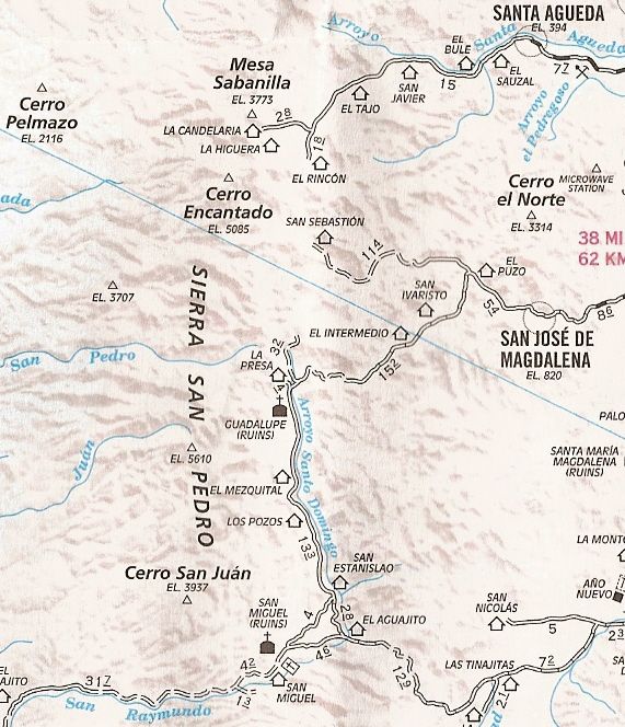
JZ, on this 2010 map, the road that Kurt has reported re-opened is the 15.2 mile-long one between the Guadalupe mission and San José de Magdalena. It
had been totally obliterated after storms of 2014 (I believe the year was) and was still gone when I was up at the mission in 2017.
|
|
|
motoged
Elite Nomad
Posts: 6481
Registered: 7-31-2006
Location: Kamloops, BC
Member Is Offline
Mood: Gettin' Better
|
|
David....I knew you would make my route description comprehend-able...
Clear as a sunny day....
Don't believe everything you think....
|
|
|
David K
Honored Nomad
Posts: 64479
Registered: 8-30-2002
Location: San Diego County
Member Is Offline
Mood: Have Baja Fever
|
|
Ged, always happy to be of service!
|
|
|
JZ
Elite Nomad
Posts: 9226
Registered: 10-3-2003
Member Is Offline
|
|
Thx guys. I'm getting the picture now. Looks like a fun loop. Have the track for the bottom 1/2 leg.
Anyone have some way points for Guadalupe and SJ de Magalena?
[Edited on 11-25-2018 by JZ]
|
|
|
David K
Honored Nomad
Posts: 64479
Registered: 8-30-2002
Location: San Diego County
Member Is Offline
Mood: Have Baja Fever
|
|
See my Trip #6 report from 2017. There is pretty much one road and is not hard to stay on. The only questionable choice was just west of Mulegé but
the two choices going the general direction desired came back together soon. Just north of the sign for the mission site, you take the east fork,
uphill. Just ahead is Rancho La Presa and the end of that road. Just go to Google Earth and note gps points you may want.
|
|
|
| Pages:
1
2
3
4
5 |


