Blair
Junior Nomad

Posts: 63
Registered: 5-19-2010
Location: El Cajon Ca
Member Is Offline
Mood: Getting ready to go again
|
|
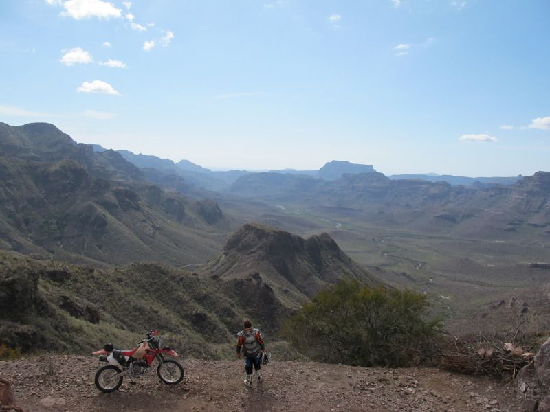
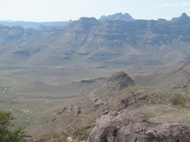
Know this place?
We have ridden through this canyon twice in the last eight years. Its one of the most spectacular (and remote) spots I've been through in central
Baja. We call it the "Grand Canyon" but it has to have a proper name. This pic was taken about 26 55'37N 112 31'35W which is about 35 miles west of
Mulege (as the crow flies). Anyone familiar with it?
[Edited on 9-29-2018 by Blair]
Blair in El Cajon
|
|
|
StuckSucks
Super Nomad
Posts: 2307
Registered: 10-17-2013
Member Is Offline
|
|
Here?
|
|
|
TMW
Select Nomad
Posts: 10659
Registered: 9-1-2003
Location: Bakersfield, CA
Member Is Offline
|
|
Did you do the loop out of Patrocino? Bikes or 4 wheel vehicles? OK I see you were on bikes on facebook. Is the trail OK for 4x4 vehicles?
[Edited on 9-27-2018 by TMW]
|
|
|
woody with a view
PITA Nomad
Posts: 15937
Registered: 11-8-2004
Location: Looking at the Coronado Islands
Member Is Offline
Mood: Everchangin'
|
|
FB foto is unreal!!! Such a magical view. I constantly wonder when I look out the window on our travels up and down the peninsula when I look into the
distance and think to myself, “I wonder if anybody’s ever stood on the top of that hill?”
|
|
|
David K
Honored Nomad
Posts: 64493
Registered: 8-30-2002
Location: San Diego County
Member Is Offline
Mood: Have Baja Fever
|
|
I think Cameron called it a grand canyon as well... On his m/c tours.
|
|
|
Blair
Junior Nomad
Posts: 63
Registered: 5-19-2010
Location: El Cajon Ca
Member Is Offline
Mood: Getting ready to go again
|
|
We made four attempts at this Canyon over the years and were only successful getting through it twice. It was a challenging ride and all was done on
bikes. The climb out of the canyon to the point the pic was taken is steep and rough. The last attempt (unsuccessful) was about four years ago and the
canyon road was a pile of boulders. Glad we had the opportunity when we did. Just wondered if anyone else had been there.
[Edited on 9-28-2018 by Blair]
Blair in El Cajon
|
|
|
TMW
Select Nomad
Posts: 10659
Registered: 9-1-2003
Location: Bakersfield, CA
Member Is Offline
|
|
From where the picture was taken were you riding north or south. Where did you ride from Mulege or Patrocino or San Ignacio. I'm trying to get an
ideal of how you got to where you were.
|
|
|
Blair
Junior Nomad
Posts: 63
Registered: 5-19-2010
Location: El Cajon Ca
Member Is Offline
Mood: Getting ready to go again
|
|
We came in from San Ignacio. On the road from SI to laguna SI, turn south about 27 04 00n; 112 57 15w, continue south to road split @ 26 57 41n 112 52
57w; stay left. Stay in that drainage as it goes east. Becomes steep deep canyon, climb out at east end where that pic is taken. It seems in that area
there are two main drainages running east and west, this is the north one. Spectacular terrain! Haven't been there in five years, access may have
improved or gotten worse. Again, a couple of times we were in there it was impassable. Coming in from El Patrocino may be doable, have not tried it.
Blair in El Cajon
|
|
|
chuckie
Elite Nomad
Posts: 6082
Registered: 2-20-2012
Location: Kansas Prairies
Member Is Offline
Mood: Weary
|
|
Did it on a Montesa Cota trials bike with a BIG tank many years ago....Aint it GRAND!
|
|
|
4x4abc
Ultra Nomad
Posts: 4171
Registered: 4-24-2009
Location: La Paz, BCS
Member Is Online
Mood: happy - always
|
|
Arroyo San Simon to the south
Arroyo San Tadeo to the north
Harald Pietschmann
|
|
|
TMW
Select Nomad
Posts: 10659
Registered: 9-1-2003
Location: Bakersfield, CA
Member Is Offline
|
|
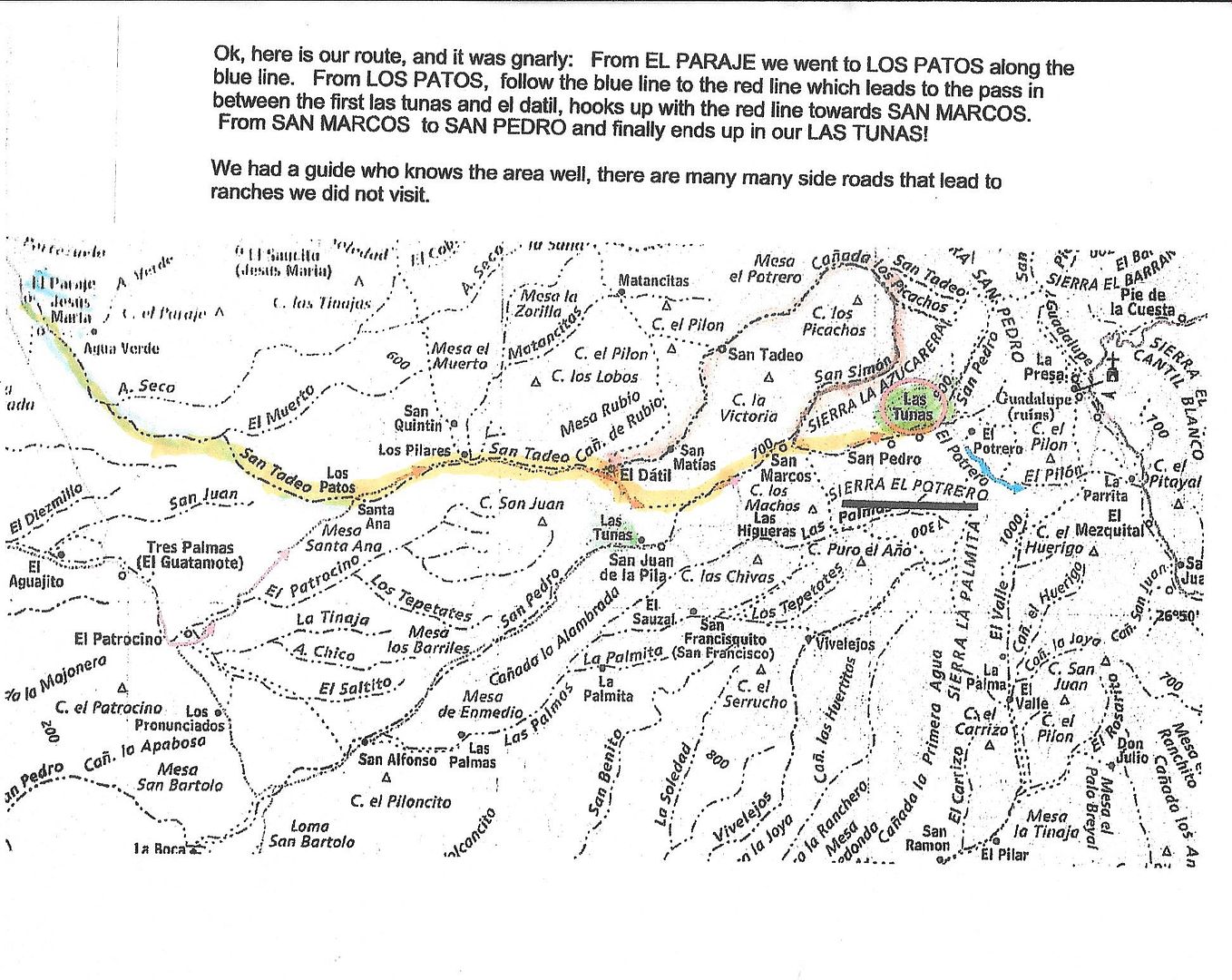
Thanks Blair. BajaBlanca on Nomad knows a family that lives at Rancho Las Tunas, in green on the map below. Blanca and her husband went to the ranch
in an SUV in 2014 and she provided the directions on the map. What she called a blue line I traced over in yellow. I believe your GPS site is above
Las Tunas and slightly to the left where it says San Simon. I think the way you went is by way of San Tadeo.
FYI the rancher at Las Tunas said only horses could get thru from his ranch to the east to the road that goes to the Mission Guadalupe ruins. That
road goes back to Mulege. He did not say how long the bad section was. It would be interesting to go to his ranch and check out the bad section.
Also maybe the next time you do this ride you may want to try the section they were on.
[Edited on 9-28-2018 by TMW]
|
|
|
Blair
Junior Nomad
Posts: 63
Registered: 5-19-2010
Location: El Cajon Ca
Member Is Offline
Mood: Getting ready to go again
|
|
Hey I actually figured out how to post a picture You have to trick it through photobucket. Haven't done that in a few years. Thanks for the map! I can
generally pick out the route but it's difficult to pinpoint with certainty. Now the canyons have names! Thanks folks. My bike group is getting old,
but we might have another shot in us. We'll keep you posted!
Blair in El Cajon
|
|
|
David K
Honored Nomad
Posts: 64493
Registered: 8-30-2002
Location: San Diego County
Member Is Offline
Mood: Have Baja Fever
|
|
Good job on the photo posting!!!   
|
|
|
advrider
Super Nomad
Posts: 1847
Registered: 10-2-2015
Member Is Offline
|
|
This looks very interesting for sure! I have a tract someone gave me that was labeled Mulege mountain track, I'll see if I can post it? It looks like
it runs in this direction?
|
|
|
Blair
Junior Nomad
Posts: 63
Registered: 5-19-2010
Location: El Cajon Ca
Member Is Offline
Mood: Getting ready to go again
|
|
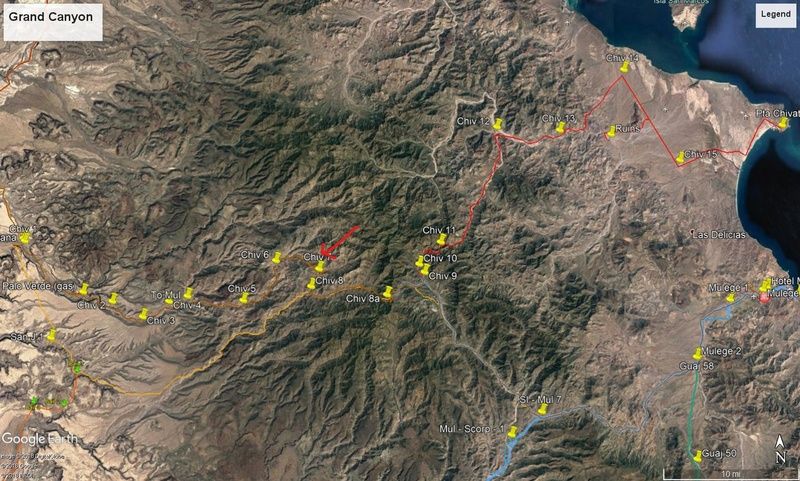
Here's a screen shot of my GE. The canyon in question is the Chiv 4,5,6,& 7 waypoints. The red arrow is about where the pic is taken.
Blair in El Cajon
|
|
|
TMW
Select Nomad
Posts: 10659
Registered: 9-1-2003
Location: Bakersfield, CA
Member Is Offline
|
|
Was the trail you were on mostly a single track for bikes or was it wide enough for a 4x4.
|
|
|
KurtG
Super Nomad
Posts: 1201
Registered: 1-27-2004
Location: California Central Coast
Member Is Offline
Mood: Press On Regardless!!
|
|
I was fortunate to be able to drive this route twice about twenty years ago when there was a short window when it was sort of maintained. The first
time was, I think '97, I was driving in the tracks of the dozer that had just gone through. The route varied at that time, went to Rcho San Pedro and
then to San Juan de la Pila passing the rock painting site before the ranch. The road then continued SW and out to the Laguna San Ignacio road.
This was pre-gps so no route map. In the last 15+ years I know motos have been through there but I'm told 4 wheelers can't make it. I know that the
western end is now a newer route but have not been on it. This is one of the most memorable trips I have done in Baja, the scenery on both sides of
San Juan de la Pila is spectacular but for me the area SW of the ranch was the best.
Both times I was driving my old S-10 Blazer. First time solo and second time with friends in a Toyota Land Cruiser. No problem back then for either
vehicle.
|
|
|
motoged
Elite Nomad
Posts: 6481
Registered: 7-31-2006
Location: Kamloops, BC
Member Is Offline
Mood: Gettin' Better
|
|
Been there....done that....in 2011 with 10 guys....from San Ignacio to Mulege ....killer ride....
DT Bushpilot and I were on overloaded 690's....closest I have ever been to a serious bonking....ran out of water 1/2 way (3 liters)...was sure glad to
make it to La Hacienda and a cold one....
Don't believe everything you think....
|
|
|
TMW
Select Nomad
Posts: 10659
Registered: 9-1-2003
Location: Bakersfield, CA
Member Is Offline
|
|
We went in to San Juan de Las Pilas in April of 2014 and stayed over night at the ranch. As I recall they were Jesus and Guadalupe, she goes by
Lupe.The rancher took us to some rock paintings further to the east. The road is wiped out past the ranch to the east except for the most hardcore
bike riders. There have been a few riders go past the ranch but it is a hard section for about 2-3 miles. On the map above it is easier to take the
route Blanca talks about. To go on to Mulege you have to get thru the bad section from Rancho Las Tunas east as the rancher says only horses and maybe
motorcycles can do it.
I did a trip report at http://forums.bajanomad.com/viewthread.php?tid=73500
|
|
|


