| Pages:
1
2
3 |
David K
Honored Nomad

Posts: 64476
Registered: 8-30-2002
Location: San Diego County
Member Is Offline
Mood: Have Baja Fever
|
|
Just stay tuned and see how things are the day before your trip. In 2010, it was Highway 1 that had several bridges washed out.
|
|
|
samhigh
Newbie
Posts: 5
Registered: 10-9-2018
Member Is Offline
|
|
Friday 10/12 - San Diego to Punta Bufeo
Nomad Crew,
Thanks for the updates in this thread. I am debating about my upcoming trip.
Leaving San Diego Friday, 10/12 in the early AM, trying to head all the way to Punta Bufeo before sun down. Return Sunday or Monday. Will be in a
2x4 toyota tundra.
Is it crazy to even try? The pictures of the 5 FWY collapsed / washed out has me feeling a little worried.
Some Alternatives:
Stay in San Felipe instead.
Stick to the Pacific coast, wait for the 5 FWY to be repaired
Any feedback greatly appreciated. Thanks!
|
|
|
vandenberg
Elite Nomad
Posts: 5118
Registered: 6-21-2005
Location: Nopolo
Member Is Offline
Mood: mellow
|
|
With that time frame, you better keep an close eye on Sergio.Looks like bad timing to me.
|
|
|
BajaDanD
Senior Nomad
Posts: 745
Registered: 8-30-2003
Member Is Offline
|
|
We drove through from San Felipe to Chapala on Saturday Oct 6th Starting from about 25k south of San Felipe the road is wasted every bridge every
culvert is washed out and sections of road are just missing. Rock slides go for miles blocking the southbound lane. Everything from about 10k before
Gonzaga to Chapala is the same as it has always been and didn't look like the storm did any damage.
It was definitely an adventure you can only find in Baja we had to make our own path at times there was so much road damage that some of the normal
Baja bypasses had not been constructed yet at some of the washouts. It is passable but we needed 4x4 a few times.
All I can say is that it was sad but fun. Id say it won't be repaired for a few years
|
|
|
Cappy
Nomad
Posts: 146
Registered: 6-4-2012
Location: Rancho Aguja
Member Is Offline
|
|
Road report from friends driving north La Paz to San Felipe.
“ Road is pretty messed up. Multiple crews cleaning up and forming bypass. 4 3\4 hours from turnoff at hwy 1 to San Felipe. 20 minute stop at Coccos
( all good) fuel available at Gonzaga . They where driving all wheel drive suburban pretty much stock. This report was as of Tuesday
|
|
|
David K
Honored Nomad
Posts: 64476
Registered: 8-30-2002
Location: San Diego County
Member Is Offline
Mood: Have Baja Fever
|
|
Thanks!
|
|
|
BajaDanD
Senior Nomad
Posts: 745
Registered: 8-30-2003
Member Is Offline
|
|
We drove from San Felipe to Chapala on the 6th it was bad but not impossible starting from about 25 km South of San Felipe every bridge and culvert
was washed out huge sections of road was missing we had to use 4 x 4 a lot. Some sections still have no bypass around. We followed tire tracks
sometimes a 1/4 mile off to the side that eventually brought us back to the road longest detour was maybe 1/2 mile long
The section that runs through the lava fields had Boulders and rocks blocking the southbound lane for miles but passable
The road crews were at the southern most bridge washout working there way North. Some of the Boulders looked too big for the equipment they were using
hopefully they get some bigger equipment in there
We are heading north from Cabo Pulmo tomorrow morning we will probably go back the same way. Baja, It's all about the adventure right
I'll give an update when I get home
|
|
|
BajaDanD
Senior Nomad
Posts: 745
Registered: 8-30-2003
Member Is Offline
|
|
Forgot to mention the look on the faces of the guys at the military checkpoint just north of Gonzaga when we drove up.
Priceless
|
|
|
samhigh
Newbie
Posts: 5
Registered: 10-9-2018
Member Is Offline
|
|
Saw this on the Peurtocitos Happenings FB page today:
I crossed from Puertecitos to San Felipe again today. The road is much better. I think trucks could pull average trailers like 24'. I think cars can
make it just watch out for a few rocks sticking up could put a hole in your oil pan. Took me 90 min at night in a truck. I dont think big motor homes
can make it yet. there are a few washes still to steep/
Thanks Bryan for the update.
|
|
|
redhilltown
Super Nomad
Posts: 1130
Registered: 1-24-2009
Location: Long Beach, CA
Member Is Offline
|
|
Drove it Sunday north from Chapala to San Felipe. If careful it is quite doable. The bypass roads while not marked are certainly obvious. Only real
stretch that is tough where you can lose the bypass roads is the mess near Huerfanito. If you see anyone ask them the best route. As someone said it
is going to take years to get this sucker right again.
|
|
|
SuperScrappy
Newbie
Posts: 10
Registered: 2-7-2016
Member Is Offline
|
|
Rosa Update to Mex 5 (10/10). Much better then when we came thru on 10/7. More heavy equipment and go arounds near all of the bridges that were out.
No the road is not closed (reports were that it was. There was a sign on the Chapala end that had fallen down, but think it was more to detour the
semi-trucks). I still would not recommend semi-trucks or RV's. But the road is very doable in trucks and cars with good clearance. I would NOT
travel at night as there are several areas of payment that are cracked/fallen that are not marked well. There are surveyors out (I am sure trying to
figure out where to place new bridges). There is no work going on the dirt road south of Gonzaga to Chapala. But it is in really good condition and
completed that section in about 40 minutes. I posted a bunch of pictures on Talk Baja on FB
|
|
|
BajaDanD
Senior Nomad
Posts: 745
Registered: 8-30-2003
Member Is Offline
|
|
We left Guerrero Negro Friday morning around 7:30 arrived home in Prescott Arizona at 9:00pm. When we got to Chapala we sat there trying to decide
between Hwy 1 or Hwy 5 it was raining and looked like the storm was right over the Hwy 5 route. Looking north on Hwy 1 while we sat there a rainbow
appeared. I saw that as a sign to go the other way, east into the storm. It rained all the way to just before San Felipe.
We had come through there going south 5 days earlier we felt that it would be a better choice.
There were bypass routes around all the washouts and crews working to clear rocks
Baja ingenuity at it's finest
|
|
|
mtnpop
Senior Nomad
Posts: 597
Registered: 9-8-2009
Location: Colorado/mulege
Member Is Offline
|
|
Well, arrived in San Felipe this afternoon headed south. Have not seen or heard much news about 5 over to mex 1 for a few days so thought we might
take the chance. Have had some conflicting reports but trying to get more info from locals.
Think we can probablly negotiate it with the raised H3 with really new tires etc. will take it slow and send post a report tomorrow evening if we get
through. do not want to go back north and cross over to 1 at ensenada (sp)
Was shocked to see magna at 19.75 a litre and the good stuff at 21.20 but what will be. also two of the pemix stations in San Felipe arre now an
Arco and a Chevron. did not see their posted price.
Will try to get pics on 5 but don't know if I can get them posted.
wish we had a couple of travelin buddies to tag along with but not yet..
happy trails....
Common sense is a flower that doesn\'t grow in everyone\'s garden.....
A wise man once spoke nothing.....
Never kick a cow chip on a hot day!!
|
|
|
Pacifico
Super Nomad
Posts: 1299
Registered: 5-26-2008
Member Is Offline
|
|
Quote: Originally posted by mtnpop  | Well, arrived in San Felipe this afternoon headed south. Have not seen or heard much news about 5 over to mex 1 for a few days so thought we might
take the chance. Have had some conflicting reports but trying to get more info from locals.
Think we can probablly negotiate it with the raised H3 with really new tires etc. will take it slow and send post a report tomorrow evening if we get
through. do not want to go back north and cross over to 1 at ensenada (sp)
Was shocked to see magna at 19.75 a litre and the good stuff at 21.20 but what will be. also two of the pemix stations in San Felipe arre now an
Arco and a Chevron. did not see their posted price.
Will try to get pics on 5 but don't know if I can get them posted.
wish we had a couple of travelin buddies to tag along with but not yet..
happy trails.... |
You will be just fine in your H3... Good luck!
"Plan your life as if you are going to live forever. Live your life as if you are going to die tomorrow." - Carlos Fiesta
|
|
|
mtnpop
Senior Nomad
Posts: 597
Registered: 9-8-2009
Location: Colorado/mulege
Member Is Offline
|
|
Wow, those 2 storms made a mess of 5 north and south of Puertocitas.
bridges, culverts, roadway. it is passable and many 18 wheelers were using it, not sure how but there they were. would not recommend pulling any
trailer or driving a big motorhome through this way for awhile.
We were on it on Sunday so no workers anywhere... lots of equipment still there but no live bodies..
mex 1 is pretty much pot hole gone now so it was a good drive south..
later
Common sense is a flower that doesn\'t grow in everyone\'s garden.....
A wise man once spoke nothing.....
Never kick a cow chip on a hot day!!
|
|
|
BajaMama
Super Nomad
Posts: 1106
Registered: 10-4-2015
Location: Pleasanton/Punta Chivato
Member Is Offline
Mood: Got Baja fever!!
|
|
I did indeed drive the five from Mex 1 to San Felipe. For those of you who have never driven this route before: DON'T follow the sign that indicates
a right turn to Mexicali/San Felipe. You will end up at Coco's Corner. Then you back track 4 miles to another road in which you will question your
sanity for doing alone (I did not pass ONE other vehicle) and wondering "why does everyone say trucks can take this road" because you know there in no
way in h - e - double hockey sticks a semi can negotiate those steep big rocks.
So fellow nomads, where did I make the wrong turn? Was it at the sign or before that? BTW I was heading north.
|
|
|
BajaMama
Super Nomad
Posts: 1106
Registered: 10-4-2015
Location: Pleasanton/Punta Chivato
Member Is Offline
Mood: Got Baja fever!!
|
|
Okay, now I'm looking at Google Maps, and it indicates that Mex 5 goes right past Coco's. Is that right, and did I listen to a local gentleman who
purposely steered me in the wrong direction? (at Coco's I asked if I was on the correct road and he said no and told me to go the way I did...)
[Edited on 10-31-2018 by BajaMama]
|
|
|
David K
Honored Nomad
Posts: 64476
Registered: 8-30-2002
Location: San Diego County
Member Is Offline
Mood: Have Baja Fever
|
|
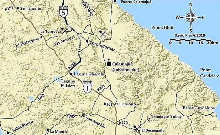
Coco's Corner has been on the main road between Chapala and Gonzaga since the 1990s.
The new highway route bypasses Coco's to the west (see my dashed lines for that part. The north end is at Las Arrastras) but it is not completed and
there is a rough almost 1-mile detour to get to it and avoid Coco's or to see the newer road.
In the meantime, all traffic should just continue to go by Coco's.
I gave great detail of this with satellite maps in my August 2018 trip report (TRIP #8).
|
|
|
BajaMama
Super Nomad
Posts: 1106
Registered: 10-4-2015
Location: Pleasanton/Punta Chivato
Member Is Offline
Mood: Got Baja fever!!
|
|
Thanks David, looks like I should not have listened to the gentleman who guided me back four miles and just kept going forward past Cocos.
Unfortunately I thought I read on a recent BN post that if you ended up at Cocos you made a wrong turn somewhere... Oh well, live and learn! It was
an adventure. Next time I will make sure I am in my husband's 2006 Ford F250 diesel 4x4!
|
|
|
David K
Honored Nomad
Posts: 64476
Registered: 8-30-2002
Location: San Diego County
Member Is Offline
Mood: Have Baja Fever
|
|
You have researched this trip so heavily, too. Oh well, now you know. Please feel welcome to print any of my maps to take with you.
|
|
|
| Pages:
1
2
3 |