| Pages:
1
2 |
wyatthurley55
Junior Nomad

Posts: 58
Registered: 9-18-2017
Location: Alpine Ca
Member Is Offline
Mood: Craving Pacifico
|
|
HWY 5 South Updates
Has anyone travelled from San Felipe to Gonzaga recently? I've read and heard that the road is passible and seen the pictures but has anyone put a
time frame on it? Any info would be appreciated. Thanks
 
|
|
|
bkbend
Senior Nomad
Posts: 693
Registered: 11-27-2003
Location: central OR or central baja
Member Is Offline
|
|
I drove it Sunday 10/14, no problems. I was in a pickup but cars and semis were on the road.
http://forums.bajanomad.com/viewthread.php?tid=91235
|
|
|
wyatthurley55
Junior Nomad
Posts: 58
Registered: 9-18-2017
Location: Alpine Ca
Member Is Offline
Mood: Craving Pacifico
|
|
Thats all I needed. Thanks!!!
|
|
|
MexicoTed
Senior Nomad
Posts: 708
Registered: 8-2-2004
Member Is Offline
|
|
Did you take these photos? If so when and where?
|
|
|
basautter
Senior Nomad
Posts: 862
Registered: 7-1-2013
Member Is Offline
|
|
Yikes! I am planning a trip in November. Hope those road workers are quick to fix this (yea, right)...
|
|
|
bkbend
Senior Nomad
Posts: 693
Registered: 11-27-2003
Location: central OR or central baja
Member Is Offline
|
|
I suspect it's as fixed as it's going to be for several years. Back in something like 2010 the northern part of Mex 1 had several bridges wash out
from winter storms and it took a couple years to replace them. I don't think Mex 5 has that kind of priority. It's a mess for about 30 miles. I
stopped to visit Coco and his theory is they didn't use any real engineers to design it, the politician in charge hired a brother-in-law who didn't
know crap to draw up some plans. After seeing the mess, that's as good a guess as any.
But, you can get through, it's easy, the detours are marked, the hazards are marked, I was coming out of Nevada so it's still a lot quicker. I lost
more time waiting for an arroyo to drain out on hwy 78 between Blythe and Glamis than I did on Mex 5. I left San Felipe at 7:30, spent 30 minutes
with Coco, and had tacos in Bahia de los Angeles at 1pm. And I don't drive fast.
|
|
|
David K
Honored Nomad
Posts: 64480
Registered: 8-30-2002
Location: San Diego County
Member Is Offline
Mood: Have Baja Fever
|
|
Quote: Originally posted by bkbend  | I suspect it's as fixed as it's going to be for several years. Back in something like 2010 the northern part of Mex 1 had several bridges wash out
from winter storms and it took a couple years to replace them. I don't think Mex 5 has that kind of priority. It's a mess for about 30 miles. I
stopped to visit Coco and his theory is they didn't use any real engineers to design it, the politician in charge hired a brother-in-law who didn't
know crap to draw up some plans. After seeing the mess, that's as good a guess as any.
But, you can get through, it's easy, the detours are marked, the hazards are marked, I was coming out of Nevada so it's still a lot quicker. I lost
more time waiting for an arroyo to drain out on hwy 78 between Blythe and Glamis than I did on Mex 5. I left San Felipe at 7:30, spent 30 minutes
with Coco, and had tacos in Bahia de los Angeles at 1pm. And I don't drive fast. |
Excellent observation. The brother-in-law answer may be as good as any. This is a new highway (south of Puertecitos), started in 2007, and the
Huerfanito-Encantadas area, where the bridges washed out, was built about 2010-2012. The purpose of bridges is so the flood water can pass below the
highway, not take it out. The highway 1 bridges that washed out in 2010 dated back to 1973 or earlier.
|
|
|
wyatthurley55
Junior Nomad
Posts: 58
Registered: 9-18-2017
Location: Alpine Ca
Member Is Offline
Mood: Craving Pacifico
|
|
I didnt take the pictures, I have a buddy that lives in San Felipe and he aquired the photos somehow and said the road was pretty bad. Im headed to
Gonzaga Bay for the 1000 and just wanted an update. Thanks everyone
|
|
|
David K
Honored Nomad
Posts: 64480
Registered: 8-30-2002
Location: San Diego County
Member Is Offline
Mood: Have Baja Fever
|
|
The photos are similar to those posted on some Facebook pages (Puertecitos Happenings, South Campos Amigos, etc.) following the ~Oct. 1 flash floods.
The word today seems to be all but can pass using the detours with only motorhomes not recommended. The semi trucks are back using Hwy. 5, but they
are not having an easy time. It is still preferred over the extra 'nearly 200' miles going on Hwy. 1 from Mexicali.
|
|
|
BajaMama
Super Nomad
Posts: 1106
Registered: 10-4-2015
Location: Pleasanton/Punta Chivato
Member Is Offline
Mood: Got Baja fever!!
|
|
So everyone , would you recommend the 5 for someone who has never driven it?
|
|
|
TMW
Select Nomad
Posts: 10659
Registered: 9-1-2003
Location: Bakersfield, CA
Member Is Offline
|
|
Of course. There will be drive arounds at all the bad spots. Think of it as an adventure.
|
|
|
bkbend
Senior Nomad
Posts: 693
Registered: 11-27-2003
Location: central OR or central baja
Member Is Offline
|
|
The storm damage is no issue. It could be confusing in the area of construction south of Gonzaga Bay if you haven't been through it and don't know
the lay of the land. The original road, which is the "official" route for most of it, criss-crosses the new construction multiple times and most
barriers directing traffic seem to have been moved off the side. I drove quite a bit of the new roadbed although I did bail out to visit Coco and
picked it back up for the final run to Chapala. Apparently you cannot drive the new roadbed for the entire length. Coco told me he has had a couple
visitors heading south who exited the new road south of him yet still showed up at his place wondering how far it was to Chapala. It sounded like
there was a confusing junction in there some place. The key would be to remember both roads head south, then southwest, then west and if you keep
heading that way you'll get to where you're going. There's also enough traffic on the road you could follow someone and hope they know where they're
going. And it's always an adventure.
|
|
|
David K
Honored Nomad
Posts: 64480
Registered: 8-30-2002
Location: San Diego County
Member Is Offline
Mood: Have Baja Fever
|
|
| Quote: Originally posted by bkbend | | The storm damage is no issue. It could be confusing in the area of construction south of Gonzaga Bay if you haven't been through it and don't know
the lay of the land. The original road, which is the "official" route for most of it, criss-crosses the new construction multiple times and most
barriers directing traffic seem to have been moved off the side. I drove quite a bit of the new roadbed although I did bail out to visit Coco and
picked it back up for the final run to Chapala. Apparently you cannot drive the new roadbed for the entire length. Coco told me he has had a couple
visitors heading south who exited the new road south of him yet still showed up at his place wondering how far it was to Chapala. It sounded like
there was a confusing junction in there some place. The key would be to remember both roads head south, then southwest, then west and if you keep
heading that way you'll get to where you're going. There's also enough traffic on the road you could follow someone and hope they know where they're
going. And it's always an adventure. |
I drove as much of the new roadbed as seemed possible. The approx. 1 mile of new road alignment was where it cuts into the canyon to the construction
camp. The detour is rough, just under a mile long, and drops you down to the old route just east of the canyon. If you turned left there, it would
take you to Coco... that would be pretty obvious the wrong way to turn to continue south.
Here is my GPS track on the new roadbed, except for that last piece on the south end, which is the detour down the hill to the older road:
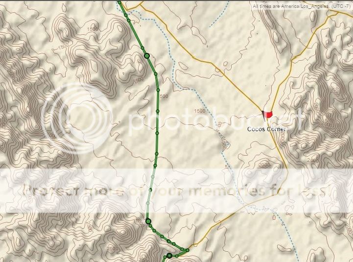
Here is the section not yet open, the final mile, up there on the left side of the canyon:
[Edited on 10-22-2018 by David K]
|
|
|
mtnpop
Senior Nomad
Posts: 597
Registered: 9-8-2009
Location: Colorado/mulege
Member Is Offline
|
|
Did it yesterday, Sunday the 21st. probably more than a dozen 18 wheelers going both directions. Some areas have to be a challenge for them.
The new construction north of Puertecitos really took a big hit. much of the new road to Gonzaga was where the flooding happened. the construction
area didn't have any problems we saw. We did get a military contigent under one of the new bridges before Coco's stopped us and wanted to inspect
everything in the truck. not a regular checkpoint. everything is marked pretty well. someone has moved some of the detour barrels so watch for
that... on the new construction they have put white arrows on orange background pointing the directions you are supposed to go, helped some.
had we no had a flat at Puretecitos we would have made great time.
Would not recommend motorhomes or really low slung cars although there were some doing it.
Lots of recycle haulers are using this route so watch for metal junk dropped on the road, that's what got us...
No workers but it was Sunday so didn't expect any really.
Left San Felipe at about 8 am and hit Chapala at about 1 pm this even with the 2 hour delay with the tire problem. but we are in a H3...
And you will not believe the mountains and valley's We have never seen the green you will see right now... like a green carpet for miles..
Drive safe and happy trails...
Don't forget water and snacks.....just in case.
Common sense is a flower that doesn\'t grow in everyone\'s garden.....
A wise man once spoke nothing.....
Never kick a cow chip on a hot day!!
|
|
|
bkbend
Senior Nomad
Posts: 693
Registered: 11-27-2003
Location: central OR or central baja
Member Is Offline
|
|
DavidK - your map shows the chunk I skipped, I left right at the top of the map for Coco's and I think I remember the road coming down the hill at the
mouth of the canyon.
|
|
|
mtnpop
Senior Nomad
Posts: 597
Registered: 9-8-2009
Location: Colorado/mulege
Member Is Offline
|
|
The big mountain they are taking down close to the large camp is still a pretty large mountain. If you look one culvert is way down in the valley and
not anywhere close to being covered. You get on road base just after the camp and we were on the pavement thru the lakebed, couple hundered yards
at the west end not paved yet. Also mostly one lane as there are piles of asphalt in one lane and no curb on the other side.
Old road to Coco's was graded pretty well and made good time. met a couple of 18 wheelers there. No big worries just gotta pay attention.
Common sense is a flower that doesn\'t grow in everyone\'s garden.....
A wise man once spoke nothing.....
Never kick a cow chip on a hot day!!
|
|
|
bajaric
Senior Nomad
Posts: 602
Registered: 2-2-2015
Member Is Offline
|
|
I drove from San Felipe to Cinco Islas (about 22 miles south of Puertecitos) and then back north Oct 19-22. Fairly easy drive in a pickup. From
north to south, the vados were all washed out but they had been filled in with dirt. The new road construction around Cow Patty was destroyed but the
side road was fixed up and passable. The new highway south of Puertecitos was hit hard. Two big bridges near Huerfanito were damaged and detours
built around/under them with short steep dirt sections, traffic is chewing up the road on the grades. Saw a scrap metal truck that had turned around
and was going back south because it could not negotiate the grade. I also ran over some kind of scrap metal, I think, never saw it but heard a
scratching sound, stopped and reversed and it went away, when I got to my destination there was a big scratch of red paint on the door.
The panga fleet has occupied many of the beaches in the area now that gill netting has been banned north of Huerfanito. You can buy fish fresh off
the boats, but camping in their midst has a certain lack of ambiance. Think bright fluorescent lights, trucks launching boats 24/7, and loud mariachi
music at 5am. Took a moto ride / hike up a big arroyo to the east and was amazed at the volume of water that had rushed down it. Obliterated
everything. Was rewarded with the sight flowing water in the upper reaches of the arroyo with lots of algae and pollywogs and a couple of small
waterfalls. No other tracks besides mine; I was the only person that saw it. The desert is springing to life, green everywhere. I would estimate a
couple billion house flies and gnats were born the day before I got there. Headed up to Octavios camp next day and the flies were even worse there.
Not so bad out walking around in the sun but as soon as you sat down under the palapa there were hundreds of them everywhere and on everything.
|
|
|
David K
Honored Nomad
Posts: 64480
Registered: 8-30-2002
Location: San Diego County
Member Is Offline
Mood: Have Baja Fever
|
|
Thanks, bajaric! Bummer on the insects and lack of beach peace.
Do try Shell Island for peaceful, clean camping if you can get to it and drive in deep sand. There is a seasonal fish camp near where the road reaches
the beach, but you can go south 1 mile or north 3 miles from the road to find other island camp spots.
|
|
|
bajaric
Senior Nomad
Posts: 602
Registered: 2-2-2015
Member Is Offline
|
|
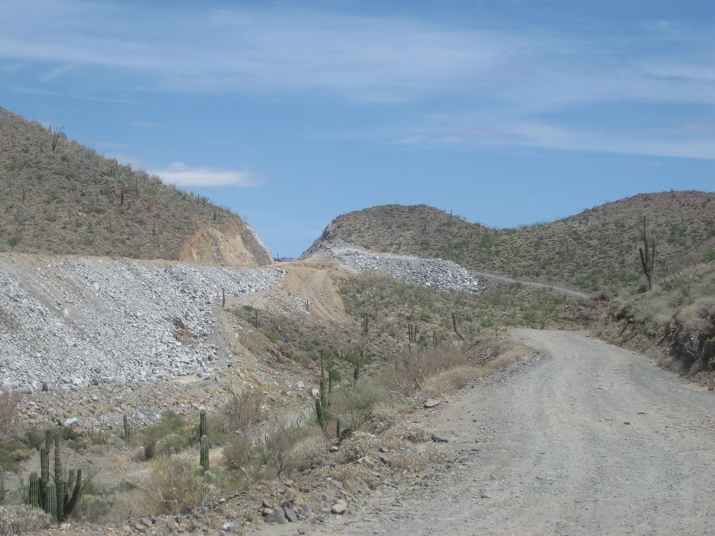
You betcha DK, I get some good info from this forum so like to contribute my 2 cents now and then. A few pics:
   
|
|
|
freediverbrian
Senior Nomad
Posts: 615
Registered: 2-24-2007
Location: Papas Gonzaga Bay
Member Is Offline
|
|
Like to support the local fisherman but camping next to a fish camp is a a bad idea . The noise the trash is all bad
|
|
|
| Pages:
1
2 |


