| Pages:
1
2 |
aburruss
Nomad

Posts: 216
Registered: 2-6-2018
Member Is Offline
|
|
Arroyo Grande
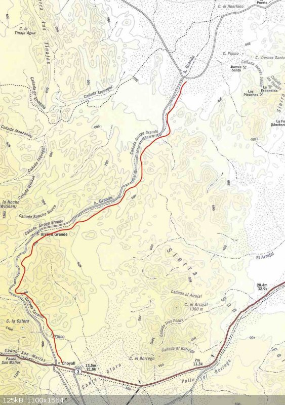
Hi all, I'm looking for some advice. The wife and kids and I (and hopefully a couple of others) are doing some exploring the week of Thanksgiving,
and we are trying to plan our route a little bit. But I'm running up on some information that I think I need some advise on from some of you who are
more familiar with things..
We're leaving Guadalupe Canyon, and are trying to get to Mike's that night. We will be in a Razor and a very capable jeep. From looking at a 2003
Baja Almanac, it looks like this route through Arroyo Grande will connect us up to Highway 3 (see red line along route) .. However from looking at
DavidK's 2018 map of the area, it appears that this peters off into nothing. Google Earth seems to more agree with DavidK's maps, but I can't exactly
tell, and I've never gone through this area.
Does anyone have any thoughts for me on this? Best route to take from Guadalupe Canyon to Mikes? The least road miles possible is preferred.
Thanks guys!!

[Edited on 6-30-2022 by BajaNomad]
|
|
|
4x4abc
Ultra Nomad
Posts: 4163
Registered: 4-24-2009
Location: La Paz, BCS
Member Is Offline
Mood: happy - always
|
|
Arroyo Grande is a great trip. It can get challenging once you get towards the rancho. The outlet south to MEX3 is blocked by several gates.
But there is a new road that takes you west and straight into Lazaro Card##as.
Go west at 31°22'44.92"N, 115°29'48.57"W
Harald Pietschmann
|
|
|
ehall
Super Nomad
Posts: 1906
Registered: 3-29-2014
Location: Buckeye, Az
Member Is Offline
Mood: It's 5 o'clock somewhere
|
|
Anyone been on the summit or mini summit recently? Another option.
|
|
|
ehall
Super Nomad
Posts: 1906
Registered: 3-29-2014
Location: Buckeye, Az
Member Is Offline
Mood: It's 5 o'clock somewhere
|
|
El Mano also
|
|
|
David K
Honored Nomad
Posts: 64480
Registered: 8-30-2002
Location: San Diego County
Member Is Offline
Mood: Have Baja Fever
|
|
Quote: Originally posted by 4x4abc  | Arroyo Grande is a great trip. It can get challenging once you get towards the rancho. The outlet south to MEX3 is blocked by several gates.
But there is a new road that takes you west and straight into Lazaro Card##as.
Go west at 31°22'44.92"N, 115°29'48.57"W |
Harald, that waypoint seems to be past the gate you guys had to get through? aburruss sounds like he wanted to come from the east (where we searched
for the Melchior Diaz grave?
aburruss, it was 4x4abc who said the exit to San Matias Pass (via Rancho Arroyo Grande) was blocked by a locked gate, back in 2015 so I didn't show it
going through on my map, beyond where I have been to a couple times. However, to get to Arroyo Grande from Guadalupe Canyon would require using the
1942 WWII Pole Line Road, and that is an all day or even 2-day event given the conditions of it! Go south from Guadalupe Canyon to Coahbuzo Jcn. then
turn east on the SCORE race road to Hwy. 5. Then take 5 to 3 and go west to Mike's road. The SCORE road was so bad when I used it many years ago, it
would have been faster to go around via Mexicali Hwy. 2-D!
[Edited on 6-30-2022 by BajaNomad]
|
|
|
4x4abc
Ultra Nomad
Posts: 4163
Registered: 4-24-2009
Location: La Paz, BCS
Member Is Offline
Mood: happy - always
|
|
locked gates here:
31°21'59.86"N, 115°27'49.56"W
and here:
31°18'7.79"N, 115°25'39.70"W
Harald Pietschmann
|
|
|
PaulW
Ultra Nomad
Posts: 3005
Registered: 5-21-2013
Member Is Offline
|
|
It is all about opinions. AG has only been traversed in the last 10 years by one 4x4 party. Bikes do keep silently get thru. Ihave di=riven all teh
routes below numerous times , but never breached teh locked gates in AG.
IMO, here are your options:
* From the north. Guad to AG via Saldana then enter AG from the north. Lots of fuel required due to distance and deep sand. Low on fuel go to Hwy 5
then N to the first PMEX then return via La Ventana and then AG.
Fuel still becomes an issue if you choose to not damage the gate locks and have to return back north. Gate advice from 4x4abc is very reliable.
Of course once at Hwy 5 then its highway all the way to the hwy 3 exit to Mikes.
* From the south AG access find a locked gate at Hwy3. I think there is an unexplored go around thru the bushes but the locked gates further north
are still an issue and still exist.
* From Guad via El Mono pass and then back to Hwy 3 then to Mikes. Will require permission and a token payment from the ranch owner. All recent
reports say it will be a friendly deal.
* I know all about the pole line road and do not recommend using it due to the unfriendly ranch owner and the need to bypass various gates etc. Plan
on a very long day to get from Guad to AG , and then you still need a fuel stop.
* The race summit is passable from the north (or south) by using the ledge route. A recommended way to go an is the way I would go from Guad to Mikes.
* The so called mini summit (telegraph or power line pass) is way beyond what you would want to do. That route will require more than one Jeep with
winches to be passable. That route a has only been done twice in the last 15 years by 4x4s. Bikes much more frequent. Hard core route!
* David's maps are accurate.
========== ==
| Quote: Originally posted by aburruss | Hi all, I'm looking for some advice. The wife and kids and I (and hopefully a couple of others) are doing some exploring the week of Thanksgiving,
and we are trying to plan our route a little bit. But I'm running up on some information that I think I need some advise on from some of you who are
more familiar with things..
We're leaving Guadalupe Canyon, and are trying to get to Mike's that night. We will be in a Razor and a very capable jeep. From looking at a 2003
Baja Almanac, it looks like this route through Arroyo Grande will connect us up to Highway 3 (see red line along route) .. However from looking at
DavidK's 2018 map of the area, it appears that this peters off into nothing. Google Earth seems to more agree with DavidK's maps, but I can't exactly
tell, and I've never gone through this area.
Does anyone have any thoughts for me on this? Best route to take from Guadalupe Canyon to Mikes? The least road miles possible is preferred.
Thanks guys!!
|
|
|
|
TMW
Select Nomad
Posts: 10659
Registered: 9-1-2003
Location: Bakersfield, CA
Member Is Offline
|
|
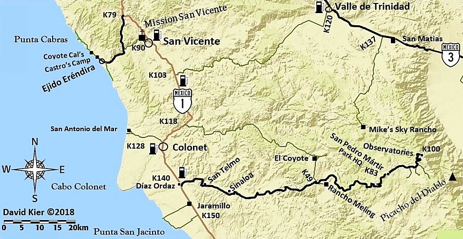
I would suggest you take the SCORE race course from Arroyo Grande south of the wells to the Borrego crossing at Hwy 3 KM179. Then Hwy 3 west to Mikes
turnoff. Not many have done the Arroyo Grande to Hwy 3 or further west. Harald is one of the few who has.
|
|
|
PaulW
Ultra Nomad
Posts: 3005
Registered: 5-21-2013
Member Is Offline
|
|
Or Score track from AG to Chinero via one of the passes to Km 134 on Hwy 5. Much easier that going to Borrego, but a little longer drive.
In any event either the Borrego or Chinero track is less distance to get to Mikes than going via La Ventana.
[Edited on 10-29-2018 by PaulW]
|
|
|
4x4abc
Ultra Nomad
Posts: 4163
Registered: 4-24-2009
Location: La Paz, BCS
Member Is Offline
Mood: happy - always
|
|
Pole Line Road plus Arroyo Grande here: https://carlosnpainter.smugmug.com/Events/Glass-insulators-a...
Harald Pietschmann
|
|
|
4x4abc
Ultra Nomad
Posts: 4163
Registered: 4-24-2009
Location: La Paz, BCS
Member Is Offline
Mood: happy - always
|
|
there was another gate that was not locked at the time:
don't have the exact GPS, but around here somewhere:
31°25'8.98"N, 115°28'28.75"W
[Edited on 10-29-2018 by 4x4abc]
Harald Pietschmann
|
|
|
David K
Honored Nomad
Posts: 64480
Registered: 8-30-2002
Location: San Diego County
Member Is Offline
Mood: Have Baja Fever
|
|
aburruss, there is no 'short-cut' (time-wise) south from Guadalupe Canyon. Driving back to Hwy. 2 and going around will be the quickest.
The roads south from Guadalupe are all cross-grain and unless recently graded, will be slow with many whoops. Only off-road racers or light buggies
can do the roads south quickly! If you have a couple days before needing to be at Mike's Sky Rancho, then go south and have fun... great country! Here
are 4 routes, mentioned by my friends, above...
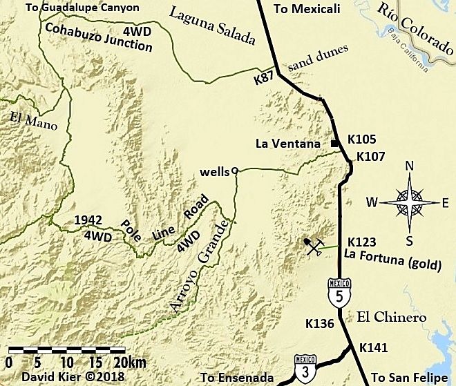
South from Guadalupe Canyon is Cohabuzo Jcn. There is nothing there but a flat area where the road east meets the north/south road.
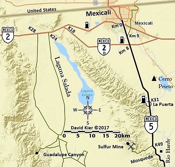
1) Cohabuzo Jcn. east to Hwy. 5 at the sand dunes (Km. 87) would be the next fastest way.
2) Cohabuzo Jcn. south the bottom of the summit and then to the top of the mountain and out to Hwy. 3, south of Independencia. There are maybe three
'summit' roads up, the southernmost one has a gate beyond the top. Not sure what the 'min-summit' is?
3) Cohabuzo Jcn. south to the Pole Line Road requires getting around a steel gate... we did in 2015 (details in trip report with GPS track map) but
things change! The Pole Line Road to Arroyo Grande is a full day, low range use, drive. From there turn north to the wells then east to La
Ventana...Km. 105+ on Hwy. 5.
4) Arroyo Grande at the Pole Line Road crossing is where the SCORE road goes south-east (still the Pole Line Road partially) to either El Chinero
(north of Km. 136) or to Borrego Wash pit area on Hwy. 3 (Km. 179.5). This road is very rough and slow if you are in a Jeep or other 4x4 with camping
gear, loaded down.
The road shown on maps from Ejido Saldaña south to the Pole Line Road, near Arroyo Grande was totally gone in 2015... ask Ken Cooke and those who
followed him!
Now, if the gates are not locked at Rancho Arroyo Grande, you have those other routes Harald mentioned with GPS points. But, getting to Arroyo Grande
still means using the Pole Line Road and that is an extreme 4x4 route since the last big rains.
[Edited on 6-30-2022 by BajaNomad]
|
|
|
4x4abc
Ultra Nomad
Posts: 4163
Registered: 4-24-2009
Location: La Paz, BCS
Member Is Offline
Mood: happy - always
|
|
here is the new bypass for the gates:
http://baja101.com/Baja-GPS/4x4-rural.kmz
Harald Pietschmann
|
|
|
PaulW
Ultra Nomad
Posts: 3005
Registered: 5-21-2013
Member Is Offline
|
|
Findin your way across the race summit
Hwy3 via Race summit from Cahabuzo Junction
Expect good traveled road in spite of the weather for nearly all the route description.
Looking at the GE image and starting at Cahabuzo arrive at a gate just after Mono Junction. Go thru the gate and follow Arroyo Saiz. Or do not open
the fence gate and follow the road to the right. The road to the right joins Saiz later at a very sharp turn. Of course, the arroyo will be deep sand
and the road to the right will be hard pack with big rocks.
Traveling in Saiz you come to a fence gate – do not enter thru the fence gate instead keep right using the race track up the hill. This place is
where the Pole Line Road begins by going thru the fence gate – not recommended. I call that up hills section “new Race”. Up the hill come to a
place I call RM720. Do not go right up the hill because near the top it is impassable. Instead keep left and follow the shelf road. Expect 12”+/-
steps up the shelf road.
The next WP, “Y”. It is your choice. Keeping to the left will lead you to a hard section where all the trails merge. Don’t go that way.
After the summit see two paths, the right path exists take it.
At my WP “Cross Gully”. Do not cross the gully which is the hard-core race road. Instead veer slightly to the left and enter the “valley
road”. Soon you will come to a substantial locked gate, but before that take the faint right turn. Later look for a faint road to the right and take
it and get back to the race road. Find an unlocked fence gate at that race road junction. The next fence gate is never locked – follow the road.
Arrive a Nuevo Junction and take the main left fork.
Good luck from this point. Just follow the best road all the way to KM109 on Hwy3. For those with a GPS grab the coords from The GE file.
Please use your judgment before following anything besides what I have described. Many of the faint roads shown on GE really do not exist.
Attachment: Race Summit Track.kml (123kB)
This file has been downloaded 215 times
|
|
|
David K
Honored Nomad
Posts: 64480
Registered: 8-30-2002
Location: San Diego County
Member Is Offline
Mood: Have Baja Fever
|
|
Harald, your track line appears to begin west of the road between Rancho Arroyo Grande and Hwy. 3, which was the gate you had to open coming up Arroyo
Grande, from the east? How does he get from Arroyo Grande, east side of Rancho Arroyo Grande to your line leading to Valle de Trinidad?
Maybe on Google Earth, I am not able to visualize the other road location?
I think he won't even think of being in Arroyo Grande coming from Guadalupe Canyon because the Pole Line Road is no shortcut in time, only in miles.
|
|
|
TMW
Select Nomad
Posts: 10659
Registered: 9-1-2003
Location: Bakersfield, CA
Member Is Offline
|
|
I show it above the first locked gate he mentioned. Are you using Degrees-Minutes-Seconds on GE.
[Edited on 10-30-2018 by TMW]
[Edited on 6-30-2022 by BajaNomad]
|
|
|
4x4abc
Ultra Nomad
Posts: 4163
Registered: 4-24-2009
Location: La Paz, BCS
Member Is Offline
Mood: happy - always
|
|
the track is north of the locked gates
Harald Pietschmann
|
|
|
aburruss
Nomad
Posts: 216
Registered: 2-6-2018
Member Is Offline
|
|
Thanks everyone for the input! I'm going to parse through this and try to see if I can decipher all the thoughts and then try to come up with a good
plan.
Here's our desire for this excursion:
-Guadalupe Canyon to Mike's in one day, no camping along the way
-No worry about having a time shortcut (other than the one day desire)
-As few road miles as possible
-A good adventure that's capable of being done with a jeep and razor (and 3 kids) 
|
|
|
PaulW
Ultra Nomad
Posts: 3005
Registered: 5-21-2013
Member Is Offline
|
|
INEGI H11B35
Coords at Hwy 3 in Card##as are 31 21.810 -115 38.939 where I made a red circle. That road has been on my to do list for way to long.

|
|
|
ehall
Super Nomad
Posts: 1906
Registered: 3-29-2014
Location: Buckeye, Az
Member Is Offline
Mood: It's 5 o'clock somewhere
|
|
Did you look at the tracks I sent you.
|
|
|
| Pages:
1
2 |


