| Pages:
1
2 |
nandopedal
Nomad

Posts: 167
Registered: 6-1-2010
Location: San Diego Ca
Member Is Offline
Mood: Negra Modelo
|
|
Mystery rock lines
Ok, last spring when traveling from San Juanico to San Ignacio Lagoon on the "High road" we spotted a series of parallel lines on a slope made out of
rocks, we did not stop and I almost forgot about it but today I started searching on Goggle earth and bingo! Does anybody knows about them? This are
the GE coordinates: (26.5702547,-112.7391995)
\"There are many dangers in Baja. The most serious of which is not going.\" Christophe Noel (EXPO)
|
|
|
StuckSucks
Super Nomad
Posts: 2306
Registered: 10-17-2013
Member Is Offline
|
|
Quote: Originally posted by nandopedal  | | Ok, last spring when traveling from San Juanico to San Ignacio Lagoon on the "High road" we spotted a series of parallel lines on a slope made out of
rocks, we did not stop and I almost forgot about it but today I started searching on Goggle earth and bingo! Does anybody knows about them? This are
the GE coordinates: (26.5702547,-112.7391995) |
Are those lines of rocks on a hillside? They almost look like contour lines on a topo map.
https://goo.gl/maps/QYj2zaZQDwP2
|
|
|
vandy
Senior Nomad
Posts: 538
Registered: 10-10-2003
Member Is Offline
|
|
I was told by a rancher near Santiago, after encountering some remote parallel rock walls on a hike, that the Feds paid the locals to make them as
mitigation to erosion.
|
|
|
4x4abc
Ultra Nomad
Posts: 4165
Registered: 4-24-2009
Location: La Paz, BCS
Member Is Offline
Mood: happy - always
|
|
the lines were not there in 2010 (GoogleEarth)
Harald Pietschmann
|
|
|
nandopedal
Nomad
Posts: 167
Registered: 6-1-2010
Location: San Diego Ca
Member Is Offline
Mood: Negra Modelo
|
|
| Quote: Originally posted by vandy | | I was told by a rancher near Santiago, after encountering some remote parallel rock walls on a hike, that the Feds paid the locals to make them as
mitigation to erosion. |
I am not a geologist but the slopes that those are on don't look like they need erosion control but maybe?
\"There are many dangers in Baja. The most serious of which is not going.\" Christophe Noel (EXPO)
|
|
|
nandopedal
Nomad
Posts: 167
Registered: 6-1-2010
Location: San Diego Ca
Member Is Offline
Mood: Negra Modelo
|
|
| Quote: Originally posted by StuckSucks | | Quote: Originally posted by nandopedal | | Ok, last spring when traveling from San Juanico to San Ignacio Lagoon on the "High road" we spotted a series of parallel lines on a slope made out of
rocks, we did not stop and I almost forgot about it but today I started searching on Goggle earth and bingo! Does anybody knows about them? This are
the GE coordinates: (26.5702547,-112.7391995) |
Are those lines of rocks on a hillside? They almost look like contour lines on a topo map.
https://goo.gl/maps/QYj2zaZQDwP2 |
Yep, it is a slope.
\"There are many dangers in Baja. The most serious of which is not going.\" Christophe Noel (EXPO)
|
|
|
nandopedal
Nomad
Posts: 167
Registered: 6-1-2010
Location: San Diego Ca
Member Is Offline
Mood: Negra Modelo
|
|
Or maybe whomever used to roam the desert in Arizona decided to move to the peninsula, check it, (34.7078793,-114.2664121)
\"There are many dangers in Baja. The most serious of which is not going.\" Christophe Noel (EXPO)
|
|
|
Geo_Skip
Nomad
Posts: 154
Registered: 5-15-2009
Location: Alta California and......../
Member Is Offline
|
|
Do you know how hard it is to draw those lines on the hillsides and get them just right?
|
|
|
StuckSucks
Super Nomad
Posts: 2306
Registered: 10-17-2013
Member Is Offline
|
|
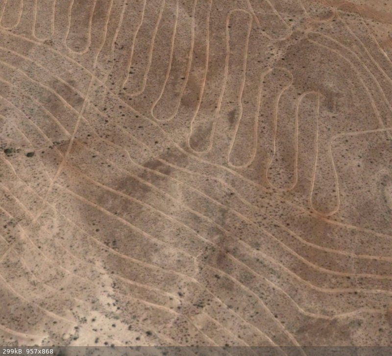
Lines in BCS
|
|
|
StuckSucks
Super Nomad
Posts: 2306
Registered: 10-17-2013
Member Is Offline
|
|
Santa Rita lines
|
|
|
David K
Honored Nomad
Posts: 64486
Registered: 8-30-2002
Location: San Diego County
Member Is Offline
Mood: Have Baja Fever
|
|
A failed Jojoba farm, according to 'rob' at La Aguja (Playas Pacificas). The Santa Rita lines look like the same.
|
|
|
StuckSucks
Super Nomad
Posts: 2306
Registered: 10-17-2013
Member Is Offline
|
|
Good grief, more lines
|
|
|
nandopedal
Nomad
Posts: 167
Registered: 6-1-2010
Location: San Diego Ca
Member Is Offline
Mood: Negra Modelo
|
|
Mega pot farm that was busted a couple of years ago?
\"There are many dangers in Baja. The most serious of which is not going.\" Christophe Noel (EXPO)
|
|
|
tobias
Nomad
Posts: 188
Registered: 1-10-2014
Member Is Offline
|
|
| Quote: Originally posted by David K |
A failed Jojoba farm, according to 'rob' at La Aguja (Playas Pacificas). The Santa Rita lines look like the same. |
Jojoba makes sense ... Jojoba grown by ALIENS maybe
|
|
|
Trunkrack
Junior Nomad
Posts: 30
Registered: 10-3-2021
Member Is Offline
|
|
 Hey Everyone, Hey Everyone,
I've been reading this forum for a few years now but finally getting around to joining and posting for the first time. I'm really curious about these
rock walls or rock lines, whatever you call them. My wife and I stopped and took a photo of them a few years back when taking the high road to San
Juanico. I see that a previous post mentioned erosion control, but was wondering if that was really why they were made? I'm trying to include the
photo (or link to photo), below, but not sure if this will work or not. Hopefully this helps show what they look like from ground level. The photo
quality is not superb, but if you zoom in you can see the lines extend way up the hill. Seems like it would take a tremendous amount of work to build
these.
[img]http:// [/img] [/img]
[Edited on 10-7-2021 by Trunkrack]
|
|
|
David K
Honored Nomad
Posts: 64486
Registered: 8-30-2002
Location: San Diego County
Member Is Offline
Mood: Have Baja Fever
|
|
Great mystery... Baja has many!
Welcome to Baja Nomad, Trunkrack!!
Reminds me of the mystery walls at Bahía las Animas that stumped Desert Magazine's Choral Pepper and Perry Mason creator, Erle Stanley Gardner! https://www.bajabound.com/bajaadventures/bajatravel/lost_jes...
|
|
|
Trunkrack
Junior Nomad
Posts: 30
Registered: 10-3-2021
Member Is Offline
|
|
Thanks David. Yeah, they are similar except for the fact that the image in your article shows the line/wall going straight down the slope, while
these are across the slope, like contour lines as pointed out above. Sure would be cool to know why all this work was done.
|
|
|
David K
Honored Nomad
Posts: 64486
Registered: 8-30-2002
Location: San Diego County
Member Is Offline
Mood: Have Baja Fever
|
|
Walls that have no purpose seem like a government 'make work' project! Las Animas walls are not high enough to direct any animals, they are perfect
for sitting! The lines in your photos are very interesting.
They do look like contour lines.
|
|
|
4x4abc
Ultra Nomad
Posts: 4165
Registered: 4-24-2009
Location: La Paz, BCS
Member Is Offline
Mood: happy - always
|
|
I know of about 20 different locations in Baja with either dozer created or hand stacked elevation lines
30° 3'3.59"N, 115° 0'55.55"W
Harald Pietschmann
|
|
|
Skipjack Joe
Elite Nomad
Posts: 8084
Registered: 7-12-2004
Location: Bahia Asuncion
Member Is Offline
|
|
| Quote: Originally posted by StuckSucks | | Quote: Originally posted by nandopedal | | Ok, last spring when traveling from San Juanico to San Ignacio Lagoon on the "High road" we spotted a series of parallel lines on a slope made out of
rocks, we did not stop and I almost forgot about it but today I started searching on Goggle earth and bingo! Does anybody knows about them? This are
the GE coordinates: (26.5702547,-112.7391995) |
Are those lines of rocks on a hillside? They almost look like contour lines on a topo map.
https://goo.gl/maps/QYj2zaZQDwP2 |
Man made almost certainly. It's just short of San Juan Garcia which at one time was a sizeable agricultural area with a sizable population. Spring
water flows year round.
If you look closely you will notice that where the lines are the earth is bare but where they stop it is all rocky. Therefore the rocks were removed.
The land was cleared and the rocks were piled up into walls, which are the 'lines'.
[Edited on 10-8-2021 by Skipjack Joe]
|
|
|
| Pages:
1
2 |


