| Pages:
1
2 |
eguillermo
Nomad

Posts: 113
Registered: 10-10-2008
Member Is Offline
|
|
Anyone tried GN to Bahia Asuncion via "Bombas de Salinas?"
Sam told Frodo that short cuts make long delays, and that's probably true in this case. But still, I'm wondering -- has anyone tried this alternative
to going around through Vizcaino to get to Bahia Asuncion from the North?
-- Take right off Hwy 1 toward Estero Ojo de Liebre
-- Go left on secondary road that passes through Bombas de Salinas, close by the Laguna
-- Strike the highway between Vizcaino and Bahia Tortugas at a T, and continue right and onward over the usual paved roads.
Maybe that secondary road is full of sand dunes and obstacles? Or maybe it is flat and straight, and could actually save some time. It looks much
more direct on the maps I have. If you know, please let me know  Thanks! Thanks!
|
|
|
AKgringo
Elite Nomad
Posts: 5807
Registered: 9-20-2014
Location: Anchorage, AK (no mas!)
Member Is Offline
Mood: Retireded
|
|
I have not tried to find that route, but if my memory is correct (not a good bet) it was posted on this forum that access is controlled by the salt
processors.
If they are working on that road, they may not allow you in the area. If they are not working there, they have plenty of equipment to make it
impassable.
I also hope someone here has recent information.
If you are not living on the edge, you are taking up too much space!
"Could do better if he tried!" Report card comments from most of my grade school teachers. Sadly, still true!
|
|
|
David K
Honored Nomad
Posts: 64479
Registered: 8-30-2002
Location: San Diego County
Member Is Offline
Mood: Have Baja Fever
|
|
One way to avoid the radar-speed trap on Hwy. 1!
Seriously, it was a popular route in the days before Hwy. 1 was built to Guerrero Negro in 1973.
You should go to the salt company and ask about access. I suspect now with a paved highway to Tortugas from Vizcaino, they won't understand why you
would want to go this shorter but probably longer time-wise route.
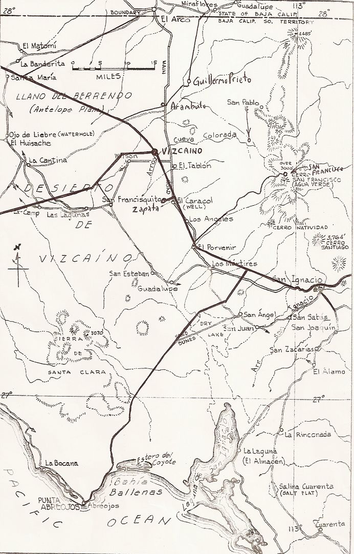
A Nomad did go to the historic waterhole, Ojo de Liebre (from which the Mexicans named Scammon's Lagoon, Laguna Ojo de Liebre). It is located about
mid-way around the lagoon and a few miles east of it using the long way around, in from the salt flats.
I can post more maps and more from old guidebooks on this area if anyone would like to see them.
Here is the 1962 Gulick maps with modern roads drawn in, on the first one... note Ojo de Liebre along the left edge:
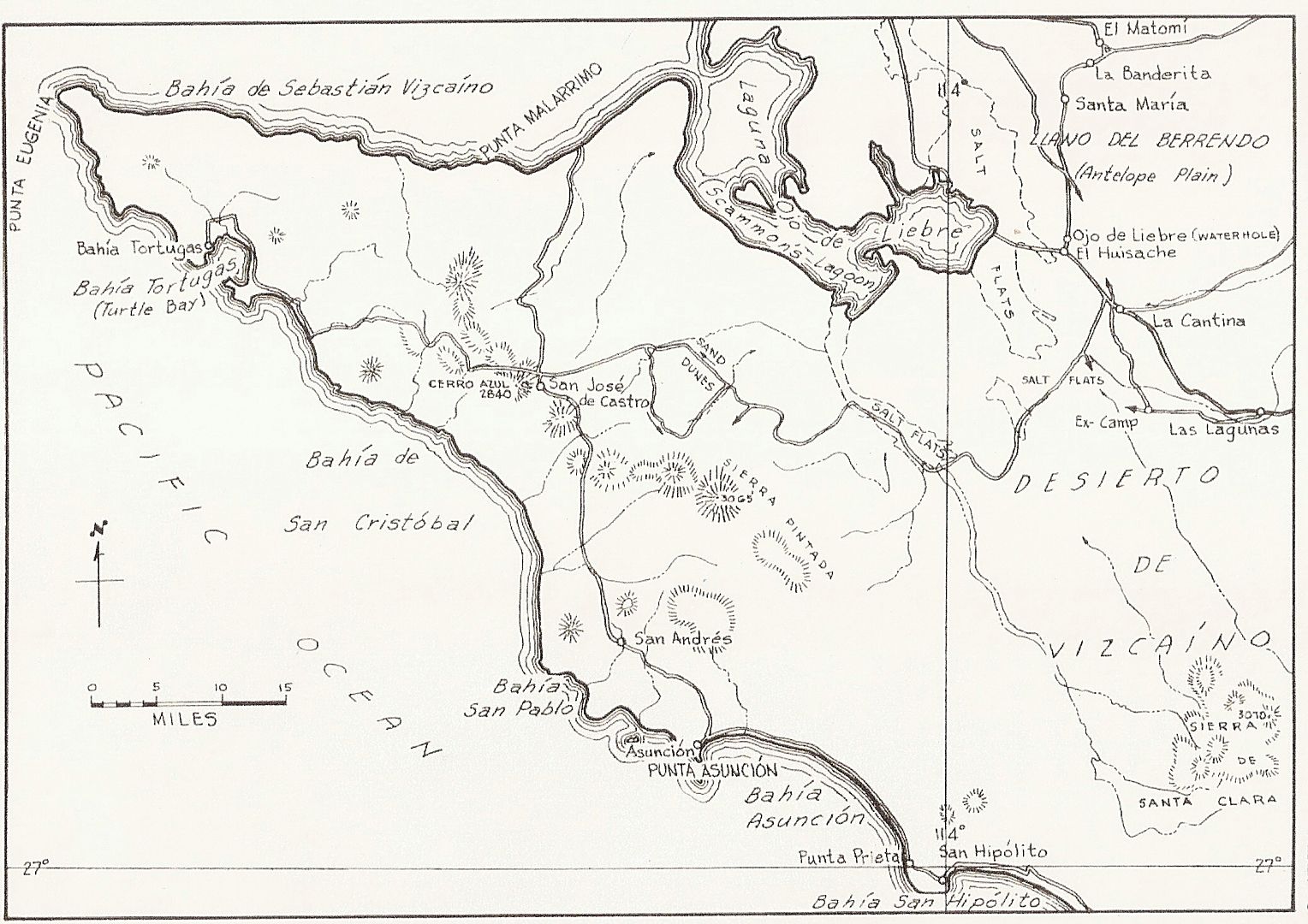
Here is a 1975 map:
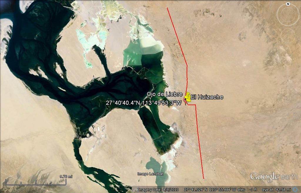
GPS of the spring on Almanac map:
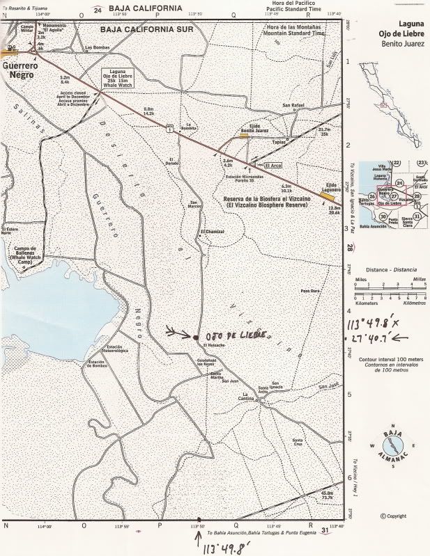
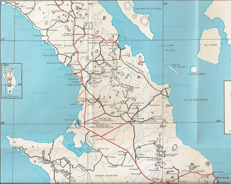
AAA Map of 2010:
Best of luck and please report back what yo0u do get to do!
|
|
|
4x4abc
Ultra Nomad
Posts: 4163
Registered: 4-24-2009
Location: La Paz, BCS
Member Is Offline
Mood: happy - always
|
|
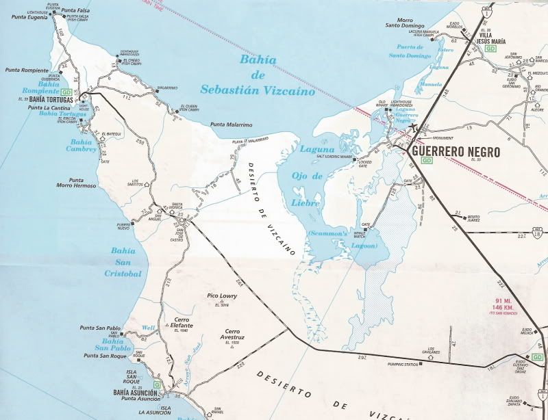
many good roads in that area - this one is best:
http://baja101.com/Baja-GPS/Old4x4.kmz
Harald Pietschmann
|
|
|
fishbuck
Banned
Posts: 5318
Registered: 8-31-2006
Member Is Offline
|
|
If I had one more map...
"A ship in harbor is safe, but that is not what ships are built for." J. A. Shedd.
A clever person solves a problem. A wise person avoids it. – Albert Einstein
"Life's a Beach... and then you Fly!" Fishbuck
|
|
|
motoged
Elite Nomad
Posts: 6481
Registered: 7-31-2006
Location: Kamloops, BC
Member Is Offline
Mood: Gettin' Better
|
|
It is a nice route...was on it yesterday in my pickup....no obstacles to stop you, a few bypasses of wet spots....nice on a bike, as well.
Was out at a rancho eating venison jerky, barbequed chicken and asada....and new friends, Juan and Lilly and their two daughters.
I have used the road several times....the northern entrance I am familiar with is at Rancho Cardon sign....and from the south end a few yards west of
the radio tower at the rebomba
Don't believe everything you think....
|
|
|
shari
Select Nomad
Posts: 13033
Registered: 3-10-2006
Location: bahia asuncion, baja sur
Member Is Offline
Mood: there is no reality except the one contained within us "Herman Hesse"
|
|
the road referred to as close to the lagoon that goes past 8 bombas is not open to the public...there are 2 manned gates that you need a special
permit to go through from the ESSA salt works. It is a wonderful bird watching area but now closed to the public to protect the salt works equipment.
|
|
|
StuckSucks
Super Nomad
Posts: 2306
Registered: 10-17-2013
Member Is Offline
|
|
Same route as 4x4abc, above, embedded in Google Maps. 41km from pavement to pavement.
|
|
|
willardguy
Elite Nomad
Posts: 6451
Registered: 9-19-2009
Member Is Offline
|
|
Quote: Originally posted by shari  | | the road referred to as close to the lagoon that goes past 8 bombas is not open to the public...there are 2 manned gates that you need a special
permit to go through from the ESSA salt works. It is a wonderful bird watching area but now closed to the public to protect the salt works equipment.
|
this is a different road than the one Ged speaks of?
|
|
|
JZ
Elite Nomad
Posts: 9228
Registered: 10-3-2003
Member Is Offline
|
|
Is this one open?
[Edited on 12-17-2018 by JZ]
|
|
|
BajaRun
Nomad
Posts: 222
Registered: 2-25-2012
Member Is Offline
Mood: Just Cruisin'
|
|
I took the "Antenna" road 2 weeks ago. Came from El Arco down the wide graded road. Crossed the Hwy 1. Opened and then Closed the gate.
It was a nice ride. Dropped us out by the antenna on the other end. No water or mud.
It was my first time on this route. I missed a couple turns and ended up at some ranchos a couple times. I don't use GPS. Old School adventure style

|
|
|
motoged
Elite Nomad
Posts: 6481
Registered: 7-31-2006
Location: Kamloops, BC
Member Is Offline
Mood: Gettin' Better
|
|
Yes, as said previously....Shari is referring to tracks closer to lagoon and salt works....
Don't believe everything you think....
|
|
|
David K
Honored Nomad
Posts: 64479
Registered: 8-30-2002
Location: San Diego County
Member Is Offline
Mood: Have Baja Fever
|
|
Here is Harald's map. I added the GPS point of Ojo de Liebre spring. I do not know what "Starting Location" is. That was on Harald's map.

|
|
|
motoged
Elite Nomad
Posts: 6481
Registered: 7-31-2006
Location: Kamloops, BC
Member Is Offline
Mood: Gettin' Better
|
|
The northern entrance to the road is south of the Ojo de Liebre Road
Don't believe everything you think....
|
|
|
motoged
Elite Nomad
Posts: 6481
Registered: 7-31-2006
Location: Kamloops, BC
Member Is Offline
Mood: Gettin' Better
|
|
David K said:
"Seriously, it was a popular route in the days before Hwy. 1 was built to Guerrero Negro in 1973.
You should go to the salt company and ask about access. I suspect now with a paved highway to Tortugas from Vizcaino, they won't understand why you
would want to go this shorter but probably longer time-wise route....."
My experience, having traveled it recently has no need for suspicion:
It is shorter and quicker....some local work trucks use it regularly, as well as some other locals....and I am not sure that is all saltworks
property...so asking for permission is not needed.
So let the guessing continue, or find it and enjoy it.
[Edited on 12-17-2018 by motoged]
Don't believe everything you think....
|
|
|
David K
Honored Nomad
Posts: 64479
Registered: 8-30-2002
Location: San Diego County
Member Is Offline
Mood: Have Baja Fever
|
|
| Quote: Originally posted by motoged | David K said:
"Seriously, it was a popular route in the days before Hwy. 1 was built to Guerrero Negro in 1973.
You should go to the salt company and ask about access. I suspect now with a paved highway to Tortugas from Vizcaino, they won't understand why you
would want to go this shorter but probably longer time-wise route....."
My experience, having traveled it recently has no need for suspicion:
It is shorter and quicker....some local work trucks use it regularly, as well as some other locals....and I am not sure that is all saltworks
property...so asking for permission is not needed.
So let the guessing continue, or find it and enjoy it.
[Edited on 12-17-2018 by motoged] |
Thank you, Ged, but before I saw the map from Harald and StuckSucks, I was presuming the route mentioned was using the company roads that drive across
the salt pans, next to the lagoon. A desert road not over salt evaporation pans is certainly not a concern with the salt works.
The roads mentioned later (per the Google Earth map images) is far from the lagoon and does not begin on the whale watch road.
The OP (eguillermo) posted this. :
-- Take right off Hwy 1 toward Estero Ojo de Liebre
-- Go left on secondary road that passes through Bombas de Salinas, close by the Laguna
[Edited on 12-17-2018 by David K]
|
|
|
motoged
Elite Nomad
Posts: 6481
Registered: 7-31-2006
Location: Kamloops, BC
Member Is Offline
Mood: Gettin' Better
|
|
Shari clarified the question about saltwork roads close to lagoon; Harald's map clarified the route that I commented on.....and as per your maps
(Almanac mostly), the term used by the OP could describe a lot of the tracks in that general area south of GN, knowing the off-limit areas are not to
be considered for travel....and I believe they post that in some places.
The helpful part of the thread is some people might enjoy the road Harald's map points out.... no 4x4 needed....any car could do it...
Don't believe everything you think....
|
|
|
eguillermo
Nomad
Posts: 113
Registered: 10-10-2008
Member Is Offline
|
|
Thanks everyone! The nomads do take their roads seriously
If a chunk of time opens where I need to rest my kayaking back, I might just try some of that. I do plenty of sitting around on a Baja trip, mostly
in a gravity chair; but why not spend some of that time finding new routes, right?
I'm giddy because I think I just found out that I can get out of work a whole day earlier and start down Wednesday. Viva Baja!
|
|
|
4x4abc
Ultra Nomad
Posts: 4163
Registered: 4-24-2009
Location: La Paz, BCS
Member Is Offline
Mood: happy - always
|
|
OK
tweaked it to be Antenna Road
http://baja101.com/Baja-GPS/AntennaRoad.kmz
it now ends/starts at the antenna
and David, there is no "Starting Location" in my file
looks like you have a Russian bug on your PC
Harald Pietschmann
|
|
|
JZ
Elite Nomad
Posts: 9228
Registered: 10-3-2003
Member Is Offline
|
|
Can someone mark the spot were Shari's whale tours launch from?
|
|
|
| Pages:
1
2 |


