| Pages:
1
2
3 |
David K
Honored Nomad

Posts: 65241
Registered: 8-30-2002
Location: San Diego County
Member Is Offline
Mood: Have Baja Fever
|
|
You yourself said "without the Almanac errors". The Almanac is made from Mexican government topos with some additions.
Yes, H11B87 is wrong, Arroyo Zamora is incorrect. It is Arroyo el Volcán.
Go to H11B88 and see that they applied Volcán to the next arroyo south, in error.

|
|
|
David K
Honored Nomad
Posts: 65241
Registered: 8-30-2002
Location: San Diego County
Member Is Offline
Mood: Have Baja Fever
|
|
At El Volcán, 4 mi east of El Mármol
Error on H11D17, "Zamora" instead of El Vocán, right at the geyser...

|
|
|
4x4abc
Ultra Nomad
Posts: 4430
Registered: 4-24-2009
Location: La Paz, BCS
Member Is Offline
Mood: happy - always
|
|
but which authority says its wrong?
guess I have to go to the INEGI office
Harald Pietschmann
|
|
|
4x4abc
Ultra Nomad
Posts: 4430
Registered: 4-24-2009
Location: La Paz, BCS
Member Is Offline
Mood: happy - always
|
|
H11B88 and H11B87 match just fine

Harald Pietschmann
|
|
|
David K
Honored Nomad
Posts: 65241
Registered: 8-30-2002
Location: San Diego County
Member Is Offline
Mood: Have Baja Fever
|
|
I never said the maps didn't match, but the one on the right has A. el Volcán printed right below Zamora.
El Volcán is the geyser (onyx soda spring) east of El Mármol... The arroyo it is in would be the one named Vocán.
The also goofed with the name of Bahía San Luis Gonzaga and Ensenada de San Francisquito, reversing those two bay's names.
|
|
|
norte
Super Nomad
Posts: 1163
Registered: 10-8-2008
Member Is Offline
|
|
Excellent job 4x4. Way better than other attempts at mapping.
|
|
|
4x4abc
Ultra Nomad
Posts: 4430
Registered: 4-24-2009
Location: La Paz, BCS
Member Is Offline
Mood: happy - always
|
|
David, do you have a good map showing us the correct names of Bahias and Ensenadas around Gonzaga?
Harald Pietschmann
|
|
|
4x4abc
Ultra Nomad
Posts: 4430
Registered: 4-24-2009
Location: La Paz, BCS
Member Is Offline
Mood: happy - always
|
|
the name game on topo maps is never ending
not only do they change names every other decade or so - they also have names in places where you think they should not be (ran into that many times
in Baja) - but they are the maters and we have to use what they present us with.
And then there are the map maker's games
they add phantasy names wherever they like
Landon Crumpton (Baja Almanac) was a master
AAA had some pretty creative names for places as well
I am sticking what is on the official Mexican government topo maps
on occasion I add names that the Gringos have created
not instead but parallel
a map is not an opinion piece - it is a collection of facts
Harald Pietschmann
|
|
|
David K
Honored Nomad
Posts: 65241
Registered: 8-30-2002
Location: San Diego County
Member Is Offline
Mood: Have Baja Fever
|
|
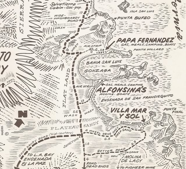
I think that is the only issue Harald... the smaller, harbor-like bay between Papa Fernandez' and Alfonsina's is the true Bahía San Luis Gonzaga...
some call it Willard Bay after the U.S. Navy H.O. Chart designation. The bigger, more open bay to Punta Final is the Ensenada de San Francisquito,
named after the gold ore mill, now called Molino de Lacy and the place where the ore was shipped from (Puerto de San Francisquito, which is now the
tourist campo, Punta Final. With a name like that, you can't blame anyone for simply calling it "Gonzaga Bay" too!
PS, some the island names have been changed from what the maps called them.
|
|
|
4x4abc
Ultra Nomad
Posts: 4430
Registered: 4-24-2009
Location: La Paz, BCS
Member Is Offline
Mood: happy - always
|
|
totally agree with you David
Harald Pietschmann
|
|
|
4x4abc
Ultra Nomad
Posts: 4430
Registered: 4-24-2009
Location: La Paz, BCS
Member Is Offline
Mood: happy - always
|
|
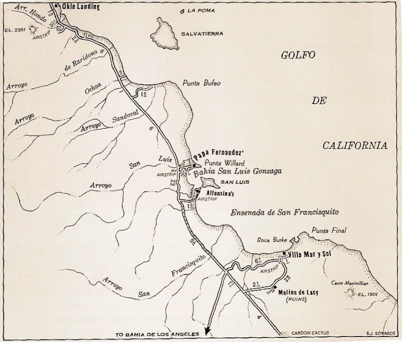
that map is a good example.
None of the Arroyo names seem right - or they have been changed as well.
And Cerro Maximilian EL 1901? No significant mountain in that area. And the hill that the map indicates is 2230 ft according to GE.
But anyway - the B.J. Edwards map seems interesting. Do you have more?
Harald Pietschmann
|
|
|
geoffff
Senior Nomad
Posts: 709
Registered: 1-15-2009
Member Is Offline
|
|
Wow, I'm super-excited for this project!
Though you are way more traveled than me, I'm happy to review your maps on the off chance there's somewhere I've been that you haven't.
What to omit? This can be a polarizing topic. When I post things, people have asked me to omit the exact locations of rock art, and also sometimes hot
springs (such as El Palomar canyon off Laguna Salada). I tend to agree.
-- Geoff
|
|
|
David K
Honored Nomad
Posts: 65241
Registered: 8-30-2002
Location: San Diego County
Member Is Offline
Mood: Have Baja Fever
|
|
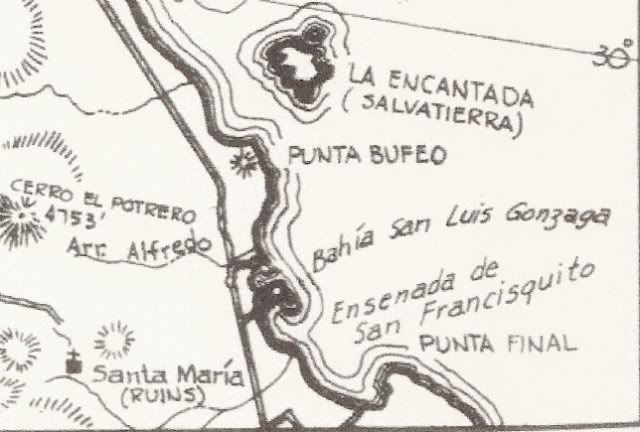
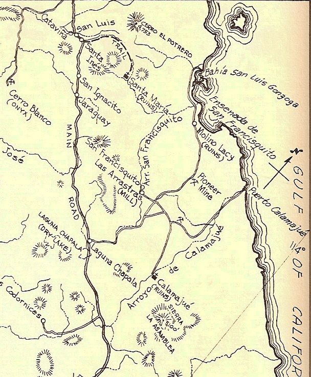
That map was in the Auto Club's Baja Norte guidebook (1968-1973). The arroyo named 'San Francisquito' reaching the Ensenada de San Francisquito (on
the map) is actually the south fork (today called Arroyo Las Arrastras) and the one coming down from the west it joins with is really Arroyo Santa
María... all the way to the bay.
Here's a map from 1930, note the name at Lacy's Mill...
All the area names of San Francisquito originate with the waterhole on El Camino Real, originally named "San Francisco" and written about by Junípero
Serra in 1769. The water hole was very near Las Arrastras, just downstream and around the corner before going under the new Hwy. 5 bridge, north of
Las Arrastras.
Here it is on a 1956 map:
|
|
|
norte
Super Nomad
Posts: 1163
Registered: 10-8-2008
Member Is Offline
|
|
Quote: Originally posted by 4x4abc  | the name game on topo maps is never ending
not only do they change names every other decade or so - they also have names in places where you think they should not be (ran into that many times
in Baja) - but they are the maters and we have to use what they present us with.
And then there are the map maker's games
they add phantasy names wherever they like
Landon Crumpton (Baja Almanac) was a master
AAA had some pretty creative names for places as well
I am sticking what is on the official Mexican government topo maps
on occasion I add names that the Gringos have created
not instead but parallel
a map is not an opinion piece - it is a collection of facts |
Shouldn't mapmakers use the official names for places to avoid confusion? A new ranch or ejido pops up and the name changes...or a camp site is
created and a name pops up. An excellent example is the use of "shell Island" on some maps. That is one of those fantasy names. There is no such
place and therefore should not be on a map.
[Edited on 1-23-2019 by norte]
|
|
|
4x4abc
Ultra Nomad
Posts: 4430
Registered: 4-24-2009
Location: La Paz, BCS
Member Is Offline
Mood: happy - always
|
|
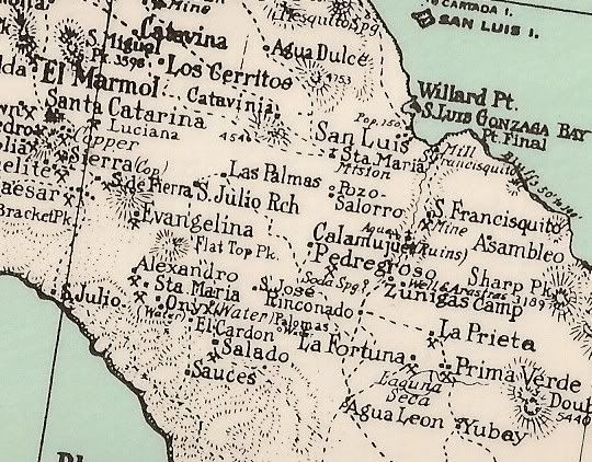
I was always intrigued by "Pozo Salorro" on that map
still don't know which well/spring it is
Harald Pietschmann
|
|
|
4x4abc
Ultra Nomad
Posts: 4430
Registered: 4-24-2009
Location: La Paz, BCS
Member Is Offline
Mood: happy - always
|
|
considering that those maps are hand drawn, it is probably Las Palmitas
Harald Pietschmann
|
|
|
4x4abc
Ultra Nomad
Posts: 4430
Registered: 4-24-2009
Location: La Paz, BCS
Member Is Offline
Mood: happy - always
|
|
for a long time I was also trying to find Calam spring - today it hit me, they must have meant Calamajue spring
Harald Pietschmann
|
|
|
geoffff
Senior Nomad
Posts: 709
Registered: 1-15-2009
Member Is Offline
|
|
Harald, I don't know if it'd be useful to you, but I have put together the INEGI 50K and 250K topo maps for all of Mexico. I just put them here on my
website:
https://topogeek.com/mexico/
It shows 250k when zoomed out, and 50k when zoomed in. You can Google-search by place name or lat,lon in the lower left input box.
-- Geoff
|
|
|
David K
Honored Nomad
Posts: 65241
Registered: 8-30-2002
Location: San Diego County
Member Is Offline
Mood: Have Baja Fever
|
|
OMG Geoff... that is fantastic!!! May I link to it on VivaBaja.com?
WOW, incredible work...
|
|
|
geoffff
Senior Nomad
Posts: 709
Registered: 1-15-2009
Member Is Offline
|
|
Actually, no, please let's not for now. This is temporary. It's on my cheap Dreamhost server which can't handle a lot of traffic.
I'm working on getting these maps a better home sometime in the next year.
-- Geoff
|
|
|
| Pages:
1
2
3 |


