| Pages:
1
2
3 |
PaulW
Ultra Nomad

Posts: 3005
Registered: 5-21-2013
Member Is Offline
|
|
Arroyos Near San Felipe
Baja Arroyo and Reference for explorers, Near San Felipe –
-Original 7/2013, Revised 7/2015, Revised 1/2019, 4/6/2021
- Arroyo/Wash report for San Felipe area. East of the mountains.
- I started exploring over 14 years ago and have slowly compiled GPS tracks for these arroyos.
- This write up describes highlights what I know about each one.
- What you read below is current as of when I drove the tracks
- My starting place for my exploration was discussions with Bruce Barber, Lou Wells. For details on many of the placed I describe please refer to
Bruce Barbers’ book “--- of Sea and Sand.”
- Many of the trips listed were located and identified using Google earth and subsequently driven.
Starting from the North with Notes/Comments Significant roads are noted
Arroyo La Ventana, And the place. Name means window. Largest window location is N31-42.912, W115-08.5014 about 5 miles west of Hwy5 Access is Hwy5
K106.4. N31-43.854’, W115-03.862’. Graded road leads W to several mine wells. The well place is properly named by INEGI as Tres Pozos. These wells
are sometimes called Arroyo Grande wells and the count is now 4. The main well place is at N31-42.126’, W115-15.316’. Turns out there are many
more Ventana’s (Windows). Seems like it’s easy for find hole in the volcanic rocks. Originally it was found by Howard Gulick during his research
for his guidebook in the 50's. His location for La Ventana is at N31 43.109’, W115 2.288’
Another one Bruce Barber found one southwest of the first one described by Gulick and surely is bogus? These windows have still not been located by
myself or anyone else I know. Area has a huge number of cuervitas (small caves) and many of them could be called windows. And there is at least one
other window on a SW skyline, but it is so far from La Ventana I have discounted it.
Arroyo Grande Leads S from the mountains N of Hwy3 to Lugna Salida from La Ventana road at the mine wells at N31-42.126, W115-15.316 and heads S
toward Mx3. I found one report that someone was able to pass thru the heavy vegetation past my dead end at N31-27.086’, W115-26.554’ which is
after the remains of the dam. Access at Hwy3 K152.7 is a locked gate at N31-18.087’, W115-25.680’. To get to Hwy 3 several substantial locked
gates will be found.
Huge vertical walls, great drive to the heavy vegetation.
Pinta Pass. Chinero Pass is a more formal name used by the cartographers, but not the favored name. Referred to as “SCORE Track West” It is a
north south arroyo exiting Arroyo Grande track at N31-37.472’, W115-15.538’ and leads E to another wash route south to Borrego. This one is
usually referred to as the SCORE route. Also called Borrego Pass by some. “Pinta Pass west” is another good descriptive name.
“Pinta Pass East” An unnamed canyon drainage that Leads S from La Ventena/well road at N31-42.178’, W115-10.810’ east of the wells and heads S
to Borrego. Referred to as "CODE track”. Parallels Arroyo Grande & Pinta Pass west and combines with Pinta Pass west. Both tracks join north of
then pass thru 4 corners at N31-25.644’, W115-11.029’ below the military camp (ab).
Arroyo Jaquegel Currently shown on the modern maps. (5 names) Known as "The Pole Line Road", “Arroyo El Tule”, Telephone Line (road), and Buck
Canon. Traveling west the Jaquegel trail begins in Arroyo Grande at N31-37.54922’, W115-15.71430’. The arroyo leads to the W and heads over the N
summit (N summit is better known as the race summit) to Hwy 3 between Indepencia and Valle Trinidad. The race summit is now closed with a substantial
locked gate. Meanwhile a new route that avoids the locked gate at Arroyo Siaz and the huge cable fence has been found. It uses a road going N from
White Tank and leads to Mano junction via Arroyo Enmedio.
The 1905/1919 Nelson map is the only source found for the Tule name. However several published writings use the Tule name. The Arroyo road and
“Telephone Line” were created in 1942 to service the US radar facilities located in San Felipe and Punta Estrella. As of spring of 2019 the route
is passable via a difficult trail. Some of the cobble stones and poles from the original road still remain. The west end of this trail passes over the
main summit above and NE of Jamau (and is no longer passable by any kind of vehicle). That abandoned summit is called “Jamau” and is the south
summit. (N31-36.05, W115-36.4). The north summit (race summit or North summit) is at N31-37.631, W115-36.624’ And is shown on the older maps as
“Portezuelo de Jamau”. There is still another summit we have been calling the middle summit, but its proper name should be “Siaz” after the
major drainage leading north from the summit. Its location is N31-36.05, W115-36.40. The road over Siaz summit is presently unknown. The route has a
locked gate on the south side of the summit. All three of the summits are found from the Pole Line Road or trail. The Indian trail from Chinero over
Pinta pass and over the mountains is called “Buck Canon Trail” on the 1930 map by Knight. All 3 summits are no longer passable. South too hard,
heavily eroded. Middle and race summits have locked gates.
Arroyo El Arrajal Leads west from hwy5 K133.8 at N31-29.624, W115-04.249and allows connection of Mex5 to Mex3.
Route passes thru the 4 corners at N31-25.644, W115-11.029 just north of the old military camp (ab). Leave the arroyo and head S near N31-24.738,
W115-21.417. At the summit is an abandoned air strip actually in the silt bed? From Hwy 3 at K159.8 N31-17.286, W115-21.259 drive N thru the gated
fence.
"Slate mine rd" Leads N from Hwy 3 K160. Turn NE off the El Arrajal road at N31-19.600, W115-21.344. Road ends at mine. Recommended easy drive.
“Unnamed Wash” Starts at Hwy3 K160 and heads S to the north end of L Diablo. Wash continues N across the fence to the Slate mine area.
“Tres Pozos” Name means 3 wells. INEGI and Almanac are wrong. Tres Pozos is actually north at the mine wells. Access to this arroyo is via the
race road Hwy3 K179.3 N31-21.991, W115-11.282.
Wash leads NW at Borrego at Hwy3 K181.1 N31-22.728, W115-10.512. Wash crosses the race track N31-23.080, W115-11.198 & ends in the arroyo to the
west.
This arroyo is full of impassable large boulders at the point where the canyon narrows.
“3 Poles wash" Official INEGI name is Borrego, means Lamb. Generally parallels Hwy 3. Heavily traveled by racers. Deep sand and multiple paths. Very
wide. Access at 3 Poles is Hwy5 K142 N31-25.497, W115-02.750. But most common access is K149.4 N31-21.747, W115-01.002 then head N following one of
the race tracks.
Arroyo Las Cuevitas means little caves. Some locals call it "Calamity". Access is Hwy5 K149.4 N31-21.747, W115-01.002 and leads west via gravel pit. A
common duplication of names.
Leads west to Villa del Sol road (the graded road that leads to L. Diablo).
"rock crawl exit" Also known as "Smugglers route". High clearance required.
Leads NW from Cuevitas at N31-17.423, W115-10.244 to hwy3 at K174.8 at N31-18.900, W115-13.210
"Gypsum mine" Also called "Mica Mine". No mica, but lots of selenite gypsum crystals. Leads NW from Cuevitas at N31-20.798, W115-05.028 to the mine.
Interesting drive.
"unnamed" Arroyo leading NW from Cuevitas approx N31-21.067, W115-04.688. Several failures to reach Hwy3. Unverified needs exploration.
"Lunch" Unnamed wash leads E from Cuevitas N31.28032, W115.16275 The popular Sea of Cortez overlook lunch place. N31-16.826, W115-09.822. All arroyos
from this main wash are short and dead ends.
“21SF track”?
"Mini Summit" Alternate names are "Telegraph Pass" & "Power line pass".
Summit is N31-10.682, W115-08.547. Major 15’ drop-off is at N31-10.541, W115-08.075
From 2 poles, Hwy5 K166/7 N31-13.362, W114-56.924, follow race track SW or W to power line NW - summit - to Villa del Sol Rd.
Since hurricane Nora - Impassable for normal rigs. In 2011 3 Jeeps made the crossing with extensive use of winches (E to W). Several hardy moto guys
have made the crossing in the last few years (W to E). Summit is reachable from the west by following the metal power line from Villa del Sol road.
Good drive.
Update - 5 of my buddies all in Jeeps traveled east successfully. Winches were required to get over and around the huge boulders. Took all day.
Arroyo Las Almejas (Also arroyo Arena means sand) Name means clams. Wholly within El Dorado ranch, Leads W from the N/S power line Approx. at
N31-07.807, W114-54.662. Not proper to drive, but we have walked it many times. It's very wide, North of subdivisions RDS/PVN/LMN/LVN.
The east end is used by the buggy rental concession. 21 Sf 250 used this arroyo.
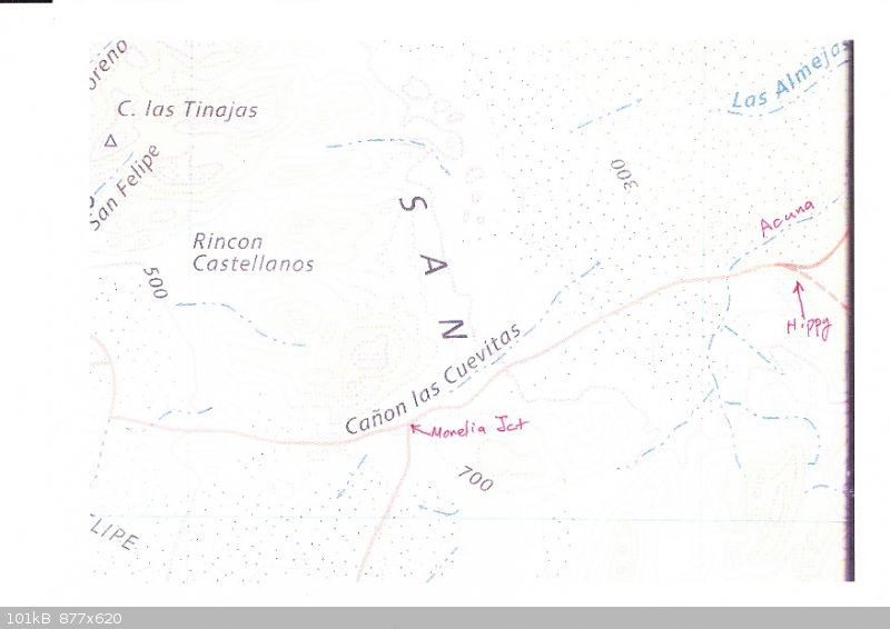
"Saltito" Official INEGI name is Canon las Cuevitas. (name duplication) Also called "Zoo Rd" & "Morelia Rd". Starts at the ARCO/OXXO and passes
thru the Eldorado security entrance. Graded road used for west valley access. Starts at the west El Dorado formal entrance & PMEX & the El
Dorado resident entrance at K178.5 N31-07.033, W114-54.003.
Public access is a new paved road called Morelia Rd starts at K181.2 N31-05.902, W114-53.577 at the storage place near K182. Roads join near the power
line at N31-04.534, W114-57.808. This part of the road is now paved from Highway 5 for 10km. The west part for Canon las Curevitas drainage is
westerly The east end drainage is eastward and becomes Acuna then and Los Almejas
"Power line" Access from Saltito leads N & S from Saltito Rd. Used for the race track. Crossing is at N31-04.515, W114-57.866
~
Arroyo Acuna# means cradles. Begins at ~N30 57.7, W115 3.5 and at ~N30 59.3, W115 0.5. Leads NE, crosses Saltito/Morelia Road then crosses the Power
line and becomes A Las Almeias (Arena) or is next to it as one big wash.
"dump road" Access from Saltito leads south east at N31-04.307, W114-58.514 from hippy camp past the dump then to the arches. This used to be the
main road from south of Hwy 3 using the connector diagonal to San Felipe.
Arroyo Davalos# No description
Arroyo Hellin# No description
"Rams Head" Access from Saltito leads S at N31-03.631, W115-01.331to "Rams Head" then west to Morelia road or SW to Chanate. Choke point is
N31-01.190, W115-01.160. No INEGI name. High clearance rig is good. (See ATV track below). Intersects Chanate at N30-54.004, W115-03.052
"Highlands" Just a land mark of an abandoned community. Leaves Saltito leading N at N31-02.996, W115-03.018. Access beyond to interesting places like
Diatoms, chalk mine then on to 4 corners at the power line via the Connector Diagonal.
"Connector Diagonal” Leads N from Saltito at N31-03.072, W115-02.844. This is the old main road thru 4 corners at the power line then to Hwy 5.
Arroyo Amarillas means yellow. Some locals call it the arroyo leading to “Hidden Valley" or "Lost Valley" (dead end). Begin at OPR N30-55.81,
W114-50.142.
"Cross Over" Access leads south from Amarillas to Chanate. Also called the "Connector". High clearance required. Leave Amarillas near N30-52.402,
W115-00.230. And reach Chanate at N30-51.187, W114-59.256
Arroyo Chanate (Chanote) means blackbird. Leads to west valley past Quartz Mtn at N30-53.510, W115-04.220.
Find access at OPR N30-53.379, W114-549.793. Locals have used the name Emerald canyon and has a landmark called Quarts or Crystal Mountain.
"ATV Track" Access leads N from Chanate at N30 54.005, W115-03.051 and heads to Morelia road near N30-56.389, W115-07.206. Intersects Rams Head at a
Rams head turn to the NE at N30-56.521, W115-06.237. ATV track continues straight instead of the turn to Ram Head.
“WOW” No official name. Wash is loop from Chanate to Chanate. A path from SE of the junction of Rams Head & Chanate and enters the wash. Good
drive. Heading easterly the entrance in Chanate is near N30-52.95, W115-02.01. Several difficult tracks at that point to sort out. From the SW side of
Chanate drive SW then SE to find the track. The end of WOW is near N30-51.384, W115-00.136. Find a 5+ foot spill over. In the past the spillover has
been full of rocks and was passable by ATV via narrow crack. A rock crawl Jeep may be able to drive over the spill over??
Enter the loop from the east at N30-51.194, W114-59.284 and drive SE. The track then curves back to a western heading then follow the arroyo to the
spillover. A Cardon forest is at the big curve.
Arroyo Huatamote name of a plant. Some locals incorrectly call it "Percebu" because it was wrongly shown on older maps. Proper arroyo has been
impassable to the west valley for many years. Named for a Baja bush. Access to west valley is n to a branch pf Parral. "Seep Willow [huatamote]
(Baccharis glutinosa)"
See baccharis glutinosa seep willow Guatamote (Huatamote)? The plant is used as a traditional medicine.
There is another Arroyo with the same name in Baja Sur and many places in Baja use the name Huatamote.
Start Hwy5 K20.7 N30-49.180, W114-44.552 Or start at Old Puertecitos Rd at N30-49.388, W114-48.794 and drive west.
Arroyo Parral means vineyard or grapevine Leads south then west from Huatamote at N30-45.564, W115-00.807. One of many INEGI official Parral paths.
This arroyo is the only passable way to the west valley using Huatamote.
Many water paths are called Parral & cross each other. They primarily drain overflow storm water from the west valley.
Arroyo Don Pancho Crosses Hwy near K16
Arroyo Percebu means barnacle. Starts near the coast and ends in the desert west of hwy5. Crosses the Hwy at ~K22 & K22.2
Arroyo Auga de Chale Crosses Hwy near K31
Arroyo Aleuri# From campo Perlita crosses the hwy at ~K36.7 and ends east of the hwy. Look north of hwy at N30 40.814, W114 42.3
Arroyo Jimenez# From Campo Cadena crosses the hwy at ~K42and ends west of the hwy. Look on the hwy at N30 38.105, W114 42.34
Arroyo "Azufre" means Sulfur. Official INEG name is Parral (another duplication). Locally known as "Crazy Horse". Access from Hwy 5 K34.3 at N30-42.1,
W114 42.768, Access from Old Puretictos Rd at N30-41.732, W114-46.509. Find Apache Tears at the wash entrance at 30 38.22, -114 49.65.
Arroyo "Terry" Starts at Hwy5 K54.2 N30-32.061, W114-41.688 & ends up in Matomi at N30-30.015, W114-48.548 or cross country to the Matomi N exit.
Named after the birthday guy. No INEGI name. High clearance required.
Arroyo Matomi Entrance is Hwy5 K60 at N30-29.354, W114-40.008. Follow any of many tracks. Connects to west valley road south of valley Chico. Named
after Rancho Matomi/Ejido Matomi. Arroyo eventually leads west to Rancho Matomi.
At the narrows passage is difficult. No travel between summer of 2012 and Jan 2015. Jeeps or high clearance vehicles with 4wd shouldn't have a
problem. Access to rancho Matomi is good from Valley Chico & the west valley road, however access to Rancho now blocked with a locked gate as of
2021.
Arroyo Los Blancas (Barraca) means white. Leads SW from Matomi at N30-29.670, W114-50.099 into Canelo valley. Name means Cinnamon. Drive into the
"Canelo Preserve" & to natural arch at N30-27.629, W114-55.548.
"North Exit race road” Leads north from Matomi. Leave Matomi at N30-29.786, W114-50.169. Connects north to Azufre, old Pureticitos road (OPR), and
Apache Tears.
Arroyo El Canelo (Padilla) means Cinnamon. Many paths from Hwy5. Exploration needed. Look near K63/64 N30-27.443, W114-39.397
Access unknown. Expect deep soft sand.
Arroyo "Unnamed" Many washes further south. New HWY blocks access to many.
Notes:
*All coordinates are in the format of degrees and minutes and fractions of minutes. Datum is WGS 84.
* The Villa del Sol graded Rd leads S from Mx3 K163 N31 16.812, W115 19.070 and heads toward "Juan's" store, Chinalilito, & Santa Clara on the
east side of L Diablo. Eventually connects with Saltito Rd at Morelia Jct. Juan is gone and the place is abandoned.
* Every year Huatamote and Matomi change drastically due to major flooding from summer storms. Often impassable.
* The use of GPS with background maps is the best way to locate the roads to the arroyos
* GPS Maps are sold by Murdocknav.com for Lowrance & Garmin. Other suppliers can be found specifically for Garmin GPS. None are as complete as
Murdock.
* Topo maps are no longer available at the INEGI office in Mexicali. Instituto Nacional de Estadistica y Gergrafia. PDF versions can be downloaded
free from the INEGI web site.
* Please do not try to drive these arroyo places unless you have low range 4WD and high clearance and the usual recovery equipment.
* A GPS is required to find the pertinent places in my write-up. All Coordinates shown are WGS84 Datum. Converted from previous editions of this
document. And are now the same as Google Earth.
If you wish to plot the points on the Almanac or the old INEGI maps you must convert to the Datum to “North American 1927-Mexico”. INEGI maps are
compatible with WGS84. In my experience using the wrong datum on your GPS will result in about a 200 - 400 foot error. Not good if you are looking for
a hard to find place.
* Kilometers noted were created by driving Oct-Dec 2014 and published by Murdock Aug 2014.
* 95%+ of these arroyo back roads are pictured on the Murdock GPS maps which are updated before every SCORE race.
# Arroyos found on a 1975 map and are not found on later maps
If anyone has comments on this report contact Paul Wilson
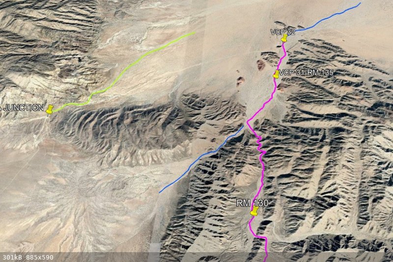
Some GPS Screen shots for areas discussed above follow.
Please note while GPS screen shots are useful for knowing where the roads are and how they all interact. You can use Google earth or Bing with the
coordinates provided and see a better picture of the terrain and you can detect the roads and washes by looking at the screen shot at the same time as
you look at the sky views. I highly encourage the use of GE & Bing for more knowledge. PW
Common notes:
R always designates a race road
OPR is old Puertecitos Road
Handwritten X means do not drive road is blocked or not passable. These tracks represent my errors of trying to drive where I should not have been or
could not pass due to cliffs.
N Area - 1
K77.2 is marginal at times due to water and bad mud
K86.8 is a graded road.
K89.2 leads to a smooth road.
Drive down the shoulder to the cut in the fence
K92 leads to a race road

N Area - 2
H is a track along the hills in the sand dunes
Cross hairs locate the Ventana (Window). N of the graded road
PLR Wash is the beginning of Arroyo Jaquegel
(PLR means Pole Line Road. 1942 Telephone line)
M is the west access road for the big mine on the east side of the Pintas
Pipe line has a very bad road.

N Area - 3
M Many small mines shown along the W mine road
AG is Arroyo Grande
P P is Pinta pass - the historical narrow canyon that passes between the San Felipe and the Pinta mountains. - now days used as a race road. Historic
route from Chinero to Arroyo Grande. Chinero is the area near K133
P P/E is Pinta Pass east another N-S Race road
Crosshair is the south end of the crossover between the two passes. Track goes thru a saddle in the hills.
Green X are waypoints not an X to note “do not drive”.
WPL it the wood power line track

N Area - 4
K133.8 leads to the race roads and Arroyo Arrajal “A”
SM is the slate mine below C. Borrego
3P k142 is three poles
2P k163 is two poles
4C is four corners
K179 is the N Borrego race road beginning.
DS is Villa Del Sol Road leading to L Diablo
MS is the Mini Summit
PL is the metal power line
WPL is the wood power Line
RC is the rock Crawl access to Cuevitas
OX is the Memorial at N31 15.38, W115 19.58
P are various Pete’s poker run tracks

Central Area – 5
Wash is Las Almejas
RH is the north area of Rams Head
4C is another four corners.
HL is the abandoned Highlands community.
The east end of Zoo road is the PMEX at K179
D is the dump road
P is Pete’s camp poker run
HC is the Hippy camp

Central Area – 6
RH is the choke point in Rams Head
A is the junction of Rams Head & Chanate
H is the Hudus
The big Blue X are just waypoints. Not a blocked road.

Central Area – 7
C is the easy access to Chanate (keep to the N track)
N30 53.4, W114 49.8
B is the junction of Chanate and WOW

Images 8, 9 & 10 follow next post
[Edited on 1-30-2019 by PaulW]
[Edited on 1-30-2019 by PaulW]
[Edited on 4-7-2021 by PaulW]
|
|
|
PaulW
Ultra Nomad
Posts: 3005
Registered: 5-21-2013
Member Is Offline
|
|
More Arroyo images
South Areas – 8, 9, & 10
The big Blue X are waypoints at the end of the road
  
|
|
|
David K
Honored Nomad
Posts: 64479
Registered: 8-30-2002
Location: San Diego County
Member Is Offline
Mood: Have Baja Fever
|
|
Thank you!
|
|
|
fishbuck
Banned
Posts: 5318
Registered: 8-31-2006
Member Is Offline
|
|
So cool. Thanks for your hard work on this.
"A ship in harbor is safe, but that is not what ships are built for." J. A. Shedd.
A clever person solves a problem. A wise person avoids it. – Albert Einstein
"Life's a Beach... and then you Fly!" Fishbuck
|
|
|
TMW
Select Nomad
Posts: 10659
Registered: 9-1-2003
Location: Bakersfield, CA
Member Is Offline
|
|
wow a lot of work Paul, thanks for job well done.
|
|
|
Ken Cooke
Elite Nomad
Posts: 8921
Registered: 2-9-2004
Location: Riverside, CA
Member Is Offline
Mood: Black Trans Lives Matter
|
|
Thanks for your research, Paul.
|
|
|
geoffff
Senior Nomad
Posts: 643
Registered: 1-15-2009
Member Is Offline
|
|

|
|
|
PaulW
Ultra Nomad
Posts: 3005
Registered: 5-21-2013
Member Is Offline
|
|
Geoffff,
Looks great
How and what tool are you using to merge the images?
Thanks.
|
|
|
4x4abc
Ultra Nomad
Posts: 4163
Registered: 4-24-2009
Location: La Paz, BCS
Member Is Offline
Mood: happy - always
|
|
man - so much work!
and still mostly analog directions (turn left at the yellow house)
since the tracks seem to be recorded by a GPS - why not post a collection of rack files
copying and pasting waypoints (plus they are in an unreadable format) sucks
try to enter N31-04.534, W114-57.808 in your GPS or Google Earth
Harald Pietschmann
|
|
|
geoffff
Senior Nomad
Posts: 643
Registered: 1-15-2009
Member Is Offline
|
|
I'm a bit embarrassed to admitthat I ended up doing this manually in Photoshop, which I'm pretty fast at. It was fun for me, honest! I tried to use my
usual go-to tool for this, Microsoft's Image Composite Editor https://www.microsoft.com/en-us/research/product/computational-photography-applications/image-composite-editor/, but it only managed to
automatically splice two or three of those maps. The speed/etc. numbers printed in the map corners confused it, I think.
-- Geoff
|
|
|
PaulW
Ultra Nomad
Posts: 3005
Registered: 5-21-2013
Member Is Offline
|
|
My Bad. I will fix when I get time
Quote: Originally posted by 4x4abc  | man - so much work!
and still mostly analog directions (turn left at the yellow house)
since the tracks seem to be recorded by a GPS - why not post a collection of rack files
copying and pasting waypoints (plus they are in an unreadable format) sucks
try to enter N31-04.534, W114-57.808 in your GPS or Google Earth |
|
|
|
4x4abc
Ultra Nomad
Posts: 4163
Registered: 4-24-2009
Location: La Paz, BCS
Member Is Offline
Mood: happy - always
|
|
thank you Paul!
You have such a wonderful collection of stuff
I have been in pretty much all the canyons and your presentation brings back memories
Harald Pietschmann
|
|
|
JZ
Elite Nomad
Posts: 9230
Registered: 10-3-2003
Member Is Offline
|
|
Having kml files for each arroyo would make it very useful.
|
|
|
basautter
Senior Nomad
Posts: 862
Registered: 7-1-2013
Member Is Offline
|
|
Thanks for the great report! I wish more would do this (including me). 
|
|
|
PaulW
Ultra Nomad
Posts: 3005
Registered: 5-21-2013
Member Is Offline
|
|
First post is updated to correct typos and correct way to show Waypoints.
Yes, I have a 7" GPS at my desk. The screen shots are directly from the GPS using background map by Murdock.
Murdock and he sells his maps on Murdocknav.com for Garmin and Lowrance.
I never travel in Baja without some kind of GPS with at least Murdock maps. I have a handheld for hiking and an installed unit in my Jeep. I also use
an Android tablet with even more map data that has been developed by a local guy. His map and the Murdock map works on Basecamp on my laptop and
ORUXfor the tablet.
|
|
|
Pacifico
Super Nomad
Posts: 1299
Registered: 5-26-2008
Member Is Offline
|
|
Thanks for taking the time to find and post this again, Paul! Lots of great info...
"Plan your life as if you are going to live forever. Live your life as if you are going to die tomorrow." - Carlos Fiesta
|
|
|
4x4abc
Ultra Nomad
Posts: 4163
Registered: 4-24-2009
Location: La Paz, BCS
Member Is Offline
Mood: happy - always
|
|
can't find Arroyo Acuna
Harald Pietschmann
|
|
|
PaulW
Ultra Nomad
Posts: 3005
Registered: 5-21-2013
Member Is Offline
|
|
Acuna Wash
As you can see it is the wash that follows Saltito (Zoo) road. Starts at the high point east of Morelia Junction and flows east. Used several times by
SCORE, but they either deviated to 4 corners going NE or used the Dump road to go SE. Dump road is shown, but 4 corners and the power line did not
exist in '74. It is noteworthy that the so called Dump road was used as the Morelia road going to the west valley. Nowadays it is really crappy road
due to the races.
Shown on the 1974 AAA map as posted on Nomads by DavidK

|
|
|
4x4abc
Ultra Nomad
Posts: 4163
Registered: 4-24-2009
Location: La Paz, BCS
Member Is Offline
Mood: happy - always
|
|
that conflicts with the INEGI maps which call it Cañon las Cuevitas
OP calls it Arroyo Saltito
Harald Pietschmann
|
|
|
PaulW
Ultra Nomad
Posts: 3005
Registered: 5-21-2013
Member Is Offline
|
|
Acuna Wash
Some liberties taken, but the route I think we drive is Acuna.
And the racers do start in Cuevitas then enter Acuna Then turn north into a wash not shown on the Almanac.

[Edited on 2-1-2019 by PaulW]
|
|
|
| Pages:
1
2
3 |