| Pages:
1
2 |
okiegumbo
Junior Nomad

Posts: 32
Registered: 11-6-2005
Location: San Angelo, Texas
Member Is Offline
|
|
Google Earth Help
Help. I know how to create a route connecting point to point with a straight line, but that not what I would like to do. I want to create a colored
route that follows every curve and bend of a particular road. I have searched the internet until I am crossed-eyed. Can you help?
|
|
|
4x4abc
Ultra Nomad
Posts: 4168
Registered: 4-24-2009
Location: La Paz, BCS
Member Is Offline
Mood: happy - always
|
|
I have been searching for an easy answer as well
there is no tracing software available to the public
you have to do it by hand
cmd-shift-T is your start
give your track a name
select "Style, Color" for your line thickness and color
then trace away my friend
save at the end in either kmz or kml
end product will look like this:
http://baja101.com/Baja-GPS/NoWimp.kmz
you can of course have your GPS track the route while you are driving it
then load into Google Earth
some cleanup is needed though
because when you stop or make a wrong turn, you have more tracing points than you want
add waypoints or markers with cmd-shift-P
give it a name
select a symbol (don't use pins)
in the end create a folder to save a collection of tracks and waypoints
cmd-shift-N will do that for you
just drag and drop
then save in kmz or kml
too much work?
good things always need an effort
or delight us all and invent a tracing software
Harald Pietschmann
|
|
|
Bajazly
Senior Nomad
Posts: 994
Registered: 6-4-2015
Location: Goodbye Cali and Hello San Felipe
Member Is Offline
Mood: More Relaxed Everyday
|
|
Gaia is really good for doing this, just start clicking points and it makes a track between them if there is any kind of road visible.
Believing is religion - Knowing is science
Harald Pietschmann
"Get off the beaten path and memories, friends and new techniques are developed"
Bajazly, August 2019
|
|
|
mcnut
Nomad
Posts: 177
Registered: 12-9-2013
Location: Dammeron Valley, UT
Member Is Offline
|
|
As long as the path is a mapped road there are other ways.
You can use software (Garmin BaseCamp and many others) the calculates a route using autorouting maps (such as Garmin or OpenSource maps). Save the
route as a track and export as a .kml file and open in GE.
If not mapped on autorouting maps then yes it becomes a manual but doable process in GE.
Bruce
|
|
|
JZ
Elite Nomad
Posts: 9269
Registered: 10-3-2003
Member Is Offline
|
|
Quote: Originally posted by okiegumbo  | | Help. I know how to create a route connecting point to point with a straight line, but that not what I would like to do. I want to create a colored
route that follows every curve and bend of a particular road. I have searched the internet until I am crossed-eyed. Can you help?
|
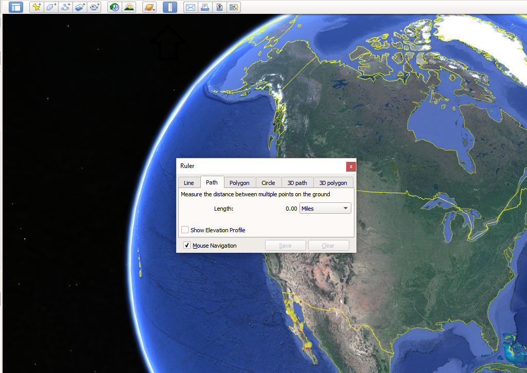
It's super easy in GE. Click the ruler icon at the top. And in the popup dialog, select Path. Connect the dots. The more points you add the more
exact it follows a path.
Then you can change the color or thickness of the track by right clicking it and editing the Properties.
Export it as a kml to BCN or Gaia.
[Edited on 1-31-2019 by JZ]
|
|
|
JZ
Elite Nomad
Posts: 9269
Registered: 10-3-2003
Member Is Offline
|
|
| Quote: Originally posted by mcnut | As long as the path is a mapped road there are other ways.
You can use software (Garmin BaseCamp and many others) the calculates a route using autorouting maps (such as Garmin or OpenSource maps). Save the
route as a track and export as a .kml file and open in GE.
If not mapped on autorouting maps then yes it becomes a manual but doable process in GE.
Bruce |
GE is far superior to BaseCamp. Not a fan of Garmin products at all. Very un-user friendly.
|
|
|
StuckSucks
Super Nomad
Posts: 2307
Registered: 10-17-2013
Member Is Offline
|
|
I use Google My Maps to create maps for the truck GPS and Gaia. If you trace a road as "driving directions," the line will auto-follow the road --
define a starting and ending location and the line will magically appear. With some post-noodling, you can eliminate the "directions" part of the
line, leaving a clean line along a road. As with other programs you can define the line's color and stroke.
|
|
|
David K
Honored Nomad
Posts: 64492
Registered: 8-30-2002
Location: San Diego County
Member Is Offline
Mood: Have Baja Fever
|
|
As JZ says, change the GE measuring ruler from Line to Path. It is a great tool.
|
|
|
Alm
Ultra Nomad
Posts: 2716
Registered: 5-10-2011
Member Is Offline
|
|
There is no easy way to do this in GE. You can manually make "path", a tedious work when the path is long.
OTH, Google Maps can do this automatically. But it won't always follow the particular road that you want, - instead it will take the shortest or the
fastest route, though you can drag/change this.
I'm curious - after all the stones throwing, how did we end up using Google ? 
|
|
|
okiegumbo
Junior Nomad
Posts: 32
Registered: 11-6-2005
Location: San Angelo, Texas
Member Is Offline
|
|
Thanks to All. I really appreciate your suggestions. I am working on a Baja trip for friends and was looking for a easy solution. I can't justify
spending $ for a one time use and I don't have the patience to learn new software (Ozzi,Gaia).
Too bad I live in Texas. I had much rather drive the route with my Lowrance Global 600. It would be a easy transfer to GE. I will just have to suck
it up and zoom in close with GE and use lots of dots.
Thanks Again
|
|
|
JZ
Elite Nomad
Posts: 9269
Registered: 10-3-2003
Member Is Offline
|
|
| Quote: Originally posted by Alm | There is no easy way to do this in GE. You can manually make "path", a tedious work when the path is long.
|
It's easy and fun to do it in Google Earth. Nothing tedious about it at all.
Sit down at your computer with a beer and you can pretty much map out the entire Seven Sisters in an hour or so.
You'll learn a place much better than someone hand spooning your a track.
[Edited on 1-31-2019 by JZ]
|
|
|
4x4abc
Ultra Nomad
Posts: 4168
Registered: 4-24-2009
Location: La Paz, BCS
Member Is Offline
Mood: happy - always
|
|
| Quote: Originally posted by okiegumbo | Thanks to All. I really appreciate your suggestions. I am working on a Baja trip for friends and was looking for a easy solution. I can't justify
spending $ for a one time use and I don't have the patience to learn new software (Ozzi,Gaia).
Too bad I live in Texas. I had much rather drive the route with my Lowrance Global 600. It would be a easy transfer to GE. I will just have to suck
it up and zoom in close with GE and use lots of dots.
Thanks Again |
What area are you looking at - i might have the racks
Harald Pietschmann
|
|
|
JZ
Elite Nomad
Posts: 9269
Registered: 10-3-2003
Member Is Offline
|
|
Throw your Lowrance in the garbage bin. Today's GPS apps on phones are 10x better.
|
|
|
okiegumbo
Junior Nomad
Posts: 32
Registered: 11-6-2005
Location: San Angelo, Texas
Member Is Offline
|
|
JZ Only way I would give up my Lowrance is ito pry it out of my dead hands.
It has traveled thousand and thousand of miles all over the USA with out fail. It shows hundreds and hundreds of two track trails in the west. It has
sat, images, turn by turn, FM broadcast, plays mp3 files and jpeg. 5.5 million points of info, trip planning, marine aids to navigation, odometer,
trip , stores,1000 tracts in different colors,odometer, tracks average speed, address searches, address book etc. etc.plus a 5 1/2 inch screen.
Calculates dtg, eta, voltage, altitude, blah blah. Junk? I think not! Oh, I forgot half dozen different languages too!
|
|
|
JZ
Elite Nomad
Posts: 9269
Registered: 10-3-2003
Member Is Offline
|
|
My phone does all that and much more. Plus has a much better screen, is brighter, and a way better UI.
UI on standalone GPS is complete trash. Once you step into the modern world you'll never go back.
|
|
|
TMW
Select Nomad
Posts: 10659
Registered: 9-1-2003
Location: Bakersfield, CA
Member Is Offline
|
|
Lowrance, OH, one of those guys.
|
|
|
StuckSucks
Super Nomad
Posts: 2307
Registered: 10-17-2013
Member Is Offline
|
|
How to draw a track along a road using Google Maps. Near the end of the video, I change the route demonstrating how that is done.
|
|
|
David K
Honored Nomad
Posts: 64492
Registered: 8-30-2002
Location: San Diego County
Member Is Offline
Mood: Have Baja Fever
|
|
Jim, when you clicked along the way, how did the line magically attach to the road? I only know the freehand ruler method. Thank you.
There is no sound, correct?
Edit: I use Google Earth and I just noticed your link is Google Maps... does it "see" roads and automatically put a distance line on them?
[Edited on 2-1-2019 by David K]
|
|
|
StuckSucks
Super Nomad
Posts: 2307
Registered: 10-17-2013
Member Is Offline
|
|
| Quote: Originally posted by David K | | I use Google Earth and I just noticed your link is Google Maps... does it "see" roads and automatically put a distance line on them?
|
Watch the beginning of the video again: I select a driving route (vs just a line) which automagically "sticks" to an existing road. Sometimes, the
road alignment which Google knows, can be different from reality -- they may be showing an old road grade. I'm using Google My Maps.
|
|
|
JZ
Elite Nomad
Posts: 9269
Registered: 10-3-2003
Member Is Offline
|
|
| Quote: Originally posted by StuckSucks | How to draw a track along a road using Google Maps. Near the end of the video, I change the route demonstrating how that is done.
|
Ha, ha, that's like cheating...
[Edited on 2-1-2019 by JZ]
|
|
|
| Pages:
1
2 |


