| Pages:
1
2 |
David K
Honored Nomad

Posts: 64476
Registered: 8-30-2002
Location: San Diego County
Member Is Offline
Mood: Have Baja Fever
|
|
Drive to BAHIA LAS ANIMAS (July, 2004)
0.0 L.A. Bay where one leaves the pavement heading south from the Xitlala (yellow) market intersection.
3.35 mi. Access road right to the Santa Marta mine tram line seen going up the mountain (next trip).
4.14 mi. Camp Gecko Driveway, office is 0.2 mi. left.
-----------------------------------------------------------------------------
0.0 Camp Gecko Driveway (28-53.96', 113-31.85' Map Datum is NAD27 Mexico)
5.7 Las Flores Jail to the west of road here
8.1 Road bends left, a 'Jeep' trail continues straight 3 miles to the end of the railroad line (terminal canyon) and bottom of the cable tram line
from the San Juan mines at the top of the mountains ( http://vivabaja.com/402/page4.html )
Yes Harald, that is a different mine and rail line... Your replying in the San Juan/Las Flores railroad thread without saying this was a different
place (Santa Marta) is what was confusing.
Thank you for KML links... The tracks from the Santa Marta Mine to the bay actually encircled the hill allowing gravity to take the full carts to the
bayshore and then the empty carts were returned, possibly using mules?
Isn't Baja great for discovering history?
|
|
|
4x4abc
Ultra Nomad
Posts: 4163
Registered: 4-24-2009
Location: La Paz, BCS
Member Is Offline
Mood: happy - always
|
|
Google even tells you the slope - 8.4%
vs Las Flores rail - 2.7%
since we have San Juan (Las Flores) and Santa Marta on the books now
what is the name of the mine directly above town?
28°56'33.55"N
113°34'59.75"W
there was a hike published here some time ago, but I could not find it
Harald Pietschmann
|
|
|
David K
Honored Nomad
Posts: 64476
Registered: 8-30-2002
Location: San Diego County
Member Is Offline
Mood: Have Baja Fever
|
|
When I am back home later, I will see what I have on the mines close to town.
EDIT: Still looking Harald, so far only find San Juan, Santa Marta, and El Toro.
The museum at Bahía de los Angeles might be the only good source for the other mine names? Carolina Espinoza runs it.
[Edited on 4-20-2019 by David K]
|
|
|
chuckie
Elite Nomad
Posts: 6082
Registered: 2-20-2012
Location: Kansas Prairies
Member Is Offline
Mood: Weary
|
|
OH-OH....DK got criticized!
|
|
|
larryC
Super Nomad
Posts: 1482
Registered: 8-11-2008
Location: BoLA
Member Is Offline
|
|
There are several mines in the vicinity, El Toro comes to mind right away. It is north of La Gringa and the shaft goes a long ways back in the
mountain. I have never been brave enough to find the end of it.
Off grid, 12-190 watt evergreen solar panels on solar trackers, 2-3648 stacked Outback inverters, 610ah LiFePo4 48v battery bank, FM 60 and MX60
Outback charge controllers, X-240 Outback transformer for 240v from inverters, 6500 watt Kubota diesel generator.
|
|
|
David K
Honored Nomad
Posts: 64476
Registered: 8-30-2002
Location: San Diego County
Member Is Offline
Mood: Have Baja Fever
|
|
Quote: Originally posted by larryC  | | There are several mines in the vicinity, El Toro comes to mind right away. It is north of La Gringa and the shaft goes a long ways back in the
mountain. I have never been brave enough to find the end of it. |
That sounds cool, Larry!
Where is the shaft?
I have only seen the open cut where the road ends and know of the village location to the east... I hiked part-way but lost the trail when I didn't
know the location exactly.

The end of the road at the El Toro Copper Mine.
Located about 7 miles northwest of La Gringa (north end of Bahia de los Angeles),
GPS: N29°05.86' W113°35.78' (NAD27 Mexico).
**** N29º05.87’ W113º35.82’ (WGS84)
My article on El Toro and La Gringa:
https://www.bajabound.com/bajaadventures/bajatravel/la_gring...
|
|
|
larryC
Super Nomad
Posts: 1482
Registered: 8-11-2008
Location: BoLA
Member Is Offline
|
|
Your photo of the cut is where you would park your vehicle and start walking in a southerly direction (following a trail) about a mile or so and then
you would see the tailings of the mine and some remnants of rock structures. That is where the shaft is. At the entrance to the mine the walls are
covered in green crystals, really pretty. The road up to the cut where your photo was taken is now washed out so you have to park a little farther
away from the trailhead to the mine. Once in the mine and back in a few hundred yards you go under some timbers wedged in to hold up the roof of the
mine and just knowing that the timbers are a hundred years old or so makes me wonder how smart it is to be bumbling around in there.
Off grid, 12-190 watt evergreen solar panels on solar trackers, 2-3648 stacked Outback inverters, 610ah LiFePo4 48v battery bank, FM 60 and MX60
Outback charge controllers, X-240 Outback transformer for 240v from inverters, 6500 watt Kubota diesel generator.
|
|
|
David K
Honored Nomad
Posts: 64476
Registered: 8-30-2002
Location: San Diego County
Member Is Offline
Mood: Have Baja Fever
|
|
| Quote: Originally posted by larryC | | Your photo of the cut is where you would park your vehicle and start walking in a southerly direction (following a trail) about a mile or so and then
you would see the tailings of the mine and some remnants of rock structures. That is where the shaft is. At the entrance to the mine the walls are
covered in green crystals, really pretty. The road up to the cut where your photo was taken is now washed out so you have to park a little farther
away from the trailhead to the mine. Once in the mine and back in a few hundred yards you go under some timbers wedged in to hold up the roof of the
mine and just knowing that the timbers are a hundred years old or so makes me wonder how smart it is to be bumbling around in there.
|
Oh, this is great. Do you mean somewhere else besides along the road, as it comes in from the south? I hiked the trail from about where the road ended
east, that goes to where the town was. When the trail vanished up on a mesa, I did not know where to go from there. Since then, I have found the
townsite on Google Earth and see that the trail went on to the east from the mesa. I heard before my 2107 trip to La Gringa that the El Toro mine road
was washed away.
Thanks Larry... Any photos??
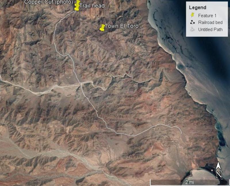
La Gringa and the road to El Toro mines
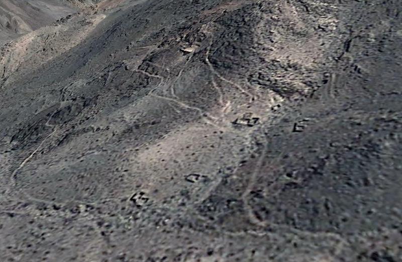
The townsite
[Edited on 4-21-2019 by David K]
|
|
|
| Pages:
1
2 |


