| Pages:
1
2 |
4x4abc
Ultra Nomad

Posts: 4165
Registered: 4-24-2009
Location: La Paz, BCS
Member Is Offline
Mood: happy - always
|
|
Ranchos in Sierra San Francisco
does anyone have a map or documentation that shows all ranchos in Sierra San Francisco?
David?
Harald Pietschmann
|
|
|
David K
Honored Nomad
Posts: 64490
Registered: 8-30-2002
Location: San Diego County
Member Is Offline
Mood: Have Baja Fever
|
|
Sure... but do you mean all in the past or all currently?
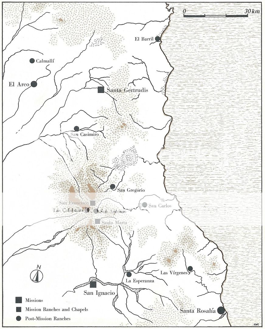
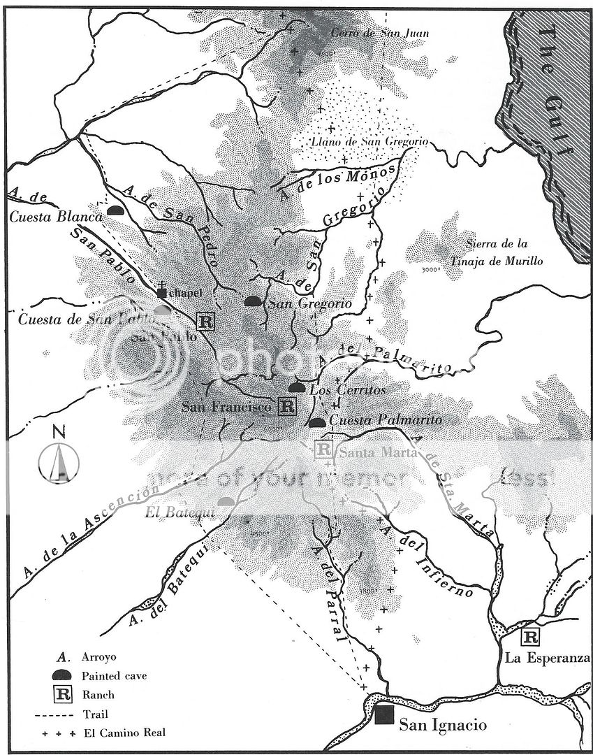
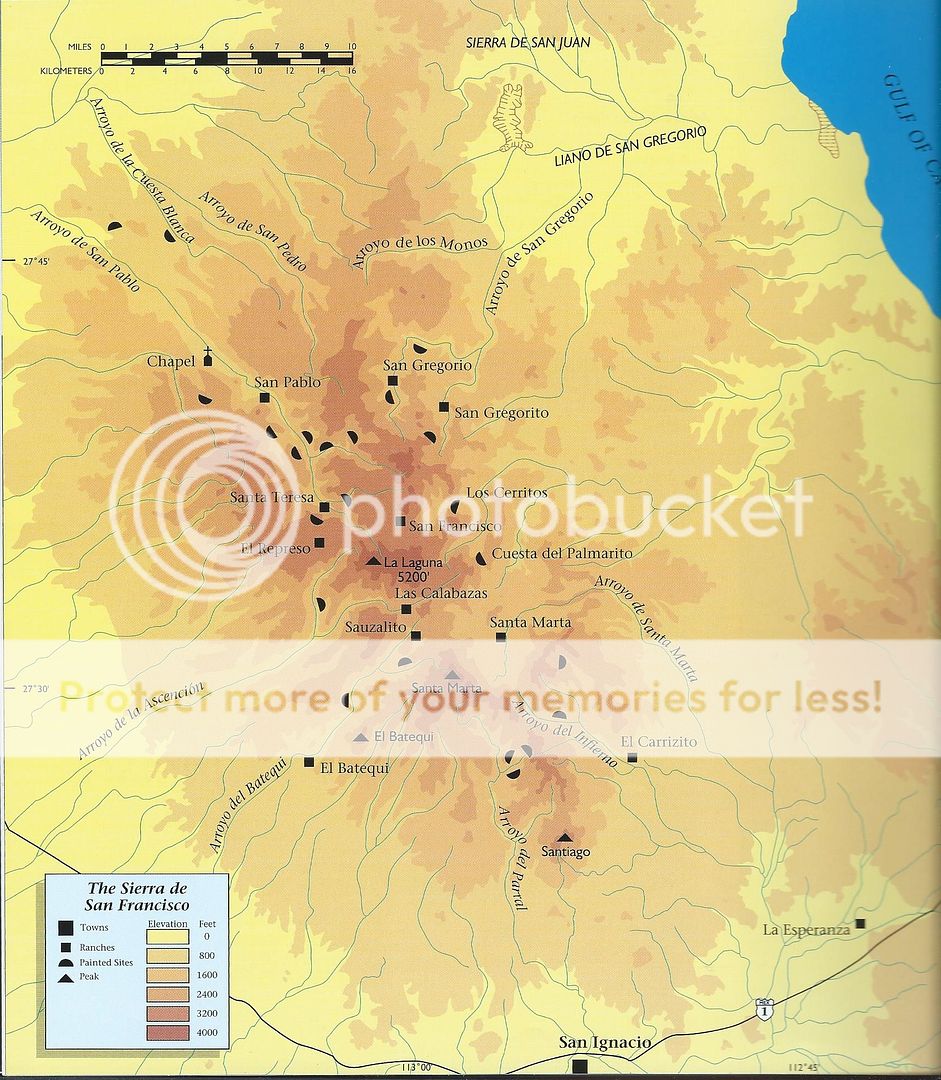
I have Harry Crosby's out of his book, Last of the Californios, c1981.
They include San Casimiro, San Gregorio, San Francisco, Las Calabazas, San Antonio, San Carlos, and Santa Marta.
In Harry's The Cave Paintings of Baja California, c1975, there also is Rancho San Pablo, plus in the newest edition, c1997: San Gregorito, Santa
Teresa, El Represo, and Sauzalito.
|
|
|
David K
Honored Nomad
Posts: 64490
Registered: 8-30-2002
Location: San Diego County
Member Is Offline
Mood: Have Baja Fever
|
|
1981 Last of the Californios
1975 Cave Paintings of Baja
1997 Cave Paintings of Baja
|
|
|
4x4abc
Ultra Nomad
Posts: 4165
Registered: 4-24-2009
Location: La Paz, BCS
Member Is Offline
Mood: happy - always
|
|
looking for info (map placement) of rancho San Pedro. Don't remember which map I got the name from.
Crosby has an Arroyo de San Pedro. The beginning of the waterway is where the rancho would be. Makes sense because arroyos get their name from local
ranchos and vice versa.
However, in newer maps Arroyo San Pedro has been renamed Arroyo El Tobardillo.
A smaller Arroyo San Pedro is now on Mesa Los Burros (away from rancho San Pedro)
and another small Arroyo San Pedro on Mesa San Pedro nearby
is it all just INEGI confusion?
a well defined trail runs to Visita San Pablo and to Rancho San Gregorio
27°40'50.54"N, 113° 3'26.70"W
Harald Pietschmann
|
|
|
David K
Honored Nomad
Posts: 64490
Registered: 8-30-2002
Location: San Diego County
Member Is Offline
Mood: Have Baja Fever
|
|
I have been saying (and showing) for years that INEGI maps are often mixed up. A government creation with no consequences for mistakes.
|
|
|
4x4abc
Ultra Nomad
Posts: 4165
Registered: 4-24-2009
Location: La Paz, BCS
Member Is Offline
Mood: happy - always
|
|
still looking for reference of the names
Harald Pietschmann
|
|
|
David K
Honored Nomad
Posts: 64490
Registered: 8-30-2002
Location: San Diego County
Member Is Offline
Mood: Have Baja Fever
|
|
Harald, I asked you a question and posted three maps with ranchos shown. Maybe you could do an overlap of Harry's maps and Inegi maps to compare?
|
|
|
4x4abc
Ultra Nomad
Posts: 4165
Registered: 4-24-2009
Location: La Paz, BCS
Member Is Offline
Mood: happy - always
|
|
the maps are too general - not much information
Harald Pietschmann
|
|
|
mtgoat666
Select Nomad
Posts: 17335
Registered: 9-16-2006
Location: San Diego
Member Is Offline
Mood: Hot n spicy
|
|
The number of ranches has decreased over the years. Hard times. People have moved away. Even before the decline, ranches came and went. The larger
or persistent ones probably made it onto various maps.
You won’t find one master map, you probably got to use several to find names.
[Edited on 6-25-2019 by mtgoat666]
Woke!
“...ask not what your country can do for you – ask what you can do for your country.” “My fellow citizens of the world: ask not what America
will do for you, but what together we can do for the freedom of man.”
Prefered gender pronoun: the royal we
|
|
|
4x4abc
Ultra Nomad
Posts: 4165
Registered: 4-24-2009
Location: La Paz, BCS
Member Is Offline
Mood: happy - always
|
|
I have been studying Baja for 30+ years
the number of ranches has increased
significantly
it is amazing where people try to scratch a living
interesting are the name changes
in the mission era ranchos had names of saints - San Pedro etc
starting with the early 1800's non saint names were favorites - Prosperidad etc
Harald Pietschmann
|
|
|
David K
Honored Nomad
Posts: 64490
Registered: 8-30-2002
Location: San Diego County
Member Is Offline
Mood: Have Baja Fever
|
|
Yes, ranches everywhere... but some of the older ones are gone. The kids don't want that life so they move to the city. A few do, and then there is
corporate money. Have you seen how old Rancho Arenoso has become a big modern farm (out from El Rosario)?
|
|
|
thebajarunner
Ultra Nomad
Posts: 3687
Registered: 9-8-2003
Location: Arizona....."Free at last from crumbling Cali
Member Is Offline
Mood: muy amable
|
|
Los Pinos follows the water
Quote: Originally posted by David K  | | Yes, ranches everywhere... but some of the older ones are gone. The kids don't want that life so they move to the city. A few do, and then there is
corporate money. Have you seen how old Rancho Arenoso has become a big modern farm (out from El Rosario)? |
That ranch had Pinos buses parked there last time we went by.
Those hombres are insatiable....
Find the water, crank out the Northbound goods.
As to the Sierra ranches
We were up there a couple years ago and they had let herds of goats run wild
It was pure desolation of the landscape for miles, those things will even eat rocks and fence posts.
|
|
|
BajaRat
Super Nomad
Posts: 1302
Registered: 3-2-2010
Location: SW Four Corners / Bahia Asuncion BCS
Member Is Offline
Mood: Ready for some salt water with my Tecate
|
|
Rancho Guadalupe is operational and not listed on either map ,
Just to the north of Rancho San Francisco.
Lionel 
[Edited on 7-3-2019 by BajaRat]
|
|
|
David K
Honored Nomad
Posts: 64490
Registered: 8-30-2002
Location: San Diego County
Member Is Offline
Mood: Have Baja Fever
|
|
INEGI

|
|
|
wilderone
Ultra Nomad
Posts: 3779
Registered: 2-9-2004
Member Is Offline
|
|
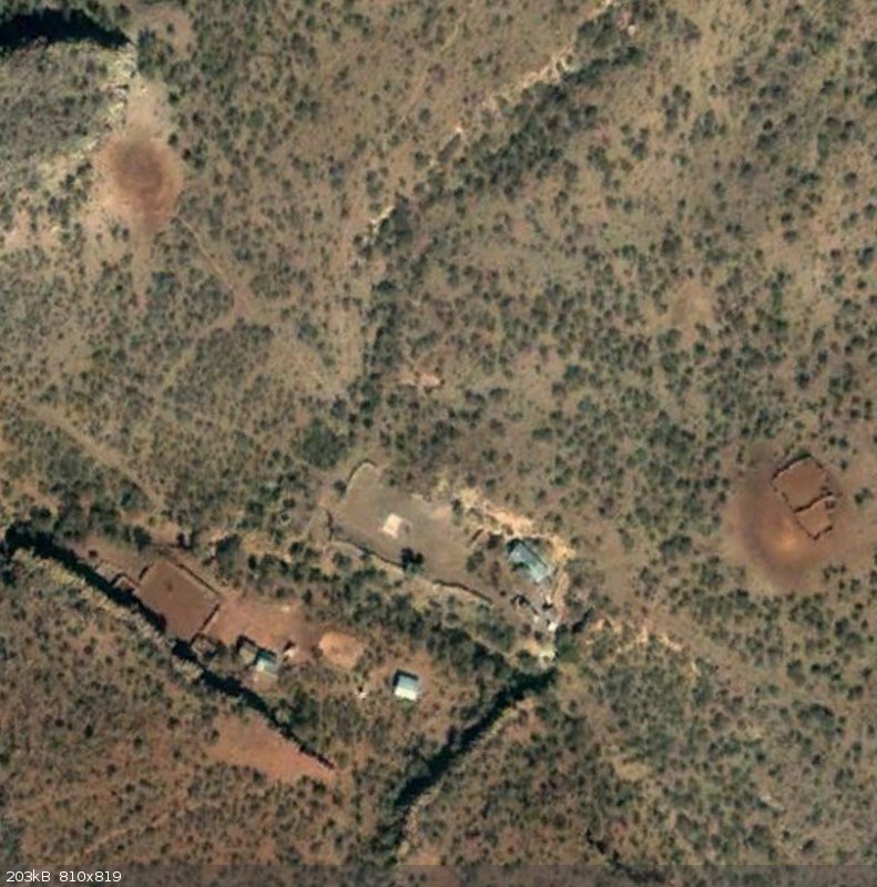
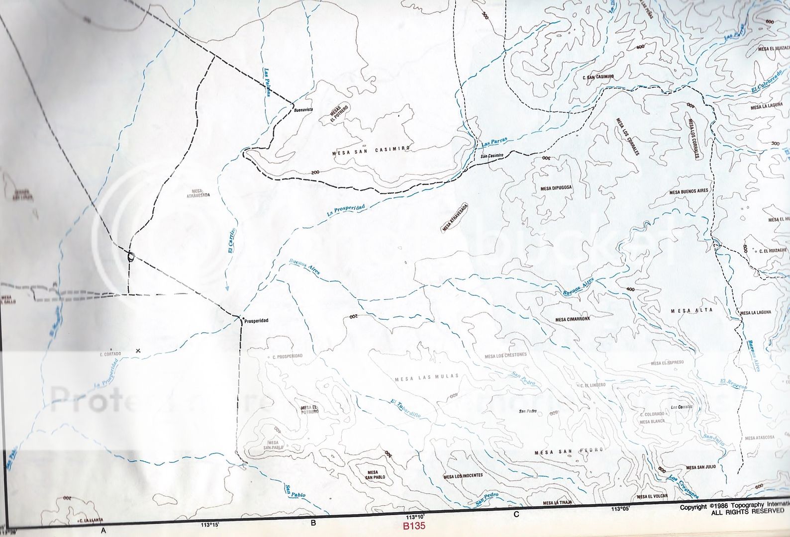
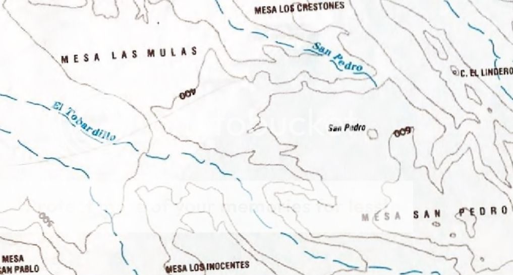
On the (old) big topo map book, San Pedro is denoted between Mesa San Pedro (So.) and rio or Arroyo San Pedro (No.) El Tobardillo is a different
rio/arroyo to the West of San Pedro. Mesa Las Mulas is slightly NE of El Tobardillo (and NW of San Pedro). San Pedro is about 7 mi. east of the end
of the Prosperidad road. Pg. B122, C3. About 113.7' x 27.46'. David K can blow it up for you. On that map, the names of the ranchos are not denoted
as "Rancho [ ]", but simply the name.
|
|
|
AKgringo
Elite Nomad
Posts: 5818
Registered: 9-20-2014
Location: Anchorage, AK (no mas!)
Member Is Offline
Mood: Retireded
|
|
David, what are the contour line intervals on the INEG map? It looks like 50 meters, but I have been confused before!
If you are not living on the edge, you are taking up too much space!
"Could do better if he tried!" Report card comments from most of my grade school teachers. Sadly, still true!
|
|
|
David K
Honored Nomad
Posts: 64490
Registered: 8-30-2002
Location: San Diego County
Member Is Offline
Mood: Have Baja Fever
|
|
| Quote: Originally posted by wilderone | | On the (old) big topo map book, San Pedro is denoted between Mesa San Pedro (So.) and rio or Arroyo San Pedro (No.) El Tobardillo is a different
rio/arroyo to the West of San Pedro. Mesa Las Mulas is slightly NE of El Tobardillo (and NW of San Pedro). San Pedro is about 7 mi. east of the end
of the Prosperidad road. Pg. B122, C3. About 113.7' x 27.46'. David K can blow it up for you. On that map, the names of the ranchos are not denoted
as "Rancho [ ]", but simply the name. |
Here is the area and followed by a close up over San Pedro from the Baja Topo Atlas:
|
|
|
David K
Honored Nomad
Posts: 64490
Registered: 8-30-2002
Location: San Diego County
Member Is Offline
Mood: Have Baja Fever
|
|
| Quote: Originally posted by AKgringo | | David, what are the contour line intervals on the INEG map? It looks like 50 meters, but I have been confused before! |
Good question! Without digging up that map off their website, let me just say I did take the elevation at San Francisco de la Sierra and it was 3,640'
or 1,109 meters. If they are at 50 meters, working up from the labeled 750-meter line, it looks like the circle for San Francisco is on the 950-meter
line. Maybe that is close enough to 1,100 on this map's scale?
|
|
|
4x4abc
Ultra Nomad
Posts: 4165
Registered: 4-24-2009
Location: La Paz, BCS
Member Is Offline
Mood: happy - always
|
|
INEGI contour lines are 20 meters on the 1:50,000 maps

Harald Pietschmann
|
|
|
mtgoat666
Select Nomad
Posts: 17335
Registered: 9-16-2006
Location: San Diego
Member Is Offline
Mood: Hot n spicy
|
|
| Quote: Originally posted by David K | | Quote: Originally posted by AKgringo | | David, what are the contour line intervals on the INEG map? It looks like 50 meters, but I have been confused before! |
Good question! Without digging up that map off their website, let me just say I did take the elevation at San Francisco de la Sierra and it was 3,640'
or 1,109 meters. If they are at 50 meters, working up from the labeled 750-meter line, it looks like the circle for San Francisco is on the 950-meter
line. Maybe that is close enough to 1,100 on this map's scale? |
That’s a pretty dopey answer for a map guy!
Woke!
“...ask not what your country can do for you – ask what you can do for your country.” “My fellow citizens of the world: ask not what America
will do for you, but what together we can do for the freedom of man.”
Prefered gender pronoun: the royal we
|
|
|
| Pages:
1
2 |


