| Pages:
1
2
3 |
motoged
Elite Nomad

Posts: 6481
Registered: 7-31-2006
Location: Kamloops, BC
Member Is Offline
Mood: Gettin' Better
|
|
I will ask the guy with it to give me a better link tomorrow....
Don't believe everything you think....
|
|
|
4x4abc
Ultra Nomad
Posts: 4163
Registered: 4-24-2009
Location: La Paz, BCS
Member Is Offline
Mood: happy - always
|
|
Quote: Originally posted by mtgoat666  |
Interesting us of the word “work.” I don't think jesuits did any work. I think the jesuit’s indigenous slaves did all of the work, and original
routes/paths were created by indigenous people long before jesuit imperialist missionaries arrived. |
with "work" I had the layout and detail in mind - not the actual work
agree with you on the slave part
Boleo wasn't any better
the laborers were pretty much owned by the company
Harald Pietschmann
|
|
|
David K
Honored Nomad
Posts: 64479
Registered: 8-30-2002
Location: San Diego County
Member Is Offline
Mood: Have Baja Fever
|
|
Arthur North expedition 1905-1906
| Quote: Originally posted by vacaenbaja | David, maybe you can help with this one. In Arthur North's book where he chronicles his near death experience walking through the Viscaino trying to
find the trail that led to San Ignacio it turns out that the natives said that he took the road least used.
That most people came into town using a different more traveled road. I think that he lost his bearings and never reached the more traveled junction.
Would you be able to trace out the route he took vs the route he should have? I remember as they struggled along he found the Camino Real trail by
its hallmarks of being out lined somewhat by stones and later on a number of lonely road side graves. |
Yes indeed!
I first read Camp & Camino when I was in Jr. college as they had it in their library. I have since read it again maybe twice. I have the original
1910 edition and the 1977 edition with a bunch of photos added by Dr. Michael Mathes.
Here is the map by North of the area:
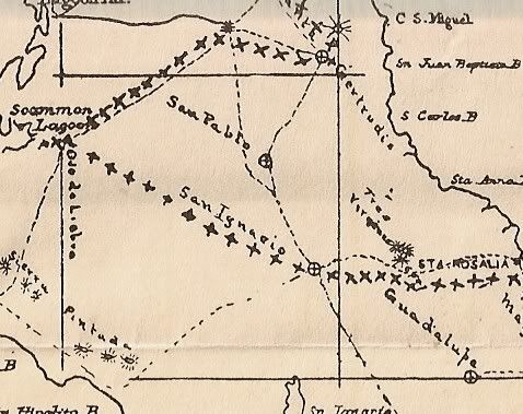
The dashed lines are trails and along the trail North rode are x's. From Santa Gertrudis he traveled to the gold mines of Calmalli and then to the
water hole of Ojo de Liebre (from which Mexican government mappers renamed Scammon's Lagoon). He shows San Pablo on the map along the Camino Real
(west or Pacifico branch) between Santa Gertrudis and San Ignacio.
Let me refresh my reading as to why he went to Ojo de Liebre and risked death for lack of water in doing so...
OK, I read the chapters from before getting to Santa Gertrudis, to Calmalli, to Ojo de Liebre, to San Angel, to San Ignacio, to Santa Rosalia.
The reason I couldn't remember why North didn't stick to El Camino Real south from Santa Gertrudis is that he doesn't say!
There is a mention of seeing his first Baja antelope (pronghorn) on the way to Ojo de Liebre, so perhaps that is why he crossed the Antelope Plain
(Vizcaino Desert) instead of sticking to the mountains with better water sources?
Oh, Harald, in 1906 the trail left San Ignacio going northeast then worked down to Santa Agueda before reaching Santa Rosalia.
|
|
|
4x4abc
Ultra Nomad
Posts: 4163
Registered: 4-24-2009
Location: La Paz, BCS
Member Is Offline
Mood: happy - always
|
|
| Quote: Originally posted by David K |
Oh, Harald, in 1906 the trail left San Ignacio going northeast then worked down to Santa Agueda before reaching Santa Rosalia.
|
I started this post by saying just that
Harald Pietschmann
|
|
|
David K
Honored Nomad
Posts: 64479
Registered: 8-30-2002
Location: San Diego County
Member Is Offline
Mood: Have Baja Fever
|
|
I didn't see a date at all in your post, and I just read it in North's book, so I thought I would let you know of that.
I am going to guess that in the 1930s, the Boleo Company blasted and bulldozed the grade used for the San Ignacio road because the Santa Agueda route
must have been more difficult to make for automobiles?
|
|
|
bajaric
Senior Nomad
Posts: 602
Registered: 2-2-2015
Member Is Offline
|
|
I think North was trying to intercept the trail shown as a dotted line on the map above between the Sierra Pintada and San Ignacio. This trail ran
west from San Angel through a pass in the Sierra Santa Clara and down to the coastline near Bahia San Hipolito. The trail no longer exists but in
1905 it was a well known route, used by hundreds of prospectors who had traveled up Harold's pre automobile trail from Santa Rosalia to San Ignacio
and then to San Angel. North missed the trail and ended up the Camino Real before he made it to San Ignacio, his guides shouting Agua! Agua!
|
|
|
bajaric
Senior Nomad
Posts: 602
Registered: 2-2-2015
Member Is Offline
|
|
[Edited on 7-14-2019 by bajaric]
|
|
|
4x4abc
Ultra Nomad
Posts: 4163
Registered: 4-24-2009
Location: La Paz, BCS
Member Is Offline
Mood: happy - always
|
|
| Quote: Originally posted by bajaric | | I think North was trying to intercept the trail shown as a dotted line on the map above between the Sierra Pintada and San Ignacio. This trail ran
west from San Angel through a pass in the Sierra Santa Clara and down to the coastline near Bahia San Hipolito. The trail no longer exists but in
1905 it was a well known route, used by hundreds of prospectors who had traveled up Harold's pre automobile trail from Santa Rosalia to San Ignacio
and then to San Angel. North missed the trail and ended up the Camino Real before he made it to San Ignacio, his guides shouting Agua! Agua!
|
Most of the trail between Ojo de Liebre and San Angel is still visible
Sierra Santa Clara has a cool network of trails that could have been used to reach Sierra La Pintada. Since there is very little local activity only
sections can be identified of sat images.
If you want to get lost forever - Vizcaino Desert would be perfect
Harald Pietschmann
|
|
|
4x4abc
Ultra Nomad
Posts: 4163
Registered: 4-24-2009
Location: La Paz, BCS
Member Is Offline
Mood: happy - always
|
|
forgot the track outline
Attachment: Ojo de Liebre - San Angel.kmz (1kB)
This file has been downloaded 177 times
Harald Pietschmann
|
|
|
bajaric
Senior Nomad
Posts: 602
Registered: 2-2-2015
Member Is Offline
|
|
I went back and Re-read North's account of crossing the desert and wanted to correct my above post and add a couple comments. The reason North
crossed the Vizcaino and almost died was because he wanted to shoot an antelope. He said he was on a trail used by the 49'rs that ran between the
water holes at San Angel and Ojo de Liebre. Going south, North strayed off that old trail, veered east of San Angel, and finally intersected the
trail between San Angel and San Ignacio where he saw the old graves and thought he was on the Camino Real.
If it seems incredible that he did it in 1905, think about doing it in 1849. It makes sense, in a way, as a short cut across the desert rather than
taking the old Mission route through the mountains. North said he thought that the 49'rs got off the boat at La Paz and walked up the length of Baja,
but that does not make any sense, why not get off the boat in San Francisco? More likely it was miners from Baja Sur who pulled up stakes and headed
for California who trod that desert path in 1849, like thousands of others who literally walked across the length of the United States to get to the
mother lode. But you know what they say about short cuts; the Donner party could tell you a few things about short cuts --
|
|
|
4x4abc
Ultra Nomad
Posts: 4163
Registered: 4-24-2009
Location: La Paz, BCS
Member Is Offline
Mood: happy - always
|
|
Rancho San Angel is hard to miss - even back then
unless you find a dry year with less water in Laguna San Ignacio and take route #6
there are no known trails between the west route from San Ignacio to Santa Gertrudis and San Angel
west of San Angel there are several choices - but that is not where he got lost
I am lost
Attachment: Lost.kmz (4kB)
This file has been downloaded 162 times

[Edited on 7-15-2019 by 4x4abc]
Harald Pietschmann
|
|
|
David K
Honored Nomad
Posts: 64479
Registered: 8-30-2002
Location: San Diego County
Member Is Offline
Mood: Have Baja Fever
|
|
What is the white line on the right representing, North's map of the approx ECR route? You know it goes in and out of the canyons and is far from
being that straight, yes?
Harry Crosby's 1977 edition ECR map:
My maps using the route data from www.caminorealbaja.com:
|
|
|
4x4abc
Ultra Nomad
Posts: 4163
Registered: 4-24-2009
Location: La Paz, BCS
Member Is Offline
Mood: happy - always
|
|
all lines represent established trails
they represent the concept, David, not the minute details of them
your maps are missing the west route from San Ignacio to Santa Rosalia (foothills of the mountains mostly)
Harald Pietschmann
|
|
|
4x4abc
Ultra Nomad
Posts: 4163
Registered: 4-24-2009
Location: La Paz, BCS
Member Is Offline
Mood: happy - always
|
|
here is what I have found so far
Attachment: west route.kmz (14kB)
This file has been downloaded 165 times
Harald Pietschmann
|
|
|
AKgringo
Elite Nomad
Posts: 5805
Registered: 9-20-2014
Location: Anchorage, AK (no mas!)
Member Is Offline
Mood: Retireded
|
|
Harald, whenever I try to view one of your KMZ files, all I get are lines of code!
What do I have to do to actually view the file? (keep it simple please)
Thanks!
If you are not living on the edge, you are taking up too much space!
"Could do better if he tried!" Report card comments from most of my grade school teachers. Sadly, still true!
|
|
|
4x4abc
Ultra Nomad
Posts: 4163
Registered: 4-24-2009
Location: La Paz, BCS
Member Is Offline
Mood: happy - always
|
|
revisiting the file I came upon some interesting human activities
Fields? Corral? Walls?
27°44'3.13"N, 113°11'9.71"W

Harald Pietschmann
|
|
|
David K
Honored Nomad
Posts: 64479
Registered: 8-30-2002
Location: San Diego County
Member Is Offline
Mood: Have Baja Fever
|
|
| Quote: Originally posted by 4x4abc | all lines represent established trails
they represent the concept, David, not the minute details of them
your maps are missing the west route from San Ignacio to Santa Rosalia (foothills of the mountains mostly) |
"My lines" are the actual El Camino Real as hiked by Genevieve Mattar and Kevin Branscum (and countless others the past 280 years. It also more
closely matches with Harry Crosby's map showing the three routes of El Camino Real north of San Ignacio. Do you have any documentation that your
'further west line' is connected to the mission period? Why would they be further down from the water sources and also not go through their visita of
San Pablo?
|
|
|
AKgringo
Elite Nomad
Posts: 5805
Registered: 9-20-2014
Location: Anchorage, AK (no mas!)
Member Is Offline
Mood: Retireded
|
|
| Quote: Originally posted by David K | | Quote: Originally posted by AKgringo | Harald, whenever I try to view one of your KMZ files, all I get are lines of code!
What do I have to do to actually view the file? (keep it simple please)
Thanks! |
Until Harald sees this, my response is to ask if you have Google Earth loaded because when I click on his file, my Google Earth map opens up and his
line is temporarily added in. |
Thanks David, I found the problem. Google Chrome is missing from my programs, so Google Earth will not function for me anymore. I am not sure why,
time to contact tech support (my son) to see what happened to it!
[Edited on 7-15-2019 by AKgringo]
If you are not living on the edge, you are taking up too much space!
"Could do better if he tried!" Report card comments from most of my grade school teachers. Sadly, still true!
|
|
|
4x4abc
Ultra Nomad
Posts: 4163
Registered: 4-24-2009
Location: La Paz, BCS
Member Is Offline
Mood: happy - always
|
|
Google Earth is a standalone program
Chrome is not needed
https://www.google.com/earth/versions/
Harald Pietschmann
|
|
|
4x4abc
Ultra Nomad
Posts: 4163
Registered: 4-24-2009
Location: La Paz, BCS
Member Is Offline
Mood: happy - always
|
|
| Quote: Originally posted by David K |
"My lines" are the actual El Camino Real as hiked by Genevieve Mattar and Kevin Branscum (and countless others the past 280 years. It also more
closely matches with Harry Crosby's map showing the three routes of El Camino Real north of San Ignacio. Do you have any documentation that your
'further west line' is connected to the mission period? Why would they be further down from the water sources and also not go through their visita of
San Pablo? |
Crosby did not have satellite images
I have recorded everything that is visible from the air - I did not rely on Crosby and others to tell me where to look
Is is mission period?
Don't know.
The same can be said about many trails supposedly Camino Real - are they?
I have some serious doubts after reading maps and sat images for 6 years
and no, I am not a scientist. I am a curious carpenter.
Harald Pietschmann
|
|
|
| Pages:
1
2
3 |


