| Pages:
1
2
3
4 |
del mar
Banned
Posts: 1057
Registered: 7-23-2016
Location: the cantina of course
Member Is Offline
Mood: lil' fuzzy
|
|
 ....yup might as well ....yup might as well
|
|
|
mtgoat666
Select Nomad

Posts: 17335
Registered: 9-16-2006
Location: San Diego
Member Is Offline
Mood: Hot n spicy
|
|
You can still use him for advice on posting pictures (remember the max width is 1200), and if you don’t feel like buying a map he does provide good
reproductions of those copyrighted maps you are too cheap to buy
Woke!
“...ask not what your country can do for you – ask what you can do for your country.” “My fellow citizens of the world: ask not what America
will do for you, but what together we can do for the freedom of man.”
Prefered gender pronoun: the royal we
|
|
|
JZ
Elite Nomad
Posts: 9262
Registered: 10-3-2003
Member Is Offline
|
|
Good thread guys.
|
|
|
David K
Honored Nomad
Posts: 64490
Registered: 8-30-2002
Location: San Diego County
Member Is Offline
Mood: Have Baja Fever
|
|
1955 AAA Map
Since the 1962 map brought so much fun to you guys, let's have a look at the 1955 AAA map. The is does not clearly differentiate between a paved road
and a dirt road. The 1951 guidebook has the road paved to Arroyo Grande ('oiled macadam', is how it is worded) which is just north of Colonet. That
was the end of pavement throughout the 1960s, as well. The San Felipe road is called "a good oil-mix surface" in 1951. No pavement until the town of
La Paz and then dirt again, on south. The 1959 guide says the paving reached 105 miles north from La Paz (about where it was in1966, too).
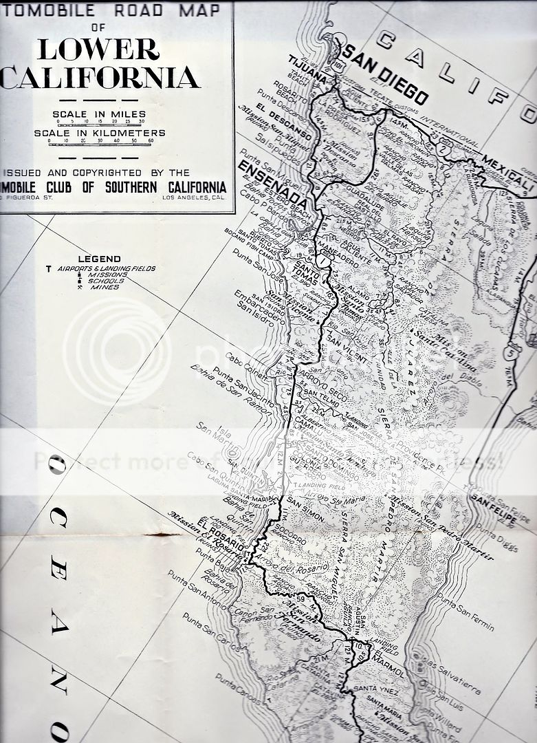
Despite the Mexico Federal Highway names, these were all dirt roads in 1955. The road south of La Paz was a single lane dirt track, grading began 10
years later.
|
|
|
4x4abc
Ultra Nomad
Posts: 4165
Registered: 4-24-2009
Location: La Paz, BCS
Member Is Offline
Mood: happy - always
|
|
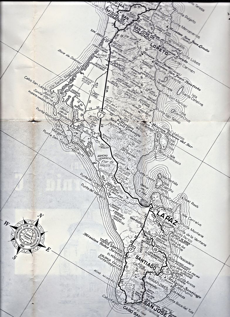
what is the lat long for Seal Rock north of Isla Cerralvo?
Harald Pietschmann
|
|
|
David K
Honored Nomad
Posts: 64490
Registered: 8-30-2002
Location: San Diego County
Member Is Offline
Mood: Have Baja Fever
|
|
This appears to be the correct spot, from https://mapcarta.com/20358174 :
Arrecife de la Foca
Type: reef
Location: Baja California Sur, Baja California, Mexico, North America
Latitude: 24° 26' (24.4333°) north
Longitude: 109° 59' (109.9833°) west
|
|
|
4x4abc
Ultra Nomad
Posts: 4165
Registered: 4-24-2009
Location: La Paz, BCS
Member Is Offline
Mood: happy - always
|
|
I have 3 different locations - confusing
Harald Pietschmann
|
|
|
David K
Honored Nomad
Posts: 64490
Registered: 8-30-2002
Location: San Diego County
Member Is Offline
Mood: Have Baja Fever
|
|
Well, what are they?
The Seal Rock is on all the AAA maps up to the 2010 one, and when I searched the same spot on the Internet, I found the link I shared.
|
|
|
4x4abc
Ultra Nomad
Posts: 4165
Registered: 4-24-2009
Location: La Paz, BCS
Member Is Offline
Mood: happy - always
|
|
there is this new community south of Vizcaino
does anyone have a name?
27° 35.525'N, 113° 21.573'W
Harald Pietschmann
|
|
|
Howard
Super Nomad
Posts: 2346
Registered: 11-13-2007
Location: Loreto/Manhattan Beach/Kona
Member Is Offline
Mood: I'd rather regret the things I've done than regret the things I haven't done.
|
|
Between the 2 of you the posting account for over 45 of the replies.
You have quite a bromance going. I think you guys should give each other a secret coded spot and meet for tea.
We don't stop playing because we grow old;
we grow old because we stop playing
George Bernard Shaw
|
|
|
4x4abc
Ultra Nomad
Posts: 4165
Registered: 4-24-2009
Location: La Paz, BCS
Member Is Offline
Mood: happy - always
|
|
nothing on the map
new community sprung up around 2000
Harald Pietschmann
|
|
|
4x4abc
Ultra Nomad
Posts: 4165
Registered: 4-24-2009
Location: La Paz, BCS
Member Is Offline
Mood: happy - always
|
|
Islote de la Reina (Arrecife de la Foca) Seal Rock
has no precise GPS location
Latitude: 24° 26' (24.4333°) north
Longitude: 109° 59' (109.9833°) west
is not precise
all others have resorted to distances given from the most northern point of Isla Cerralvo
4.25 nm, 4 miles and 6.43 km
the coordinates given are 4.57 nm out
I trust 6.43 km the most as it is part of a master thesis at CIB
https://cibnor.repositorioinstitucional.mx/jspui/bitstream/1...
this video shows a ship wreck at the site (6:24)
https://www.youtube.com/watch?v=zFOGIu4TX-4

Harald Pietschmann
|
|
|
BigBearRider
Super Nomad
Posts: 1299
Registered: 4-30-2015
Location: Big Bear, Punta Chivato, and Cabo
Member Is Offline
Mood: 
|
|
There are some ruins of something around San Marcos Tierra, northeast of Palo Verde. I recall seeing what I think were ovens, and a water system.
Maybe this was Las Delicias?
Also, I understand that Palo Verde, or maybe it was called then San Marcos, moved to its current location many, many years ago. It used to be about
halfway to Punta Chivato from where the highway is now. Maybe 40 or 50 years ago? There are still ruins of the old buildings, including the school,
in the old location. Some of the locals lived there.
As to Palm Trees and photos, no reasonable person can draw any real conclusions from such without knowing when the photos were taken relative to the
tide. I propose that science deniers be denied access to science generally, including medical science.
[Edited on 7-29-2019 by BigBearRider]
|
|
|
David K
Honored Nomad
Posts: 64490
Registered: 8-30-2002
Location: San Diego County
Member Is Offline
Mood: Have Baja Fever
|
|
Interesting... although no maps from back then show any town midway to Punta Chivato. I hope Harald scouts it out.
As for the palm beach; even if no palm was there, the sea has failed to rise higher. Otherwise, that flat area next to the beach would be underwater.
The palm is at the top of the beach and high tide has remained below it, since the 1930s. The same is true of all the salt flats... When sea levels do
rise any serious amount, they will be underwater, too!
|
|
|
BigBearRider
Super Nomad
Posts: 1299
Registered: 4-30-2015
Location: Big Bear, Punta Chivato, and Cabo
Member Is Offline
Mood:
|
|
Quote: Originally posted by David K  | Interesting... although no maps from back then show any town midway to Punta Chivato. I hope Harald scouts it out.
As for the palm beach; even if no palm was there, the sea has failed to rise higher. Otherwise, that flat area next to the beach would be underwater.
The palm is at the top of the beach and high tide has remained below it, since the 1930s. The same is true of all the salt flats... When sea levels do
rise any serious amount, they will be underwater, too! |
Seriously? You believe that a photo taken st an unknown time many years ago somehow disproves climate change? The sand on the beach in front of my
house moves all the time. Sometimes there are many meters of sand between my palm trees and high tide (and more during low tide) and sometimes none
at all. This change (among other things) creates problems for some people whose houses are now in the federal zone, when they previously were not.
Your observation provides zero support for your argument. No health care for you!
|
|
|
David K
Honored Nomad
Posts: 64490
Registered: 8-30-2002
Location: San Diego County
Member Is Offline
Mood: Have Baja Fever
|
|
No, I don't think it is any more than the obvious. We are not discussing sand movement/ erosion. The palm clearly shows that is not happening at El
Coyote. We are discussing sea level. If the sea (at high tide or any tide) is no higher now than in 1930, at least more than the length of a cigarette
or two, then there is no crisis... even if man caused it.
|
|
|
4x4abc
Ultra Nomad
Posts: 4165
Registered: 4-24-2009
Location: La Paz, BCS
Member Is Offline
Mood: happy - always
|
|
didn't you insist on sticking to the 1962 & 1955 AAA BAJA MAP discussion?
How do the palm trees fit in - again?
Harald Pietschmann
|
|
|
bajabuddha
Banned
Posts: 4024
Registered: 4-12-2013
Location: Baja New Mexico
Member Is Offline
Mood: Always cranky unless medicated
|
|
"The trouble with the world is not that people know too little, but that they know so many things that ain't so."
.....Mark Twain.
I don't have a BUCKET LIST, but I do have a F***- IT LIST a mile long!
86 - 45*
|
|
|
4x4abc
Ultra Nomad
Posts: 4165
Registered: 4-24-2009
Location: La Paz, BCS
Member Is Offline
Mood: happy - always
|
|
| Quote: Originally posted by BigBearRider | There are some ruins of something around San Marcos Tierra, northeast of Palo Verde. I recall seeing what I think were ovens, and a water system.
Maybe this was Las Delicias?
Also, I understand that Palo Verde, or maybe it was called then San Marcos, moved to its current location many, many years ago. It used to be about
halfway to Punta Chivato from where the highway is now. Maybe 40 or 50 years ago? There are still ruins of the old buildings, including the school,
in the old location. Some of the locals lived there.
|
San Marcos Tierra, like many other developments in the area (San Bruno, San Rafale etc), was a Boleo project to produce food for their workers.
Created in the early 1900's.
With abundant water under ground, several more farming projects (Pozo Cien, Pozo Noventa y Dos, etc)sprung up with government support in the 1950's
Rancho Las Delicias was a small ranch next to the old road (close to the new paved road). It only made it onto the maps because they had water.
Palo Verde is a government sponsored settlement that came up in the early 1980's, initially named Ejido San Lucas.
Harald Pietschmann
|
|
|
David K
Honored Nomad
Posts: 64490
Registered: 8-30-2002
Location: San Diego County
Member Is Offline
Mood: Have Baja Fever
|
|
| Quote: Originally posted by 4x4abc | didn't you insist on sticking to the 1962 & 1955 AAA BAJA MAP discussion?
How do the palm trees fit in - again? |
Ask Big Bear Rider... he felt the need to bring that into this thread. He (like others who also believe in the predictions), mixed up sand erosion
with sea-level rise.
The sand can move without the ocean getting higher. Wind, waves, currents, tides, all move sand. Lots of homes at Bahia Santa Maria have been lost or
damaged because the sand moved away from the front of their homes... but the sea is not any higher than before.
Science is not about predicting the future, it is studying the evidence. Has any climate change/ sea level prediction made since Al Gore was made god
of Global Warming come true? They don't even call it global warming anymore...
|
|
|
| Pages:
1
2
3
4 |


