| Pages:
1
2
3 |
baja Steve
Nomad

Posts: 469
Registered: 8-31-2003
Location: Bend, or
Member Is Offline
|
|
Hy 5 and Cocos
Has anyone been southbound on Hy 5 From San Felipe to Hy 1 in the last couple of days.
Is it well marked in the new construction areas? Is Coco still in his old camp? If not how do you get to his new camp.
I will be heading down 5 on Thursday the 14th.
thanks
[Edited on 11-10-2019 by baja Steve]
|
|
|
David K
Honored Nomad
Posts: 64493
Registered: 8-30-2002
Location: San Diego County
Member Is Offline
Mood: Have Baja Fever
|
|
TMW and other Nomads were just there at Coco's a couple days ago. The satellite ping came from Coco's original location.
Tom (TW) will post a report when he is back north... not sure when however. This afternoon at 2 pm he was at the El Tomatal road checkpoint, returning
north from the Mulegé area.
|
|
|
David K
Honored Nomad
Posts: 64493
Registered: 8-30-2002
Location: San Diego County
Member Is Offline
Mood: Have Baja Fever
|
|
Surprise!
As I was typing the above reply, a new Spot ping came in from TW... He is on thy new highway, parallel to Coco's Corner... (the new Hwy. is not shown
on the Satellite map, but you see where the red dart is showing where Tom sent the signal from.
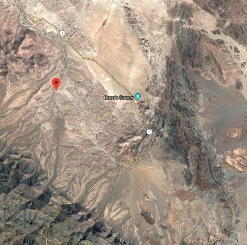
EDIT: Here is my GPS track on the new highway and detour on the south end, at about the same scale as the Spot map from TW:
[Edited on 11-10-2019 by David K]
|
|
|
PaulW
Ultra Nomad
Posts: 3009
Registered: 5-21-2013
Member Is Offline
|
|
New pavement just south of San Felipe make us happy. The gravel pit north of the curve is working full blast.
Here is what the wife said:
Starts at KM1
Some places gravel some with new blacktop on one side.
Some place both sides with new blacktop.
Some place are dug up with dirt or new gravel.
Had to drive in both the dirt and the gravel at some places.
Intermittent as far as KM34 which as far as she went.
The gravel and dirt sections appear to being rebuilt. as some were dug pretty deep.
Same narrow shoulders as before on the all new sections.
For sure, a work in progress.
A good thing because the road was really crappy.
|
|
|
PaulW
Ultra Nomad
Posts: 3009
Registered: 5-21-2013
Member Is Offline
|
|
David,
Could you could share your GPS track? The picture is not good enough.
|
|
|
David K
Honored Nomad
Posts: 64493
Registered: 8-30-2002
Location: San Diego County
Member Is Offline
Mood: Have Baja Fever
|
|
Paul, I just have the inReach map off the website. Is there some other way to show you the track?
|
|
|
JZ
Elite Nomad
Posts: 9269
Registered: 10-3-2003
Member Is Offline
|
|
Attach it here. GPX or KMZ.
|
|
|
4x4abc
Ultra Nomad
Posts: 4170
Registered: 4-24-2009
Location: La Paz, BCS
Member Is Offline
Mood: happy - always
|
|
yes, gpx or kmz please
Harald Pietschmann
|
|
|
PaulW
Ultra Nomad
Posts: 3009
Registered: 5-21-2013
Member Is Offline
|
|
==== =
Yes, Here are detailed instructions.
Go to your InReach account, select map. On the left pane select message types then select only “track points”. The in the same pane select Date
& Time range to find the track in question. Once you have that track displayed go to the upper right and select export then choose either KML or
GPX. The one you select will show up in Downloads for you to attach to your message.
Those of us that do this all the time have set our InReach device (Explorer) to give more than default. When choosing track points like every 2
seconds you will get a very large GPX that will be to big for and attachment on Nomads. In that case just choose KML which will fit fine and we all
can directly convert the KML to a GPS file like GPX, etc.
How to set up your Explorer InReach device to create more track points than the default:
Go to Settings, then Tracking, then choose Log Interval and then choose an appropriate log interval. For greatest detail choose 2 seconds for greatest
detail and a very large GPX file. For starters I suggest using 5 or 10 seconds. And depending on the length of the trip you may get a reasonable size
GPX file. When done go to tracking and verify you have chosen your log interval.
And when traveling and making an InReach track with great detailed log interval - be sure you have the device powered because it uses more battery
with more detail.
Review for persons new to InReach:
The device like Explorer/+ record track points whenever it is turned on. To transfer the track points to the Garmin server you do a Sync. Once the
track points are on the server then all the instructions above become available. Be sure to empty the memory in the device after Sync to get a fresh
- zero content memory. If you day multi day trip then all the tracks you make will all be loaded onto the server at once until you get to the Internet
for a Sync. And of course your device will fill up pretty fast if you have chosen high detail track log. It is important to turn off the device when
not needed to make tracks to save memory on the device for the multi day trip. Once the GPX file is created via the Export feature there are free
tools on the web that allow you to break apart these combined tracks to allow individual days. The exercise will also work with the KML file one track
at a time as defined by when you power off each track during the multi day trip.
[Edited on 11-11-2019 by PaulW]
|
|
|
bkbend
Senior Nomad
Posts: 693
Registered: 11-27-2003
Location: central OR or central baja
Member Is Offline
|
|
Steve, I was through there southbound in the middle of October and came back at the end of the month. There is (was) a large sign marking where you
can turn of to Coco's. The new road is now paved through that area, and the turn is more or less where you crest the rise entering the valley he sits
in. He's getting lonely, says only one or two travelers a day stop by now. I was there for about 90 minutes and he didn't stop talking.
The detours in the new construction south of Gonzaga are well marked, really only one detour and if you get off to go to Coco's you'll just follow the
old route until you hit pavement again.
There was also new, drivable pavement on reconstruction north of Puertocitos cutting the gravel there in half.
[Edited on 11-11-2019 by bkbend]
|
|
|
David K
Honored Nomad
Posts: 64493
Registered: 8-30-2002
Location: San Diego County
Member Is Offline
Mood: Have Baja Fever
|
|
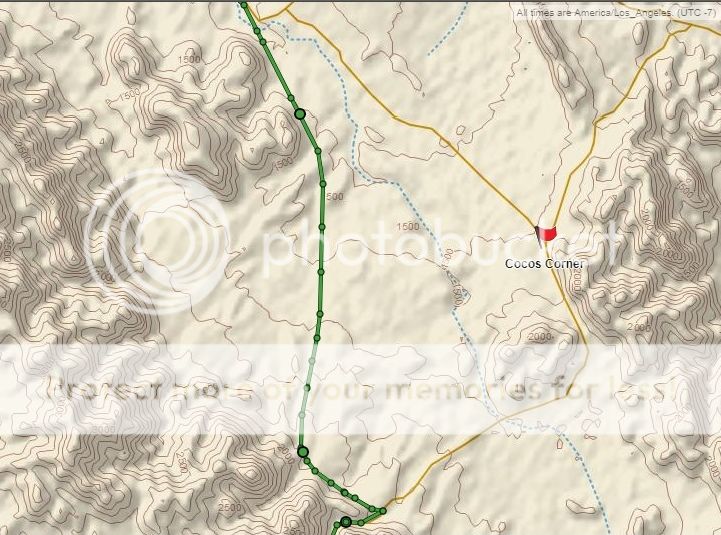
OK Paul, thanks for the step by step instructions. So, here is the KML file it made for when I last went south (May 13, 2019) with the Trail of
Mission Recon team for one hour (9-10 am) Gonzaga Bay to Laguna Chapala areas.
Ooops, well the KML file is well over the Nomad size limit for file uploads.
Is there another way to post a KML file here?
When I try to upload a GPX file, I get an Adobe popup announcing it is unsupported or the file has been damaged.
Here is the map from this morning's work zoomed in on Coco's bypass:
|
|
|
David K
Honored Nomad
Posts: 64493
Registered: 8-30-2002
Location: San Diego County
Member Is Offline
Mood: Have Baja Fever
|
|
When I click the Export on the Garmin page, my options are KML or GPX. How do I create a KMZ file?
|
|
|
StuckSucks
Super Nomad
Posts: 2307
Registered: 10-17-2013
Member Is Offline
|
|
If you upload the KML that is fine. The KMZ is just a compressed version. Either work. Same same (both are Keyhole Markup Language). Thanks!
[Edited on 11-11-2019 by StuckSucks]
|
|
|
JZ
Elite Nomad
Posts: 9269
Registered: 10-3-2003
Member Is Offline
|
|
A really easy way to make it smaller would be to:
Pull it into Google Earth. Trace a path over it. Save and upload that new path.
|
|
|
David K
Honored Nomad
Posts: 64493
Registered: 8-30-2002
Location: San Diego County
Member Is Offline
Mood: Have Baja Fever
|
|
Quote: Originally posted by StuckSucks  |
If you upload the KML that is fine. The KMZ is just a compressed version. Either work. Same same (both are Keyhole Markup Language). Thanks!
[Edited on 11-11-2019 by StuckSucks] |
If you can share with me the steps on how to convert the KML to a KMZ then I could post that on Nomad. Thank you for the help!
|
|
|
JZ
Elite Nomad
Posts: 9269
Registered: 10-3-2003
Member Is Offline
|
|
Email me the file at mz2442@gmail.com. I'll post it for you.
|
|
|
KasloKid
Nomad
Posts: 326
Registered: 8-29-2009
Member Is Offline
|
|
One can always use gps visualizer to convert files to your requirements. It's an online tool, and the download will be a bunch of strange numbers,
but you can change the name of the file to whatever you need. I use this all the time, in fact, if I try to open a file and get a corrupt message,
I'll run it through gpsvisualizer and the end result is a useable file.
Link:
https://www.gpsvisualizer.com/
|
|
|
PaulW
Ultra Nomad
Posts: 3009
Registered: 5-21-2013
Member Is Offline
|
|
KML to KMZ
Open the KML in Google earth
Hover your mouse over the track and right click then choose "save place as" and save file in KMZ format.
If the file is still too big try deleting a portion.
Or like was said above copy the GE trackimsom make a path.
|
|
|
PaulW
Ultra Nomad
Posts: 3009
Registered: 5-21-2013
Member Is Offline
|
|
I think you posted a image of part of your track? correct? The area if interest is probably just a small portion of your whole track? What I do with a
whole day of a track is load the track either KML or GPX and chop off the track points before and after the track part of interest. Then save it as a
KML. The free tool I use is "Trackmaker". Easy to use and has never failed me. Trackmaker is the easiest tool I have found to display on my PC and
still allow editing.
For example here is my Agua Caliente portion of a whole day of driving using 2 second track log.
Attachment: Agua Caliente Inreach.gpx (61kB)
This file has been downloaded 171 times
Attachment: Agua Caliente Inreach.kml (31kB)
This file has been downloaded 188 times
==== === ==
| Quote: Originally posted by David K | OK Paul, thanks for the step by step instructions. So, here is the KML file it made for when I last went south (May 13, 2019) with the Trail of
Mission Recon team for one hour (9-10 am) Gonzaga Bay to Laguna Chapala areas.
Ooops, well the KML file is well over the Nomad size limit for file uploads.
Is there another way to post a KML file here?
When I try to upload a GPX file, I get an Adobe popup announcing it is unsupported or the file has been damaged.
Here is the map from this morning's work zoomed in on Coco's bypass:
--- ---
DK impage removed
[Edited on 11-11-2019 by PaulW] |
|
|
|
David K
Honored Nomad
Posts: 64493
Registered: 8-30-2002
Location: San Diego County
Member Is Offline
Mood: Have Baja Fever
|
|
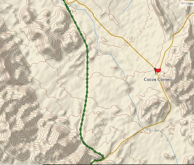
No, Paul, as I mentioned, that is just one hour of the day's track (Gonzaga to Chapala of the San Felipe to Mulegé day).
Thanks for the how-to. When I am back on the PC, I will try. Jim, if I have a problem, I will email you the KML.
Thanks, amigos!
|
|
|
| Pages:
1
2
3 |


