| Pages:
1
2
3 |
David K
Honored Nomad

Posts: 64547
Registered: 8-30-2002
Location: San Diego County
Member Is Offline
Mood: Have Baja Fever
|
|
Quote: Originally posted by PaulW  | KML to KMZ
Open the KML in Google earth
Hover your mouse over the track and right click then choose "save place as" and save file in KMZ format.
If the file is still too big try deleting a portion.
Or like was said above copy the GE trackimsom make a path. |
GREAT SUCCESS! Thank you, Paul...
Attachment: Coco Bypass.kmz (2kB)
This file has been downloaded 211 times
|
|
|
David K
Honored Nomad
Posts: 64547
Registered: 8-30-2002
Location: San Diego County
Member Is Offline
Mood: Have Baja Fever
|
|
| Quote: Originally posted by KasloKid | One can always use gps visualizer to convert files to your requirements. It's an online tool, and the download will be a bunch of strange numbers,
but you can change the name of the file to whatever you need. I use this all the time, in fact, if I try to open a file and get a corrupt message,
I'll run it through gpsvisualizer and the end result is a useable file.
Link:
https://www.gpsvisualizer.com/ |
What a fun page! I have seen it before but never spent much time on it.
Thank you...
Here is the elevation profile from Gonzaga Bay (near Rancho Grande store) to Hwy. 1 at Laguna Chapala:

|
|
|
PaulW
Ultra Nomad
Posts: 3021
Registered: 5-21-2013
Member Is Offline
|
|
David, What happened here:

|
|
|
PaulW
Ultra Nomad
Posts: 3021
Registered: 5-21-2013
Member Is Offline
|
|
| Quote: Originally posted by David K | I don't know what you are showing me?
The satellite image used by Google is old, does not show new highway construction.
OK, I see that is north of Las Arrastras... What is the question?
[Edited on 11-12-2019 by David K] |
=== == =
Zoomed way in when I was looking for side roads.
Just a joggle in the track, Did you backup for some reason?
|
|
|
David K
Honored Nomad
Posts: 64547
Registered: 8-30-2002
Location: San Diego County
Member Is Offline
Mood: Have Baja Fever
|
|
If this was my May 2019 track, I was a passenger in a Raptor driven by Curt LeDuc... along with other Raptors in Cameron's Trail of Missions Recon. I
do not recall that we ever stopped along here or backed up. I think we used the dirt detour as crews were active on the new pavement and it was
blocked off. In August of 2018 when I drove here, I was on the new paving as it was not blocked off fully.
|
|
|
4x4abc
Ultra Nomad
Posts: 4201
Registered: 4-24-2009
Location: La Paz, BCS
Member Is Offline
Mood: happy - always
|
|
why can't we get a kmz of TW's (accurate) track?
Harald Pietschmann
|
|
|
David K
Honored Nomad
Posts: 64547
Registered: 8-30-2002
Location: San Diego County
Member Is Offline
Mood: Have Baja Fever
|
|
TW's???
I posted my KMZ, did you see it?
Attachment: Coco Bypass.kmz (2kB)
This file has been downloaded 176 times
|
|
|
4x4abc
Ultra Nomad
Posts: 4201
Registered: 4-24-2009
Location: La Paz, BCS
Member Is Offline
Mood: happy - always
|
|
I see, Tom only has a SPOT
Harald Pietschmann
|
|
|
PaulW
Ultra Nomad
Posts: 3021
Registered: 5-21-2013
Member Is Offline
|
|
==== =
If he is using SPOT then he can export a GPX/KML file once he figures out how.
The problem with SPOT export file is you get the default track points with no ability to increase the points per unit time. The result is the low
quality track with a lot of straight lines that do not follow the curvy road. Like DK's KMZ
Tom usually carries a Garmin Nuvi, but in the past he only uses it to log waypoints.
John accompanying Tom and John use a real Lowrance so when he posts his files they will be dead on. John is very up to speed on all this stuff.
|
|
|
4x4abc
Ultra Nomad
Posts: 4201
Registered: 4-24-2009
Location: La Paz, BCS
Member Is Offline
Mood: happy - always
|
|
| Quote: Originally posted by PaulW |
==== =
If he is using SPOT then he can export a GPX/KML file once he figures out how.
The problem with SPOT export file is you get the default track points with no ability to increase the points per unit time. The result is the low
quality track with a lot of straight lines that do not follow the curvy road. Like DK's KMZ
Tom usually carries a Garmin Nuvi, but in the past he only uses it to log waypoints.
John accompanying Tom and John use a real Lowrance so when he posts his files they will be dead on. John is very up to speed on all this stuff.
|
so there is hope we'll see a good track
Harald Pietschmann
|
|
|
David K
Honored Nomad
Posts: 64547
Registered: 8-30-2002
Location: San Diego County
Member Is Offline
Mood: Have Baja Fever
|
|
TW posted on Facebook this:
Coco was in good spirits at the same location. We didn't stay too long, dropped off a few supplies and some small talk.
|
|
|
John M
Super Nomad
Posts: 1909
Registered: 9-3-2003
Location: California High Desert
Member Is Offline
|
|
David's In Reach track is right on the money
We came through there Monday afternoon and followed a route that seems to be exactly as the green track David posted.
I did make a track as we drove this bypass and will post info later today or tomorrow. Easy drive, only 3 or so miles of the old road bed.
Construction was in high gear through the remaining mountain cuts.
John M
|
|
|
David K
Honored Nomad
Posts: 64547
Registered: 8-30-2002
Location: San Diego County
Member Is Offline
Mood: Have Baja Fever
|
|
| Quote: Originally posted by John M | We came through there Monday afternoon and followed a route that seems to be exactly as the green track David posted.
I did make a track as we drove this bypass and will post info later today or tomorrow. Easy drive, only 3 or so miles of the old road bed.
Construction was in high gear through the remaining mountain cuts.
John M |
Thanks John, I will look forward to your Trip Report. I hope to see some kilometer marker notes too...?
|
|
|
bkbend
Senior Nomad
Posts: 693
Registered: 11-27-2003
Location: central OR or central baja
Member Is Offline
|
|
When I drove it last month I don't recall any KM markers along the newest pavement. It really isn't "finished" just paved.
|
|
|
David K
Honored Nomad
Posts: 64547
Registered: 8-30-2002
Location: San Diego County
Member Is Offline
Mood: Have Baja Fever
|
|
| Quote: Originally posted by bkbend | | When I drove it last month I don't recall any KM markers along the newest pavement. It really isn't "finished" just paved. |
Thanks...
I am also seeking the markers that were installed south from L.A. Bay. There were none when I logged the road in 2017. I would like to confirm if Km.
0 is where the dirt road begins (by Xitlali Market/ Tire shop corner). Then I could add the equivalent kilometer point to my mile point. However, it
would be best to note where they actually put the markers in relation to the points in my log: Camp Gecko, south bay road, Las Flores jailhouse road,
Terminal Canyon road, Green Door (old) road, Las Animas Road, Pancho's San Rafael road, south end of Green Door road, Jcn. with old El Arco road, New
El Arco road.
|
|
|
John M
Super Nomad
Posts: 1909
Registered: 9-3-2003
Location: California High Desert
Member Is Offline
|
|
Signs on the "New Road"
Westbound from Gonzaga, at Km 179 are these signs - turning left here takes you back on the nicely graded "old road" about five miles to Coco's. This
is about at Las Arrastras.
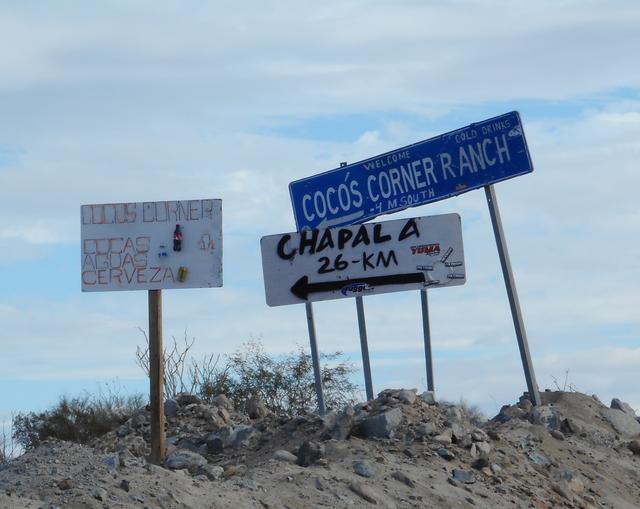 image sharing image sharing
If you were to take the above turn to Coco's, and wanted to continue west to Chapala then you would need to get back on the "old road" (slow/a little
rocky) for several miles before getting back onto the new roadbed.
Coming from the west, you are on a short detour when you see these signs. Straight for Coco's and left to get back onto the new roadbed.
v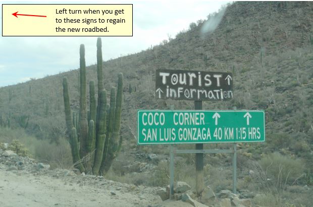
John M
[Edited on 11-13-2019 by John M]
|
|
|
David K
Honored Nomad
Posts: 64547
Registered: 8-30-2002
Location: San Diego County
Member Is Offline
Mood: Have Baja Fever
|
|
Good job, John!
|
|
|
PaulW
Ultra Nomad
Posts: 3021
Registered: 5-21-2013
Member Is Offline
|
|
Bypass track
I have deciphered a corrupted track that John made with his GPS
GPS GPX track s attached
Here is an image

Attachment: PW coco+Bypass.gpx (17kB)
This file has been downloaded 148 times
Attachment: PW coco+Bypass1.kml (8kB)
This file has been downloaded 159 times
|
|
|
David K
Honored Nomad
Posts: 64547
Registered: 8-30-2002
Location: San Diego County
Member Is Offline
Mood: Have Baja Fever
|
|
Checking over my notes, if they have a Km. 179 post at the branch to Coco's (the former route south), it might be 3 kms. too many, like the signs near
the older detour/ end of pavement were briefly before being changed a few years ago. It was Km. 170 and Gonzaga Pemex was 150. They changed the Pemex
marker to 147 and the last one to 167.
In August 2018, the last marker, at Chapala, was Km. 200, which I also estimated to be about 3 kms. too many. Might be a project to check out? The
ArcGIS satellite map is newer than Google Earth and the new route can be traced with a measurement track.
The old end of pavement detour was at Km. 167.5 (formerly 170.5).
The old road/ route to Coco's heading south is 8.5 kilometers away. That means the marker by it should be Km. 176. That John notes it is Km. 179 would
mean they are back at the 3 kms. too high numbers.
I can also measure that it is 3 kms. from the La Turquesa Canyon road to Coco's branch (old road), which would put it at Km. 176. Provided there is a
way to get from the new pavement onto it and no barb wire fence added.
|
|
|
PaulW
Ultra Nomad
Posts: 3021
Registered: 5-21-2013
Member Is Offline
|
|
Pretty easy to log the distance miles or kilometers for the GE file I posted. Of course the placement of the signs would not be coordinated very
close.
|
|
|
| Pages:
1
2
3 |


