| Pages:
1
2
3 |
David K
Honored Nomad

Posts: 64479
Registered: 8-30-2002
Location: San Diego County
Member Is Offline
Mood: Have Baja Fever
|
|
Yes, and I hope if I can't get down there that another Nomad will note the Kilometer marker location as related to roads and points of interest.
|
|
|
bajaric
Senior Nomad
Posts: 602
Registered: 2-2-2015
Member Is Offline
|
|
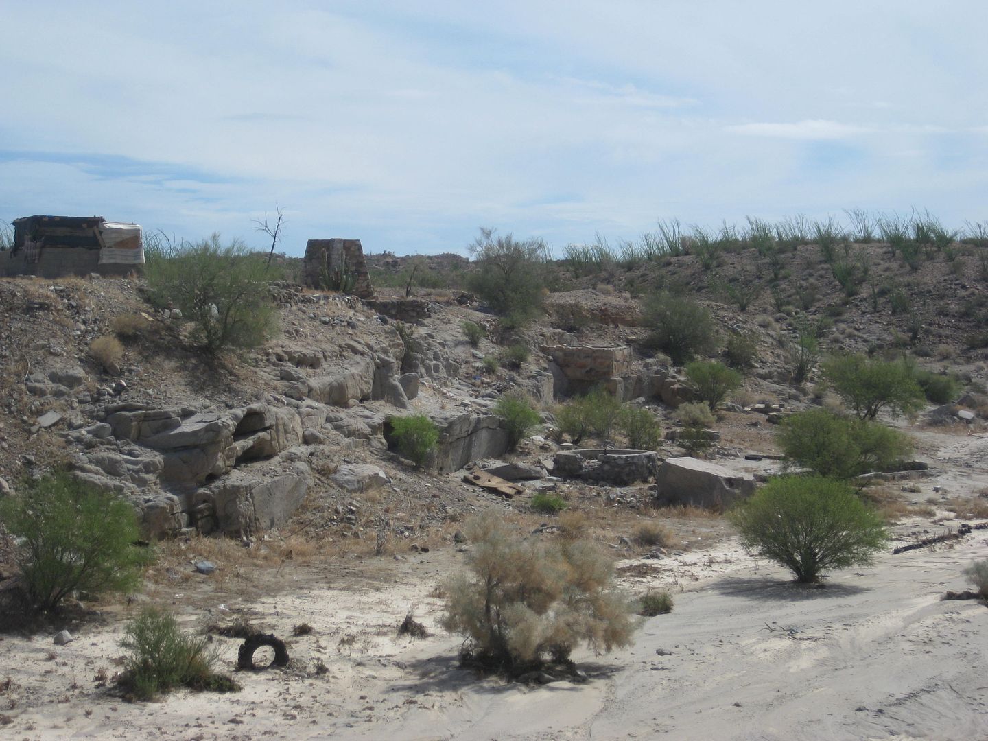
I just returned from driving part of the new paved "Cocos bypass" from north to south. On the BCA it shows a mine called Mala Chilangos. I had hoped
that the new paved bypass would intersect the road to this mine but I saw no sign of it. I got as far as
N29°29’31.4” W114°19’57.7”
which is where the picture was taken. It was neat to see this virgin country; no trash, no buildings, no people, nada, just a series of arroyos
running across the landscape, some elephant trees and boulders here and there, mostly volcanic rock at the surface. Kind of sad to see a strip of
blacktop laid down and the landscape all trashed but that is progress I guess. I would expect they are eventually going to put up a fence all along
here so get in there now and have a look around while you can. There are a few places to park off the pavement where they were digging up road base
material, left a mess as usual.
To summarize the road conditions from San Felipe south to Puertecitos, they have made a lot of progress. The detours are fewer in number and a lot of
new asphalt has been put down where the worst of the potholes used to be, although there are still a few dirt sections and small drop offs where the
road was washed out and a couple miles of dirt bypass road. All paved in front of Cow Patty now. From Puertecitos to Gonzaga more progress. There
were three long dirt detours where bridges had been washed out. The northern one, just south of Puertecitos and the far southern one, just north of
Huerfanito have been repaired to the point where you stay on the pavement, leaving only one major bridge washout in the middle with a steep dirt
section that might be a challenge for towing extra long trailers especially north bound. There are quite a few short detours but all in all much
better conditions than before, not going to be long before this road is all paved if they continue at this rate; they were laying down asphalt as I
drove past.
A couple of miles south of Las Arrastras (by the bridge with the yellow guard rails) there is a road and a hand made sign pointing to Cocos, (to the
left if you are going south).
Saw a few prerunners at km 94 on Hwy 5 north of San Felipe on Friday, turns out the race was postponed a day. Light rain in San Felipe, almost nil
south of Puertecitos just a mist.

[Edited on 11-23-2019 by bajaric]
|
|
|
David K
Honored Nomad
Posts: 64479
Registered: 8-30-2002
Location: San Diego County
Member Is Offline
Mood: Have Baja Fever
|
|
Any more photos, Ric?
The GPS you give is near the detour to the older road as you near the canyon area, where they are punching through the mountain, into the canyon.
The photo appears to be looking north?
No driving on the blacktop there?
|
|
|
bajaric
Senior Nomad
Posts: 602
Registered: 2-2-2015
Member Is Offline
|
|
DK, yes, that is very near where they are punching through the mountain. Picture is looking north. I was just parked on the side of the road, it is
drivable both directions and paved all the way to Gonzaga from there. Semis are using it now. Some pretty impressive bridges.
Sorry, no more photos. I always forget to still photos because I am usually shooting videos, then I wish I had taken more still photos. I have some
video but to post it here requires putting it on YouTube which is a pain because my super slow computer takes forever to convert files to be YouTube
format.
The one disappointment was I wanted to see the arrastra at Las Arrastras, and I could not find it. I checked your past post with a picture of it when
I got home and I think I was almost standing on top of it but it was hidden down in the arroyo. I was at at the bridge with the yellow guard rails
which is where the new paved road starts the Cocos bypass and splits off from the old dirt highway to Cocos. That is the second darn time I have
tried to find that thing and missed it! And it is a 600 mile round trip so not like I can just go back and check again.
[Edited on 11-23-2019 by bajaric]
|
|
|
David K
Honored Nomad
Posts: 64479
Registered: 8-30-2002
Location: San Diego County
Member Is Offline
Mood: Have Baja Fever
|
|
Quote: Originally posted by bajaric  | DK, yes, that is very near where they are punching through the mountain. Picture is looking north. I was just parked on the side of the road, all
drivable blacktop both directions, semis are using it now. Some pretty impressive bridges.
Sorry, no more photos. I always forget to still photos because I am usually shooting videos, then I wish I had taken more still photos. I have some
video but to post it here requires putting it on YouTube which is a pain because my super slow computer takes forever to convert files to be YouTube
format.
The one disappointment was I wanted to see the arrastra at Las Arrastras, and I could not find it. I checked your past post with a picture of it when
I got home and I think I was almost standing on top of it but it was hidden down in the arroyo. I was at at the bridge with the yellow guard rails
which is where the new paved road starts the Cocos bypass and splits off from the old dirt highway to Cocos. That is the second darn time I have
tried to find that thing and missed it! And it is a 600 mile round trip so not like I can just go back and check again. |
It would be the first bridge south of where the older road branched off (and now well-signed for Coco's Corner, per Nomad posts). It is very visible
from the bridge:
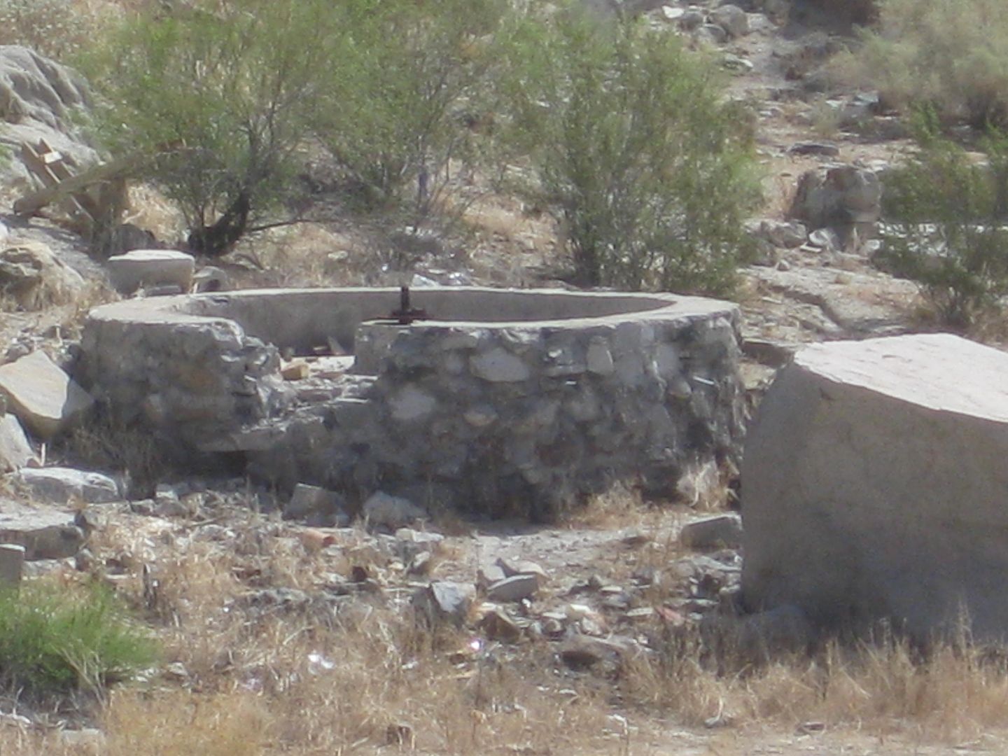
Las Arrastras de Arriola
|
|
|
ZipLine
Nomad
Posts: 109
Registered: 7-16-2015
Member Is Offline
|
|
I drove through there last week and no sign of Cocos - and I was looking as I wanted to meet/see the legend.
|
|
|
David K
Honored Nomad
Posts: 64479
Registered: 8-30-2002
Location: San Diego County
Member Is Offline
Mood: Have Baja Fever
|
|
| Quote: Originally posted by ZipLine | I drove through there last week and no sign of Cocos - and I was looking as I wanted to meet/see the legend.
|
What are you saying?
You were on the old road and Coco's Corner was gone or Coco wasn't home? OR, were you on the new, paved highway and didn't see the signs pointing out
where to turn off the highway to go to Coco's Corner?
|
|
|
John M
Super Nomad
Posts: 1906
Registered: 9-3-2003
Location: California High Desert
Member Is Offline
|
|
Maybe the signs to Coco's are down?
A week or so before you came through, if you were driving toward Gonzaga Bay from Chapala you should have seen this sign.
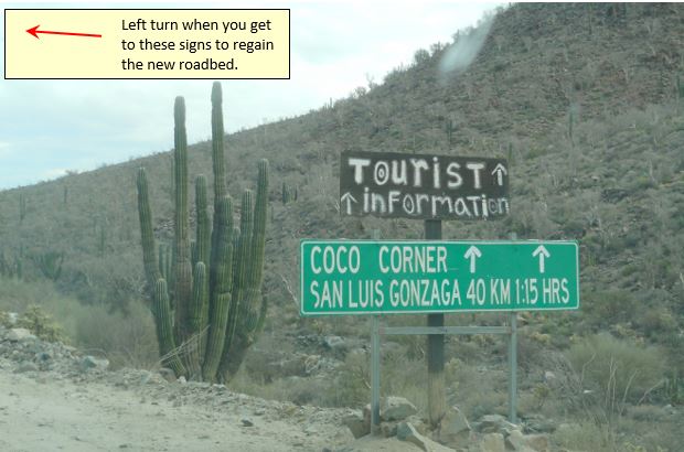
Going west from Gongzaga Bay toward Chapala and Highway 1 was this at Km 179

John M
|
|
|
David K
Honored Nomad
Posts: 64479
Registered: 8-30-2002
Location: San Diego County
Member Is Offline
Mood: Have Baja Fever
|
|
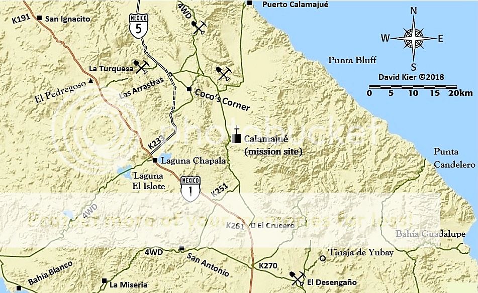
When John says "west from Gonzaga" you are southbound on Hwy. 5. The final few miles do curve towards the west where it meets Hwy. 1.
On this map, the pair of dashed lines is the new highway route where it bypasses Coco's Corner (which is on the old route). The map was made last year
before the new route was open to all traffic.
|
|
|
honda tom
Nomad
Posts: 493
Registered: 8-28-2003
Location: middle calif
Member Is Offline
|
|
stopped by on Tuesday and Coco is doing well. He said hes not moving up to the new road.... is staying put.
His honda quad is in need of new front tires. they are bald and no longer hold air.
Tire size 25x8x12 tubeless
|
|
|
NE14Baja
Junior Nomad
Posts: 56
Registered: 8-14-2008
Member Is Offline
|
|
Coco’s Corner
We stopped by to visit Coco on Nov 13. We were heading south from Gonzaga on the new road and saw the sign clearly marked to Coco’s, quick left turn
onto the old road and about four miles in you’re at Coco’s!!!
He looked great, was in good spirits and we had a great time visiting.
His young helper had just returned from putting up a new sign on the south side of the old road indicating the turn off for Coco’s.
It appears his plan for relocating is now scrapped. He said those that were supposed to assist with the move did not show cause they were to busy so
he’s decided to stay put.
We’ll continue to visit Coco and support him any way we can.
|
|
|
bajarich
Nomad
Posts: 463
Registered: 1-13-2005
Member Is Offline
|
|
| Quote: Originally posted by David K | | Quote: Originally posted by bajaric | DK, yes, that is very near where they are punching through the mountain. Picture is looking north. I was just parked on the side of the road, all
drivable blacktop both directions, semis are using it now. Some pretty impressive bridges.
Sorry, no more photos. I always forget to still photos because I am usually shooting videos, then I wish I had taken more still photos. I have some
video but to post it here requires putting it on YouTube which is a pain because my super slow computer takes forever to convert files to be YouTube
format.
The one disappointment was I wanted to see the arrastra at Las Arrastras, and I could not find it. I checked your past post with a picture of it when
I got home and I think I was almost standing on top of it but it was hidden down in the arroyo. I was at at the bridge with the yellow guard rails
which is where the new paved road starts the Cocos bypass and splits off from the old dirt highway to Cocos. That is the second darn time I have
tried to find that thing and missed it! And it is a 600 mile round trip so not like I can just go back and check again. |
It would be the first bridge south of where the older road branched off (and now well-signed for Coco's Corner, per Nomad posts). It is very visible
from the bridge:
Las Arrastras de Arriola |
What was it used for? All I could find is the verb Arrastrar.
|
|
|
David K
Honored Nomad
Posts: 64479
Registered: 8-30-2002
Location: San Diego County
Member Is Offline
Mood: Have Baja Fever
|
|
Grinding ore to extract gold. I think a mule was used to turn the mill (arrastra). Near Tinaja de Yubay is a small, hand arrastra.
|
|
|
David K
Honored Nomad
Posts: 64479
Registered: 8-30-2002
Location: San Diego County
Member Is Offline
Mood: Have Baja Fever
|
|
I wrote an article on Las Arrastras a few years ago... At the time I wasn't sure of how the new highway would cross over the site...
https://www.bajabound.com/bajaadventures/bajatravel/las_arra...
|
|
|
ed26
Newbie
Posts: 16
Registered: 10-14-2014
Member Is Offline
|
|
Quick update. Just got back. Clocked unpaved road from Gonzaga to Chapala now down to 2.5 miles. Made Pemex at Gonzaga to Pemex at Guerrero in just
about 2 hours. Not airing down and back up saves a ton of time 
Progress being made from San Felipe through Puertocitos as well. At the pace you'd expect, but there was even some progress in the 1 week turn around
from us going down and back. The bigger bridge is drivable, (but still getting worked on), and the other turn outs are down to only a half dozen or
so. Should be all done just in time for a good washout next year!
|
|
|
| Pages:
1
2
3 |


