| Pages:
1
2
3 |
pacsur
Nomad

Posts: 191
Registered: 8-28-2003
Location: San Jose del Cabo,BCS
Member Is Offline
|
|
Gaia Baja maps
I just received an email promo saying Gaia now has Baja and Baja Sur maps available for download included with premium service, has anybody seen them
yet?
New to me at least-
https://blog.gaiagps.com/new-baja-california-maps-from-natio...
[Edited on 5-6-2020 by pacsur]
|
|
|
JZ
Elite Nomad
Posts: 9269
Registered: 10-3-2003
Member Is Offline
|
|
Can you post the text of the email? Or a link?
Gaia has always had satellite and topo for Baja.
|
|
|
StuckSucks
Super Nomad
Posts: 2307
Registered: 10-17-2013
Member Is Offline
|
|
Looks interesting, I'll have to give it a go. Satellite images are the most helpful in my world -- in the past I have downloaded sat images of the
areas I was going to be in. But the NatGeo Baja topo maps may have value too.
|
|
|
white whale
Nomad
Posts: 157
Registered: 12-15-2015
Location: canada
Member Is Offline
|
|
what an awesome site ! thank you for posting - did not know at all about Gaia GPS. Gotta figure out the pronunciation.
First time I've seen USGS Topo layer tool . Slick!
Guy yah
[Edited on 5-6-2020 by white whale]
This ain't no party, this ain't no disco, this ain't no foolin' around Life During Wartime
- Talking Heads '79
|
|
|
David K
Honored Nomad
Posts: 64493
Registered: 8-30-2002
Location: San Diego County
Member Is Offline
Mood: Have Baja Fever
|
|
Don't forget geoffff's wonderful site with topo and satellite maps and combos that you can switch back and forth onto: https://caltopo.com/map.html#ll=27.60902,-112.90375&z=11...
(This is linked on my website, along with other zoom-able maps)
|
|
|
John M
Super Nomad
Posts: 1907
Registered: 9-3-2003
Location: California High Desert
Member Is Offline
|
|
GAIA
I believe Paul W has mentioned GAIA.
We used it in the East Mojave on a remote trip with success. We had the "free" version but the premium allows you to load tracks ahead of time from
what I understand.
Nice features, no internet required when you are using it.
Wish I had a tablet, the borrowed one that I used is now back to its owner.
John M
|
|
|
white whale
Nomad
Posts: 157
Registered: 12-15-2015
Location: canada
Member Is Offline
|
|
Cal Topo - wow x 2. They get fresher images. Local running track / sport field here just got a refurb to fake grass and a blue track - and there it
is! ........ and no one can use it .
Nice add David !
----------------------------------------------
This ain't no party, this ain't no disco, this ain't no foolin' around Life During Wartime
- Talking Heads '79
|
|
|
geoffff
Senior Nomad
Posts: 644
Registered: 1-15-2009
Member Is Offline
|
|
Well let's not call it "my" site  I contributed the INEGI Mexico topo maps - but
that's just one feature on a very extensive website. I contributed the INEGI Mexico topo maps - but
that's just one feature on a very extensive website.
Gaia GPS will also show these INEGI Mexican topo maps if you select "USGS Topo ©CalTopo" in the Layers menu. These maps will have a lot more detail
than the National Geographic layer pacsur mentioned.
BackCountry Navigator is another popular GPS/map app, but for some reason they still use an old copy of the CalTopo maps (before Mexico and Canada
were added). So, stick to Gaia GPS.
-- Geoff
|
|
|
David K
Honored Nomad
Posts: 64493
Registered: 8-30-2002
Location: San Diego County
Member Is Offline
Mood: Have Baja Fever
|
|
I meant that it was you who shared that site with us and I appreciate that you did!
|
|
|
PaulW
Ultra Nomad
Posts: 3009
Registered: 5-21-2013
Member Is Offline
|
|
The real question is the topo feature more important than detailed roads. Especially in the backcountry.
Of course I use both, but when heading out in the back country the roads are my choice. Both are nice, but not a necessity.
Of course if one chooses topo and the result is INEGI then what you get is pretty images, but no roads (or selected roads from the 1960s). The
result is hopeless when trying to drive cross country. That application is only good for the hiker or studies at home on the PC.
So who is going to do a shootout comparison between Gaia backcountry roads in Baja compared to other formats?
|
|
|
geoffff
Senior Nomad
Posts: 644
Registered: 1-15-2009
Member Is Offline
|
|
Quote: Originally posted by PaulW  | The real question is the topo feature more important than detailed roads. Especially in the backcountry.
Of course I use both, but when heading out in the back country the roads are my choice. Both are nice, but not a necessity.
Of course if one chooses topo and the result is INEGI then what you get is pretty images, but no roads (or selected roads from the 1960s). The
result is hopeless when trying to drive cross country. That application is only good for the hiker or studies at home on the PC.
So who is going to do a shootout comparison between Gaia backcountry roads in Baja compared to other formats? |
I travel with three sets of maps loaded onto a giant 400 GB memory card: OpenStreetMap, INEGI 50k, and Bing Satellite. I have found that I tend to use
OpenStreetMap when on the highway, and switch to satellite imagery when on the trail. In practice, I don't end up using INEGI topos all that much. The
satellite imagery shows all the little unmapped tracks I'm interested in, but takes up a huge amount of storage space. For me, it's worth it.
-- Geoff
|
|
|
geoffff
Senior Nomad
Posts: 644
Registered: 1-15-2009
Member Is Offline
|
|
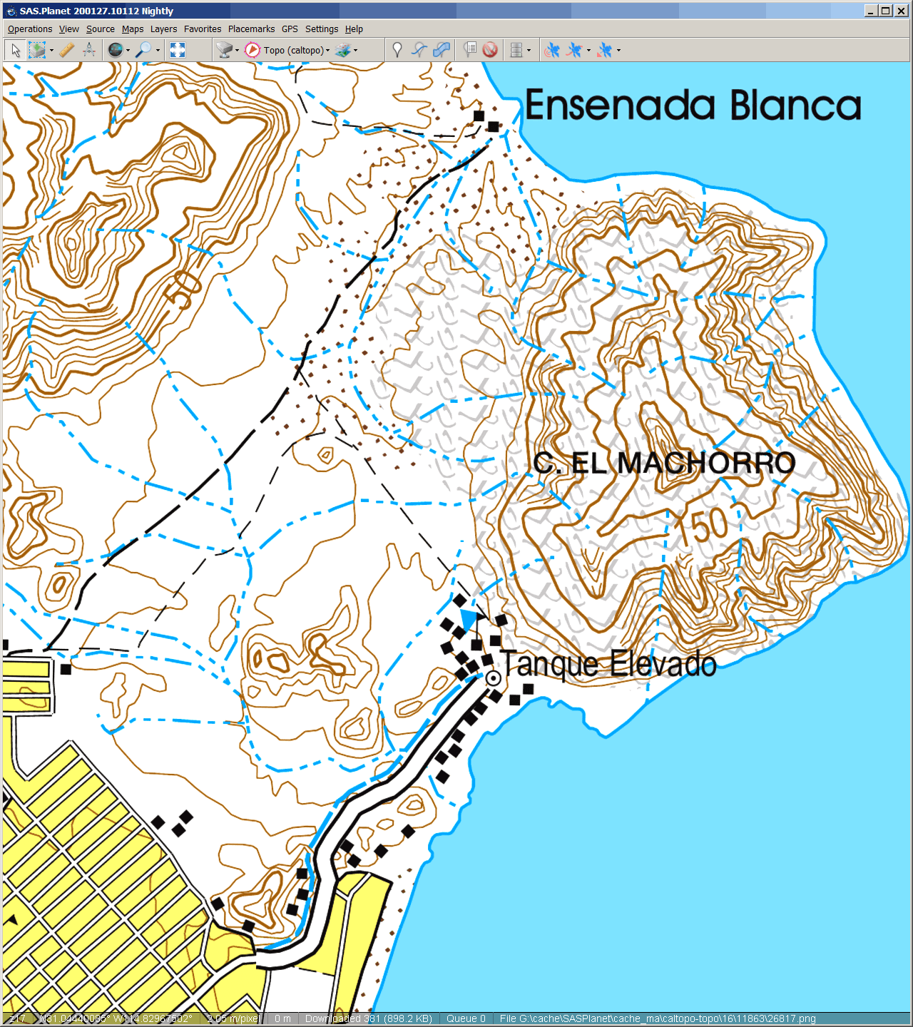
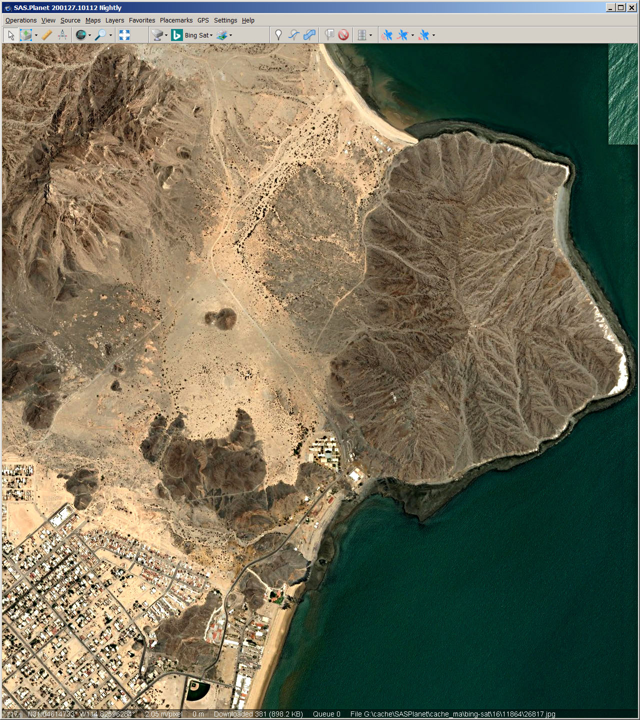
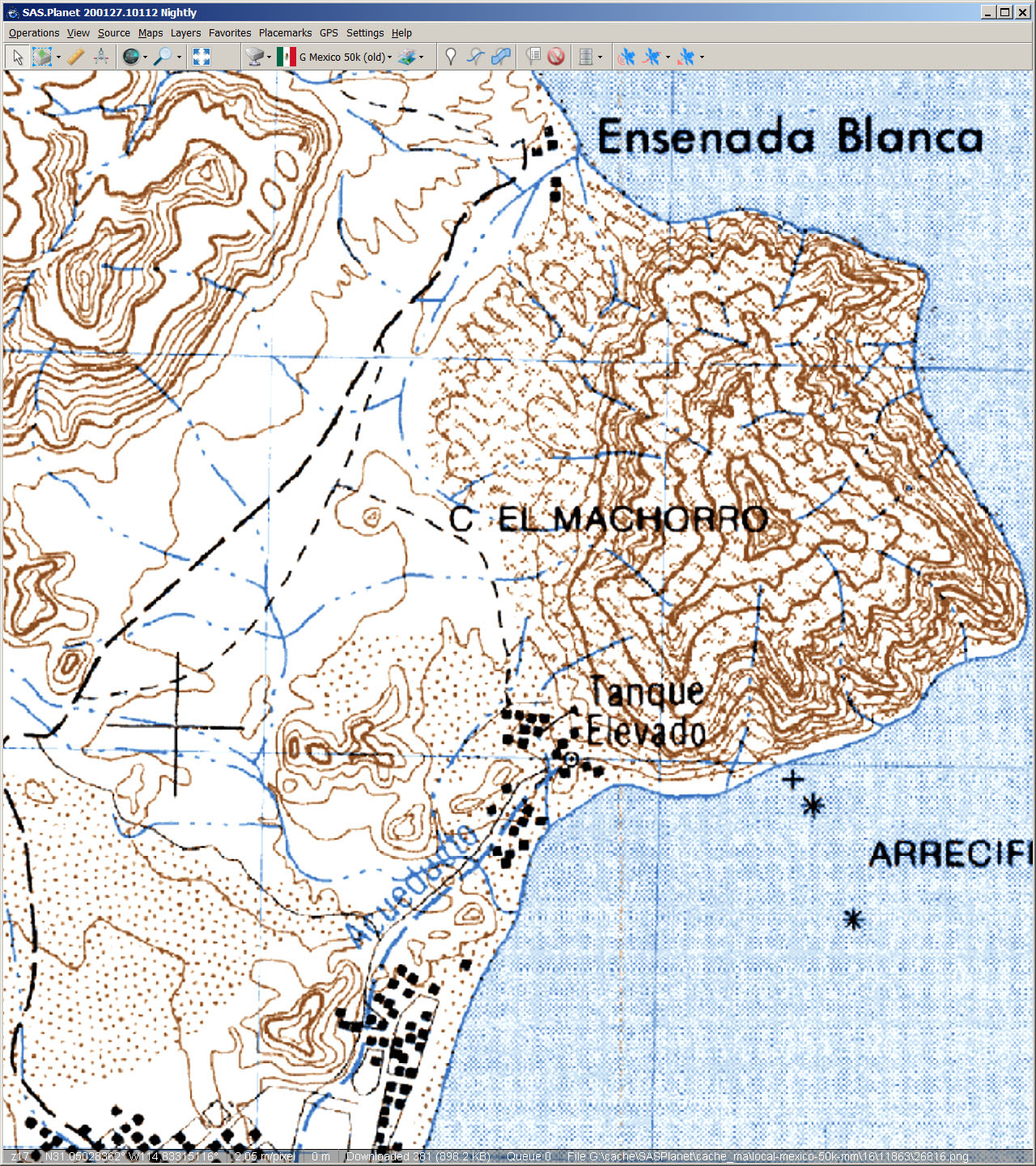
OK, here are some screenshots of the area just north of San Felipe. Click on them to see full size. OpenStreetMap, INEGI 50k, Bing satellite:
|
|
|
geoffff
Senior Nomad
Posts: 644
Registered: 1-15-2009
Member Is Offline
|
|
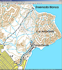
| Quote: Originally posted by PaulW | | if one chooses topo and the result is INEGI then what you get is pretty images, but no roads (or selected roads from the 1960s).
|
The INEGI maps on CalTopo have mostly been updated since the 1960s! Here is a comparison between the latest INEGI maps and some older ones. Click to
expand:
|
|
|
geoffff
Senior Nomad
Posts: 644
Registered: 1-15-2009
Member Is Offline
|
|
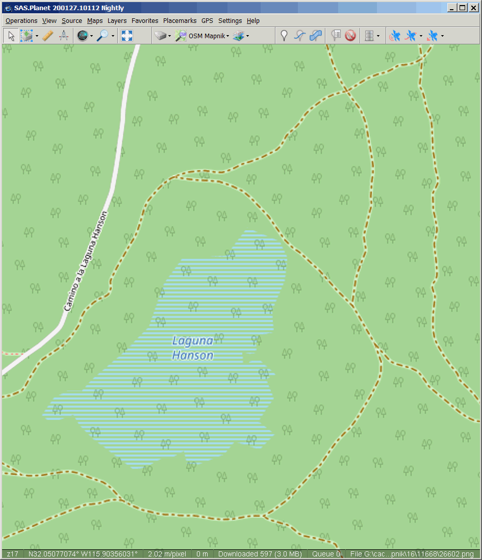
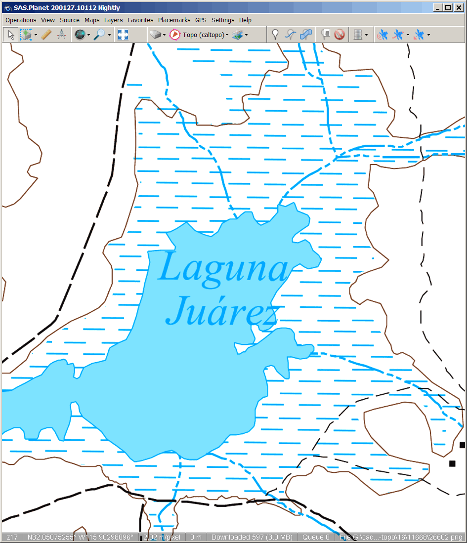
Here's another example, Laguna Hanson.
OpenStreetMap, Bing satellite.
old INEGI topo, current INEGI topo.
 
 
|
|
|
geoffff
Senior Nomad
Posts: 644
Registered: 1-15-2009
Member Is Offline
|
|
Of course, this is not Gaia GPS. Here is the above new National Geographic coverage of Picacho Del Diablo as shown in the Gaia GPS blog above compared
to the level of detail in the CalTopo INEGI maps (on my phone) of the same area:
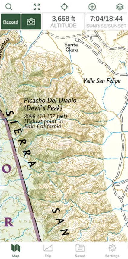 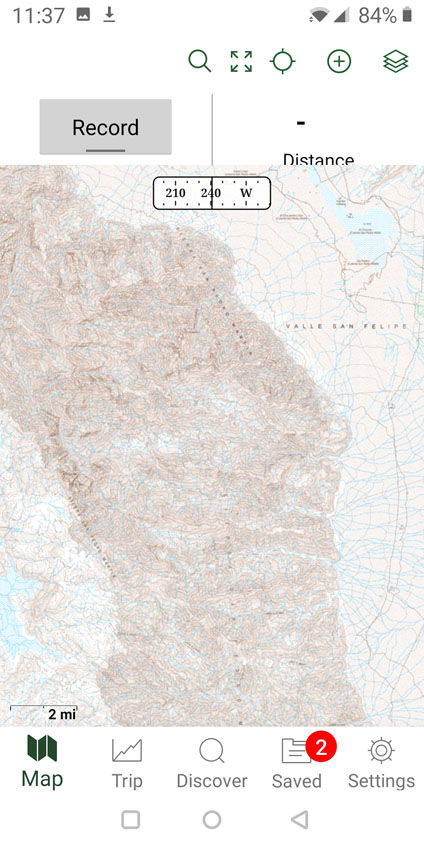
My copy of Gaia GPS doesn't yet show this new Baja update for their National Geographic maps layer, but it does have National Geographic maps in the
USA. Note that the Nat Geo map coverage seems to be limited to certain popular areas (probably not all of Baja California). See this screenshot from
my phone of southwest USA zoomed-out showing the Nat Geo coverage areas:
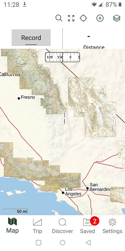
-- Geoff
|
|
|
white whale
Nomad
Posts: 157
Registered: 12-15-2015
Location: canada
Member Is Offline
|
|
| Quote: Originally posted by geoffff | OK, here are some screenshots of the area just north of San Felipe. Click on them to see full size. OpenStreetMap, INEGI 50k, Bing satellite:
|
That is a sweet combo. First thing I noticed - from the sat image shot - was the baseball park manager
must have a solid irrigation pipe out to the field. that is a some green in a sea of brown!
So for the pretend map readers , the mountain ridge shows 150 , would not guess feet or meters to my eye , this would be an approximation the
satellite software determines, real peak numbers must be human verified from the ground or reading on the peak itself?
I think a mapping tab might a good addition to the board. Every time I think about the great technology now, how great were the map makers from 2 - 3
- 4 hundred and more years ago ? And to print them too.
------------------
This ain't no party, this ain't no disco, this ain't no foolin' around Life During Wartime
- Talking Heads '79
|
|
|
mtgoat666
Select Nomad
Posts: 17341
Registered: 9-16-2006
Location: San Diego
Member Is Offline
Mood: Hot n spicy
|
|
| Quote: Originally posted by geoffff | Of course, this is not Gaia GPS. Here is the above new National Geographic coverage of Picacho Del Diablo as shown in the Gaia GPS blog above compared
to the level of detail in the CalTopo INEGI maps (on my phone) of the same area:
-- Geoff |
all of the topo maps for SPM and the peaks are fairly unreliable, the topography is pretty rugged, and important details were not captured by aerial
topo mapping methods and the scale used.
for SPM and the peaks, the written descriptions and road/trail line work on Jerry Schaad's paper map are still best available source for navigating
the SPM and the peaks.
Jerry mapped all of the old trails and roads, and if you supplement Jerry's map with a GE print-out, you will have all you need to navigate the SPM.
Most of the old roads on Jerry's map, while overgrown, can still be followed if hiking or mtn biking.
Woke!
“...ask not what your country can do for you – ask what you can do for your country.” “My fellow citizens of the world: ask not what America
will do for you, but what together we can do for the freedom of man.”
Prefered gender pronoun: the royal we
|
|
|
JZ
Elite Nomad
Posts: 9269
Registered: 10-3-2003
Member Is Offline
|
|
Satellite imagery is way better than topo's. I have all of Baja loaded on two phones and a tablet for off-line use. 100G of data per device. Use
Back Country Navigator. I like it a little better than Gaia.
Seeing yourself on a bike flying down a dirt trail in a zoomed in satellite view is incredible.
Very rarely use topos.
For roads in Baja I use Google Maps. Download Baja for offline use when you don't have cell coverage. Works great. Voice activated and turn by turn
directions.
[Edited on 5-7-2020 by JZ]
|
|
|
geoffff
Senior Nomad
Posts: 644
Registered: 1-15-2009
Member Is Offline
|
|
| Quote: Originally posted by mtgoat666 |
all of the topo maps for SPM and the peaks are fairly unreliable, the topography is pretty rugged, and important details were not captured by aerial
topo mapping methods and the scale used.
for SPM and the peaks, the written descriptions and road/trail line work on Jerry Schaad's paper map are still best available source for navigating
the SPM and the peaks.
Jerry mapped all of the old trails and roads, and if you supplement Jerry's map with a GE print-out, you will have all you need to navigate the SPM.
Most of the old roads on Jerry's map, while overgrown, can still be followed if hiking or mtn biking. |
Thanks, Goat! I didn't know about Jerry's maps. They look great! Google turned up this for me: http://dankat.com/swhikes/maps/devil.htm I do see missing topographic detail northeast of the peak in the older INEGI map, but the newer INEGI
map seems to have filled in the elevation details.
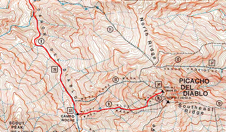
Jerry Schaud map

Old INEGI 50k topo

New INEGI 50k topo
|
|
|
JZ
Elite Nomad
Posts: 9269
Registered: 10-3-2003
Member Is Offline
|
|
Satellite imagery is also great for boating. Here is Isla Coronado in BCN on the phone.
When you are driving you see the boat moving on the image.


[Edited on 5-7-2020 by JZ]
|
|
|
| Pages:
1
2
3 |