| Pages:
1
2
3 |
geoffff
Senior Nomad

Posts: 644
Registered: 1-15-2009
Member Is Offline
|
|
Quote: Originally posted by JZ  | | Satellite imagery is way better than topo's. [...] Seeing yourself on a bike flying down a dirt trail in a zoomed in satellite view is incredible.
Very rarely use topos. |
Yes, same here! I only use the topos when planning an off-trail hiking route.
-- Geoff
[Edited on 5-7-2020 by geoffff]
|
|
|
PaulW
Ultra Nomad
Posts: 3009
Registered: 5-21-2013
Member Is Offline
|
|
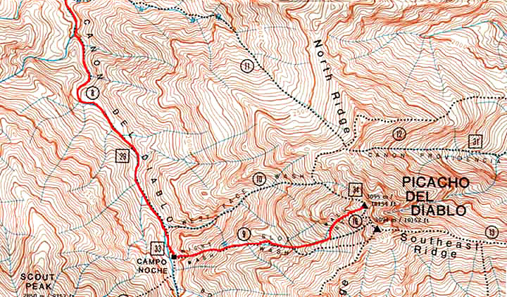
The Jerry Schaud map is dead on and works great for the hile up to teh summit
|
|
|
geoffff
Senior Nomad
Posts: 644
Registered: 1-15-2009
Member Is Offline
|
|
| Quote: Originally posted by JZ | | Satellite imagery is also great for boating. Here is Isla Coronado in BCN on the phone. When you are driving you see the boat moving on the image.
|
Sometimes I "drive by instrument" when trying to follow a faint trail that weaves through bushes I can't see over. Feels like I'm piloting a boat.
Here's what I saw on my screen when I was trying to drive out to Cantu Palms from the Laguna Salada road.
-- Geoff
|
|
|
mtgoat666
Select Nomad
Posts: 17347
Registered: 9-16-2006
Location: San Diego
Member Is Offline
Mood: Hot n spicy
|
|
| Quote: Originally posted by geoffff | | Quote: Originally posted by mtgoat666 |
all of the topo maps for SPM and the peaks are fairly unreliable, the topography is pretty rugged, and important details were not captured by aerial
topo mapping methods and the scale used.
for SPM and the peaks, the written descriptions and road/trail line work on Jerry Schaad's paper map are still best available source for navigating
the SPM and the peaks.
Jerry mapped all of the old trails and roads, and if you supplement Jerry's map with a GE print-out, you will have all you need to navigate the SPM.
Most of the old roads on Jerry's map, while overgrown, can still be followed if hiking or mtn biking. |
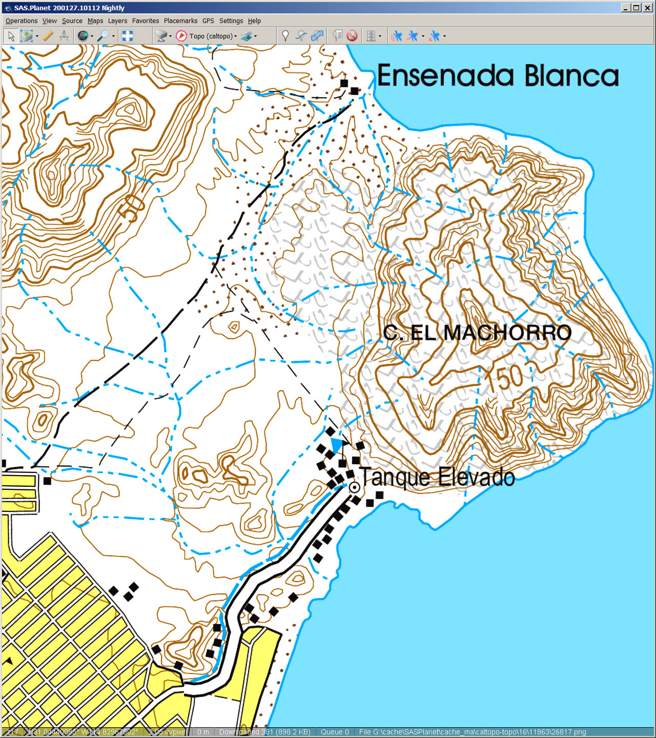
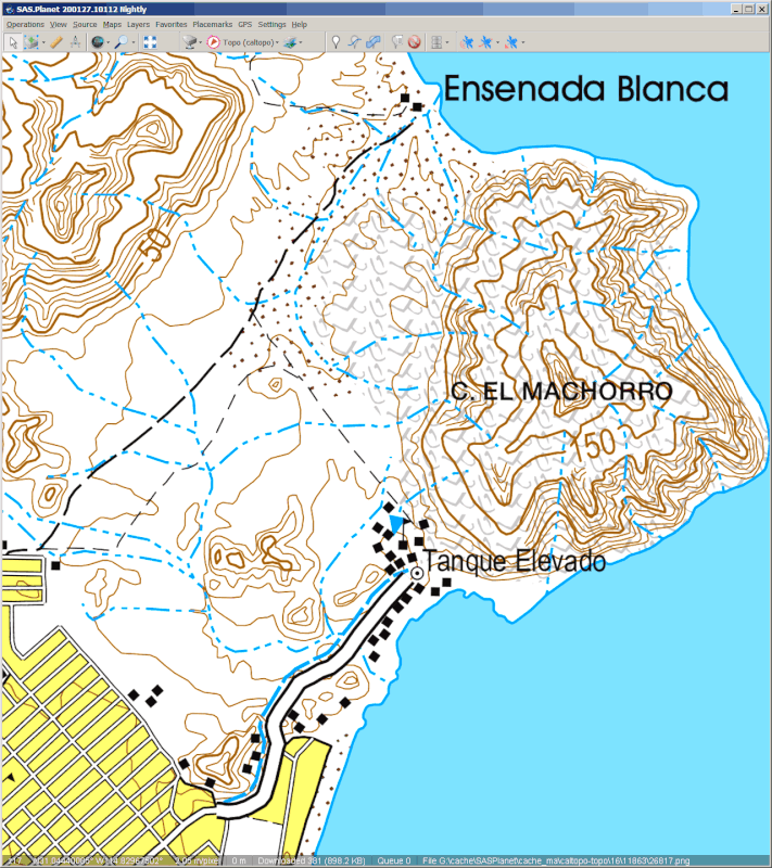
Thanks, Goat! I didn't know about Jerry's maps. They look great! Google turned up this for me: http://dankat.com/swhikes/maps/devil.htm I do see missing topographic detail northeast of the peak in the older INEGI map, but the newer INEGI
map seems to have filled in the elevation details.
Jerry Schaud map

Old INEGI 50k topo

New INEGI 50k topo
|
Jerry’s map covers entire park. It’s really the only map aid worth using when exploring the park. He showed trails and roads, and provided written
route/trail descriptions. Buy it if you can find it. Not sure if it is still in print
Woke!
“...ask not what your country can do for you – ask what you can do for your country.” “My fellow citizens of the world: ask not what America
will do for you, but what together we can do for the freedom of man.”
Prefered gender pronoun: the royal we
|
|
|
JZ
Elite Nomad
Posts: 9271
Registered: 10-3-2003
Member Is Offline
|
|
| Quote: Originally posted by geoffff |
Sometimes I "drive by instrument" when trying to follow a faint trail that weaves through bushes I can't see over. Feels like I'm piloting a boat.
Here's what I saw on my screen when I was trying to drive out to Cantu Palms from the Laguna Salada road.
-- Geoff |
We have a lot in common tech wise. I'm huge into drones as well. Wish I had your mechanical skills.
[Edited on 5-7-2020 by JZ]
|
|
|
geoffff
Senior Nomad
Posts: 644
Registered: 1-15-2009
Member Is Offline
|
|
| Quote: Originally posted by JZ | | We have a lot in common tech wise. I'm huge into drones as well. Wish I had you mechanical skills. |
Hah! Yes, sounds like it. And thanks ... but I'm not sure just how "skilled" I am mechanically, really. I'm just a computer geek who likes to get into
(and out of) mechanical trouble.
-- Geoff
|
|
|
StuckSucks
Super Nomad
Posts: 2307
Registered: 10-17-2013
Member Is Offline
|
|
| Quote: Originally posted by geoffff | The satellite imagery shows all the little unmapped tracks I'm interested in, but takes up a huge amount of storage space. For me, it's worth it.
-- Geoff |
EXACTLY my thoughts. In the outback, sat view is best for seeing the subtlety of the earth.
|
|
|
white whale
Nomad
Posts: 157
Registered: 12-15-2015
Location: canada
Member Is Offline
|
|
| Quote: Originally posted by JZ | Satellite imagery is way better than topo's. I have all of Baja loaded on two phones and a tablet for off-line use. 100G of data per device. Use
Back Country Navigator. I like it a little better than Gaia.
Seeing yourself on a bike flying down a dirt trail in a zoomed in satellite view is incredible.
Very rarely use topos.
For roads in Baja I use Google Maps. Download Baja for offline use when you don't have cell coverage. Works great. Voice activated and turn by turn
directions.
[Edited on 5-7-2020 by JZ] |
I'm stumped, so you can take a static SAT image area, then overlay a clear GPS map so the pings can draw a line or you just have a single moving
cursor point? And you must be able to record this then to view like you say.
That does sound slick.
This ain't no party, this ain't no disco, this ain't no foolin' around Life During Wartime
- Talking Heads '79
|
|
|
JZ
Elite Nomad
Posts: 9271
Registered: 10-3-2003
Member Is Offline
|
|
| Quote: Originally posted by white whale |
I'm stumped, so you can take a static SAT image area, then overlay a clear GPS map so the pings can draw a line or you just have a single moving
cursor point? And you must be able to record this then to view like you say.
That does sound slick.
|
1. You have the sat image. Basically just like Google Earth (GE). Can zoom in and out
2. Overlay it with tracks and way points that you have. I build tracks on GE and import them.
3. It shows your position on the sat image and where you are related to your tracks and way points
4. You can record a track and that shows as well (includes lots of stuff, avg moving speed, max speed, max/min altitudes, total trip duration, etc.)
Back Country Navigator is what I use. There are a bunch of videos on YouTube that show you how to import tracks and download map sections for offline
use (e.g. no cell coverage).
[Edited on 5-8-2020 by JZ]
|
|
|
white whale
Nomad
Posts: 157
Registered: 12-15-2015
Location: canada
Member Is Offline
|
|
| Quote: Originally posted by JZ | | Quote: Originally posted by white whale |
I'm stumped, so you can take a static SAT image area, then overlay a clear GPS map so the pings can draw a line or you just have a single moving
cursor point? And you must be able to record this then to view like you say.
That does sound slick.
|
1. You have the sat image. Basically just like Google Earth (GE). Can zoom in and out
2. Overlay it with tracks and way points that you have. I build tracks on GE and import them.
3. It shows your position on the sat image and where you are related to your tracks and way points
4. You can record a track and that shows as well (includes lots of stuff, avg moving speed, max speed, max/min altitudes, total trip duration, etc.)
Back Country Navigator is what I use. There are a bunch of videos on YouTube that show you how to import tracks and download map sections for offline
use (e.g. no cell coverage).
[Edited on 5-8-2020 by JZ] |
I'm still getting the hang of My Maps . Google Earth is next.. Yes just have seen a few YT clips on this process. So you record the GPS route on
your phone and marry that to the G E map of the same area? I didn't think you could could get those images from an area unless the area had street
view capability.
I'd like to see a clip of the biking you mentioned.
This ain't no party, this ain't no disco, this ain't no foolin' around Life During Wartime
- Talking Heads '79
|
|
|
geoffff
Senior Nomad
Posts: 644
Registered: 1-15-2009
Member Is Offline
|
|
| Quote: Originally posted by white whale | | I'm still getting the hang of My Maps . Google Earth is next.. Yes just have seen a few YT clips on this process. So you record the GPS route on
your phone and marry that to the G E map of the same area? I didn't think you could could get those images from an area unless the area had street
view capability. |
Street View and Satellite View are different. Street View images are taken from a car driving around on streets.
This is not usually helpful for backcountry exploring.
The default 3D imagery shown in Google Earth is satellite or aerial imagery. Google Earth uses a 3D elevation model of the world to display these 2D
photos taken from space in 3D.
Other apps can also show this same satellite imagery, but usually not in 3D.
Hope this helps,
-- Geoff
|
|
|
geoffff
Senior Nomad
Posts: 644
Registered: 1-15-2009
Member Is Offline
|
|
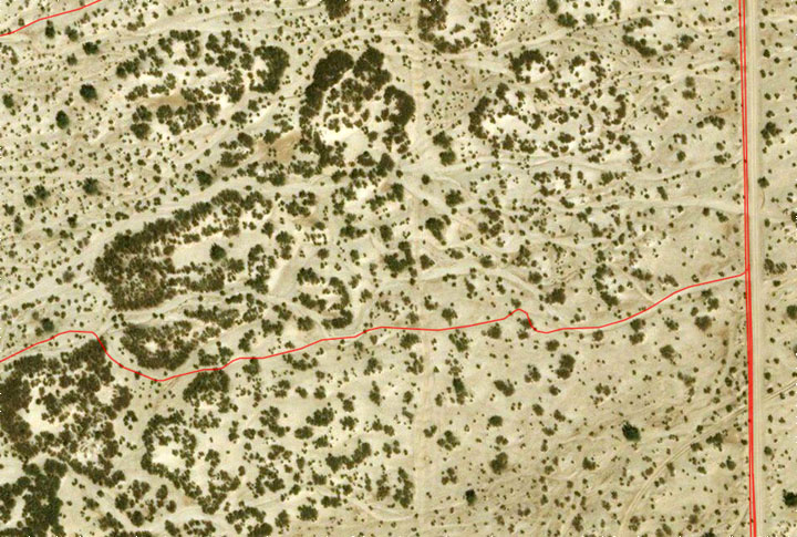
So, yes you can take a GPS track you recorded, bring it into Google Earth later on, and see it in on a 3D model of the world with satellite imagery.
Also, if you know where you'll be going ahead of time, you can also take that same satellite imagery, download it to your GPS/phone, and take it with
you on your trip. Then you can see as you move about on your trip your real-time location and track (in 2D) overlaid on that satellite imagery.
|
|
|
PaulW
Ultra Nomad
Posts: 3009
Registered: 5-21-2013
Member Is Offline
|
|
comparing images
San Felipe area
Post by Geoffff
Screen shot from my GPS

Hanson Area
Post by Geoffff
Screen shot from my GPS

GPS shows real roads that have been driven. So other images are not as good as the good old GPS.
Geoffff, can you provide better detail from your sources than you posted?
|
|
|
David K
Honored Nomad
Posts: 64494
Registered: 8-30-2002
Location: San Diego County
Member Is Offline
Mood: Have Baja Fever
|
|
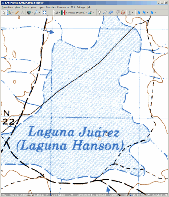
Hanson or Hansen ??
It's Hanson, per the historic records  
*Laguna Hanson: A shallow lake named after an American rancher who arrived in the area in 1872 and who was murdered in 1880, nearby, at Rancho El
Rayo. A fellow American named Harvey was found guilty of killing Hanson and cooking his remains in a large cast iron pot.
|
|
|
geoffff
Senior Nomad
Posts: 644
Registered: 1-15-2009
Member Is Offline
|
|
| Quote: Originally posted by PaulW | comparing images
GPS shows real roads that have been driven. So other images are not as good as the good old GPS.
Geoffff, can you provide better detail from your sources than you posted?
|
No, this is the most detail provided by the INEGI map series.
Your GPS does the best job (by far) of showing the most road detail! What GPS do you have? Did those tracks come included on your GPS map, or did you
have to install them? Or are they your own vehicle-recorded tracks?
The images were: Modern INEGI Mexico topo, vs. your GPS:
Old 1970s INEGI Mexico topo vs. your GPS:
  
-- Geoff
[Edited on 5-14-2020 by geoffff]
|
|
|
geoffff
Senior Nomad
Posts: 644
Registered: 1-15-2009
Member Is Offline
|
|
The INEGI topo maps are the Mexican government's equivalent to our USGS topographic maps.
I initally downloaded them as PDFs and JPEGs from Mexico the INEGI website https://www.inegi.org.mx/ These PDFs were then processed into image tiles. The tiles are now hosted by the Caltopo website.
I use a program ("SAS.Planet") on Windows (which is like Gaia GPS on the phone) to download these tiles and display them as maps on my tablet computer
|
|
|
PaulW
Ultra Nomad
Posts: 3009
Registered: 5-21-2013
Member Is Offline
|
|
Hi Geoff,
I use Murdocknav map on a Lowrance Gen2 HDS7 in my Jeep. The black and white images I posted have the same detail but from a very old Lowrance GPS
that I keep on my desk either in Baja or here in CO. Now days Lowrance has changed their mapping SW for the Gen3 and Murdock has apparently given up
on updating. Probably due the high license fees by Lowrance. BTW, Murdock makes no effort to show topo data -just roads. And he makes the same mistake
we all do to create a road which is really a river/drainage when making a trail using Google Earth. Murdock uses a collection of both roads driven by
the racer community and by creating tracks from Google Earth. Most of my odd ball tracks I have made over the years are now included in Murdok map.
Murdock collects these contributions from many others and select the track of interest that has the best detail.
Using Murdock map on a Lowrance results in full detail, but for Garmin the maps are filtered due to low memory and unique SW.
Anyway, for the diehard GPS folks the Murdoc maps still work and are the best for Baja I can find (so far). (murdocknav.com)
I have another platform using an android tablet that has more roads for Baja. While the screen has better presentation, the map is crude. That map has
one huge disadvantage because it is a collection of roads from every map the author could find. The result is many of the roads no longer exist. Then
the author dumbed down the resolution due to memory size by filtering tracks and you know the result - bad. The map is given to friends of the author.
For my use in the states I slap the tablet on top of the Lowrance and use various maps, Maps.me, Google maps, or Earthmate. And I choose the one that
is best (showing the most roads) for the location where I wheel. I am always looking for better maps.
My observation about USGS and INEGI is that I love the images, but neither are as useful as Google earth to make a future track to drive. Anyway
except for topo lines the darn things are way too old to depict anything else.
|
|
|
geoffff
Senior Nomad
Posts: 644
Registered: 1-15-2009
Member Is Offline
|
|
Thank you! I had not run across Murdocknav yet.
| Quote: Originally posted by PaulW | | My observation about USGS and INEGI is that I love the images, but neither are as useful as Google earth to make a future track to drive. Anyway
except for topo lines the darn things are way too old to depict anything else. |
Agreed!
I'd love to get that compilation of the Murdocknav GPS tracks in GPX or KMZ format, but am less interested in the trails he creates from studying
Google Earth imagery (mistaken drainages and all).
In any case, since I don't run a standalone Garmin or Lowrance unit, I'll likely stick to using satellite imagery. Unfortunately they aren't as easy
to see in bright sunlight as the lines of a map. I might give Murdocknav's Lowrance maps a try if I can figure out how to convert them to GPX or KMZ
formats. I'll play with the sample Lowrance LCM file on his website and see what I can do with it.
[Edited on 5-15-2020 by geoffff]
|
|
|
John M
Super Nomad
Posts: 1907
Registered: 9-3-2003
Location: California High Desert
Member Is Offline
|
|
converting files
Geoff - I use GPS Track Maker to convert files.
I usually convert kml to Lowrance usable .usr files but they have options for gpx and many other formats.
Or......that's not what you are talking about.
It's worked flawlessly for us.
John M
|
|
|
David K
Honored Nomad
Posts: 64494
Registered: 8-30-2002
Location: San Diego County
Member Is Offline
Mood: Have Baja Fever
|
|
I am DIGGING the MAP discussions here!!!
Not to sidebar this, but good things will be happening soon for Baja map lovers who need more than my maps show and less than all the technical stuff
that is not easy for a few of us old time, paper map fans!
Also, I have been adding to VivaBaja.com more zoomable map links and links to historic photos.
Baja California, Mexico 'Zoom-In' Topo & Satellite Map
1905-1906 E.W. Nelson Expedition 'Zoom-In' Map (printed in 1919)
1918 Goldbaum Baja Norte 'Zoom-In' Map (printed in 1925)
1962 Baja road maps by Howard Gulick (thanks to Doug Eernisse)
1971 Reconnaissance Geologic Map of Baja Norte (3 parts):
.........Northern Baja Norte
.........Central Baja Norte
.........Southern Baja Norte
Mexican Topographic Maps from INEGI
(choose scale, area, and click PDF or GeoPDF where available)
Exciting New El Camino Real Website and Google Earth Map
-------------------------------------------------------------------------
Peveril Meigs' Northern Baja Photos from 1925 to 1936
Howard Gulick's Baja photo collection from the 1950's and 60's
Many more of Howard Gulick's (and Harry Crosby's) Photos
Harry Crosby's Photos and El Camino Real Details
[Edited on 5-15-2020 by David K]
|
|
|
| Pages:
1
2
3 |