| Pages:
1
2
3 |
PaulW
Ultra Nomad

Posts: 3009
Registered: 5-21-2013
Member Is Offline
|
|
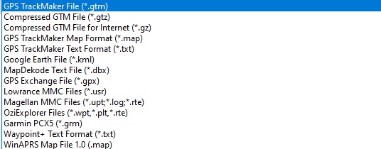
There are a host of tools that can be used to convert file formats. I also use Trackmaker mainly due to ease of use. Most tools are free, but all do a
good job of converting TRACKS (not maps) from one format to another. Here is an image of the Trackmaker save options. The list allows going either
way but just the output files are listed. Note for latest Trackmaker Lowrance track format is missing so a different tool is required if you want Gen3
GPS conversions.
I have not used OZI Explorer enough so I cannot brief the reader on OZI conversion options. Ozi has GE type images that are much more readable on my
PC. OZI cost is $99US.
Notice the Lowrance map format (LCM) is not listed.
Now you can see why I always like a KML in order to create a track. Converting KMZ to KML is an extra step.
David could tell us his format maybe we could use this tool or other available took to convert to our favorite format.
|
|
|
David K
Honored Nomad
Posts: 64493
Registered: 8-30-2002
Location: San Diego County
Member Is Offline
Mood: Have Baja Fever
|
|
My mapping was done with inReach Explorer and then visually seeing the roads I was on in satellite images and drawing a line over the roads I wanted
to include on my 30 maps. The base map only had the paved highways and cities. All dirt roads I had to draw in and other place names, too. I really
liked that since the website maps have so many errors in place names. The mapping website is ArcGIS and after drawing the roads in, I can change the
base map from satellite to terrain or other base maps and my lines transfer when I change the base map. I used WORD to add in place names and other
symbols I have on my maps (John M was a big help in finding or creating the symbols I used, highway names, airports, gas pumps, etc.). It was a LOT of
work. I am very happy with how they turned out. The only area of Baja that I traveled for the guide and did not make a map for was the Laguna Hanson/
Sierra Juarez region. Just ran out of energy... that trip was the last and happened in 2018 after I had made the others.
I just looked at ArcGIS and I don't see the base map I used offered anymore... So, bummer for that.
[Edited on 11-8-2020 by David K]
|
|
|
bajaric
Senior Nomad
Posts: 605
Registered: 2-2-2015
Member Is Offline
|
|
Speaking of maps, thanks to Geoff for new Caltopo Baja maps, also DK for putting INEGI maps on VivaBaja web site. excellent!
One question; Why no mine symbols? The Baja Almanac has many mine symbols, and I assumed it was sourced from INEGI. Anyone know a free on line map
that shows mines, for those without a Baja Almanac?
[Edited on 11-8-2020 by bajaric]
|
|
|
PaulW
Ultra Nomad
Posts: 3009
Registered: 5-21-2013
Member Is Offline
|
|
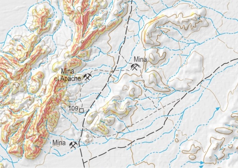
use Inegi the mines are there
Example
These instructions worked several years ago
INEGI Map Download instructions
Stay with me in Spanish
Go to inegi.org.mx
Mouse on Geografia
Mouse on Temas
Mouse on Topografia
Click on Cartas topograficas
In the clave box enter your map number like H11B36
Click Consuiltar
Bottom of page is your map choices
Click on the pdf symbol for the newest version
2003 ITRF92 and let the file go to the desktop
Keep clicking until the desktop file looks like a PDF color picture. Duh
Try this
Double click on the file and then select to choose the application then choose PDF
Close the error messages and open the file on your desktop and view the topo map.
Use the usual PDF featured to get the zoom level and location you want.
To use these instructions you need the key for the maps. I cannot find the key at this time. Search Nomads for that key.
Also try https://topogeek.com/mexico/
[Edited on 11-9-2020 by PaulW]
[Edited on 11-9-2020 by PaulW]
|
|
|
David K
Honored Nomad
Posts: 64493
Registered: 8-30-2002
Location: San Diego County
Member Is Offline
Mood: Have Baja Fever
|
|
The Inegi website has the grid for maps of Mexico once you click on the scale you want (1:50,000 for example): https://www.inegi.org.mx/temas/topografia/
You can use geoffff's Caltopo map for finding mines, too... and you can zoom in using his...
|
|
|
PaulW
Ultra Nomad
Posts: 3009
Registered: 5-21-2013
Member Is Offline
|
|
Good one David. I gave up trying to use Geofff link to find a mine.
The grid lines are on the sides of the PDF so it is time consuming to get the coords for particular place by labeling the grids at your place of
interest at the zoom level you need. Even then you have to estimate between grids. It works, but I don't do it much anymore.
|
|
|
David K
Honored Nomad
Posts: 64493
Registered: 8-30-2002
Location: San Diego County
Member Is Offline
Mood: Have Baja Fever
|
|
Quote: Originally posted by PaulW  | Good one David. I gave up trying to use Geofff link to find a mine.
The grid lines are on the sides of the PDF so it is time consuming to get the coords for particular place by labeling the grids at your place of
interest at the zoom level you need. Even then you have to estimate between grids. It works, but I don't do it much anymore. |
Right... So many maps... so little time!
|
|
|
StuckSucks
Super Nomad
Posts: 2307
Registered: 10-17-2013
Member Is Offline
|
|
Gaia has a map layer called Mines and Mineral Resources. While it displays a ton of mines in the US, it only displays a small handful of mines in
Baja.
By tapping on one of the mines on the map, you can learn all sorts of info, including a link to the USGS Mineral Resources Data System.
FYI the lines on the map was a map I built to direct me to this very remote location on the CA/NV border.


|
|
|
bajaric
Senior Nomad
Posts: 605
Registered: 2-2-2015
Member Is Offline
|
|
Thanks for the help with my obscure mapping question. It prompted me to revisit the INEGI web site, (link above) and what I found was that mine
symbols can be hit an miss on the INEGI maps (and also Caltopo, which is based on the INEGI maps) Interestingly, some of the older (1974) 1:50,000
INEGI maps have excellent detail for mines in certain areas, then in later years the symbols disappear off the maps.
On the other hand, in some areas there no mine symbols in places where I know there are mines. One example is the Pioneer Mine. As far as I can
determine, this mine on the Pioneer trail south of Pozo de Lacy is not shown on any version of the INEGI maps, the BCA, or Caltopo.
Anyhow, thanks for the help, now if I can just get some of you rock crawler 4x4 guys on speed dial to pull me out when my F150 gets stuck!
|
|
|
David K
Honored Nomad
Posts: 64493
Registered: 8-30-2002
Location: San Diego County
Member Is Offline
Mood: Have Baja Fever
|
|
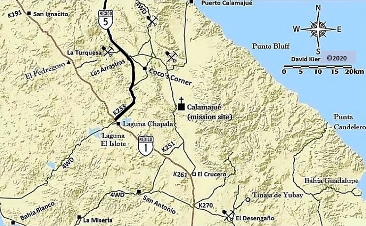
Lucky for us, Howard Gulick put it on his 1956-1962 maps...

I show it (but without the name) on my 2018 map...
[Edited on 11-10-2021 by David K]
|
|
|
StuckSucks
Super Nomad
Posts: 2307
Registered: 10-17-2013
Member Is Offline
|
|
| Quote: Originally posted by PaulW | Good one David. I gave up trying to use Geofff link to find a mine.
The grid lines are on the sides of the PDF so it is time consuming to get the coords for particular place by labeling the grids at your place of
interest at the zoom level you need. Even then you have to estimate between grids. It works, but I don't do it much anymore. |
If I understand correctly you have a difficult time figuring out lat/lon for a particular location?
CalTopo makes it super easy to get info at a location. Simply right-click to pull up a menu -- select position and elevation to see the coordinates
you seek, in different formats.


|
|
|
| Pages:
1
2
3 |


