PaulW
Ultra Nomad

Posts: 3005
Registered: 5-21-2013
Member Is Offline
|
|
Clarifying the Pole Line Road track
Planning another trip
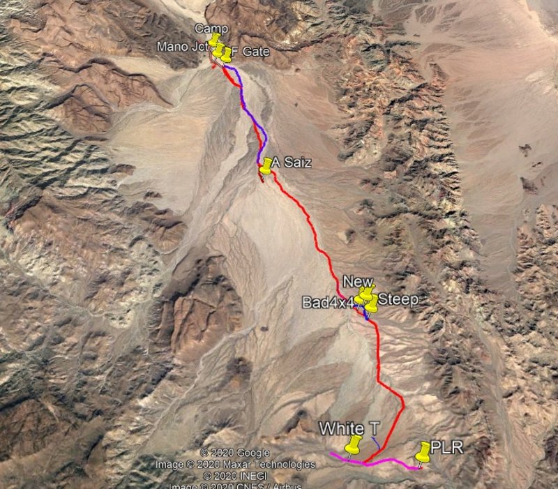
Revised Pole Line Road
Revised to avoid the rancher's locked gate and his substantial fence. The new track begins just east of White tank and follows the abandoned pipeline.
The track heads north with a some mild difficulties and lots of turns. It stays on the plateau then drops in to Arroyo Enmedio and follows all the
arroyo all the way to Mano Junction.
From Mano junction there are well known ways to either highway 5, or highway 2D, or even over Mano summit to Indepencia on highway 3. The previous way
from Mano junction over the so-called race summit is no longer possible due to a substantial gate. I have not found a go around for that gate.
The track downhill in A. Enmedio (northbound) has many either-or options that all go the same place and are shown on my track.
Note – if driving South on this new track be sure to avoid entering Arroyo Saiz as shown. There are ridges between the two arroyos that are not
obvious on Google Earth.
Attached is the Google earth KML file. Be sure to use the zoom feature to see the details at the confusing places for my various trials to find the
way. If you put the track in your GPS you will be able to find your way. If you go by images you make from the KML file - good luck. Yup, it gets
tricky to miss the various turns. After many of you drive the new track it will become much easier to follow.
Attachment: New WT to Mano Jct.kml (219kB)
This file has been downloaded 249 times
[Edited on 10-27-2020 by PaulW]
|
|
|
TMW
Select Nomad
Posts: 10659
Registered: 9-1-2003
Location: Bakersfield, CA
Member Is Offline
|
|
Good job Paul, thanks.
|
|
|
Ken Cooke
Elite Nomad
Posts: 8921
Registered: 2-9-2004
Location: Riverside, CA
Member Is Offline
Mood: Black Trans Lives Matter
|
|
Thanks for the file. The go-around were very tricky in the washes near the Mano Junction. But, the ranchers looked very angry the time my group
drove directly up to their house and had to turn around back in 2005. Whoops.
They live where the cow trough intersects the original entrance. Just continue East and in just a few minutes, you'll be in their driveway! The
go-around avoids their ranch and a few others, and takes the driver to the White (water) Tanks, quite a ways from the scenic Sierra Juarez escarpment
and closer to Canon Enmedio, the cobblestone route, and all of the fun sections along the Pole Line Road.
Here are some highlights from February 2019

The Laguna Salada

En route to Cohabuzo Junction at 32.012, -115.628

Looking back towards the Sierra Juarez escarpment, nearing the White (water) Tanks


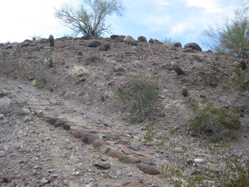
'Perfect Cobblestone Hill' as described by the late Neal Johns (RIP)


Crawling Canon Enmedio in low range


Dusk over the Pole Line Road - rain was forecast during the entire week of our Baja trek. The weather was cold and damp the entire week.

Sunrise over the Pole Line Road during a particularly chilly morning.

You can never go wrong with an ER Surgeon on-board.

Basketball Hill


Leaving the Arroyo Jaquegel/Approaching 'Bad Hill'

Atop 'Bad Hill' approaching the steep dropoff on the other side - facing Hwy 5

[Edited on 10-12-2020 by Ken Cooke]
|
|
|
PaulW
Ultra Nomad
Posts: 3005
Registered: 5-21-2013
Member Is Offline
|
|
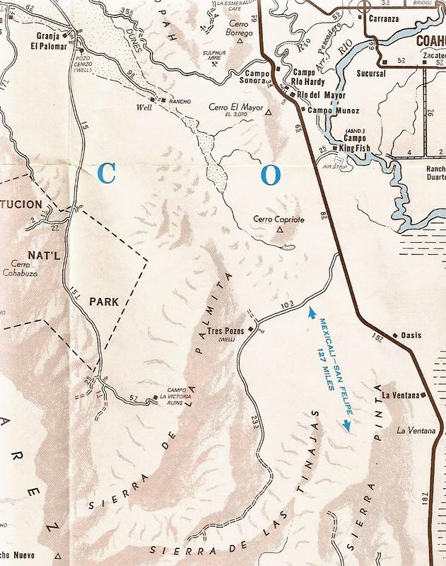
Been to Campo Victoria? I guess so. The Johns coords are 31 45.6, -115 33.4 (probably NAD27 Mx). That plots with slight error on an old SCORE road I
have driven several times and Ken used that road several times on earlier PLR trips. Anyway nothing to report just more dry desert.
That Image on the AAA pretty inaccurate per the Johns discussion.
Quote: Originally posted by David K  | Nice!
Have you been to Campo La Victoria (ruins) out there? It was shown on the older AAA maps and Neal Johns checked it out(use Nomad search).
[Edited on 10-11-2020 by David K] |
[Edited on 10-12-2020 by PaulW]
|
|
|
PaulW
Ultra Nomad
Posts: 3005
Registered: 5-21-2013
Member Is Offline
|
|
I wonder if the way to agua Caliente is anywhere near the area?
And yes go thru the fence gate and keep right to find the road in question. West and shortly south then when the road turns east that would be the
coordinated we posted.
|
|
|
Ken Cooke
Elite Nomad
Posts: 8921
Registered: 2-9-2004
Location: Riverside, CA
Member Is Offline
Mood: Black Trans Lives Matter
|
|
Campo Victoria or no Campo Victoria, I'm wanting to get out there bad. The Pole Line Road beckons. It will probably be best to run the trail in
about one year, is my thinking. Until then, I'll be planning, building one rig, and fine tuning the other.
|
|
|
Jeep Baja
Newbie
Posts: 1
Registered: 10-14-2020
Member Is Offline
|
|
Fun read on a new part of Baja for us. I met Ken on his 2017 Impossible trip, somewhere around Gonzaga.
Saw the articles of the trips down the Powerline trails and wonder if you have or know of where we could find a GPX for Gaia. There is group of us
planning on a trip down there in April of next year.
Also, how do you get out at the end of the southern end of the trail, back to Gonzaga?
Thanks.
Paul Santana
|
|
|
PaulW
Ultra Nomad
Posts: 3005
Registered: 5-21-2013
Member Is Offline
|
|
I wonder which trail you mean?
The Pioneer Mine trail is the second most difficult trail in that area. Search nomads for that trail and download the GPS track that was posted.
There are several ways to find the south end. If you have an off road map for the area near Coco's you will see various roads.
There is another difficult trail that goes for the Gonzaga area to Hwy 1. Wait for some else to post those details.
If you do not find a GPS track - don't go.
Btw. When you figure out where you want to go start another thread which is not related to the Pole Line Road.
[Edited on 10-14-2020 by PaulW]
|
|
|
David K
Honored Nomad
Posts: 64480
Registered: 8-30-2002
Location: San Diego County
Member Is Offline
Mood: Have Baja Fever
|
|
The Pole Line Road was a telephone line service road, built in 1942 to install the communications link to our radar station near San Felipe. It runs
mostly west to east where Ken and others drive it for the 4X4 challenge and history.
Once the Japanese threat was reduced, we turned it over to the Mexican military.
The east end of the run is very near La Ventana on Hwy. 5, and that was the way many of us exited after our 2015 run with Ken...
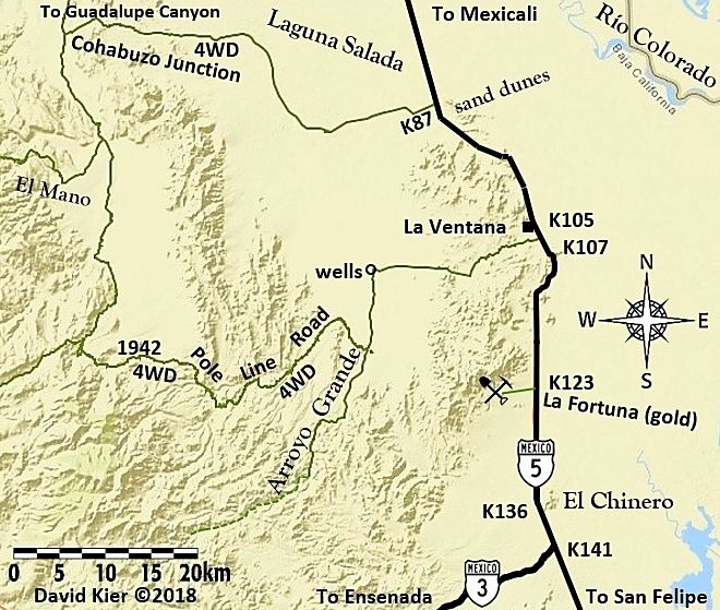
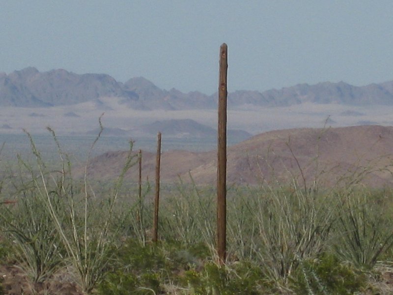
Cobblestone paving, 78-year-old telephone poles, and glass insulators are just some of the great sites!

My article on Pole Line Road: https://www.bajabound.com/bajaadventures/bajatravel/pole_lin...
[Edited on 10-14-2020 by David K]
|
|
|
David K
Honored Nomad
Posts: 64480
Registered: 8-30-2002
Location: San Diego County
Member Is Offline
Mood: Have Baja Fever
|
|
| Quote: Originally posted by PaulW | I wonder which trail you mean?
The Pioneer Mine trail is the second most difficult trail in that area. Search nomads for that trail and download the GPS track that was posted.
There are several ways to find the south end. If you have an off road map for the area near Coco's you will see various roads.
There is another difficult trail that goes for the Gonzaga area to Hwy 1. Wait for some else to post those details.
If you do not find a GPS track - don't go.
Btw. When you figure out where you want to go start another thread which is not related to the Pole Line Road.
[Edited on 10-14-2020 by PaulW] |
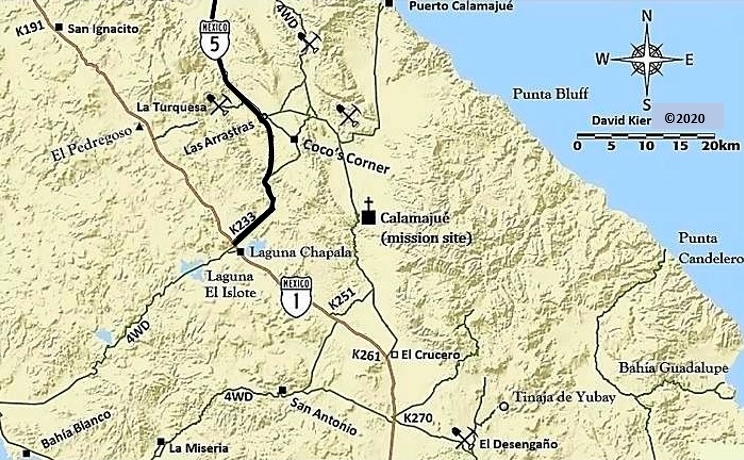
The south end of the Pioneer Mine trail joins the graded road from Coco's Corner to Puerto Calamajué or short cut to Las Arrastras. I show it as a
4WD road and the mine symbol next to the '4WD' is the Pioneer Mine...
[Edited on 10-14-2020 by David K]
|
|
|
TMW
Select Nomad
Posts: 10659
Registered: 9-1-2003
Location: Bakersfield, CA
Member Is Offline
|
|
David I just read your article on the Pole Line Road in Baja Bound and thought it was great. I thought the road was never finished before the war
ended and therefore it was abandoned. If it was finished where did they finish at. You stated the southern end was 35 miles north of San Felipe but
where was the other end, at the summit?
|
|
|
David K
Honored Nomad
Posts: 64480
Registered: 8-30-2002
Location: San Diego County
Member Is Offline
Mood: Have Baja Fever
|
|
Hi Tom,
Thank you!
I wrote that back in 2015 after we Nomads did the run.
During Covid, Baja Bound is republishing old favorites.
The road built in 1942 that we drove part of was to install and service the telephone line to the San Felipe radar base. There was a road between
Ensenada and San Felipe. So, the new road was from that one, over the summit, and met the new Mexicali to San Felipe road, north of El Chinero.
|
|
|
PaulW
Ultra Nomad
Posts: 3005
Registered: 5-21-2013
Member Is Offline
|
|
I have always had a lingering question where the pole line went at each end.
We know the telephone line was continuous, but any roads are now undefined at each end. Example from the last broken post west of Arroyo Grande to the
place known as the Ice house in San felipe no pole remains have been found so far. Yes there are roads going east from Arroyo Grande to what I call
Pinta pass and then to Chinero and to the Ice house are. Any of the roads are possible for the pole line route. In addition there were facilities
further south with no pole lines remains found.
At the west end it is all speculation since no pole remains have been located anywhere near the mountain passes. It is a long way from the last pole
to where the pole line crossed the mountains. The only road that is plausible would probably be the so called race summit. But back in the 1940s all
the three summits were drivable. After the mountains going west then what David said there apparently was an existing road all the way to the west
coast.
|
|
|
David K
Honored Nomad
Posts: 64480
Registered: 8-30-2002
Location: San Diego County
Member Is Offline
Mood: Have Baja Fever
|
|
A piece of a pole was found just outside of San Felipe by the two mountains next to town. I was sent a photo of the cut pole.
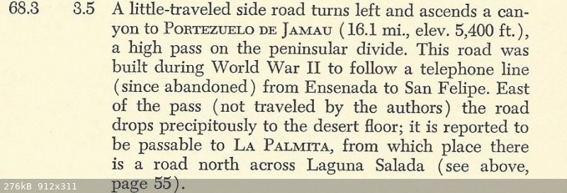
The Lower California Guidebook so very well documented all the dirt roads in the 1950s... at the 'summit' road was made/ graded for the telephone
line... it was only a foot and horse path previous.
Here is from the 1956 (First Edition) Lower California Guidebook by Peter Gerhard & Howard Gulick in the chapter on the Ensenada to San Felipe
road...
|
|
|
David K
Honored Nomad
Posts: 64480
Registered: 8-30-2002
Location: San Diego County
Member Is Offline
Mood: Have Baja Fever
|
|
In 1960 or '61, Howard Gulick and others drove and logged the entire route down the summit and the road made famous by Nomads Neal Johns and Ken Cooke
after many trips. The road log appears in the 1962, Third Edition of the guidebook.
|
|
|
Ken Cooke
Elite Nomad
Posts: 8921
Registered: 2-9-2004
Location: Riverside, CA
Member Is Offline
Mood: Black Trans Lives Matter
|
|
I am wanting to return again, but my last series of runs featured a group who came to crash much of the event. They were helpful when it came to
helping a disabled Jeep SUV get back to San Felipe after running into electrical issues.
|
|
|
David K
Honored Nomad
Posts: 64480
Registered: 8-30-2002
Location: San Diego County
Member Is Offline
Mood: Have Baja Fever
|
|
| Quote: Originally posted by Ken Cooke | I am wanting to return again, but my last series of runs featured a group who came to crash much of the event. They were helpful when it came to
helping a disabled Jeep SUV get back to San Felipe after running into electrical issues.
|
Keep the meet-up/ starting location in Baja a secret (using email or u2u only once you have the maximum number of guests for your event).
Maybe reverse the direction of the run so you can enjoy the interesting section (poles, cobblestone paving, Bad Hill, Basketball Hill)
before having to deal with or avoid locked gates, which are all on the west end of the run?
|
|
|
PaulW
Ultra Nomad
Posts: 3005
Registered: 5-21-2013
Member Is Offline
|
|
I just edited the original post to fix my errors. I want to point out the the real Arroyo Saiz is even more to the west than Shown. Seems like I
deleted to many tracks.
Anyway if you saved the original text, please save it again.
|
|
|


