David K
Honored Nomad

Posts: 64479
Registered: 8-30-2002
Location: San Diego County
Member Is Offline
Mood: Have Baja Fever
|
|
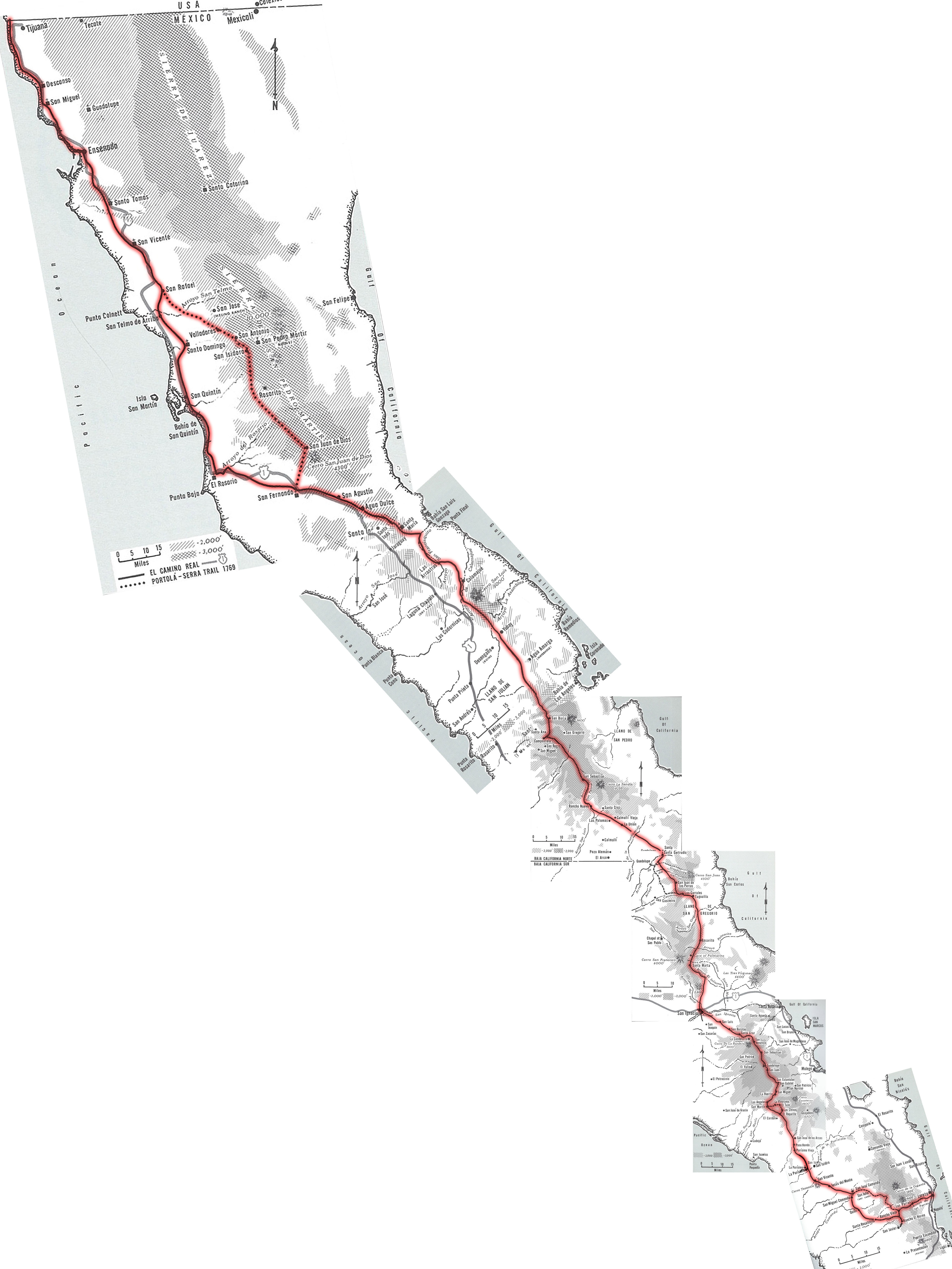
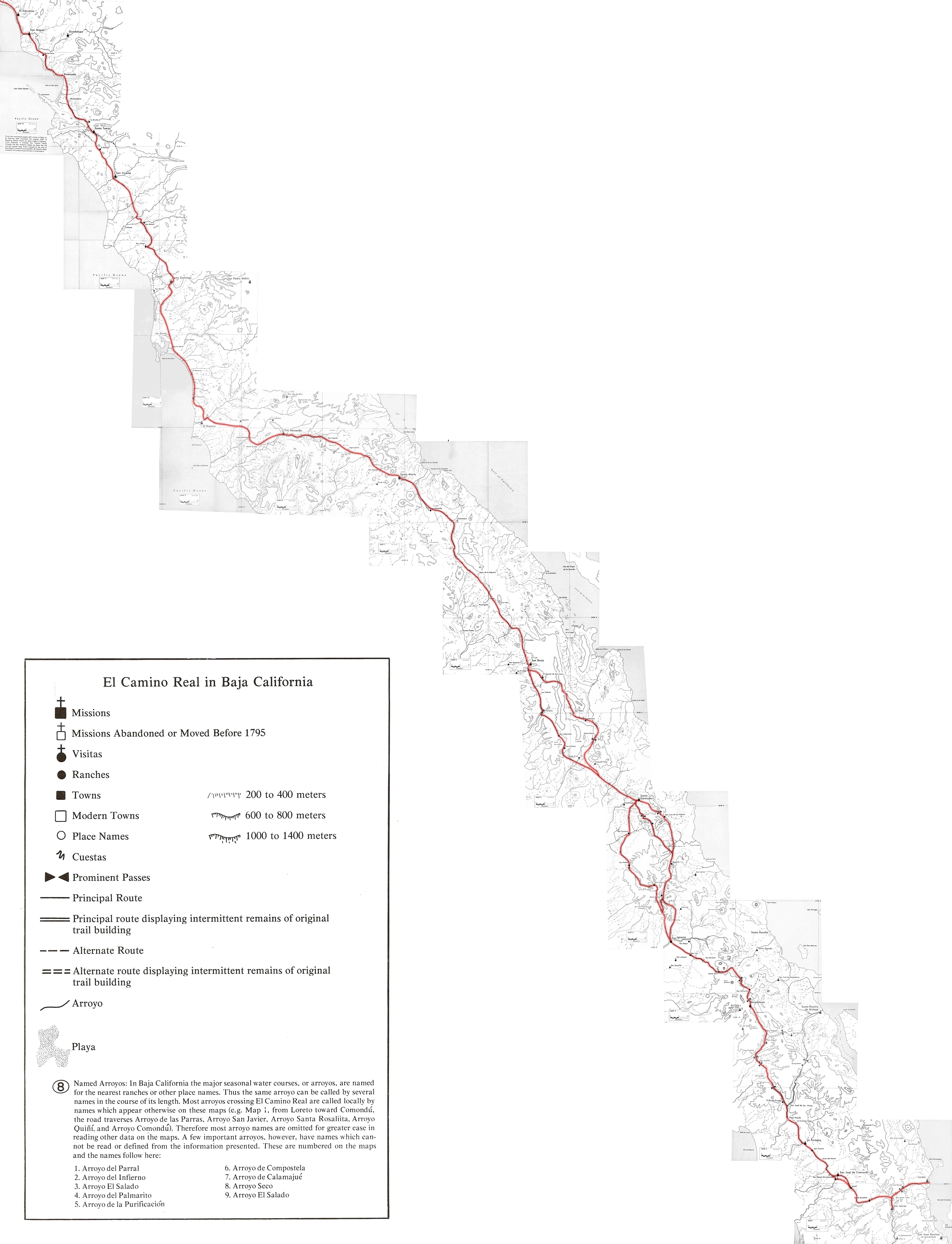
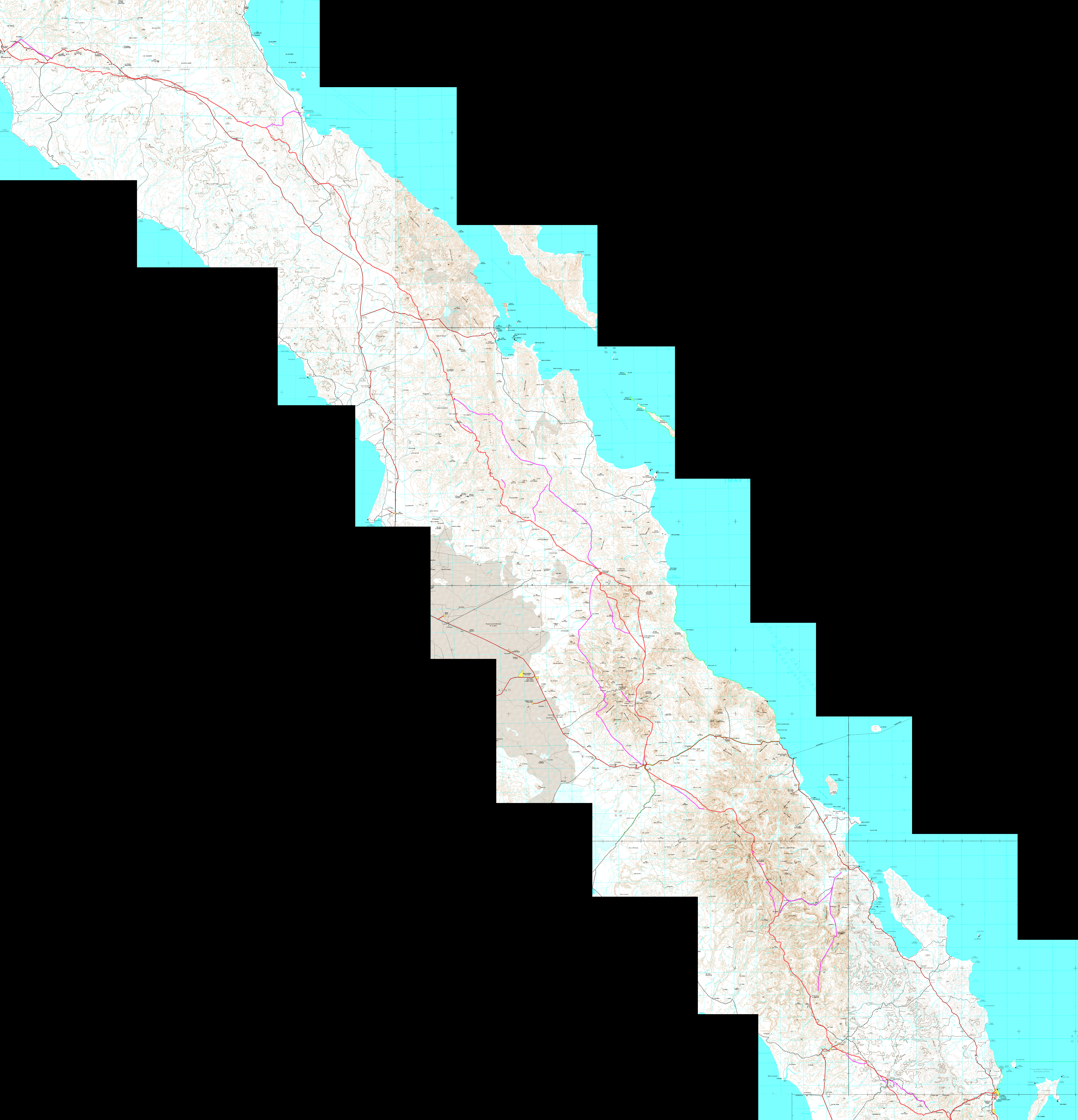
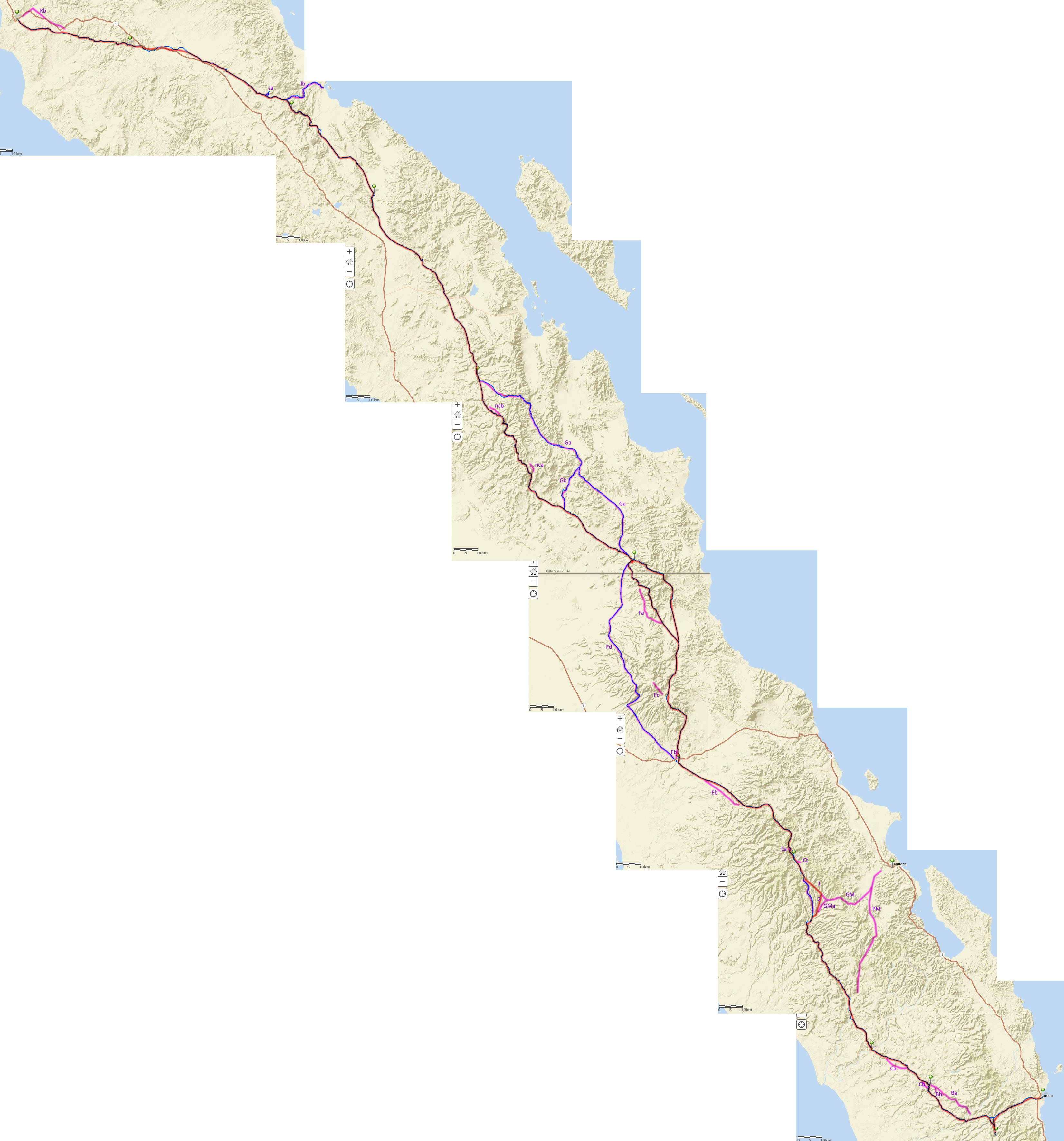
EL CAMINO REAL MAPS, stitched together by geoffff:
We sure have a wonderful trip reporter and map maker with 'geoffff'!
His latest creations are with the maps showing the route of El Camino Real in Baja California. Geoffff has stitched together the multiple ECR maps and
put them in a zoomable format for study.
In 1954, Howard Gulick, while researching for the Lower California Guidebook, noted and connected sections of the mission trail where he saw it cross
the auto roads or where locals informed him of it.
In 1974, Harry Crosby (with assistance from Howard Gulick and his maps) wrote the King's Highway in Baja California. The maps were not highly
detailed.
In 1977, Harry commissioned the cartography department at the university, to produce more-detailed maps of the route.
From about 2000 to 2018, a Washington couple ground-proofed the original mission roads from Loreto to El Rosario and created a Google Earth map at www.caminorealbaja.com
Baja Nomad geoffff made a track from their hundreds of waypoints and placed it on an INEGI topo map.
I also had created a line over their points on my base map... I hope to see it included as a thing of interest on the new Baja Map Book I am helping
edit.
Click on the map when it opens to enlarge for detail:
1954 Maps: http://octopup.org/img/misc/davidk/ecr/ecr-maps-3.jpg
1974 Maps: http://octopup.org/img/misc/davidk/ecr/ecr-maps-2.jpg
1977 Maps: http://octopup.org/img/misc/davidk/ecr/ecr-maps-1.jpg
2018 CaminoRealBaja Maps: http://octopup.org/img/misc/davidk/ecr/caminorealbaja-com-tr...
2019 David K ECR track maps: http://octopup.org/img/misc/davidk/ecr/ecr-davidk.jpg
[Edited on 1-20-2021 by David K]
|
|
|
BajaTed
Senior Nomad
Posts: 859
Registered: 5-2-2010
Location: Bajamar
Member Is Offline
|
|
In La Mision by Magana's restaurant next to the river bed . You can see on the south hillside the carved Basalt steep portion of the El Camino Real.
Locals referred to it as the "old Stagecoach road"
Es Todo Bueno
|
|
|
David K
Honored Nomad
Posts: 64479
Registered: 8-30-2002
Location: San Diego County
Member Is Offline
Mood: Have Baja Fever
|
|
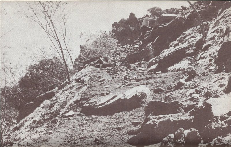
Quote: Originally posted by BajaTed  | | In La Mision by Magana's restaurant next to the river bed . You can see on the south hillside the carved Basalt steep portion of the El Camino Real.
Locals referred to it as the "old Stagecoach road" |
Thanks, yes... Walt Wheelock mentioned it in his 1971 book, 'Byroads of Baja'... with this photo:
|
|
|
bajaric
Senior Nomad
Posts: 602
Registered: 2-2-2015
Member Is Offline
|
|
I wonder why there were two trails from Santa Gertrudis to San Borja. Gabb described traveling on the western trail, passing through Calmalli Viejo
and San Sebastian in 1867, but why would there be another trail to the east?
[Edited on 12-16-2020 by bajaric]
|
|
|
BajaTed
Senior Nomad
Posts: 859
Registered: 5-2-2010
Location: Bajamar
Member Is Offline
|
|
There is not much controversy about the southern portion of the Camino Real.
But; if you watch the FNX channel (first native TV) , they say the whole northern portion is a contrived story within the grand "Mission Play" created
to justify what occurred to their culture . The counter narrative is not a pretty picture and it was not the version I heard in the 4th grade.
#metooelcaminoreal
Es Todo Bueno
|
|
|
David K
Honored Nomad
Posts: 64479
Registered: 8-30-2002
Location: San Diego County
Member Is Offline
Mood: Have Baja Fever
|
|
| Quote: Originally posted by bajaric | I wonder why there were two trails from Santa Gertrudis to San Borja. Gabb described traveling on the western trail, passing through Calmalli Viejo
and San Sebastian in 1867, but why would there be another trail to the east?
[Edited on 12-16-2020 by bajaric] |
Seasonal weather/ water availability along the trail is one reason for west vs. east as well as a need by the padre to visit certain outposts visitas.
Some are on one route and others on the other route.
There were actually three El Camino Reals in some places. They are called 'Sierra Camino Real' if in the center or mountains; 'Golfo Camino Real' on
the east side of the sierras; and 'Pacifico Camino Real' if they wanted a beer... no, wait, if on the west side of the mountains!
Also, newer roads replaced older in places. Look closely at the many trails radiating out from San Ignacio. It looks like the spokes of a wheel. The
maps do not have all the Camino Reals but we can read about other routes. The Pacifico Camino Real from Santa Gertrudis to San Borja is an interesting
one. The three routes between San Ignacio and Santa Gertrudis are the best known and on the maps.
|
|
|
David K
Honored Nomad
Posts: 64479
Registered: 8-30-2002
Location: San Diego County
Member Is Offline
Mood: Have Baja Fever
|
|
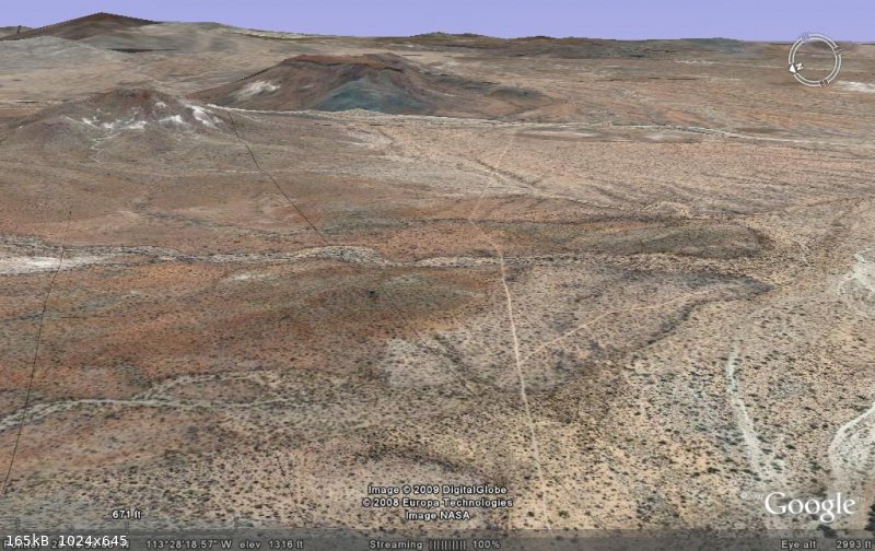
Fun to fly over the Jesuit's road on Google Earth!
The first three are going south from San Borja.
The fourth is looking south where it crosses the El Arco/ Pta San Francisquito road. To the north, it has been made into an auto road (to Rancho La
Unión).
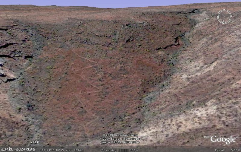 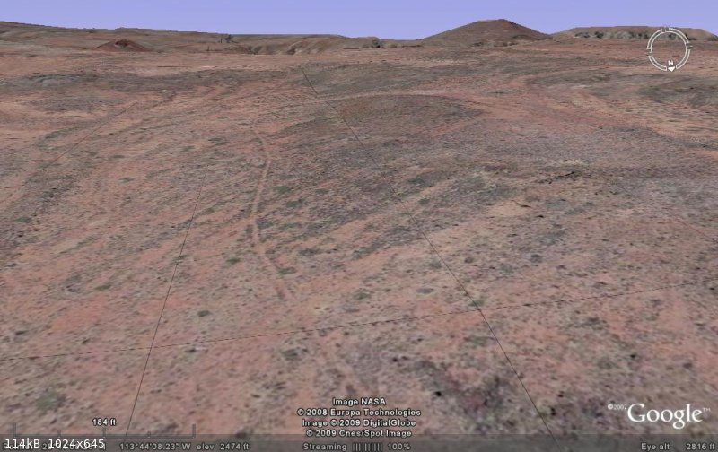 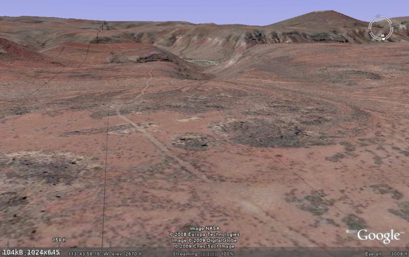 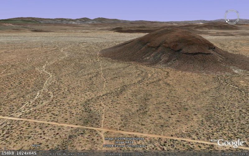
Often, the Camino Real runs very straight, well-engineered. In the Winter 1977, Journal of San Diego History, besides the maps, are details on the
road building.
|
|
|
David K
Honored Nomad
Posts: 64479
Registered: 8-30-2002
Location: San Diego County
Member Is Offline
Mood: Have Baja Fever
|
|
In Baja California during the mission period, El Camino Real was only passable on foot or on hoof, no wagons (as far as I know). Just too many steep
cuestas (grades/ switchbacks).
History is full of bad and evil events, but to stop teaching it because it offends someone is really a disservice to society... and an injustice to
the future.
|
|
|
bajaric
Senior Nomad
Posts: 602
Registered: 2-2-2015
Member Is Offline
|
|
Cool images! Seems so dry and barren, no wonder the missionaries stayed close to water holes.
I wasn't saying that the missionaries had wagons. That was the whole point; they had to find a route with water holes spaced within one days travel,
on foot or on hoof. I imagine they did not have very good water carrying devices, either. Maybe a animal bladder, or an old leaky keg or clay jug.
By the late 1800's it was possible to carry more water, especially on a wagon. By the late 1800's they had factory made iron fittings and stuff, to
make water tight kegs, and wagon roads replaced portions of the El Camino Real.
[Edited on 12-16-2020 by bajaric]
|
|
|
David K
Honored Nomad
Posts: 64479
Registered: 8-30-2002
Location: San Diego County
Member Is Offline
Mood: Have Baja Fever
|
|
Yes, as mining expanded, wagon roads were built and new routes around mountains bypassed the Camino Real which went through the mountains in the most
direct line between missions as possible.
|
|
|
David K
Honored Nomad
Posts: 64479
Registered: 8-30-2002
Location: San Diego County
Member Is Offline
Mood: Have Baja Fever
|
|
Not sure if you heard the new Slow Baja podcast yesterday, but it sounds like the U.N. is about to add (Baja) California's El Camino Real as a World
Heritage site.
|
|
|
TacoFeliz
Nomad
Posts: 265
Registered: 7-22-2005
Location: Here
Member Is Offline
Mood: Exploratory
|
|
| Quote: Originally posted by David K |
History is full of bad and evil events, but to stop teaching it because it offends someone is really a disservice to society... and an injustice to
the future. |
Well said David.
Are there .kml files of the ECR routes available anywhere? I'd love to be able to view them on Google Earth.
Tanx
|
|
|
David K
Honored Nomad
Posts: 64479
Registered: 8-30-2002
Location: San Diego County
Member Is Offline
Mood: Have Baja Fever
|
|
| Quote: Originally posted by TacoFeliz | | Quote: Originally posted by David K |
History is full of bad and evil events, but to stop teaching it because it offends someone is really a disservice to society... and an injustice to
the future. |
Well said David.
Are there .kml files of the ECR routes available anywhere? I'd love to be able to view them on Google Earth.
Tanx
|
Yes, the tracks were made from the waypoints on the Google Earth map at www.caminorealbaja.com
To see all the waypoints, spread the timeline pointers apart.
Attachment: ecr-all.kmz (28kB)
This file has been downloaded 192 times
|
|
|
David K
Honored Nomad
Posts: 64479
Registered: 8-30-2002
Location: San Diego County
Member Is Offline
Mood: Have Baja Fever
|
|
The El Camino Real route(s) between Loreto and El Rosario will be included in the new 2021 Baja California Atlas. They will be shown as faint dashed
lines, labeled as "Historic El Camino Real" and "ECR".
|
|
|
mtgoat666
Select Nomad
Posts: 17294
Registered: 9-16-2006
Location: San Diego
Member Is Offline
Mood: Hot n spicy
|
|
| Quote: Originally posted by David K | | Quote: Originally posted by TacoFeliz | | Quote: Originally posted by David K |
History is full of bad and evil events, but to stop teaching it because it offends someone is really a disservice to society... and an injustice to
the future. |
Well said David.
Are there .kml files of the ECR routes available anywhere? I'd love to be able to view them on Google Earth.
Tanx
|
Yes, the tracks were made from the waypoints on the Google Earth map at www.caminorealbaja.com
To see all the waypoints, spread the timeline pointers apart.
|
The info on www.caminorealbaja.com is quite fascinating.
Their Kmz files are 100x more informative than the maps in this thread.
Genevieve Mattar and Kevin Branscum are the real deal, true explorers. They get out of their cars and see the country (No motorcycles too), and they
post a really cool Kmz report of their exploration
Woke!
“...ask not what your country can do for you – ask what you can do for your country.” “My fellow citizens of the world: ask not what America
will do for you, but what together we can do for the freedom of man.”
Prefered gender pronoun: the royal we
|
|
|
David K
Honored Nomad
Posts: 64479
Registered: 8-30-2002
Location: San Diego County
Member Is Offline
Mood: Have Baja Fever
|
|
Yes indeed! They have been backpacking on ECR for 20 years to 'ground proof' the true mission road from the 'imposters'. It has been a great joy to
chat with Kevin and to get his permission to put their work onto the new Baja Atlas maps. The 2018 and 2019 maps, linked above, are thanks to Kevin
and Genevieve.
Of interest, the final section that was unclear to them, discovered in 2018, was north from Calamajué to Las Arrastras/ San Francisquito.
|
|
|


