| Pages:
1
2 |
DouglasP
Nomad

Posts: 320
Registered: 6-23-2018
Member Is Offline
Mood: Goat hunter.
|
|
Punta Chivato to the Pacific, off road
Here is another can you get to there from here threads.
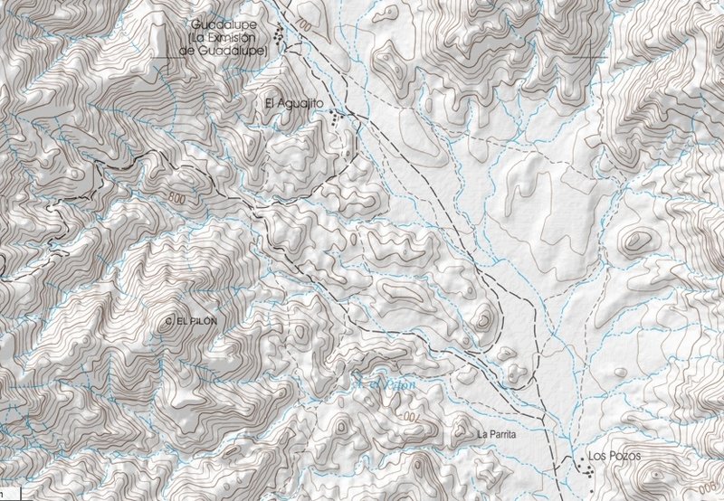
Gone from PC or Mulege to the Pacific via San Ramundo wash lots of times. Looking for another route.
I tried yesterday, leading a group of side by sides. I have been looking on maps and google maps and there is a trail that takes off west at the
Guadelupe mission ruins. Found the trail, but didn't get too far up it. Came to a locked gate. Looks like a fairly new addition. No signage at all
saying private property. Also, just to the left of it was the typical barbed wire gate with a loop holding it closed, but it was only wide enough for
a moto or horse!
You can see on the attached file we tried going up to the trail by another way, but it was washed out.
Really looking to make my way over to the Pacific some way besides San Raymundo/La Bellena. Any help?
Trip was still fun, ended up at Baja Brewing in Mulege for beers and dinner!
Attachment: up and over.kml.kmz (41kB)
This file has been downloaded 244 times
I like beer, better than most people.
|
|
|
AKgringo
Elite Nomad
Posts: 5807
Registered: 9-20-2014
Location: Anchorage, AK (no mas!)
Member Is Offline
Mood: Retireded
|
|
Well that is unfortunate, but good to know. I was hoping to explore that route on my next trip, but was going to try it from the west, heading east.
I may try it anyway, but will plan on the possibility of a U-turn trip! I will report what I find, but don't stand by, it will be a while!
If you are not living on the edge, you are taking up too much space!
"Could do better if he tried!" Report card comments from most of my grade school teachers. Sadly, still true!
|
|
|
DouglasP
Nomad
Posts: 320
Registered: 6-23-2018
Member Is Offline
Mood: Goat hunter.
|
|
Well I may have an answer for you if you take too long! My thought was to come at it from the west also.
I like beer, better than most people.
|
|
|
motoged
Elite Nomad
Posts: 6481
Registered: 7-31-2006
Location: Kamloops, BC
Member Is Offline
Mood: Gettin' Better
|
|
Doug,
I have ridden west to east.....if you can find el Patrocino on a map (Almanac) ....take it to San Juan de la Pila, head E and you end up just south of
the Guadalupe ruins.....and head south to San Estanislao junction....then east to Mulege.
Killer ride.....
[Edited on 2-22-2021 by motoged]
Don't believe everything you think....
|
|
|
DouglasP
Nomad
Posts: 320
Registered: 6-23-2018
Member Is Offline
Mood: Goat hunter.
|
|
That looks like the trail I was headed out east on. If you follow it on google earth it goes out by Patrocino. Super bummed it has a gate now.
The trail also shows up on the National Geographic Baja maps.
I like beer, better than most people.
|
|
|
motoged
Elite Nomad
Posts: 6481
Registered: 7-31-2006
Location: Kamloops, BC
Member Is Offline
Mood: Gettin' Better
|
|
I did it in 2011....double track the whole way, but some had only been travelled by horse for some years and was ROUGH....lotsa basketball sized
rocks....
I was on an overloaded 690....ran out of water half-way, and was bonked by Guadalupe area.... made it to La Serenidad just before dark....had started
in San Ignacio with a group of about 10 guys....
The ride was one of the trip reports I recently posted here.
Don't believe everything you think....
|
|
|
Jinete Viejo
Junior Nomad
Posts: 88
Registered: 1-23-2017
Member Is Offline
|
|
Looks like you were trying to get to San Pedro Canyon. A few years ago that was beyond rough (almost impassible) on a light weight motorcycle. If it
hasn't been fixed, that gate did you a big favor.
Attachment: San Pedro for Nomads.gdb (207kB)
This file has been downloaded 150 times
|
|
|
Jinete Viejo
Junior Nomad
Posts: 88
Registered: 1-23-2017
Member Is Offline
|
|
If either of the tracks shown in the file attached above are now passable between the gate you mentioned and El Patrocino, it would be good news.
|
|
|
DouglasP
Nomad
Posts: 320
Registered: 6-23-2018
Member Is Offline
Mood: Goat hunter.
|
|
Jinete, I'm not able to open the file you attached. What do you use to open it.
I like beer, better than most people.
|
|
|
David K
Honored Nomad
Posts: 64479
Registered: 8-30-2002
Location: San Diego County
Member Is Offline
Mood: Have Baja Fever
|
|
Douglas, what was the dead end "washed out" like? Looks to be the main road that the one with the "locked gate" connects to?
Both roads shown on the CalTopo map...
|
|
|
MulegeAL
Nomad
Posts: 298
Registered: 8-25-2009
Location: PDX/Mulege
Member Is Offline
|
|
Doug,
I was in there from the west side during the major rain event last March.
The eastbound climb east of rancho San Marcos/ San Pedro/ Las Tunas is completely destroyed by hurricanes and is abandoned. Do not waste your time or
endanger yourself attempting this dotted line on an old map. The westbound side above the gate you found is equally bad.
We hiked up a bunch of the western side climb and then retreated only to get caught by rain and mud, made it back to San Ig 1100 PM.
I can show you a way out south to San Isidro that is less bad, if you haven't done that before. Goes south up Chuparossa canyon, then down, then up
again to hit the junction of road to rancho Guajademi, then south through Rio de Janerio/ El Hondo. 67 miles M to San Isidro. No guarantees the top
is passable, but can guarantee it will be rough.
[Edited on 2-23-2021 by MulegeAL]
|
|
|
David K
Honored Nomad
Posts: 64479
Registered: 8-30-2002
Location: San Diego County
Member Is Offline
Mood: Have Baja Fever
|
|
Mulegé to San Isidro (La Purísima) direct route videos
West of Guajademi...
https://youtu.be/HWxj5HHQXic
https://vimeo.com/146502907
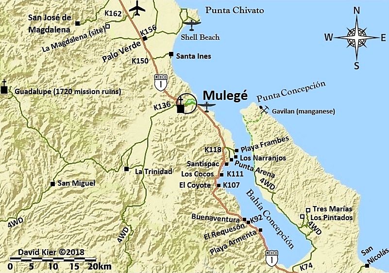
Early version of my map, included this road with a "4WD" along it. I removed that section of road in a later version as it was not one I drove or
included in the Baja Bound road guide... at least the first edition of it.
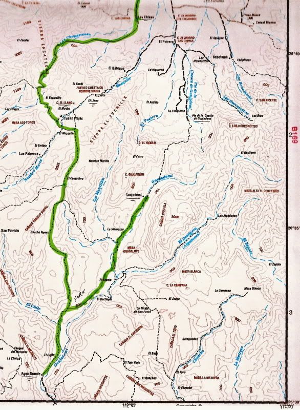
Before it was on maps we were using on Nomad, I added it in on the Baja Topo Atlas from Landon Crumpton. I also highlighted the road to Guajademi. The
dashed line north of there is an El Camino Real trail and not passable by vehicle going down the mountain.
|
|
|
AKgringo
Elite Nomad
Posts: 5807
Registered: 9-20-2014
Location: Anchorage, AK (no mas!)
Member Is Offline
Mood: Retireded
|
|
It sounds like the Patrocino to Guadalupe section is beyond the capabilities of my stock vehicles!
If you are not living on the edge, you are taking up too much space!
"Could do better if he tried!" Report card comments from most of my grade school teachers. Sadly, still true!
|
|
|
TMW
Select Nomad
Posts: 10659
Registered: 9-1-2003
Location: Bakersfield, CA
Member Is Offline
|
|
The old road that went from El Patrocino to Guadalupe was washed out from San Juan de la Pila east by a hurricane in 2014. There is another road that
bypasses San Juan de la Pila to the north and comes back to the old road. It goes to Ranch Las Tunas closest to Guadalupe. But from R. Las Tunas to
Guadalupe is only for horses according to the ranch owner. Some biker guys made it thru a few years ago but had to do a lot of lifting and carrying
the bikes over bolders.
The trail from Mulege to San Isidro is a great run if open.
|
|
|
Jinete Viejo
Junior Nomad
Posts: 88
Registered: 1-23-2017
Member Is Offline
|
|
To answer Douglas P's earlier question: The file is a Garmin GDB file. You can open it with Base Camp or convert it to KMZ (Google Earth format) with
GPS Visualizer. Let me know if you need help doing that.
|
|
|
David K
Honored Nomad
Posts: 64479
Registered: 8-30-2002
Location: San Diego County
Member Is Offline
Mood: Have Baja Fever
|
|
Can you make it a kmz?
|
|
|
geoffff
Senior Nomad
Posts: 643
Registered: 1-15-2009
Member Is Offline
|
|
San Pedro for Nomads.kmz
|
|
|
geoffff
Senior Nomad
Posts: 643
Registered: 1-15-2009
Member Is Offline
|
|

|
|
|
DouglasP
Nomad
Posts: 320
Registered: 6-23-2018
Member Is Offline
Mood: Goat hunter.
|
|
Lots of replies here, thanks.
The trail over to San isidro open, have done that trail a couple times, as recently as January last year. Rough for sure, but doable. We did it in
side by sides. Spent the night in comondu and back to PC the next day. Good fun.
Geoff, thanks for the conversion on the file.
Jinete, it looks like I was on the right track, gates suck!
Side note, the ruins at Guadalupe are completely fenced off and no longer accessible.
It sounds like the trail from Guadalupe over is a no go, but it doesn't mean I'm gonna quit looking!
[Edited on 2-24-2021 by DouglasP]
I like beer, better than most people.
|
|
|
David K
Honored Nomad
Posts: 64479
Registered: 8-30-2002
Location: San Diego County
Member Is Offline
Mood: Have Baja Fever
|
|
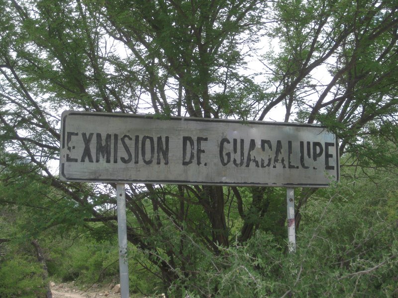
I was at Guadalupe mission twice, 2017 and 2019.
The gate on the first (south) access road (the one at the sign: 'Ex-Misión de Guadalupe') is wired shut. The gate on the next road towards the palms
(mission area) which is just a few feet past the fork going to San José de Magdalena [now washed out] at the sign for La Presa, is not locked... like
other animal control gates...
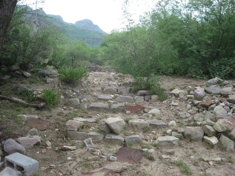
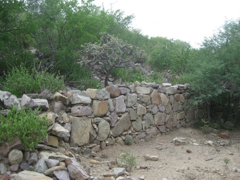
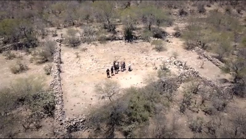
The mission site is extensive with many rock walls, stairways, and foundation stones set in the earth. The mission church itself had some adobe walls
standing from the rock base in a 1998 photo. Now, the adobe is gone, but the rock walls of the church are there, up on the slope of the hill, above
(west of) the modern cinder block building on the pad (at the end of the road with the wired-shut gate.
Stairs leading to the 1720-1795 mission complex:
Inside the mission church:
From a drone, the mission church is the rectangular shape on the right.
|
|
|
| Pages:
1
2 |


