ztrab
Junior Nomad

Posts: 46
Registered: 2-16-2005
Member Is Offline
|
|
cross over from Compadre Trail to Laguna Hanson rd ?
It's been decades since I crossed over, I 've been picking up LH from Rumarosa the last 10 years or so or just ripped through the Compadre when
starting from Tecate. Does anyone has recent tracks or intel on a crossover on the northern reaches that is open? I like going by LH but don't know
what's still open between the two trails.
Going down on my dirt bike the 10th, head south from Tecate the 11th.
Thanks in advance.
Mike
|
|
|
Maderita
Senior Nomad
Posts: 634
Registered: 12-14-2008
Location: San Diego
Member Is Offline
|
|
Hey Mike,
Where do you want to cross to the east?
I frequent Rancho El Topo at least monthly.
Sometimes I go by horseback, Jeep, or dirtbike on the road between there and Ranchos Las Margaritas and Gavilanes. Also ride the main Rumorosa/Laguna
Hanson road between El Topo and the Parque Nacional. Occasionally take the old (pre-1970s) Laguna Hanson road which goes south through El Topo, up a
4x4 rocky trail to a mirador (viewpoint) and then cuts east to intersect the new Laguna Hanson road near the Rancho Sauzalito turnoff.
Not very familiar with the Compadre Trail, but I see dirtbike riders cut over from it to Las Margaritas, and then south past Gavilanes to El Topo.
Some take the old road south through El Topo for the infrequently traveled route in wilderness. Others continue east for 1.5 miles to intersect the
main (newer) Laguna Hanson road at KM 35.2
The gate at El Topo is sometimes locked mid-week until probably mid-April. The ranch is "officially" (wink) closed, but guests are not turned away.
Slow down for the livestock and my burro, and stop at the cafe/guest barn. Ask permission to pass, maybe purchase a cold beer to cut the dust. Beto or
Ricardo will point out the road and wish you a pleasant ride.
Watch the ruts on the Rumorosa/Laguna Hanson road. Tires made deep ruts in the winter mud. Now that it has dried, the hard ruts are out to trip
2-wheeled motos.
Hope this helps. Saludos
|
|
|
ztrab
Junior Nomad
Posts: 46
Registered: 2-16-2005
Member Is Offline
|
|
Thanks. I used to head west just after Rancho Compadre (probably where the trail got iits name, lol). There were several ways to get to the main
Laguna Hanson trail just north of the Park entrance. As I said, I haven't cut beween the trails in probably 20 years and I didn't want to run into
any locked gates or unwelcome ranchers - I respect the ranchers/livestock and have been allowed into many areas when asking for permission. I've
ridden a single track loop between Rumerosa and the Park but that too has been a long time ago. Two years ago, at the T from the LH main road - west
to Ojos or east to Valle Trinidad, the SE cutout to highway 3 was bulldozed to block traffic. On Highway 3 there was an open fence and a sign
indicating Laguna Hason. I figured it might be an Ejido issue or ???, anyway we oftern take the "Goat Trail" anyway but if we were short on time this
was a good cut out to the asphalt to getto VT & Mike's before dark. Passable to motos, but I was still very curious as to what was going on.
Love Baja, very trip is a new adventure.
Saludos and thanks for the info. Mike
|
|
|
bajaric
Senior Nomad
Posts: 605
Registered: 2-2-2015
Member Is Offline
|
|
From Laguna Hanson, it is an easy downhill slide on the main graded dirt road to Hwy. 3 at km 55, bypassing the the goat trail / Santa Catarina route.
I have not driven the Compadre Trail, but 8.6 and 16.2 miles south of El Compadre are roads that go up to Las Margaritas. I would be curious if
either of those two roads would be doable in a 2WD truck but somehow i don't think so.
|
|
|
David K
Honored Nomad
Posts: 64491
Registered: 8-30-2002
Location: San Diego County
Member Is Offline
Mood: Have Baja Fever
|
|
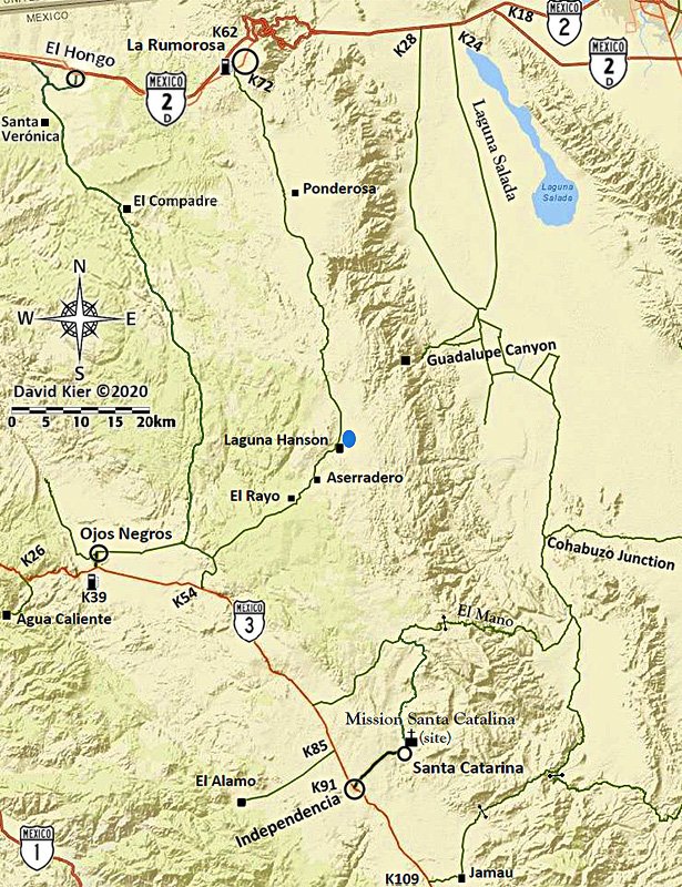
Maps
2009 Baja Almanac
=============================================================
2010 AAA
2021 DK/G
|
|
|
ztrab
Junior Nomad
Posts: 46
Registered: 2-16-2005
Member Is Offline
|
|
Quote: Originally posted by bajaric  | From Laguna Hanson, it is an easy downhill slide on the main graded dirt road to Hwy. 3 at km 55, bypassing the the goat trail / Santa Catarina route.
I have not driven the Compadre Trail, but 8.6 and 16.2 miles south of El Compadre are roads that go up to Las Margaritas. I would be curious if
either of those two roads would be doable in a 2WD truck but somehow i don't think so.
When I did those crossover road circa 2000, they were fro the most part passable with 2wd. There were some fires/floding here and there mid 2000,
can't say after that but it's not so much the terain I am concerned about on my 500 - it locked gates or disgrutled ranchers - it will probably be
just 2 or 3 bikes, The KM 54/55 exit at Highway 3 was the carved up area i ran into in 2019, we rode through it but I was curious what was going on
as that was a well-traveled section. I rode both the Rumarosa/LH trail and the Compadre in Feb 2018 on the 500. I'm staying at Meling Ranch,
probably go through Mike's - Simpson - El Coyote, its a long day. |
|
|
|
ztrab
Junior Nomad
Posts: 46
Registered: 2-16-2005
Member Is Offline
|
|
Thanks David, I have the maps as well and I have ridden from El Condor to the Park, albeit a long tme ago, My Q was about gates, etc.
|
|
|
advrider
Super Nomad
Posts: 1847
Registered: 10-2-2015
Member Is Offline
|
|
I have tracks for both of the routes on David's maps above if that's what you need? Also have one that takes off of HWY 3 and runs into the Compadre
trail near the ranch? I can send a GPX file of each?
|
|
|
ztrab
Junior Nomad
Posts: 46
Registered: 2-16-2005
Member Is Offline
|
|
Thanks, I have tracks for Compadre & Rumorosa LH. If you have track that connect from around El Compadre ranch off the Compadre trail to the
Rumarosa road to LH and know if there are any issues with private land between, ie, locked gates, that is what I am looking for. I've done it but
almost 20 years ago and no GPS and of course thing change. I could slab it to El Condor or Rumarosa from Tecate 2 libre but I's rather pick up
COmpadre to LH an south. I just prefer the Rumarosa to LH trail and yeah, I'll be on itSaturday, so SxS and truck traffic is alway a concern.
If you have a recent connecting
track between the two as described above, that would be great, I'll PM you my email. Gracias amigo
|
|
|
Maderita
Senior Nomad
Posts: 634
Registered: 12-14-2008
Location: San Diego
Member Is Offline
|
|
ztrab,
I don't know exactly what route you are wanting to take from Rancho El Compadre. So I don't know if this information is helpful:
I made a loop approx. 2 years ago. El Topo to Gavilanes to Las Pilitas, then east and southeast toward San Pedro. (I took a shortcut back to El Topo.
A different loop last summer included the section from San Pedro to the Laguna Hanson road.
So if you are going through Las Pilitas, all roads back to the Laguna Hanson road should be open and not gated, as far as I know. I have no info about
the roads between El Compadre and Las Pilitas. Sorry, I don't use GPS tracks, that's cheating, jajaja. I plan to be at El Topo and Canyon Tajo this
Friday through Sunday. Rock climbing, dirtbiking, and horseback riding in this wonderful spring weather.
|
|
|
ehall
Super Nomad
Posts: 1906
Registered: 3-29-2014
Location: Buckeye, Az
Member Is Offline
Mood: It's 5 o'clock somewhere
|
|
Turn left just past compadre ranch. There is a sign with hundreds of stickers. Follow tracks to Laguna hansen.
|
|
|
ztrab
Junior Nomad
Posts: 46
Registered: 2-16-2005
Member Is Offline
|
|
Thanks all. The fella I am riding with did the trail from El Ccmpadre Ranch in Feb 2020 so I have his track and he had no gate issues. I rode for
years without GPS and getting lost , finding new trails, talking to locals was a lot of fun back in the day.
I have a long day to get to Melling's by almost all dirt, so I don't have a lot of daylight to burn - though I do have a killer Baja Designs
headhlight - it has bailed me out many times.
Saludos
|
|
|
Maderita
Senior Nomad
Posts: 634
Registered: 12-14-2008
Location: San Diego
Member Is Offline
|
|
This update was just reported by Rancho Alamar. If going from Laguna Hanson to Highway 3, or the reverse, be advised:
"Buen día...
Aviso, sigue cerrado el acceso a Laguna Hanson por el Km 54. Tomen sus precauciones.
Vía alterna Poblado de Ojos Negros o Km 45"
 aplikasi cek keyboard laptop aplikasi cek keyboard laptop
|
|
|
David K
Honored Nomad
Posts: 64491
Registered: 8-30-2002
Location: San Diego County
Member Is Offline
Mood: Have Baja Fever
|
|
| Quote: Originally posted by Maderita | This update was just reported by Rancho Alamar. If going from Laguna Hanson to Highway 3, or the reverse, be advised:
"Buen día...
Aviso, sigue cerrado el acceso a Laguna Hanson por el Km 54. Tomen sus precauciones.
Vía alterna Poblado de Ojos Negros o Km 45"
|
For the non-Spanish readers:
"Good day...
Warning, the access to Laguna Hanson is still closed at Km 54. Take your precautions.
Alternative route: Ojos Negros or Km 45"
|
|
|
ztrab
Junior Nomad
Posts: 46
Registered: 2-16-2005
Member Is Offline
|
|
There was no closed gate at KM54/55 when I exited the 10 days ago
|
|
|
David K
Honored Nomad
Posts: 64491
Registered: 8-30-2002
Location: San Diego County
Member Is Offline
Mood: Have Baja Fever
|
|
Thanks!
That is the main signed road to the park and Sierra Juarez, after all.
The Baja Nomad Kilometer List (on the Nomad Road Conditions forum):
HWY 3 (Ensenada to San Felipe):
KM 9.5 Horsepower Ranch entrance road.
KM 19 Access to the Wall on race course.
KM 26 Access to Agua Caliente Hot Springs, south.
KM 33 SCORE race course return route.
KM 39 Pemex Gas Station, Military Checkpoint
KM 39.5 Ojos Negros turn off, north.
KM 54.5 Road north to Laguna Hanson (20 mi) and La Rumorosa (58 mi)
KM 85.5 Road west to El Alamo (9 mi).
KM 91+ Heroes de la Independencia, at road east to Santa Catarina, 5 miles, concrete road. Mission Santa Catalina site is 5.4 miles.
KM 109 Ejido Jamau Road east (5 mi)
KM 117.5 'Goat Trail'.
KM 120+ Valle de Trinidad. Pemex.
KM 130+ Children Orphanage 'El Oasis', Malcolm Smith supports it.
KM 137.5 Mike Sky Rancho access (20 mi.).
KM 141 San Matias village
KM 151 Access to Diablo Dry Lake, in arroyo.
KM 152.5 Access to Arroyo Grande.
KM 162.5 & 163 Access to Diablo Dry Lake by graded road.
KM 173 Access to Borrego pit area.
KM 179.5 Borrego crossing for races.
KM 195 Military Checkpoint
KM 196 Jct with Hwy 5 at KM140.5.
|
|
|
PaulW
Ultra Nomad
Posts: 3009
Registered: 5-21-2013
Member Is Offline
|
|
Not going to add Km45?
Of course KM45 is definitely wrong anyway.
BTW, Km55 is much closer to the turn than 54.5
I would say 54.8+ is pretty correct.
[Edited on 4-22-2021 by PaulW]
|
|
|
David K
Honored Nomad
Posts: 64491
Registered: 8-30-2002
Location: San Diego County
Member Is Offline
Mood: Have Baja Fever
|
|
The .5 here means between the two and out of sight of either.
I suppose you could check on Street View GE?
I just looked at my notes and I didn't modify the .5 wit a + as I do it it was closer to the next whole numbers... I think between that and the signs
advertising the road, it can't be missed...!?
|
|
|


