| Pages:
1
2 |
geoffff
Senior Nomad

Posts: 643
Registered: 1-15-2009
Member Is Offline
|
|
Where were these photos taken?
I want to play this game too! Wanna show your Baja expertise by identifying where I took these photos?
(Yeah, I've shared all these images before - so no fair reading through the 100s of photos I've posted on Baja Nomad over the years.)
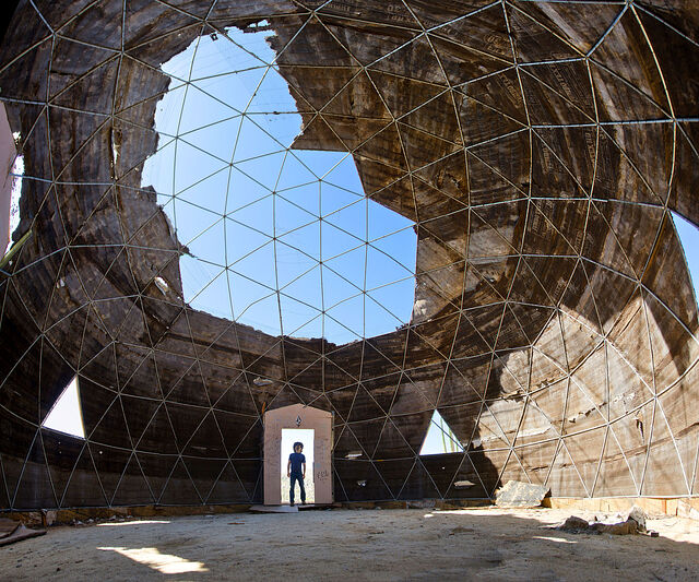
Photo #1: El Palmerito dome ruin, Catavina
29.755,-114.7474
identified by willardguy

Photo #2: Gavilan manganese mine
26.8794,-111.7967
identified by davidk
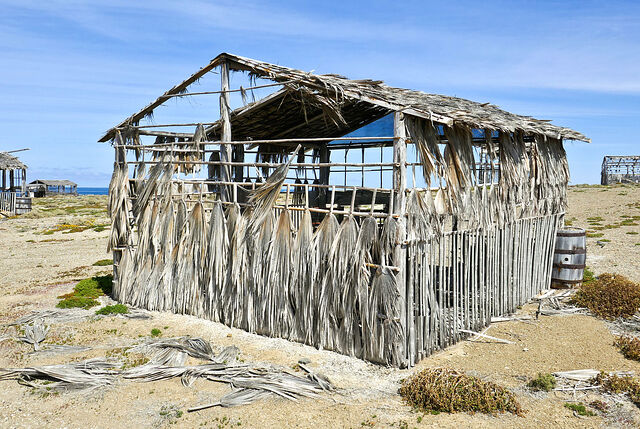
Photo #3: Punta Falsa ruins, near Punta Eugenia
27.8608,-115.0557
identified by willardguy
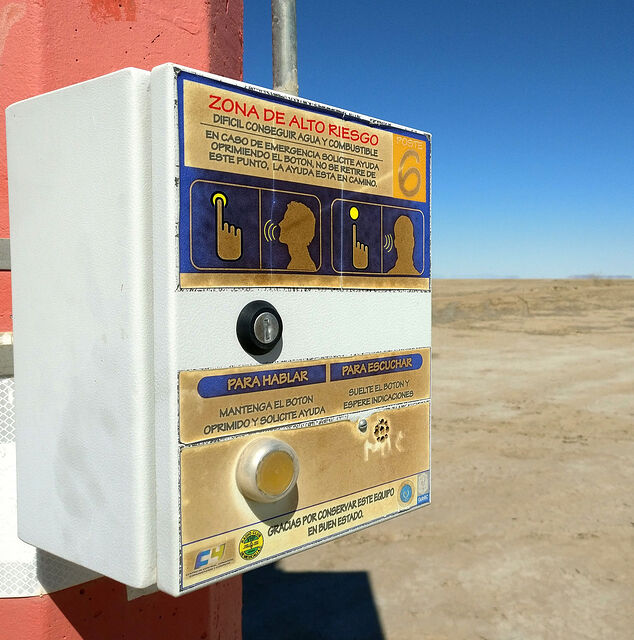
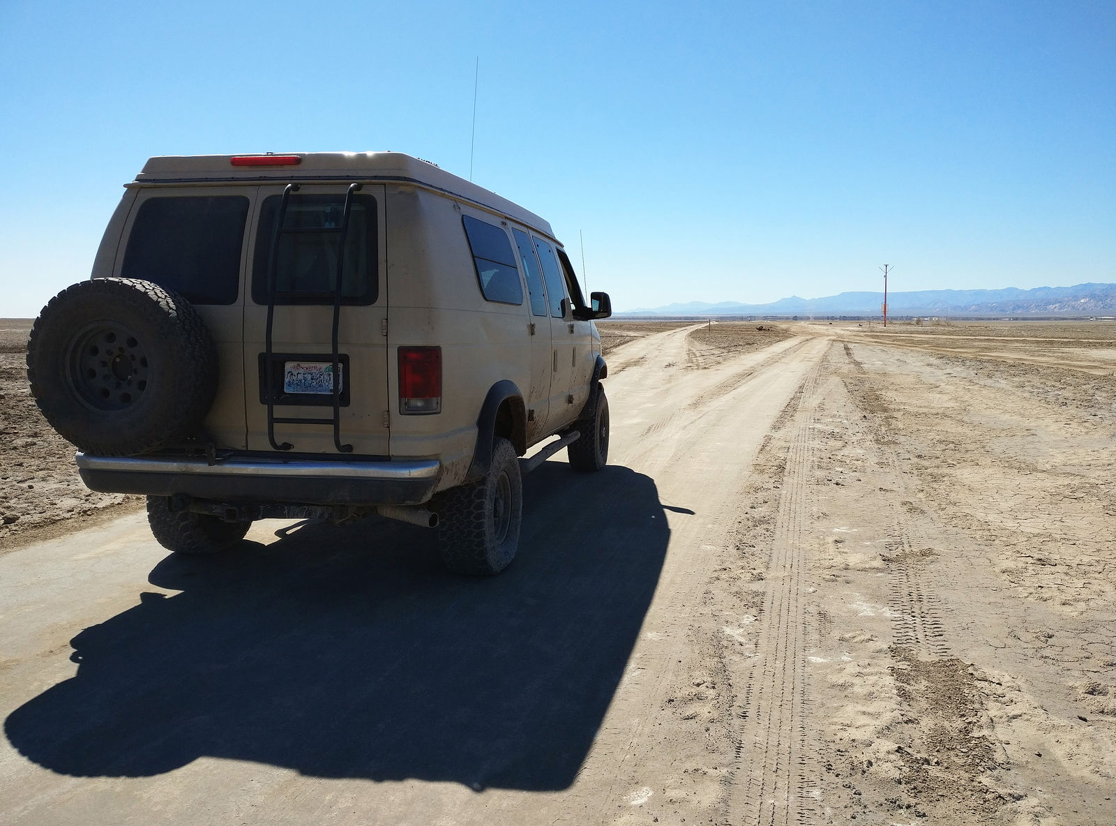
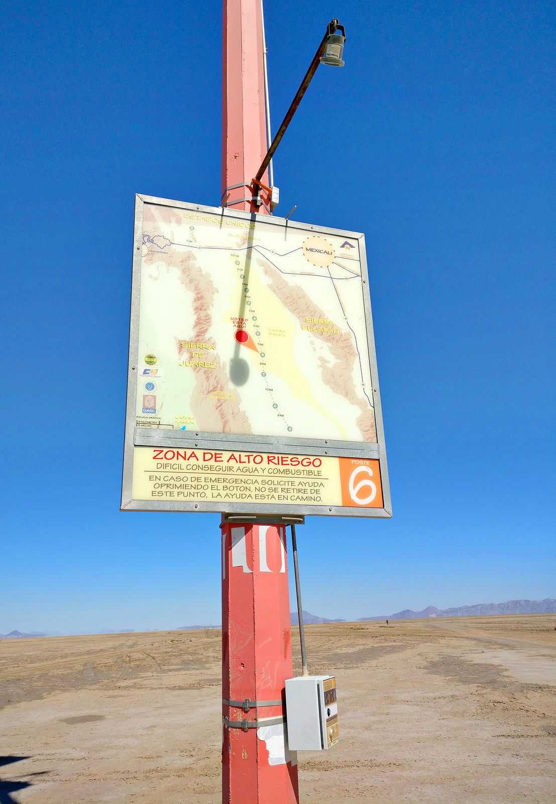
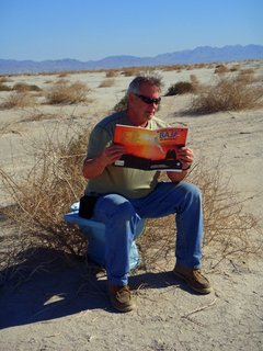
Photo #4: Laguna Salada emergency beacon #6
32.2639,-115.6661
identified by Maderita

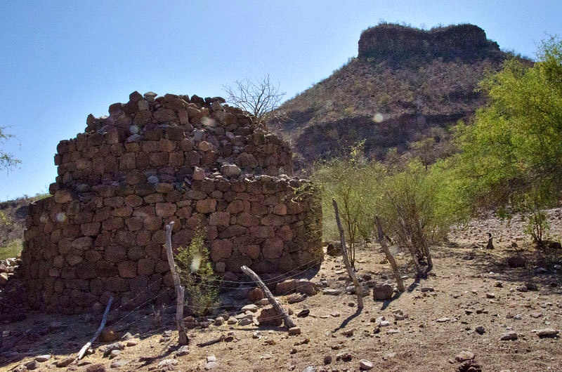
Photo #5: Rancho Araugo ruins (Santa Isabel canyon)
31.9079,-115.6723
identified by 4x4abc

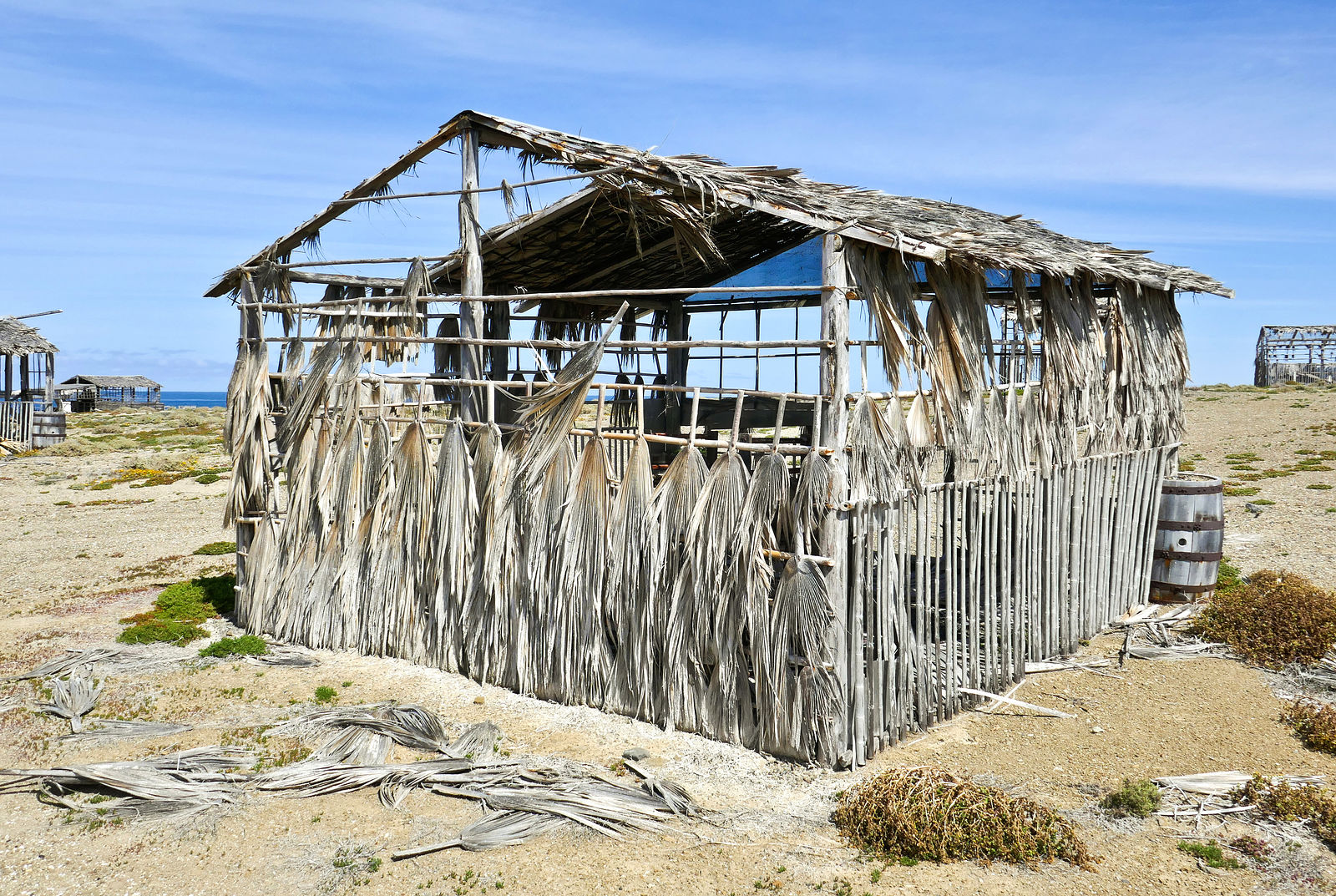
Photo #6: Los Pinos abandoned RV park, at the south end of Bahia Concepcion
26.5374,-111.7363
identified by Don Pisto, davidk, 4x4abc

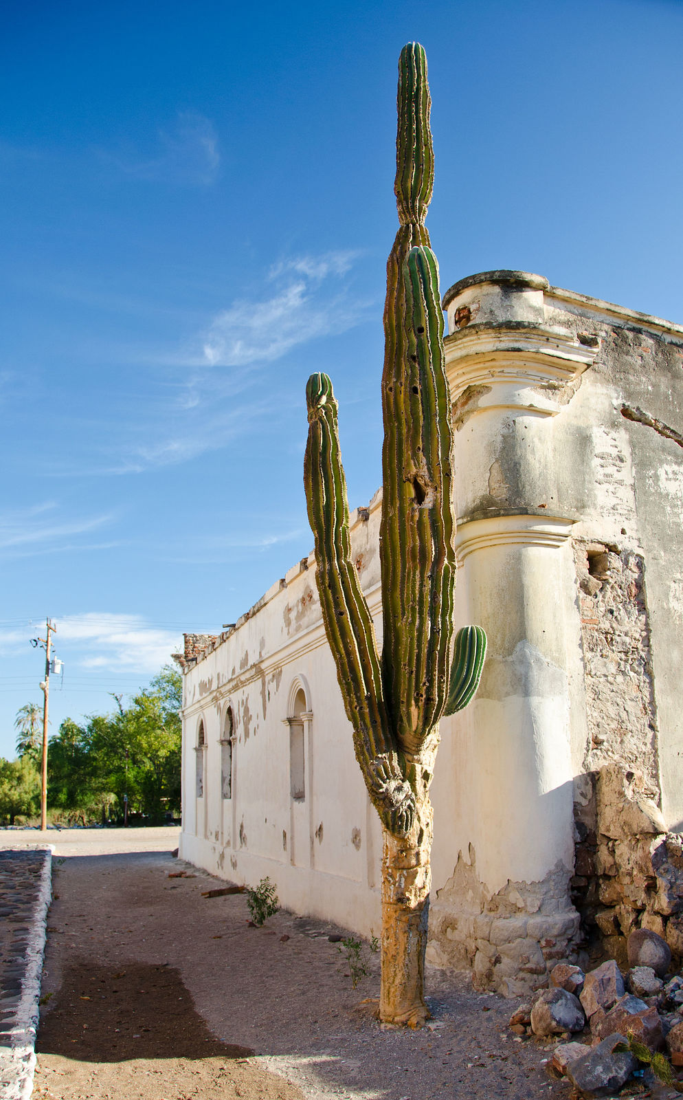
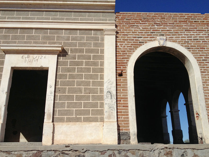
Photo #7: building next to (east of) mission San Luis Gonzaga, looking north
24.9079,-111.2908
identified by Don Pisto
Photo #8: driving south approaching San Juan de la Costa - mining road and public road
24.4085,-110.6930
identified by willardguy

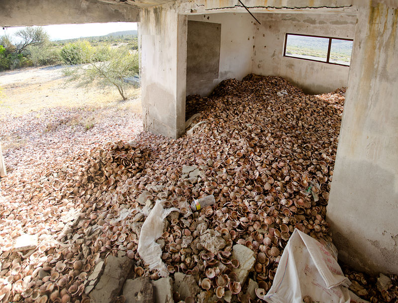
Photo #9 "sweet location": San Marcos Tierra sugar mill ruins, Estero San Marcos
27.1137,-112.0705
identified by davidk, 4x4abc
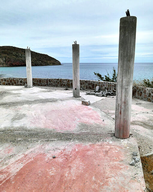
Photo #10: Abandoned beach houses, Ensenada el Mangle.
26.2776,-111.3947
identified by CJ
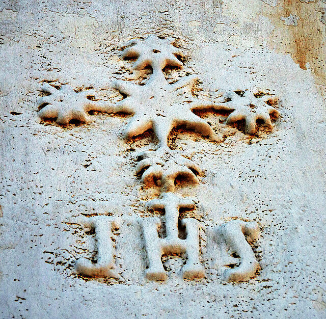
Photo #11: detail on front of mission, San Luis Gonzaga
24.9082,-111.2909
identified by Don Pisto

Photo #12: La Casona, Prosperidad
27.8218,-113.2349
identified by davidk
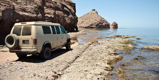
Photo #13 "getting warmer": the "road" to San Cosme hot spring
25.5816,-111.1696
identified by davidk

Photo #14: El Horno, on road between San Jose Comondu and San Javier
25.9965,-111.7104
identified by davidk
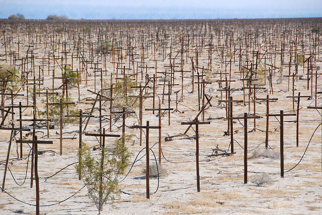
Photo #15: abandoned vinyard, Laguna Salada. INEGI map says "Almacen de Deposito"
32.1327,-115.6353
identified by davidk
[Edited on 5-7-2021 by geoffff]
|
|
|
willardguy
Elite Nomad
Posts: 6451
Registered: 9-19-2009
Member Is Offline
|
|
first one is whats left of my buddy's geo dome El Palmerito in Catavina #3 is punta Eugenia, laguna Ojo de libra is #6, #8 going out to san juan de la
costa?
[Edited on 5-6-2021 by willardguy]
|
|
|
Maderita
Senior Nomad
Posts: 634
Registered: 12-14-2008
Location: San Diego
Member Is Offline
|
|
#4 = On the dry lakebed at the southern end of Laguna Salada. En route to Canyon Guadalupe. The 6th emergency beacon is just a few miles north of
Ejido Manatou and the abandoned olive grove. Guessing approximately east of Canyon Carrizo.
But perhaps I should consult my Baja Almanac at the infamous blue toilet of Laguna Salada:
|
|
|
David K
Honored Nomad
Posts: 64476
Registered: 8-30-2002
Location: San Diego County
Member Is Offline
Mood: Have Baja Fever
|
|
I like your photo choices, geoffff!
I know or am pretty sure about #1, 2, 3, 4, 7, 8, 12, 13, 14
Let me take a guess at #15: Laguna Salada valley, an abandoned grape vineyard project?
Funny clue on #13, by-the-way!
#11... OK! LOL
|
|
|
Don Pisto
Super Nomad
Posts: 1228
Registered: 8-1-2018
Location: El Pescador
Member Is Offline
Mood: weary like everyone else
|
|
7,11,12 are san luis gonzaga...we're pretty sure JHS means jefferson high school 
there's only two things in life but I forget what they are........
John Hiatt
|
|
|
geoffff
Senior Nomad
Posts: 643
Registered: 1-15-2009
Member Is Offline
|
|
In my head I keep reading it as "Jesus H. chriSt"
|
|
|
AKgringo
Elite Nomad
Posts: 5805
Registered: 9-20-2014
Location: Anchorage, AK (no mas!)
Member Is Offline
Mood: Retireded
|
|
I found the masonry structures in #5 just last year while exploring side roads on the Cortez side. For the life of me, I can't remember where I was
at the time!
There were other partial structures which made it appear that it was a project that was never finished.
If you are not living on the edge, you are taking up too much space!
"Could do better if he tried!" Report card comments from most of my grade school teachers. Sadly, still true!
|
|
|
David K
Honored Nomad
Posts: 64476
Registered: 8-30-2002
Location: San Diego County
Member Is Offline
Mood: Have Baja Fever
|
|
I think #12 looks more like this place than San Luis Gonzaga???:

|
|
|
CJ
Nomad
Posts: 204
Registered: 8-29-2003
Location: Loreto, B.C.S. y Lopez Mateos
Member Is Offline
Mood: It's cool with me
|
|
#10 abandoned Canadian compound @ Punta Mangles north of Loreto
|
|
|
geoffff
Senior Nomad
Posts: 643
Registered: 1-15-2009
Member Is Offline
|
|
I may update the original post with answers later, but here is what we have so far:
willardguy: "first one is whats left of my buddy's geo dome El Palmerito in Catavina" [Yup! GPS: 29.7549,-114.7474]
willardguy: "#3 is punta Eugenia" [Yes! Or, more specifically, Punta Falsa - a couple miles NE of there. GPS:
27.8608,-115.0557]
Maderita: "#4 = On the dry lakebed at the southern end of Laguna Salada. En route to Canyon Guadalupe. The 6th emergency
beacon is just a few miles north of Ejido Manatou and the abandoned olive grove. Guessing approximately east of Canyon Carrizo. " [yup!
32.2639,-115.6661]
[AKgringo, maybe! Anyone else want to chime in here?]
[willardguy, nope!]
Don Pisto: 7,11,12 are san luis gonzaga [7,11: yes! the old building just east of the Mission, GPS:
24.9079,-111.2907]
willardguy: "#8 going out to san juan de la costa?" [Yup! Looking south. Can see the SJdlC pier in the distance. On the
right is the nice mining road, and on the left is the road the public must use. GPS:24.4085,-110.6930]
CJ: "#10 abandoned Canadian compound @ Punta Mangles north of Loreto" [yes! GPS: 26.2776,-111.3947]
Don Pisto: 7,11,12 are san luis gonzaga [7,11: yes, "Jefferson High School" 24.9082,-111.2909]
[Don Pisto, nope! DavidK, yes! Anyone else want to name the place?]
davidk: "#15: Laguna Salada valley, an abandoned grape vineyard project?" [yup! GPS: 32.1327,-115.6353]
|
|
|
David K
Honored Nomad
Posts: 64476
Registered: 8-30-2002
Location: San Diego County
Member Is Offline
Mood: Have Baja Fever
|
|
#2, the (Gavilanes) Manganese Mine near Punta Concepción.
#13, the 'road' to the San Cosme (Agua Verde) tidal hot springs.
#14, El Horno (between San Javier and San José Comondú.
|
|
|
geoffff
Senior Nomad
Posts: 643
Registered: 1-15-2009
Member Is Offline
|
|
Quote: Originally posted by David K  | #2, the (Gavilanes) Manganese Mine near Punta Concepción.
#13, the 'road' to the San Cosme (Agua Verde) tidal hot springs.
#14, El Horno (between San Javier and San José Comondú. |
Nice!!!
|
|
|
geoffff
Senior Nomad
Posts: 643
Registered: 1-15-2009
Member Is Offline
|
|
Still looking for #5, #6, and #9
|
|
|
geoffff
Senior Nomad
Posts: 643
Registered: 1-15-2009
Member Is Offline
|
|
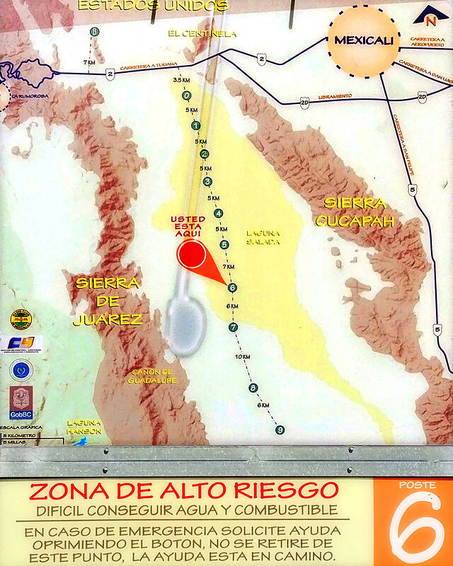
I was surprised by this super-helpful emergency cache of water and radio contact out there in the desert. Pretty fancy!!! I suspect there is a good
story behind this elaborate system -- maybe some people died out there in the desert(?)
Looking closely, it says "Radio Club VHF de Mexicali". Facebook says the Radio Club installed it, and it saved 27 lives in September, 2011. Thanks, guys!!!

It includes a helpful map:
   
[Edited on 5-6-2021 by geoffff]
|
|
|
David K
Honored Nomad
Posts: 64476
Registered: 8-30-2002
Location: San Diego County
Member Is Offline
Mood: Have Baja Fever
|
|
Yes, too many Mexicali and other citizens thought their 2WD Chevys and Nissans could go anywhere! There was a post about these beacons many years ago.
|
|
|
pjpvi
Nomad
Posts: 110
Registered: 2-17-2019
Member Is Offline
|
|
#6 Calamajue????
|
|
|
4x4abc
Ultra Nomad
Posts: 4163
Registered: 4-24-2009
Location: La Paz, BCS
Member Is Offline
Mood: happy - always
|
|
https://www.washingtonpost.com/archive/politics/1996/08/03/1...
Harald Pietschmann
|
|
|
4x4abc
Ultra Nomad
Posts: 4163
Registered: 4-24-2009
Location: La Paz, BCS
Member Is Offline
Mood: happy - always
|
|
#6, Rancho Araugo 31°54'27.57"N, 115°40'22.41"W
Harald Pietschmann
|
|
|
willardguy
Elite Nomad
Posts: 6451
Registered: 9-19-2009
Member Is Offline
|
|
In their final, desperate moments in the 120-degree desert heat, some of the lost soldiers of the Mexican army's 18th Mechanized Calvary Regiment
stripped naked, ripping off even the metal dog tags that had begun to scorch their flesh.
I guess in this case the mis-spelling wasn't too far off 
|
|
|
geoffff
Senior Nomad
Posts: 643
Registered: 1-15-2009
Member Is Offline
|
|
Yes!!! That's actually my photo #5 (my text went below photos not above)
I was told recently by a source who seems to know what he's talking about that the rancho is the ruins of a resort built by former Baja Governor
Xicoténcatl Leyva Mortera before he got into trouble for some corruption scandal - after which the ranch was seized by the federal govt.
|
|
|
| Pages:
1
2 |