| Pages:
1
2
3
4 |
PaulW
Ultra Nomad

Posts: 3005
Registered: 5-21-2013
Member Is Offline
|
|
Thanks for more of your images.
Now I correctly understand the errors of both the Alamac and Atlas.
My image of the roads on GE ends any dispute of the errors.
Conclusion regarding Atlas/Almanac:
Roads are shifted or incorrectly plotted. Roads do not go over mountains or hills.
Chale is not plotted correctly or labeled correctly
Besides I do not think Chale even exists now days as depicted on INEGI. See GE which is a later image.
Maybe some cartographer decided to call Parral as Chale when the path gets close to the sea? Maybe locals used the name Chale instead of Parral for
unknown reasons?
Next season I will go and drive the disputed area. I do expect more confusion due to the date of both GE and INEGI we are all using.
Meanwhile if anyone wants to go and drive the roads use the attached GPS file
Attachment: Chale Question.gpx (168kB)
This file has been downloaded 125 times
|
|
|
David K
Honored Nomad
Posts: 64480
Registered: 8-30-2002
Location: San Diego County
Member Is Offline
Mood: Have Baja Fever
|
|
Paul, my PC won't open a GPX file, can you do a KMZ?
|
|
|
geoffff
Senior Nomad
Posts: 643
Registered: 1-15-2009
Member Is Offline
|
|
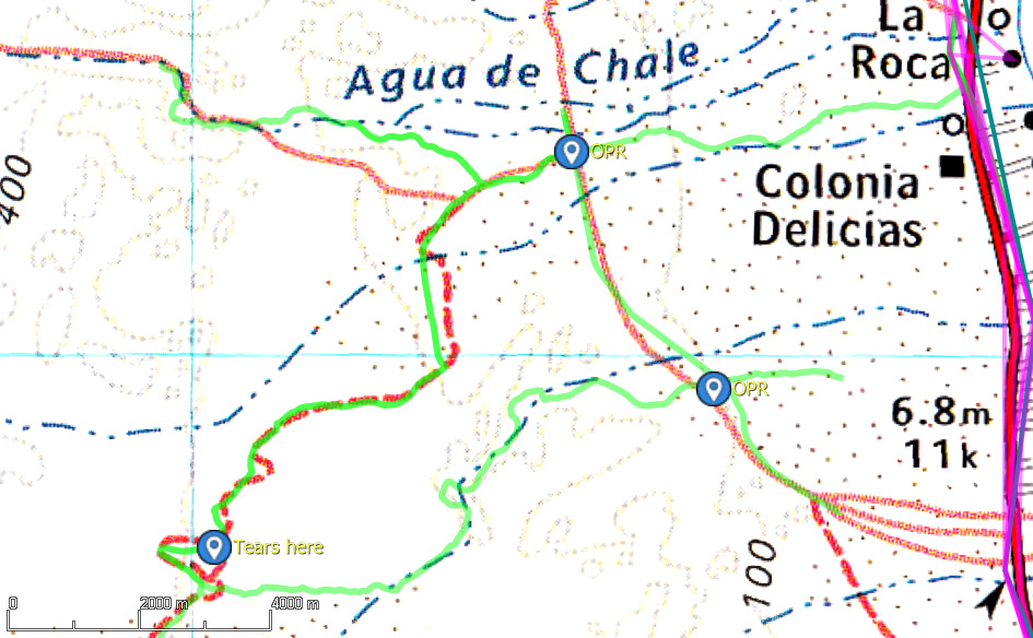
Thanks! Here's PaulW's track plotted:
Benchmark / Baja Almanac /
INEGI / satellite
|
|
|
David K
Honored Nomad
Posts: 64480
Registered: 8-30-2002
Location: San Diego County
Member Is Offline
Mood: Have Baja Fever
|
|
Can you trace the arroyo from the coast at Nuevo Mazatlan back west? That is Arroyo Agua de Chale. I think we can see that the one coming out of
Parral Canyon does not wander north to Nuevo Mazatlan.
This kind of study will help make the next edition of the Atlas better. We have friends at Benchmark Maps who want to customize maps for more
accuracy!
All maps have errors, some are even intentional for copyright protection. I found a mistake last night in the Atlas, that Benchmark made (the years
the final Comondú mission was open). Stuff happens.
|
|
|
geoffff
Senior Nomad
Posts: 643
Registered: 1-15-2009
Member Is Offline
|
|
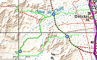
Here is PaulW's track as a Google Earth file: chale.kml
[Edited on 5-24-2021 by geoffff]
|
|
|
geoffff
Senior Nomad
Posts: 643
Registered: 1-15-2009
Member Is Offline
|
|
Exactly -- your posting earlier about intentional map errors is what made me think it was curious that Benchmark had seemingly replicated Baja
Almanac's "error" here.
|
|
|
PaulW
Ultra Nomad
Posts: 3005
Registered: 5-21-2013
Member Is Offline
|
|
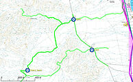
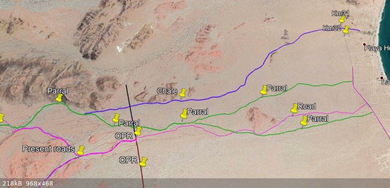
More with possible Parral water flow paths.
As you can see on Google earth Parral spreads out widely when the terrain gets flatter.
Looking a the kml you all can make your own paths.
BTW, I have noticed over the years the roads usually follow the main drainage. However this area is pretty drivable any place.
Attachment: Chale QuestionR.gpx (209kB)
This file has been downloaded 112 times
Attachment: Chale QuestionR.kml (90kB)
This file has been downloaded 101 times
|
|
|
David K
Honored Nomad
Posts: 64480
Registered: 8-30-2002
Location: San Diego County
Member Is Offline
Mood: Have Baja Fever
|
|
Is the dark blue (or is that a purple?) line with the Chale pushpin, the arroyo or a road? If the arroyo, then it does go to Nuevo Mazatlan. What are
the red (or green?) lines marked Parral; arroyos or roads?
Sorry for my 'color-challenged' eyes. They do not see reds and greens well to tell them apart. Purple is red + blue, so that is why I am not sure if
it is purple or a shade of blue.
|
|
|
PaulW
Ultra Nomad
Posts: 3005
Registered: 5-21-2013
Member Is Offline
|
|
Sorry about the colors
Legend:
Green is my guess for Parral
dark blue is Chale
Purple is roads
Top is blue Chale water path.
Next one down is green represents possible Parral water path
Third one down by Hwy 5 is purple like Hwy 5 and designates roads
Bottom is green and crosses the road
On the KML change the color to suit. If you can see a faint line right click on it choose properties then choose a color and click OK. No color also
works and some like that because it shows up on a dark background.
|
|
|
PaulW
Ultra Nomad
Posts: 3005
Registered: 5-21-2013
Member Is Offline
|
|
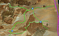
Chale
One more time
Both the Almanac and Atlas show the entrance to Parral incorrectly.
Compare the Google earth and OZI Explorer images.
IMO if Arroyo Chale is to be shown on the map it must be moved south to where the images how the water is now flowing.
Of course it would be wise to do a ground check to validate the satellite images.
1) My opinion is Chale should not be shown at all because it located wrong.
2) Or be replaced by Parral at the location shown at K 34.6. Maybe Call it Parral/Chale?
K34 = 30 42.229, -114 42.842
k34.6+ WP Chale = 30 41.900, -114 42.679
k35 = 30 41.722, -114 42.679
View the KML and see what you all think.
Google
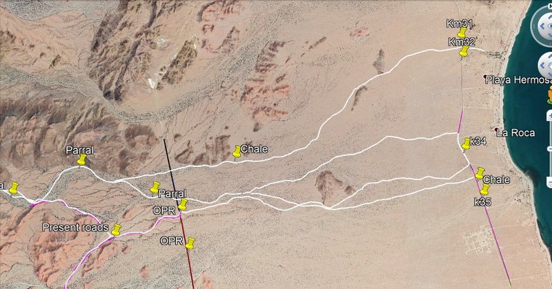
Ozi

Attachment: Latest.kml (119kB)
This file has been downloaded 115 times
[Edited on 5-27-2021 by PaulW]
|
|
|
David K
Honored Nomad
Posts: 64480
Registered: 8-30-2002
Location: San Diego County
Member Is Offline
Mood: Have Baja Fever
|
|
Thank you Paul!!  
|
|
|
PaulW
Ultra Nomad
Posts: 3005
Registered: 5-21-2013
Member Is Offline
|
|
Quote: Originally posted by geoffff  | I purchased the Avenza digital version, and am already playing with it. There's Shell Island!
=== ===
Tell us about the digital version.
Any pros or cons?
Is it as good as INEGI regarding zooming with preserved detail? |
|
|
|
geoffff
Senior Nomad
Posts: 643
Registered: 1-15-2009
Member Is Offline
|
|
| Quote: Originally posted by PaulW |
Tell us about the digital version.
Any pros or cons?
Is it as good as INEGI regarding zooming with preserved detail? |
The Avenza digital maps are just very good scans of the paper Benchmark atlas - so you can't zoom in past the book's maximum resolution. All the
Benchmark map images I've been posting here on the BN over the last week or so are taken from the Avenza images (I don't have the paper book yet). So,
no they don't really replace INEGI -- but they are much more pleasant to look at a when you are few steps zoomed out.
(The periodic image jitter you see above in the Benchmark images is my fault, caused by my image capture process.)
[Edited on 5-28-2021 by geoffff]
|
|
|
geoffff
Senior Nomad
Posts: 643
Registered: 1-15-2009
Member Is Offline
|
|
It's a bit of a shame that Avenza didn't (seemingly) get access to the raw digital images from Benchmark instead of scanning the printed book. Then
the Avenza maps could look sharper - even if they didn't actually show more detail. But it's not a big deal.
|
|
|
David K
Honored Nomad
Posts: 64480
Registered: 8-30-2002
Location: San Diego County
Member Is Offline
Mood: Have Baja Fever
|
|
Just to clarify, Avenza download is one single map of the peninsula, not separate pages with page breaks or staple binding, as is the book. You can
zoom way in with crystal clarity and that I enjoy better than the book version, which requires reading glasses or a magnifying glass for old me.
The Avenza version is only the landscape map. The book has additional recreation maps, state maps, and specialty close-up maps of Los Cabos, La Paz,
and Guadalupe Valley along with all the recreational text and photographs (they used two of my photos in that part).
|
|
|
PaulW
Ultra Nomad
Posts: 3005
Registered: 5-21-2013
Member Is Offline
|
|
Thanks
I have the book.
Your incite is greatly appreciated.
Yup, hard to read so my magnifier is close at hand. If no real digital is forthcoming I will need a bigger magnifier.
I am looking forward to a Benchmark digital version that equals the INEGI for zooming.
I wonder if that is a possibility?
And how long I have to wait?
|
|
|
David K
Honored Nomad
Posts: 64480
Registered: 8-30-2002
Location: San Diego County
Member Is Offline
Mood: Have Baja Fever
|
|
Send them an email! All the feedback will help Taylor the product. Bridger is the head guy for this book and Neil is the lead cartographer.
|
|
|
PaulW
Ultra Nomad
Posts: 3005
Registered: 5-21-2013
Member Is Offline
|
|
PM me a email and I will do it.
|
|
|
geoffff
Senior Nomad
Posts: 643
Registered: 1-15-2009
Member Is Offline
|
|
| Quote: Originally posted by David K | | Just to clarify, Avenza download is one single map of the peninsula, not separate pages with page breaks or staple binding, as is the book.
|
Yes! Having done that myself with my copy of the Baja Alamanc, I know it's a lot of work. I appreciate Avenza for doing this.
| Quote: Originally posted by David K | | The Avenza version is only the landscape map. The book has additional recreation maps, state maps, and specialty close-up maps of Los Cabos, La Paz,
and Guadalupe Valley along with all the recreational text and photographs (they used two of my photos in that part). |
Cool! Can't wait to get a paper copy!
|
|
|
David K
Honored Nomad
Posts: 64480
Registered: 8-30-2002
Location: San Diego County
Member Is Offline
Mood: Have Baja Fever
|
|
A second printing will answer the demand. A 48" wall map is also coming, yea!
|
|
|
| Pages:
1
2
3
4 |