otis
Newbie
Posts: 5
Registered: 5-17-2021
Member Is Offline
|
|
Scorpion Bay North Road
Hey all,
Trying to get any recent reports from the north road into San Juanico/Scorpion Bay. Heading down in June and wondering if it's worth it to go for the
north road or just play it safe and take the long way south.
Any reports or thoughts on making the trip in mid June would be greatly appreciated. Will have 4wd but not a ton of offroad experience so would rather
not get ourselves in too deep.
Thanks!
|
|
|
RFClark
Super Nomad

Posts: 2470
Registered: 8-27-2015
Member Is Offline
Mood: Delighted with 2024 and looking forward to 2025
|
|
The quote is from scorpionbay.net contact them directly for the latest information We drove about half way there a couple years ago high centering
was our major issue.
“THE NORTH ROAD, leave the highway and cross the river at San Ignacio. But think twice before you take the turn-off from San Ignacio, especially if
you’re not caravanning with another vehicle. Drive through town to the plaza and connect with the road leading south to La Fridera Fish Camp on the
shore of San Ignacio Lagoon. This road is paved for the first 8 to 10 miles. Go left at the Fish Camp. Do not use Google Maps. Download the App
maps.me and then download the Mexico, Baja California Sur map in the App. The internal GPS of your smart device will track your location as you
proceed even without a connection to the web.
Bear left at forks in the road and encounter the moon dust; rocks and ruts obscured beneath deep powder-fine dust, a swirling blizzard of choking grit
that fills your windshield with a yellow haze. Traverse steep arroyos, some with mud and flowing water.and proceed to Cuarenta, San Jose de Gracia,
Raymundo, Cadajé and on into San Juanico.
Bear to the right and leave the graded road to drive on the salt flats via El Datil, Ballena, Cadejé and San Juanico. Risk breaking through the soft
crust to the slick muck below. Do not drive off the tracks. You will see the divots where vehicles left the tracks and were stuck. Again, do not leave
the tracks. The salt flats are smooth. One can easily drive 50 or 60 MPH.
The North Road route is a total of 650 miles (105 miles from San Ignacio, mostly on dirt) from Tijuana. Caravan with another traveler. Take a
shovel, some plywood, a tow chain, a good map and a GPS. Take shortwave radios, extra fuel, water, and fully inflated spare tires. Take notes, it will
be interesting.”
|
|
|
pacificobob
Super Nomad
Posts: 2357
Registered: 4-23-2006
Member Is Offline
|
|
i have done it on motorbikes 5 or 6 times. there are multiple roads,routes, and many ways to get on tracks that are perhaps not what you want to get
in to.
deep dust, and sand can become a problem you might not enjoy much.
if you're seeking a way to try out your recovery gear and skills this could perfect. bring lots of water.
|
|
|
Mulege Canuck
Nomad
Posts: 393
Registered: 11-27-2016
Member Is Offline
|
|
Quote: Originally posted by otis  | Hey all,
Trying to get any recent reports from the north road into San Juanico/Scorpion Bay. Heading down in June and wondering if it's worth it to go for the
north road or just play it safe and take the long way south.
Any reports or thoughts on making the trip in mid June would be greatly appreciated. Will have 4wd but not a ton of offroad experience so would rather
not get ourselves in too deep.
Thanks! |
I did that road last year in my F350 and truck camper. As long as you stay on the right route, it is not that bad, but if you get off track life can
get sheety quickly.
Plot your route ahead of time on a GPS. I use an App called Navionics, and stay on the most travelled route.
If you have not done a lot of “booney bashing” I would not recommend it. Maybe on your way home go back that way with an experienced person who
has done it before.

|
|
|
Cancamo
Nomad
Posts: 364
Registered: 4-5-2011
Member Is Offline
|
|
I prefer it to the transpeninsular, (no traffic, good camping), I try to spend the night out there taking the high road and closing gates behind you.
Few bad spots on the drainages, other than that a normal road for where I live.
Traveled it last a year ago, never the need to lock in, easy/peasy. No GPS, just fallow the road most traveled, as usual.
|
|
|
pacificobob
Super Nomad
Posts: 2357
Registered: 4-23-2006
Member Is Offline
|
|
yup, the more traveled route is the key phrase. all that is needed is to take the correct path when the road forks.
|
|
|
AKgringo
Elite Nomad
Posts: 6325
Registered: 9-20-2014
Location: Anchorage, AK (no mas!)
Member Is Offline
Mood: Retireded
|
|
The first time I drove the low road, it was difficult to tell the the main road from the most recent tracks. A stiff onshore wind, plus a high tide
had obscured a lot of the options with drifted sand, and storm surge.
I was following Score race course markers, but still got sucked into making a water crossing at the wrong spot by following the "most recent" tracks!
Fortunately I got stuck in sand instead of mud, and was able to get myself out with what I had on board.
I wasn't the only one stuck. I wound up helping a produce truck from Vizcaino get back on the road to EL Datil, and that guy was familiar with the
roads!
If you are not living on the edge, you are taking up too much space!
"Could do better if he tried!" Report card comments from most of my grade school teachers. Sadly, still true!
|
|
|
otis
Newbie
Posts: 5
Registered: 5-17-2021
Member Is Offline
|
|
thanks for all the feedback. will definitely take into consideration before we make the call.
|
|
|
PaulW
Ultra Nomad
Posts: 3113
Registered: 5-21-2013
Member Is Offline
|
|
Sigh - no tracks
|
|
|
David K
Honored Nomad
Posts: 65480
Registered: 8-30-2002
Location: San Diego County
Member Is Offline
Mood: Have Baja Fever
|
|
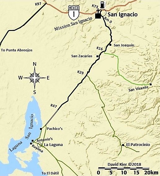
Aug. 2017 road log: San Ignacio to San Juanico, 107.7 miles
Setting the odometer to zero in front of the mission, I head for Laguna San Ignacio, a popular whale watching location, in season. Closed-up to
tourism off season.
The road has been paved to about 5 miles from the lagoon shoreline.
ROAD LOG
The mission and town plaza is 1.6 miles from Highway 1. Continue straight, passing in front of the mission church, passing the market and hotel La
Huerta, the paved street curves left, passing the Hotel Posada. Pavement ends briefly.
Km. 0 This marker sign is 0.6 mi (1 km.) from the mission/plaza. Pavement begins in 500 feet.
Km. 9 Rancho El Batequi
Km. 12.5+ Rancho San Joaquín
Km. 16.5 Road left, signed to San Vicente.
Km. 19.5 San Zacarias
Km. 29.5 Road left to El Patrocinio (35 kms.)
Km. 47.5+ End of Pavement (30.1 miles from the mission/plaza). The road ahead is an elevated roadbed, over the salt pan.
The following are mileages from the mission/plaza in San Ignacio:
34.7 Bypass road south, avoids whale camps and village. Signed San José de Gracia. Log goes on right branch, to the lagoon.
36.1 Pachico’s whale camp entrance, on right.
36.2 Lagoon shore.
38.8 Fork, keep right. Left goes into village.
40.2 Crossroad. Antonio’s Camp is to the right, Kuyima Camp is 0.4 mi ahead. Turn left (east) to continue south. Operations open during whale
watching season. Typically, that is December-April.
40.9 La Laguna village, pass through to far side. Several optional roads come back together.
42.8 Join graded bypass road from Mile 34.7, above.
46.7/ 0.0 Major Fork. Small sign “Salina” here. The left branch is the high road via Rancho Cuarenta and the access to San José de Garcia. The
low road returns to the high road after 39 miles. This road log uses the more popular low road, longer but smoother driving, if dry. Reset odometer to
zero. *In 2018, it was reported that the high road was repaired and re-graded, becoming the preferred route.
The washboard surface begins very bad, but soon improves. Deflating tires by ~30% improves the ride and traction off the pavement.
14.7 Abandoned building and many high poles now serving as osprey nests mark a former desalinization project. The road soon reaches the salt flats. It
is advised to avoid any shortcuts across the flats and stay on the route that follows the desert’s edge.
22.2 El Dátil fishing village. Limited supplies.
32.0 Sand dunes near the south end of salt flats. The road begins to turn inland.
35.1 Rancho El Datilón. The road soon turns south and crosses an arroyo.
41.7 Junction with high road coming approx. 39 miles from the fork at Mile 0.0, above. Turn south for San Juanico and on to La Paz.
46.7 Rancho La Ballena at Arroyo San Raymundo. The mountain road from Mulegé came in here, but recent storms may have altered the route.
52.8 Cadeje an oasis village with an airstrip.
61.0 San Juanico town entrance. Motels, restaurants, supplies. Popularly known as Scorpion Bay by surfers. Paved road south to Las Barrancas and on to
Ciudad Insurgentes and Highway 1 to La Paz or Loreto.
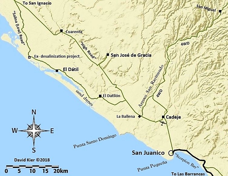
* In 2018, it was reported that the high road was re-graded and became the preferred route.
[Edited on 7-7-2021 by David K]
|
|
|
baja-chris
Junior Nomad
Posts: 91
Registered: 5-23-2008
Member Is Offline
|
|
Drove the high road northbound today. Very good condition with just a few bad spots. 72 miles pavement to pavement and 1 hour 35 minutes for that in
a stock Ford Raptor on stock tires just cruising 50, 60, 70 as washboards permit.
|
|
|
Skipjack Joe
Elite Nomad
Posts: 8091
Registered: 7-12-2004
Location: Bahia Asuncion
Member Is Offline
|
|
The "low road" has far less washboard and is smoother driving but is more confusing to navigate.
|
|
|
David K
Honored Nomad
Posts: 65480
Registered: 8-30-2002
Location: San Diego County
Member Is Offline
Mood: Have Baja Fever
|
|
The important thing about the low road is to keep to the edge of the salina rather than short cut straight across it. There are tracks going both ways
at each time there was a choice of routes.
The one time I took the straight tracks was the only mud pit encountered. Following the edge of the desert/salina, was a safe bet and no seawater mud
pits!
|
|
|
chippy
Super Nomad
Posts: 1795
Registered: 2-2-2010
Member Is Offline
|
|
I drove the low road in march. It's all good. Very easy to follow. FAST!!
|
|
|
alpha 1
Newbie
Posts: 3
Registered: 5-11-2022
Member Is Offline
|
|
I was on the road in early April ( motorcycle ) the road across the salt flats was flat & smooth, they were grading the dirt road between Cadeje
and San Juanico at the time and looked like they were working there way north
|
|
|


