| Pages:
1
2
3
4
5 |
David K
Honored Nomad

Posts: 64476
Registered: 8-30-2002
Location: San Diego County
Member Is Offline
Mood: Have Baja Fever
|
|
Again, poorly located, in reality is just, or was just, a few miles westward of La Miseria.
|
|
|
David K
Honored Nomad
Posts: 64476
Registered: 8-30-2002
Location: San Diego County
Member Is Offline
Mood: Have Baja Fever
|
|
Yes, the entire expedition diary of Padre Linck is published in English. It is Volume #5 of the Dawson Book Shop, Baja California Traveler Series.
|
|
|
4x4abc
Ultra Nomad
Posts: 4163
Registered: 4-24-2009
Location: La Paz, BCS
Member Is Offline
Mood: happy - always
|
|
any online source?
Harald Pietschmann
|
|
|
David K
Honored Nomad
Posts: 64476
Registered: 8-30-2002
Location: San Diego County
Member Is Offline
Mood: Have Baja Fever
|
|
Thank you, Lance... I will study these!
|
|
|
PaulW
Ultra Nomad
Posts: 3004
Registered: 5-21-2013
Member Is Offline
|
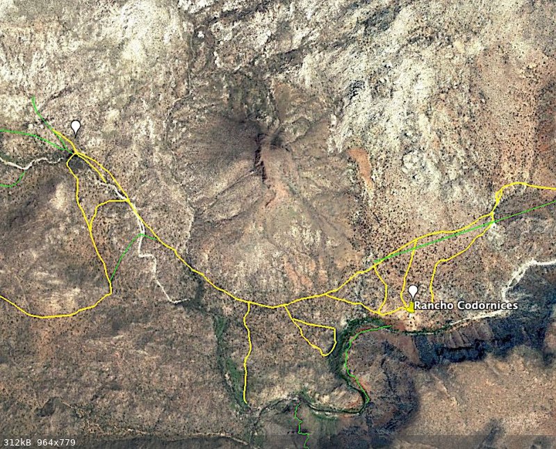
|
Figuring out the places
Let me clarify the rancho and San Antonio
The Rancho known as Condornices (ranch not shown on the Almac or the Atlas). And this ranch does not appear on Google earth.
The place nbentley1 found was San Antonio (AB) a small rancho on the road between the west coast north to Highway 1 at K257. This place is north of
the new rancho discussed below.
The Almac shows a place called Condornices, but that label is west of the present functional rancho.
In the image below shows the existing roads with a loop to Antonio and back to the main road.
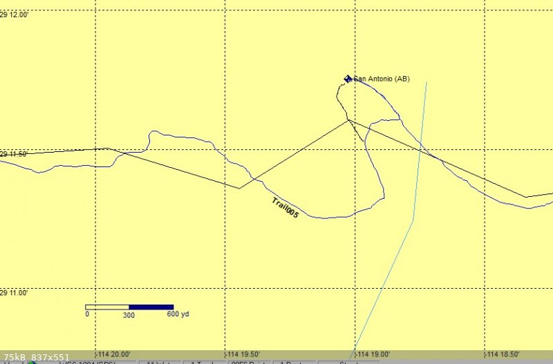
In this image I show the Cal Topo version with an old version of the road. The road shown was very overgrown on my first trip, but now that left side
of the loop is an easy drive.

Next is a screen shot from my GPS showing the old version like Cal Topo
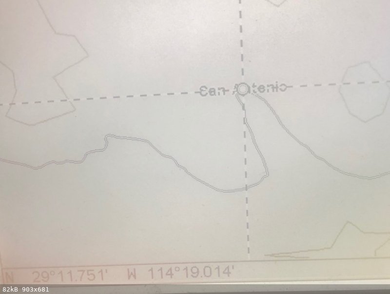
The next image shows the roads near Rancho Condornices. The GPS call that place “San Antonio”. I put “Rancho Condornices” label there.
|
|
|
4x4abc
Ultra Nomad
Posts: 4163
Registered: 4-24-2009
Location: La Paz, BCS
Member Is Offline
Mood: happy - always
|
|
so, which location is Keda/La Hermosura - 1 or 2?
1 - 29°11'43.62"N, 114°19'1.05"W
2 - 29°11'15.69"N, 114°17'51.46"W
Harald Pietschmann
|
|
|
nbentley1
Nomad
Posts: 140
Registered: 9-16-2016
Member Is Offline
|
|
Quote: Originally posted by PaulW  | Let me clarify the rancho and San Antonio
The Rancho known as Condornices (ranch not shown on the Almac or the Atlas). And this ranch does not appear on Google earth.
The place nbentley1 found was San Antonio (AB) a small rancho on the road between the west coast north to Highway 1 at K257. This place is north of
the new rancho discussed below.
The Almac shows a place called Condornices, but that label is west of the present functional rancho.
In the image below shows the existing roads with a loop to Antonio and back to the main road.
In this image I show the Cal Topo version with an old version of the road. The road shown was very overgrown on my first trip, but now that left side
of the loop is an easy drive.
Next is a screen shot from my GPS showing the old version like Cal Topo
The next image shows the roads near Rancho Condornices. The GPS call that place “San Antonio”. I put “Rancho Condornices” label there.
|
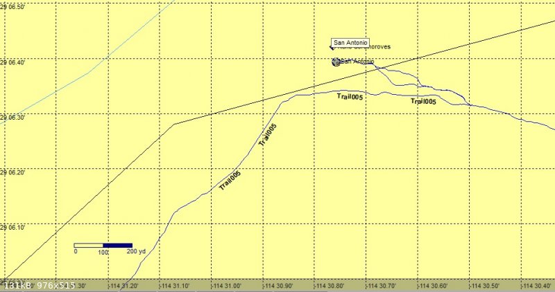
Just to confirm this, here are my GPS tracks from the trip

|
|
|
David K
Honored Nomad
Posts: 64476
Registered: 8-30-2002
Location: San Diego County
Member Is Offline
Mood: Have Baja Fever
|
|
Historic Rancho Codornices and San Antonio are the same ranch.
Harald, I will need to get on my PC to see where your waypoints are, heading to the beach soon!
|
|
|
bajaric
Senior Nomad
Posts: 600
Registered: 2-2-2015
Member Is Offline
|
|
Some maps call the abandoned rancho at the apex of that little bend in the road Rancho San Antonio, some call it Rancho Las Codornices. The 2009 BCA
calls it both names. Same place, two names. A different place called Cordornices is shown on the Baja California Almanac by a cross symbol but it is
about ten miles west of the area in question.
As noted, there are some modern ranchos in the area that may be periodically occupied. The old well at San Antonio/Codornices was probably hand dug
and went dry. It has been said that this general area has the least rainfall of anywhere in Baja. Its too far south to get the northern cold fronts
in the winter, and too far north to get the tropical moisture in the summer.
If the missionaries were having such a hard time locating a mission in this general area I wonder why they did not pick Catavina, which seems to have
plenty of water, or nearby Santa Ynez, instead picking Santa Maria where there was virtually no arable land for crops or grazing.
edit:
To answer my own question after thinking about it, the main diet of the indigenous in that area was sea food (turtles and scallops), so they might
have wanted to locate the mission close enough to the Sea to enable the Indians to forage for wild food if needed, as was common in the missionary
period.
[Edited on 7-22-2021 by bajaric]
|
|
|
John M
Super Nomad
Posts: 1906
Registered: 9-3-2003
Location: California High Desert
Member Is Offline
|
|
Baja Topographic Atlas Directory
Shows both names, same place

page B93 - scan is a little blurry eh?
The "Directory" also shows Codornices 10 miles or so west - with a slightly different spelling, leaving out the first "r"
John
|
|
|
4x4abc
Ultra Nomad
Posts: 4163
Registered: 4-24-2009
Location: La Paz, BCS
Member Is Offline
Mood: happy - always
|
|
| Quote: Originally posted by Lance S. | | Quote: Originally posted by 4x4abc | so, which location is Keda/La Hermosura - 1 or 2?
1 - 29°11'43.62"N, 114°19'1.05"W
2 - 29°11'15.69"N, 114°17'51.46"W |
Maybe david can show the location of the old rancho codornices. La Hermosura was at or near there I believe. It took Linck half an hour to reach it
from aqua leon. |
cool! But where is Agua Leon?
Harald Pietschmann
|
|
|
4x4abc
Ultra Nomad
Posts: 4163
Registered: 4-24-2009
Location: La Paz, BCS
Member Is Offline
Mood: happy - always
|
|
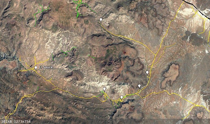
there are 6 ranchos in the vicinity
please fill in the names
Harald Pietschmann
|
|
|
4x4abc
Ultra Nomad
Posts: 4163
Registered: 4-24-2009
Location: La Paz, BCS
Member Is Offline
Mood: happy - always
|
|
here is what's in the INEGI database (last census)
Harald Pietschmann
|
|
|
TMW
Select Nomad
Posts: 10659
Registered: 9-1-2003
Location: Bakersfield, CA
Member Is Offline
|
|
The rancher that lives at the 4th pin from the left also owns the pin labeled El Sauce if that is the only ranch in that location. He told me he owned
a ranch further to the west.
Also nbentley1's GPS reading show him near or at Ranch San Antonio/Codornices but his pictures don't look nothing like what I saw when I was there. Of
course it's been several years since I was at the site. I remember lots of palm trees and no tree like his picture shows.
But I'm getting old so who knows. John M and I will have to make another trip down there to clear everything up.
|
|
|
PaulW
Ultra Nomad
Posts: 3004
Registered: 5-21-2013
Member Is Offline
|
|
Hi Harald,
What is the source of the image? It shows faint green lines that must be roads or trails that are very interesting. And the more prominent roads do
not look familiar.
|
|
|
David K
Honored Nomad
Posts: 64476
Registered: 8-30-2002
Location: San Diego County
Member Is Offline
Mood: Have Baja Fever
|
|
The last image Harald posted (last census) what is ladled Los Codornices is not the old ranch site in the palm tree oasis (which is the left pin).
Harald, we had threads about Agua Leon and Leon Grande... Both are between Punta Prieta and Los Codornices (San Antonio). They were important gold
mining/ water supply points mentioned in the book, 'Long Walk to Mulegé' (a book from 1980 about a 1921 walking trip from San Diego by a pair of
World War I vets).
Harald, you even made a map with both Leons on it...

|
|
|
David K
Honored Nomad
Posts: 64476
Registered: 8-30-2002
Location: San Diego County
Member Is Offline
Mood: Have Baja Fever
|
|
On the 1971 Geology Map:
Los Cordonices [sic] is at the very top edge.
Punta Prieta is at the loser edge.
Leon Grande is midway between the two.

=====================================================================
On the 1948 Geology Map:
Leon Grande and Agua Leon are both shown.

===========================================================================
On the 1918 Goldbaum Map (1925 printing):
Chapala is at the top.
Codornices is below.
Agua Leon is next.
Leon Grande is at the bottom.

*It was Goldbaum's map that the guys in a 'Long Walk to Mulegé' used to navigate!
|
|
|
4x4abc
Ultra Nomad
Posts: 4163
Registered: 4-24-2009
Location: La Paz, BCS
Member Is Offline
Mood: happy - always
|
|
so, Keda is Codornices
where and what is Kanin?
Is Agua Leon Kanin?
Harald Pietschmann
|
|
|
4x4abc
Ultra Nomad
Posts: 4163
Registered: 4-24-2009
Location: La Paz, BCS
Member Is Offline
Mood: happy - always
|
|
| Quote: Originally posted by PaulW | Hi Harald,
What is the source of the image? It shows faint green lines that must be roads or trails that are very interesting. And the more prominent roads do
not look familiar.
|
I created a digital Baja Almanac (almost finished).
It has anything that has been driven (yellow or black) or walked (green) in it
Started 7 years ago with the idea to record Camino real - make it visible
In the process I recorded everything else that is visible from space
found airstrips in wow places - about 600
Harald Pietschmann
|
|
|
4x4abc
Ultra Nomad
Posts: 4163
Registered: 4-24-2009
Location: La Paz, BCS
Member Is Offline
Mood: happy - always
|
|
on his trip north or south?
Harald Pietschmann
|
|
|
| Pages:
1
2
3
4
5 |


