| Pages:
1
2 |
geoffff
Senior Nomad

Posts: 710
Registered: 1-15-2009
Member Is Offline
|
|
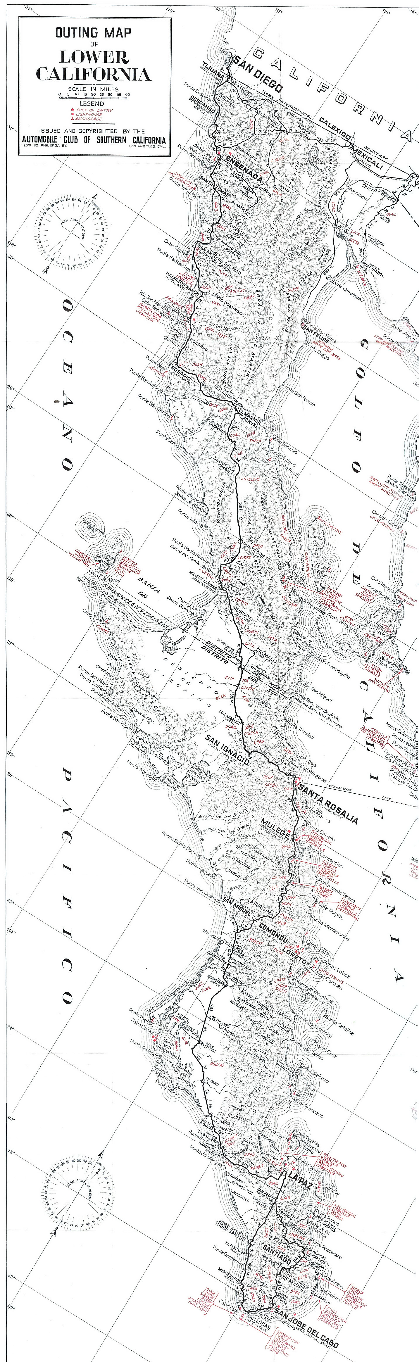
1969 AAA map
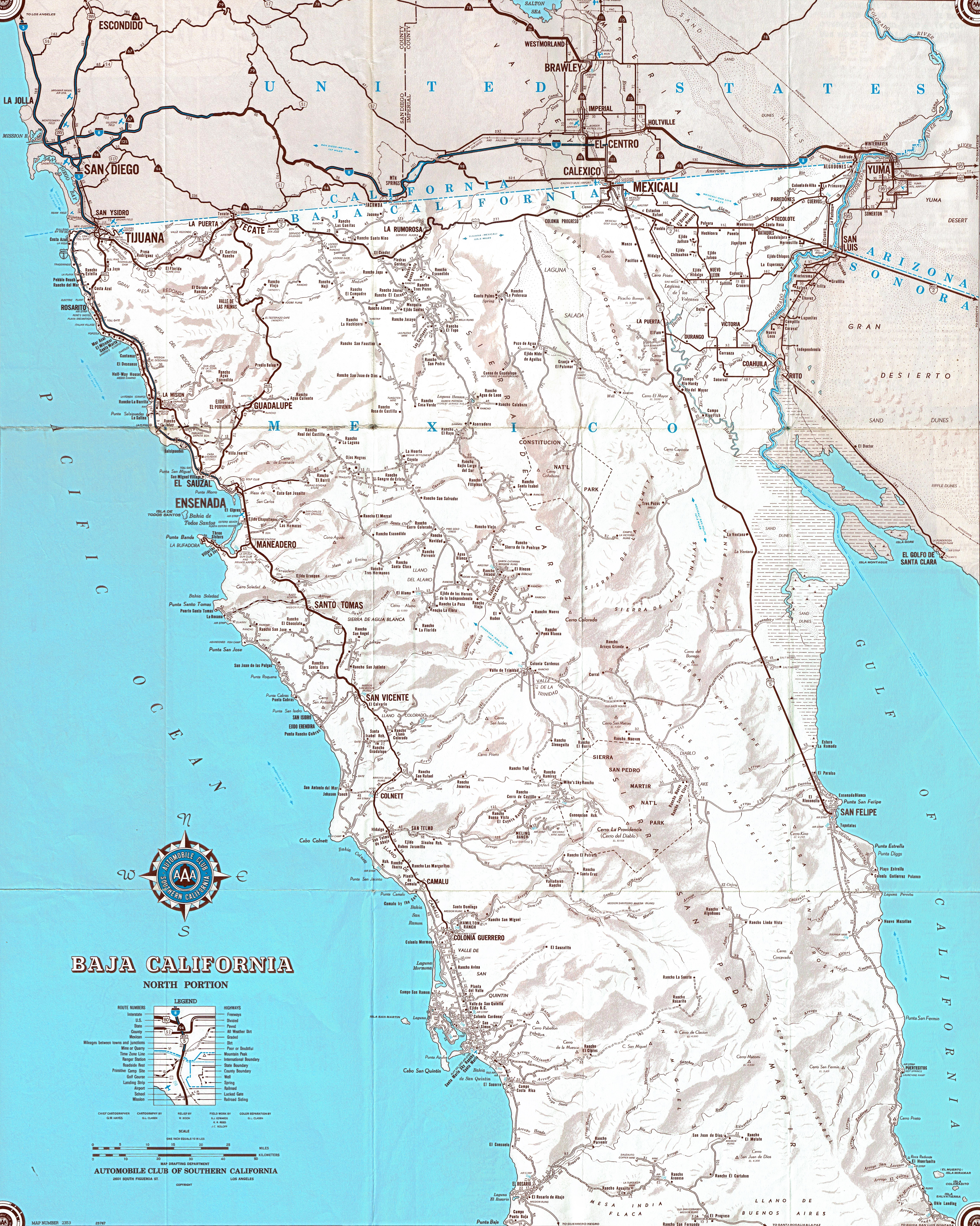
For DavidK and other map enthusiasts --
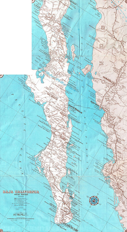
Here is a scan of the 1967 [edit:1969] AAA map of Baja California (I found on Ebay).
I find it funny that they found Bahia Tortugas and the tip of the Vizcaino peninsula so unimportant that they used that area for the map index (not
shown).
1969--Baja-California--AAA-Map--North.jpg
1969--Baja-California--AAA-Map--South.jpg


[Edited on 9-27-2021 by geoffff]
|
|
|
David K
Honored Nomad
Posts: 65443
Registered: 8-30-2002
Location: San Diego County
Member Is Offline
Mood: Have Baja Fever
|
|
Many thanks, this is great!!
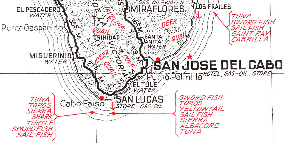
That is the August 1969 map... look closely at the cover below the logo.
Another key is the pavement reaching San José del Cabo. In 1967 it was closer to La Paz. The year before (1966), it ended 10 miles south of La Paz.
|
|
|
geoffff
Senior Nomad
Posts: 710
Registered: 1-15-2009
Member Is Offline
|
|
Thank you! I'll correct...
|
|
|
David K
Honored Nomad
Posts: 65443
Registered: 8-30-2002
Location: San Diego County
Member Is Offline
Mood: Have Baja Fever
|
|
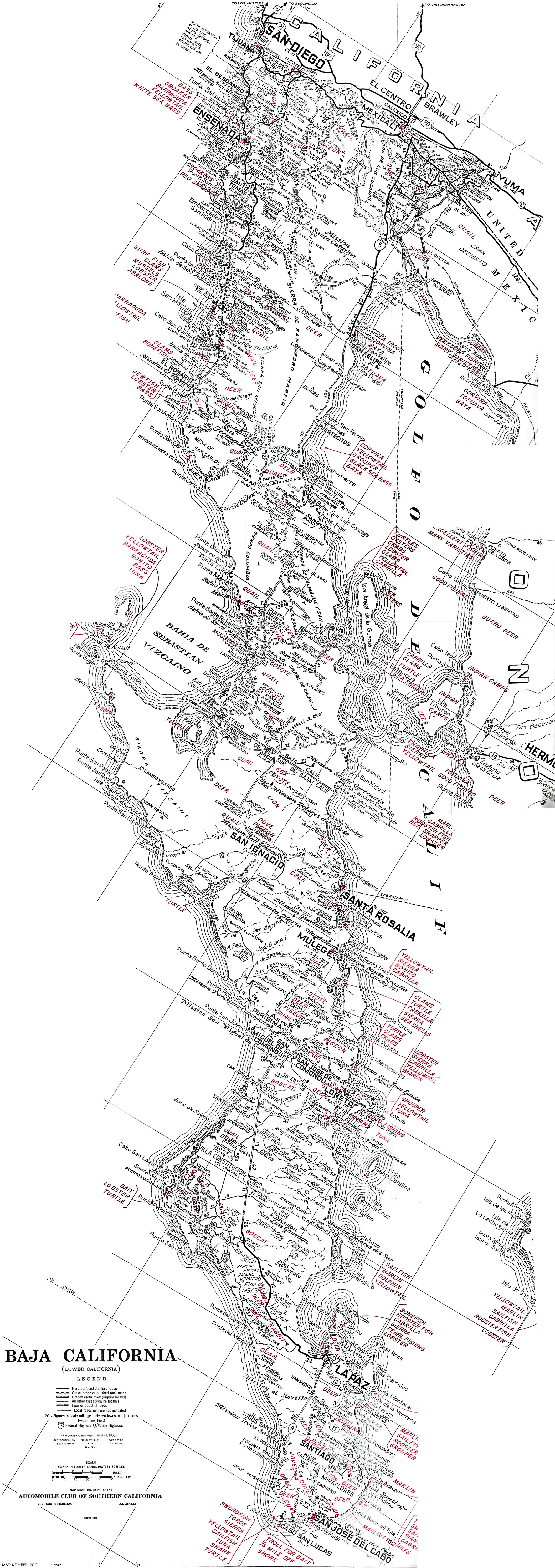
If you can find the 1970 and 1972 editions, that would be awesome... They will show the progress of the Transpeninsular Highway construction, which
was a huge deal for the auto club and us old Baja travelers. I have the 1971, 1973, and 1974 maps (thanks to Baja Nomads).
PS, I noticed the gap in my scans of the 1955 map... I can fill that in for your page.
|
|
|
geoffff
Senior Nomad
Posts: 710
Registered: 1-15-2009
Member Is Offline
|
|
Quote: Originally posted by David K  | | Another key is the pavement reaching San José del Cabo. In 1967 it was closer to La Paz. The year before (1966), it ended 10 miles south of La Paz.
|
That's just about all that changed apart from the removal of the fishing & game notes and the out-of-style coastline vignettes. Notice "de" typo,
too 


|
|
|
geoffff
Senior Nomad
Posts: 710
Registered: 1-15-2009
Member Is Offline
|
|
And I re-stitched your 1962 map scan, if you want to re-download it. I had some errors in the Cabo area.
And, while we are fixing gaps, your 1975 Senterfitt map has a scanning gap near the top too.
[Edited on 9-27-2021 by geoffff]
|
|
|
geoffff
Senior Nomad
Posts: 710
Registered: 1-15-2009
Member Is Offline
|
|
Oh, and while we are at it, here's a stitch of your 1930 AAA map scans:
1930--Baja-California--AAA.jpg

|
|
|
David K
Honored Nomad
Posts: 65443
Registered: 8-30-2002
Location: San Diego County
Member Is Offline
Mood: Have Baja Fever
|
|
OK I scanned the 1975 Senterfitt map, unfolded in that area south of San Felipe. Check your email. Thanks for al you do!!
|
|
|
geoffff
Senior Nomad
Posts: 710
Registered: 1-15-2009
Member Is Offline
|
|
It's totally fun for me.
I'm amused that Cabo San Lucas has a "Store"
|
|
|
David K
Honored Nomad
Posts: 65443
Registered: 8-30-2002
Location: San Diego County
Member Is Offline
Mood: Have Baja Fever
|
|
In 1955 it was a fishing village and a cannery.
|
|
|
BajaTed
Senior Nomad
Posts: 859
Registered: 5-2-2010
Location: Bajamar
Member Is Offline
|
|
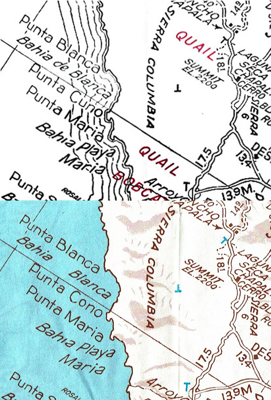
One of the last maps that shows Port Isabel
Es Todo Bueno
|
|
|
David K
Honored Nomad
Posts: 65443
Registered: 8-30-2002
Location: San Diego County
Member Is Offline
Mood: Have Baja Fever
|
|
Good eye!
It is also on the 1934 AAA map: https://www.raremaps.com/gallery/detail/69977%20/%5BBaja+Pen...
[Edited on 9-28-2021 by David K]
|
|
|
geoffff
Senior Nomad
Posts: 710
Registered: 1-15-2009
Member Is Offline
|
|
I had to look it up!
https://en.wikipedia.org/wiki/Port_Isabel,_Sonora

I'm not sure I can see any remains in Google Earth.
|
|
|
David K
Honored Nomad
Posts: 65443
Registered: 8-30-2002
Location: San Diego County
Member Is Offline
Mood: Have Baja Fever
|
|
Somebody located it on Wikimapia (just west of the shrimp farm): http://wikimapia.org/#lang=en&lat=31.789041&lon=-114...
More on Port Isabel:
http://the-wanderling.com/colorado.html
Here is an 1864 map showing Port Isabel: https://www.davidrumsey.com/luna/servlet/detail/RUMSEY~8~1~1...
another map: https://mojavedesert.net/steamboats/800-colorado-river-ports...
History:
Port Isabel was a seaport established on Port Isabel Slough in 1865 during the American Civil War in Sonora, Mexico in the mouth of the Colorado River
on the Gulf of California. It was founded to support the increased river traffic caused by the gold rush that began in 1862 on the Colorado River and
the Yuma Quartermaster Depot newly established in 1864 to support the Army posts in the Arizona Military District. The slough was discovered in 1865
by the Captain W. H. Pierson of the schooner Isabel, that first used the slough to transfer its cargo to steamboats safe from the tidal bore of the
Colorado River. Shortly afterward Port Isabel was established 3 miles up the slough and replaced Robinson's Landing as the place where cargo was
unloaded in the river from seagoing craft on to flat bottomed steamboats of the Colorado River and carried up to Fort Yuma and points further north on
the river.
By 1867, Port Isabel, was situated on Port Isabel Slough whose mouth lay to the east of the main channel of the Colorado River on its channel east of
Montague Island about 2 1⁄2 miles from its entrance, at the first good landing place, the shores below being of very soft mud. Port Isabel, served
as a location for repairing the river steamers and barges at a location about 2 miles above Port Isabel on what was called Shipyard Slough that became
the site called Ship Yard, which had a few frame buildings, a dry dock and a ship way where steamboats could be constructed or repaired.
The arrival of the Southern Pacific Railroad in Yuma in 1877 signaled the end of Port Isabel. Trade by sea was replaced with cargo carried by rail. In
1877, George Alonzo Johnson sold his Colorado Steam Navigation Company to the Southern Pacific Railroad. Yuma then became the head of navigation for
steamboats operating on the river. Port Isabel was abandoned by 1879, its shipyard being moved to Yuma, Arizona.
|
|
|
4x4abc
Ultra Nomad
Posts: 4454
Registered: 4-24-2009
Location: La Paz, BCS
Member Is Offline
Mood: happy - always
|
|
can anyone pinpoint Puerto Isabel on today's Google Earth?
Harald Pietschmann
|
|
|
4x4abc
Ultra Nomad
Posts: 4454
Registered: 4-24-2009
Location: La Paz, BCS
Member Is Offline
Mood: happy - always
|
|
I think, I found it
31°52'14.42"N, 114°52'4.56"W
Harald Pietschmann
|
|
|
geoffff
Senior Nomad
Posts: 710
Registered: 1-15-2009
Member Is Offline
|
|
Nice! I keep forgetting Wikimapia sometimes has some good stuff.
I will let go of my hopes for something visible of Port Isabel in Google Earth. It looks like the mouth of the Colorado River wanders about quite a
lot over the years, removing any evidence.
|
|
|
mtgoat666
Platinum Nomad
Posts: 20591
Registered: 9-16-2006
Location: San Diego
Member Is Offline
Mood: Hot n spicy
|
|
Port Isabel was located northwestish of Golfo de Santa Clara, basicly the accessible coast south of shrimp farm, north of golfo de santa clara.
The "shipyard slough" is the slough immediately southwest of the old shrimp farm.
[Edited on 9-29-2021 by mtgoat666]
Woke!
Hands off!
“Por el bien de todos, primero los pobres.”
“...ask not what your country can do for you – ask what you can do for your country.” “My fellow citizens of the world: ask not what America
will do for you, but what together we can do for the freedom of man.”
Pronoun: the royal we
|
|
|
David K
Honored Nomad
Posts: 65443
Registered: 8-30-2002
Location: San Diego County
Member Is Offline
Mood: Have Baja Fever
|
|
You are perhaps too far north... It was at the fork in this river side canal (per the Wiki map): 31.7886656,-114.6841088 (just west of the shrimp
farm) or using the other format: 31° 47' 24.8" N 114° 41' 9.6" W
This is closer to the 2.5 miles up the river mentioned in history links.
[Edited on 9-29-2021 by David K]
|
|
|
David K
Honored Nomad
Posts: 65443
Registered: 8-30-2002
Location: San Diego County
Member Is Offline
Mood: Have Baja Fever
|
|
| Quote: Originally posted by mtgoat666 |
Port Isabel was located at what is today the town named Golfo de Santa Clara.
The "shipyard slough" is the slough immediately southwest of the old shrimp farm. |
The Shrimp Farm and Port Isabel were off the Colorado River on a side channel. El Golfo de Santa Clara is below the river, on the gulf coast. It is
close but not the same place: https://davidrumsey.georeferencer.com/maps/73ecc48e-abff-564...
[Edited on 9-29-2021 by David K]
|
|
|
| Pages:
1
2 |


