| Pages:
1
2
3
4 |
4x4abc
Ultra Nomad

Posts: 4163
Registered: 4-24-2009
Location: La Paz, BCS
Member Is Offline
Mood: happy - always
|
|
Quote: Originally posted by TinCanAdventureVan  | Wow that geyser looks amazing!
I havent heard about the waterfall/Oasis west of SF. I've only heard of the one further south near Cataviña. Ive seen it called several things but
often referred to as the Santa Maria Oasis. Looks like a far hike from Cataviña but it appears you can drive to within about 5 miles of it from the
east without having to do any rock crawling and then hike the rest of the way. Have any of you been there? |
many names for Poza de Escuadra (Square Pool)
hike from the east 5 hours (one of the best hikes in Baja)
the road from the west has been so abused that only competent 4x4 rigs (2 lockers) with good drivers should attempt to get close to the pool (you get
to within 3/4 of a mile)
2WD and average 4WD can get within 5 miles
2+ hours hike in on the downhill
3+ hours on the way back - uphill
I drove in this year and was surprised about the bad shape of the road. The last 3 years have seen more destruction than the 30 years before
Harald Pietschmann
|
|
|
4x4abc
Ultra Nomad
Posts: 4163
Registered: 4-24-2009
Location: La Paz, BCS
Member Is Offline
Mood: happy - always
|
|
| Quote: Originally posted by TinCanAdventureVan | Wow those are some great tips Maderita!
I've actually been to the hot springs at Puertecitos and had a great time soaking there. I think I noticed on google maps theyre marked as temporarily
closed but I will probably check it out and see what the story is. I saw someone online complaining that they charge to much for the hot springs and
that there's free ones further south but I remember when I went maybe years ago thinking the price was fine.
I really like your idea of taking Mex 3 and climbing into the mountains. I think you may have changed the last leg of my trip! a 2wd van should handle
those roads from Ojos Negros to Laguna Hanson and on to La Rumorosa? I was planning on stopping to see the pictographs there.
Seriously thank you for all of your help and ideas! I wish I was going to be around still for your rock climbing gathering! |
the pictograph site in La Rumorosa is closed (no idea why)
Harald Pietschmann
|
|
|
Maderita
Senior Nomad
Posts: 634
Registered: 12-14-2008
Location: San Diego
Member Is Offline
|
|
4x4abc,
Is El Vallecito currently closed every day? I believe the normal days of operation are Wednesday through Sunday only; closed Monday & Tuesday.
The government agency INAH oversees El Vallecito and should be able to provide the current status for visitors.
TCAV,
De nada. The Ojos Negros - Laguna Hanson - La Rumorosa route will almost certainly be 2WD through mid-November. The dirt roads are mostly graded, just
a bit rough. Airing the van tires down to 20-22 psi is not required, but will preserve your dental fillings. A sedan can do it, just by taking it a
little slower. Thanksgiving through March the situation can change at those higher elevations (over 5,000'), such as, a foot of snow or deep mud
sections.
|
|
|
David K
Honored Nomad
Posts: 64480
Registered: 8-30-2002
Location: San Diego County
Member Is Offline
Mood: Have Baja Fever
|
|
| Quote: Originally posted by Maderita |
TCAV,
De nada. The Ojos Negros - Laguna Hanson - La Rumorosa route will almost certainly be 2WD through mid-November. The dirt roads are mostly graded, just
a bit rough. Airing the van tires down to 20-22 psi is not required, but will preserve your dental fillings. A sedan can do it, just by taking it a
little slower. Thanksgiving through March the situation can change at those higher elevations (over 5,000'), such as, a foot of snow or deep mud
sections.
|
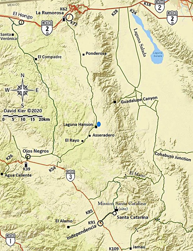
I made a road log of this route in 2018 plus my map.
Road Log: Hwy. 3 to Hwy. 2 via Laguna Hanson
0.0 Miles Hwy. 3 at Km. 54.5 (from Ensenada).
2.7 Fork, go left
3.8 Fork, go right
4.8 Oak Grove
5.2 Fork, go left (elev. 4,000')
11.2 First pine trees (elev. 5,000')
13.7 Rancho El Rayo
15.1 Road right to Rancho La Botella, cattle guard crossing.
16.2 Aserradero (abandoned homes) a former sawmill, elev. 5,277'.
16.4 Food advertised.
17.5 Cabins for rent, food store "Oxxxo".
19.1 Fork, go left.
19.8 LAGUNA HANSON (cabins) 68 pesos camping fee, elev. 5,300'
20.5 Km. 60 sign (37.2 miles from La Rumorosa, Hwy. 2).
22.1 Road east to Rancho San Luis... located above the top of Guadalupe Canyon.
23.8 Km. 55 sign.
24.6 Rancho Rodeo del Rey, an abandoned/ deteriorated hotel/restaurant.
25.0 Rancho Bajío Largo road west.
26.9 Km. 50 sign.
35.6 Rancho El Topo road west.
35.7 Km. 35 sign.
40.4 Former mining area of La Milla.
41.4 Condor road west, elev. 4,916'.
41.9 Km. 25 sign.
42.7 Junction with a road southwest from Las Margaritas.
44.4 Road to the east.
45.6 Rancho La Ponderosa road east.
47.2 Km. 17 sign.
48.7 Rancho Nuevo road east
53.1 Km. 7, 'Inspection' station, open gate.
55.1 Blacktop paved road begins.
55.4 Parques Los Potrillos and El Tesoro campgrounds.
57.5 Highway 2 (Km. 72), La Rumorosa.
|
|
|
David K
Honored Nomad
Posts: 64480
Registered: 8-30-2002
Location: San Diego County
Member Is Offline
Mood: Have Baja Fever
|
|
No doubt some Mexican hikers named it that when they first posted about it on some platform. There is no mention of that name in any of the books or
publications I have seen from before seeing it on Facebook.
Look how well my name for the steep grade near the mission has been accepted by Mexican off-roaders... all Spanish videos with the word "widowmaker"
included!
Names start somewhere and are either accepted or changed. I think I have only named two places in Baja in all my years, 'Shell Island' and
'Widowmaker'.
[Edited on 10-1-2021 by David K]
|
|
|
mjs
Nomad
Posts: 305
Registered: 2-20-2013
Location: Off grid in San Felipe
Member Is Offline
|
|
The turn off to Laguna Hansen/Compadre Trail at K54 on Hwy 3 is closed. Barbed wire strung tight (not a gate) with a deep backhoe ditch behind it
across the road. Might be possible to access the lake coming from Ojos but I have not tried it lately.
|
|
|
David K
Honored Nomad
Posts: 64480
Registered: 8-30-2002
Location: San Diego County
Member Is Offline
Mood: Have Baja Fever
|
|
| Quote: Originally posted by mjs | | The turn off to Laguna Hansen/Compadre Trail at K54 on Hwy 3 is closed. Barbed wire strung tight (not a gate) with a deep backhoe ditch behind it
across the road. Might be possible to access the lake coming from Ojos but I have not tried it lately. |
I had heard that before (earlier this year)... When did you find it that way? I will update the guide. This was the signed main road to Hanson in 2018
(and before).
|
|
|
willardguy
Elite Nomad
Posts: 6451
Registered: 9-19-2009
Member Is Offline
|
|
last report Ride Baja guys had no problem accessing from Ojo's....

|
|
|
geoffff
Senior Nomad
Posts: 643
Registered: 1-15-2009
Member Is Offline
|
|
Here? (GPS: 31.864, -116.1156)
I passed through here just fine in 2016, but that was 5 years ago.

|
|
|
mjs
Nomad
Posts: 305
Registered: 2-20-2013
Location: Off grid in San Felipe
Member Is Offline
|
|
Last time I went by was September 8th, 2021. Still closed same as last spring. There was/is a section of fence to the side that a bike could get
around. Would have required some fence removal And bush wacking to get my truck through at that time.
ETA. Geoff, yes that is the spot.
[Edited on 10-1-2021 by mjs]
|
|
|
David K
Honored Nomad
Posts: 64480
Registered: 8-30-2002
Location: San Diego County
Member Is Offline
Mood: Have Baja Fever
|
|
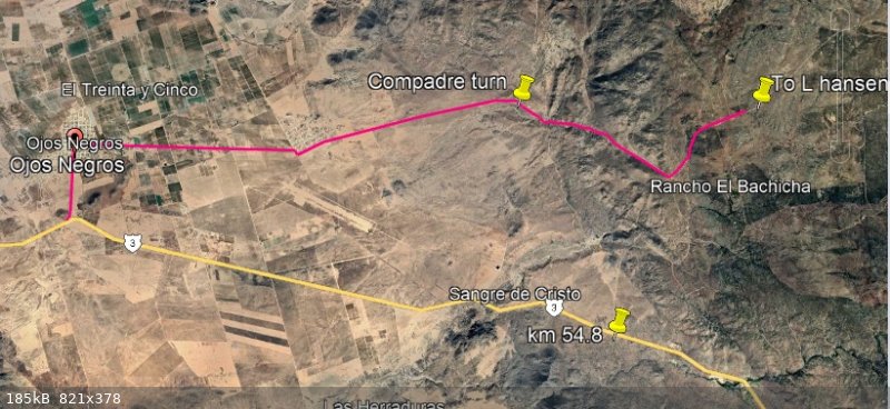
Km. 54.5
Geoff, it was the signed road for the Park and Laguna Hanson in August 2018 when I was doing my final research trip for the Baja Bound Road Guide.

A fork in the road north of the highway:
|
|
|
David K
Honored Nomad
Posts: 64480
Registered: 8-30-2002
Location: San Diego County
Member Is Offline
Mood: Have Baja Fever
|
|
Paul, an Aug. 2021 street view image show a big gate there, signed Sangre de Cristo. Is this unlocked and you passed through?

|
|
|
PaulW
Ultra Nomad
Posts: 3005
Registered: 5-21-2013
Member Is Offline
|
|
I just drew a track on Google Earth I have never been there.
I would refer others to ingnor Sangre and use the other road I drew from Ojos
I will delete the sangre post
[Edited on 11-23-2021 by PaulW]
|
|
|
PaulW
Ultra Nomad
Posts: 3005
Registered: 5-21-2013
Member Is Offline
|
|
Avoid Sangre de Cristo and K58 to get to L Hansen Just drive the road shown from Ojos Negro
|
|
|
David K
Honored Nomad
Posts: 64480
Registered: 8-30-2002
Location: San Diego County
Member Is Offline
Mood: Have Baja Fever
|
|
Thank you, Paul!
|
|
|
pjpvi
Nomad
Posts: 110
Registered: 2-17-2019
Member Is Offline
|
|
Back to the original topic ...
On my recent Baja trip I was going to repeat the route I did last year from Hwy 5 (Coco's) exiting onto Hwy 1 via Calamajué Wash. I stopped and
visited with Coco at his new place and he said we would encounter a locked gate and to just use the bypass around it. I can't believe I didn't take a
pic of the gate but it is located at (29.529245, -114.283586) and is very clearly marked as closed and no entry. I was traveling with a couple other
vehicles and I went half way around the short steep bypass but we all mutually agreed that given the very clear messaging on the signs that we would
abandon this route.
Anyone know what the deal is with the locked gate? We did bump into a couple riding motorcycles a few days later that said they went around the gate
and had no issues.
|
|
|
David K
Honored Nomad
Posts: 64480
Registered: 8-30-2002
Location: San Diego County
Member Is Offline
Mood: Have Baja Fever
|
|
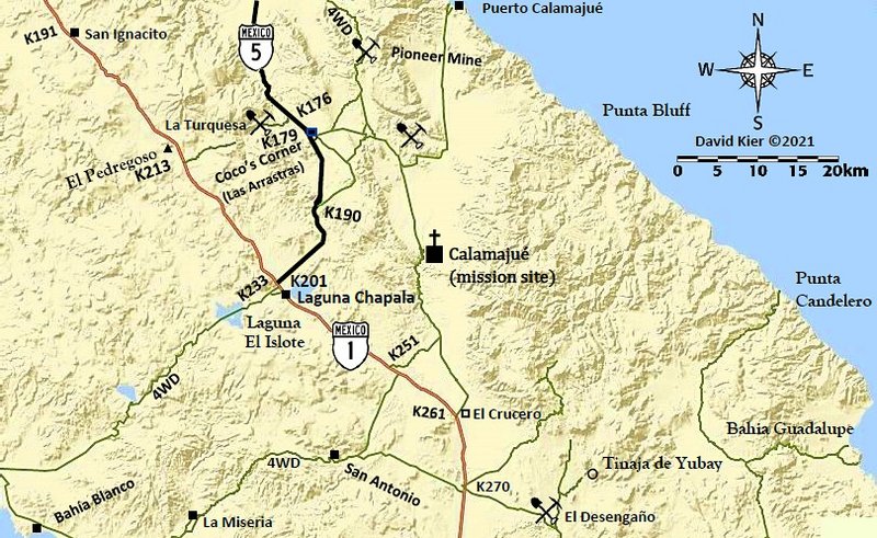
Why go to the old Coco's Corner from the new, if Calamajué is your goal?
Use the original road from Las Arrastras (New Coco's) to Calamajué. It leaves the older main road just after it curves south. A second road joins it
a bit beyond. Use Google Earth to see them.
I show these roads on my map, too (they are also how you get to the Pioneer Mine road):
|
|
|
pjpvi
Nomad
Posts: 110
Registered: 2-17-2019
Member Is Offline
|
|
Why didn't I go your way, because I wasn't aware of it and went the way I did last year that worked well. Now I know another way.
Thanks
[Edited on 11-24-2021 by pjpvi]
[Edited on 11-24-2021 by pjpvi]
[Edited on 11-24-2021 by pjpvi]
|
|
|
PaulW
Ultra Nomad
Posts: 3005
Registered: 5-21-2013
Member Is Offline
|
|
Possible to avoid the gate?
I have not been to the new gate. I bet the gate is close to Old Coco’s place. If so, here are some roads in the area.
At K179.5
Follow the blue road past New Coco’s place and take the first left. Decent road that has not been used for racing for a while. Be aware the race
just when thru there and the turn off the old Hwy 5 may be hidden behind the bank on the side of the old road.
Do not take the gold colored road which is old Hwy5 and the race track, and lead’s to old Coco;s place and back to new Hwy5.
The image also shows the new Hwy to Chapala.
When you follow the blue road you will come to the intersection to the Pioneer mine and follow to Calamajue.
Make the hard right turn onto the green road to Calamajue.
To help you find the blue road at new Coco look on your device for these coords
29 32.984, -114 20.383 and 29 33, -114 20.33

|
|
|
David K
Honored Nomad
Posts: 64480
Registered: 8-30-2002
Location: San Diego County
Member Is Offline
Mood: Have Baja Fever
|
|
| Quote: Originally posted by pjpvi | Why didn't I go your way, because I wasn't aware of it and went the way I did last year that worked well. Now I am know another way.
Thanks
|
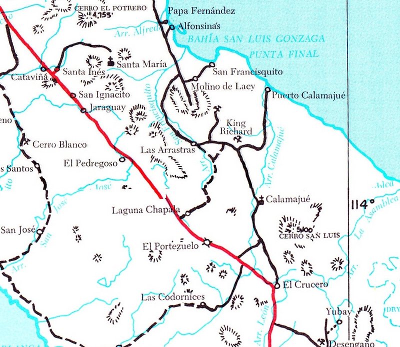
I am only surprised that Coco didn't provide it as an option... It was the main route of 'Hwy. 5' prior to 1983 (when the road from Chapala was graded
to Puerto Calamajué). Coco's original corner was where that new road met the road to Gonzaga (graded in 1986).
1975 Map:
|
|
|
| Pages:
1
2
3
4 |


