| Pages:
1
2
3 |
David K
Honored Nomad

Posts: 65501
Registered: 8-30-2002
Location: San Diego County
Member Is Offline
Mood: Have Baja Fever
|
|
Where is that old Baja road, you ask? (repost from 2003) + Leon Grande Chat
posted on 12-13-2003 at 07:48 PM
Where is that old Baja road, you ask?
I am referring to the pre-December, 1973 Baja main road. Everything changed after December 1973 as far as Baja travel and number of visitors.
I was just a kid when my folks and I drove to the tip in 1966 in our Jeep Wagoneer. But, I was already infected with Baja Fever and my favorite book
was Gerhard & Gulick's LOWER CALIFORNIA GUIDEBOOK (The Baja Bible). We went to Gonzaga the year before and to L.A. Bay the following year. The
next trip down Baja (to Loreto) was in July, 1973. The highway was under construction and I took many notes and mileages as to its location compared
with the old road. That July, pavement ended near Mission San Fernando (near El Progreso) and didn't start again until near Punta Prieta (in sections)
with solid pavement starting about Villa Jesus Maria. We were on the old road from Agua Dulce (10 miles beyond San Agustin) to almost Laguna Chapala.
The old road locator:
Just past where the highway crosses Arroyo El Rosario is where the old road left the valley using a side canyon, that the new road stays above, just
west.
The old road crosses the new and parallels it to the south, Rancho Aguajito and the turquoise mines are along it.
El Progreso was moved north a half mile to the highway from the old road.
The road left to Rancho Penjamo is along the old road, as is Aguila and Guayaquil.
The abandoned Pemex and trailer park 'San Agustin' is a half mile south of the original San Agustin, on the old road, as is Café Sonora a couple
miles ahead.
Agua Dulce is off the old road, a couple miles to the left of Km. 157. The old road stays about 1-2 miles east/left of the highway in the La Virgen
boulder area. The old road rejoins the highway just before the palapa by the rock art cave, 2 miles before Cataviña.
The highway is next to the old road past San Martin and over to the first little dry lake. At the Pedregoso boulder mountain, the old road went around
the west side, whereas the new highway goes around the east side.
At the first sight of the Laguna Chapala valley, the old road continued straight towards the old ranch site, along a little hill just north of the dry
lake bed. This section before the ranch was perhaps the worst in all of the Baja road... deep, fine powder Baja dust that would cover your vehicle
completely. You would drive blind after fixing onto the trees by Rancho Chapala and hoping for the best! Then, after the ranch, you got to open it up
and drive 60 mph on the dry lake to blow a lot of that dust off. That best of the old road only lasted a couple miles, however. That Chapala dust
would stay with the Jeep for many car washes over the following years!
The new highway stays to the right of the dust field, along the hill, and to the right (west) of the dry lake. Rancho Chapala moved to the highway and
was renamed Nuevo Chapala. The new Chapala to Puerto Calamajué, then on to Gonzaga and San Felipe road was built from from about 1982-87. Coco
started his corner after that first section was built.
Both old and new roads come together where you leave the Chapala valley and see that beautiful view of the desert and mountains to the south.
Beyond El Crucero (where the road turns from southeast to south at the base of a hill) both roads are together. In a few miles the old road goes off
to the right (west) of the new and parallels it to Punta Prieta.
At Rosarito, the new highway swings west down the arroyo a couple miles then turns south to Guerrero Negro. The old main road went straight south from
Rosarito and eventually went to the center of the peninsula at El Arco. Some truckers running supplies to the new town of Guerrero Negro went along
the 'coast route', then took desert trails on to San Ignacio. The new highway does the same, passing near Guerrero Negro then swinging to the
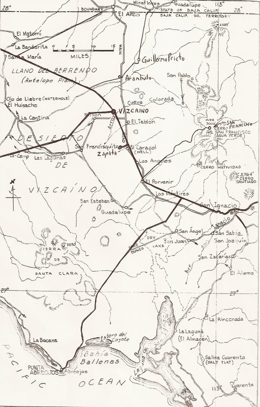
southeast for San Ignacio. The old road coming south from El Arco joins the new near Vizcaino (a new town since the highway was built).
Vizcaino to San Ignacio finds both routes near each other. San Ignacio to Mulegé, the same.
Along Bahia Concepcion, the old road can be seen in the cliff, right above the water in many places. This was built and maintained by the prisioners
of the old territorial prison in Mulegé (closed after the highway was built ending the isolation).
Just south of Bahia Concepcion, the old main road went inland via Comondú where today's highway goes south through Loreto. Both rejoin at
Insurgentes. Travelers to Loreto could get to La Paz by driving to San Javier and then on to Santo Domingo on the main road. The road south of Loreto
ended at Ligüí.
Pavement in '66 began about 100 miles north of La Paz and ended again, about 10 miles south of La Paz. They were building the new road and we drove on
it (unpaved) until past San Bartolo. It was just a two track jeep trail from there to Cabo San Lucas! The new highway stays to the east of Santiago
and Miraflores, where the old road naturally went right through these pretty villages...
I hope some of you find this a bit interesting... thank you for allowing me to share from my childhood memories and later observations!
Maps, anyone?
[Edited on 12-10-2021 by David K]
|
|
|
bajaric
Senior Nomad
Posts: 678
Registered: 2-2-2015
Member Is Offline
|
|
Quote:
Beyond El Crucero (where the road turns from southeast to south at the base of a hill) both roads are together. In a few miles the old road goes off
to the right (west) of the new and parallels it to Punta Prieta.
end quote
I drove on this part of old Hwy. 1 (or part of it) a month or two back. Even in a full sized pickup was scraping across the high centers at a couple
of spots, but nothing impossible. No rocks, smooth ride. Saw some nice central desert country east of Mesa EL Leoncito; lots of cardons and other
desert fauna.
I wonder how the section of old Hwy 1 that goes from near Villa Jesus Maria down towards El Arco is holding up. I think that may have been a part of
some off road races, wonder if these days it drivable in a 2WD truck to El Arco?
|
|
|
100X
Nomad
Posts: 234
Registered: 11-3-2021
Member Is Offline
Mood: Thankful
|
|
"Maps, anyone?"
If that is an offer, yes please!
A life of fears leads to a death bed of regrets.
Find someone who will take care of you, and take care of them.
|
|
|
geoffff
Senior Nomad
Posts: 713
Registered: 1-15-2009
Member Is Offline
|
|
Yes, this is begging for a map 
If it would be fun for someone to mark some points into a KMZ or GPX file I am happy to plot them on a map.
-- Geoff
|
|
|
David K
Honored Nomad
Posts: 65501
Registered: 8-30-2002
Location: San Diego County
Member Is Offline
Mood: Have Baja Fever
|
|
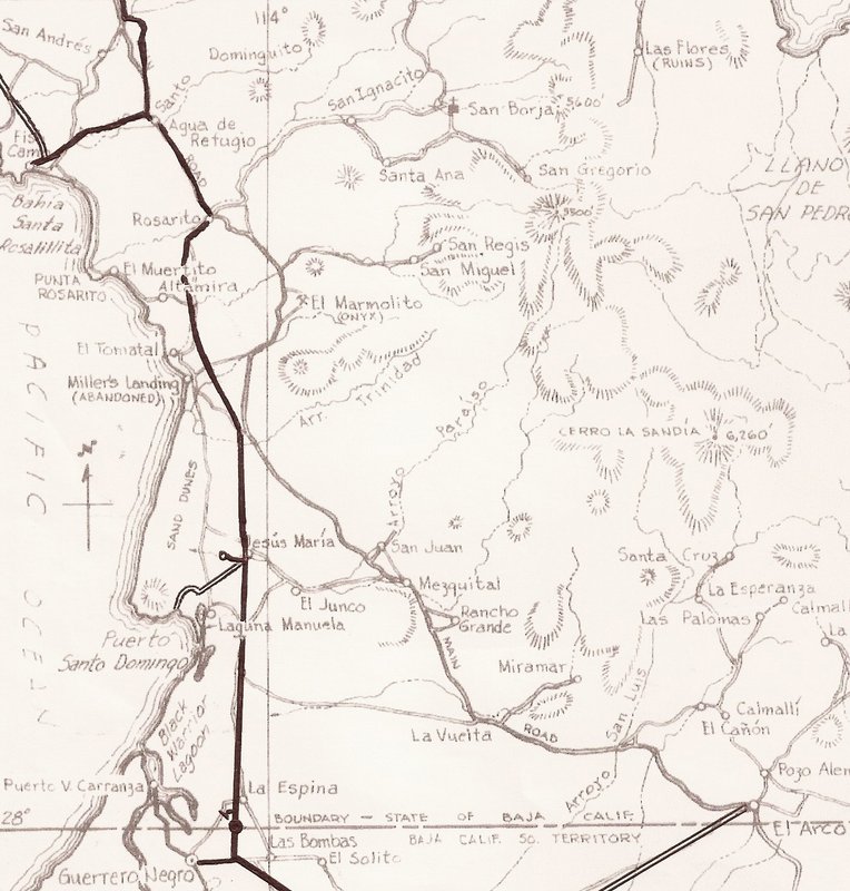
New Hwy. on 1962 Gulick Maps
OK, so here we have the four Gulick maps I drew in the new road(s) onto to compare. I did this several years ago, without advanced satellite mapping.
Today, maps (like the new Atlas and latest INEGI topos) are near perfect with where the roads are and match up with satellite imagery.
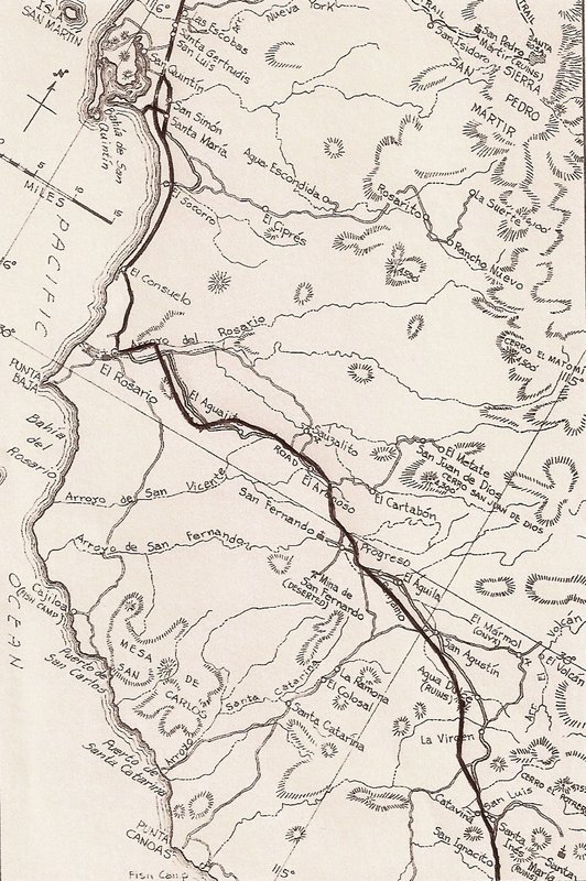

The other areas where Hwy. 1 differs from the old main road, is south of Concepción Bay. The old road to La Paz went through Comondú and the new
highway goes through Loreto.
South of La Paz, the new route is a little different as it passes Santiago and Miraflores, to the east. The old road when right through the center of
all the towns from Los Barriles to San José del Cabo.
|
|
|
David K
Honored Nomad
Posts: 65501
Registered: 8-30-2002
Location: San Diego County
Member Is Offline
Mood: Have Baja Fever
|
|
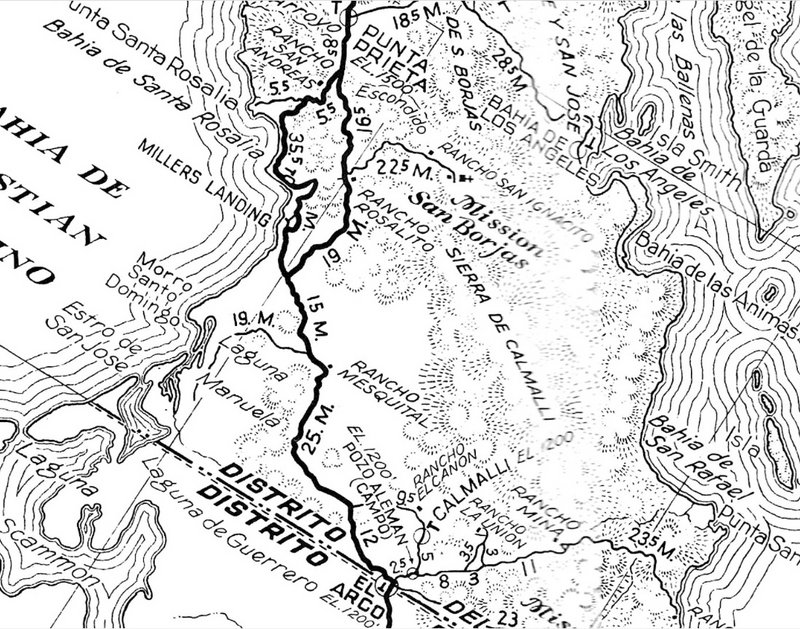
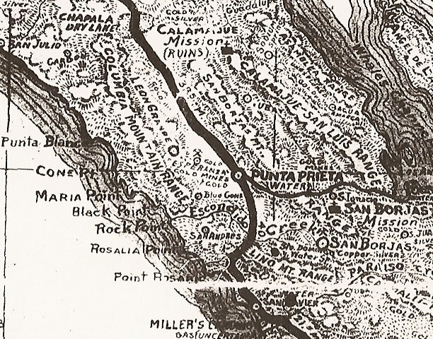
Homer Aschmann created this map to illustrate the changes in the transpeninsular road...

|
|
|
David K
Honored Nomad
Posts: 65501
Registered: 8-30-2002
Location: San Diego County
Member Is Offline
Mood: Have Baja Fever
|
|
Another change not shown by Homer's map, is south of Punta Prieta. The main route forked right to pass closer to the Pacific as far as Miller's
Landing (near El Tomatal). By the late 1950s, the more-inland road via Rosarito was the main road.
The 1955 Auto Club map gives equal status to both choices:
You might notice the mistake in the name Rosarito, and the original name for Punta and Bahía Santa Rosalillita...
Once more people were traveling into Baja, after WWII, in order to prevent confusion with the French copper mine and very large town of Santa
Rosalía, The 'other Santa Rosalía was changed to Little Santa Rosalía, or in Spanish, Rosalillita.
|
|
|
bajaric
Senior Nomad
Posts: 678
Registered: 2-2-2015
Member Is Offline
|
|
This is what happens if you ask DK for a map lol
The Punta Prieta-Santa Rosalillita (then called Santa Rosalia) road was a wagon road put in around 1900 to supply the mines around Punta Prieta, the
town. The mines were supplied by sea, because at that time the main north / south route in this area was El Camino Real between San Borja and
Calamajue, well to the east. "Hwy 1" did not yet exist.
Hale, traveling south towards Punta Prieta in 1921 saw a well graded "road to nowhere" going north from Punta Prieta. The road terminated abruptly in
the middle of the desert. This was probably the initial construction of what we call "Old Highway 1". This is the dirt road that parallels the new
paved Highway 1 (1973) just to the west of Parador Punta Prieta.
I took a drive on this section of old highway 1 a couple months ago. The road is actually in pretty good condition, considering it has been abandoned
for 50 years.
A couple of pictures: On the second Gulik map from the top, above, this is about at the "L" in Arroyo Leon. These are looking generally west, Mesa
el Leoncito and Sierra Columbia in background.
I had hope to go further west towards the Sierra Columbia but I was by myself, and it was pretty hot, and the road got pretty sketchy so turned
around. That is a bucket list destination for me but would be better to go with another vehicle in case someone got stuck. very remote area
Old Hwy 1 Sierra Columbia in background

Old Hwy 1 Mesa El Leoncito in background

[Edited on 2-2-2024 by bajaric]
|
|
|
100X
Nomad
Posts: 234
Registered: 11-3-2021
Member Is Offline
Mood: Thankful
|
|
Quote: Originally posted by bajaric  | This is what happens if you ask DK for a map lol
100X:
This stuff is pretty new to me and I find it very interesting. That the old main road used to go through Comondu amazes me.
Has anyone recently endeavored to follow the old road the entire peninsula? What a great trip that would be!
[Edited on 12-7-2021 by 100X] |
A life of fears leads to a death bed of regrets.
Find someone who will take care of you, and take care of them.
|
|
|
David K
Honored Nomad
Posts: 65501
Registered: 8-30-2002
Location: San Diego County
Member Is Offline
Mood: Have Baja Fever
|
|
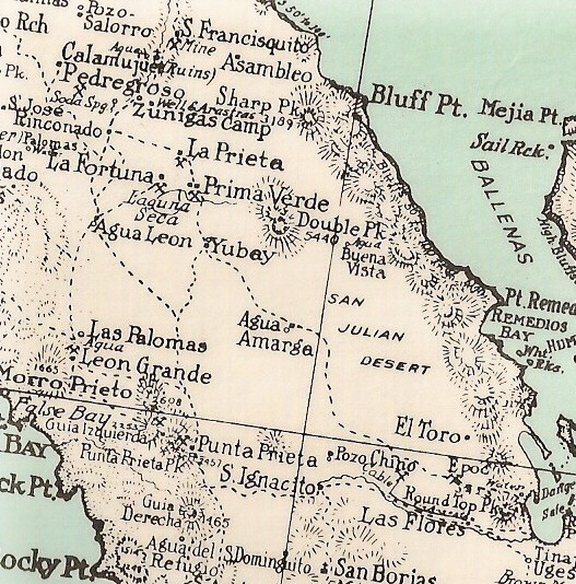
Have you been to Leon Grande, north of Punta Prieta and west of the transpeninsular roads (old and new)? You can see the road on Google Earth... but
cannot see much debris at the site, which is odd for such a well-mentioned mine camp. It is on all the maps from 1919-1941.
The 1941 Auto Road Map (heavy black line) shows Leon Grande and Esperanza gold mines, north of Punta Prieta (where the mill was).
|
|
|
bajaric
Senior Nomad
Posts: 678
Registered: 2-2-2015
Member Is Offline
|
|
That is where I was trying to go. Hale described the spring at Leon Grande as near the end of a road that went east towards BOLA, on the eastern edge
of the Sierra Columbia.
Maybe we should just go over there and have a look!
100x, the sections of the "old road" that were replaced by the new paved Hwy in 1973 generally became impassable fairly soon due to getting washed out
and destroyed if no one maintained them. This section of Old Highway 1 is an exception, probably because it is on a mesa and the area sees very little
rainfall.
[Edited on 12-8-2021 by bajaric]
[Edited on 12-8-2021 by bajaric]
|
|
|
David K
Honored Nomad
Posts: 65501
Registered: 8-30-2002
Location: San Diego County
Member Is Offline
Mood: Have Baja Fever
|
|
Hi Ric,
I wish I was traveling with you to search for Leon Grande!
My map showing Leon Grande has a question mark by it... since I was not there or could detect any surface ruins of a mine.
I did place it where the 1971 Geology map puts it and that seemed to be at the end of the dirt road going northward from the village of Punta Prieta
(at the end of the short paved exit from Hwy. 1).
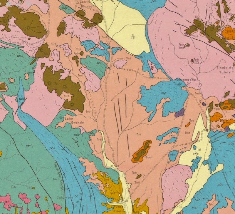
On the 1971 map portion here, I have Punta Prieta at the bottom, Desengaño shown, Yubay at the upper right edge, El Crucero (the junction of the gulf
road) and Cerrito Blanco at the top, and Los Cordonices (San Antonio) at the upper left.
The dirt roads of 1971 are there, including where you drove. I have found this map pretty accurate in other areas.
|
|
|
David K
Honored Nomad
Posts: 65501
Registered: 8-30-2002
Location: San Diego County
Member Is Offline
Mood: Have Baja Fever
|
|
| Quote: Originally posted by bajaric | | crossed posts. Well, maybe someday amigo. Bear in mind there are two "Leon Grandes", the spring, and the mine, and they may be some distance apart.
|
Is the spring 'Agua Leon' what you are thinking of? Harald has been playing with its location, I recall?
Maps seem to show it east of Codornices and apears it is south of the auto road... I found no road to it... but just looking casually.
The Goldbaum 1919 map (link on VivaBaja.com) is what Hale had and it shows Agua Leon and Leon Grande... https://collections.lib.uwm.edu/digital/collection/agdm/id/3...
1930 Map has a lot of content, some not placed well. However, Agua Leon is also shown west of Yubay, as on other maps:
[Edited on 12-7-2021 by David K]
|
|
|
4x4abc
Ultra Nomad
Posts: 4455
Registered: 4-24-2009
Location: La Paz, BCS
Member Is Offline
Mood: happy - always
|
|
where do I find Mina El Venado?
Harald Pietschmann
|
|
|
4x4abc
Ultra Nomad
Posts: 4455
Registered: 4-24-2009
Location: La Paz, BCS
Member Is Offline
Mood: happy - always
|
|
looks right
Harald Pietschmann
|
|
|
4x4abc
Ultra Nomad
Posts: 4455
Registered: 4-24-2009
Location: La Paz, BCS
Member Is Offline
Mood: happy - always
|
|
where do I find Mina El Venado?
Harald Pietschmann
|
|
|
bajaric
Senior Nomad
Posts: 678
Registered: 2-2-2015
Member Is Offline
|
|
29°01'46"N 114°15'15"W Mina El Venaado, the deer
[Edited on 12-9-2021 by bajaric]
|
|
|
4x4abc
Ultra Nomad
Posts: 4455
Registered: 4-24-2009
Location: La Paz, BCS
Member Is Offline
Mood: happy - always
|
|
Mina El Venado seems to be Mina Leon Grande
here is what I have:
Manantial Agua Leon 29°10'12.62”N, 114°13'45.36"W with road going east
Manantial Las Palomas - Leon Grande 29° 2'37.73”N, 114°16'35.62"W
Manantial (Las Palomas?) 29° 3'40.34”N, 114°17'11.69"W with road going east
Mina Leon Grande 29° 1'43.06”N, 114°15'17.44"W
Mina S/N 29° 1'41.36”N, 114°12'23.34"W
Mina S/N 28°53'51.50”N, 114°15'4.64"W
Mina Colombia 28°56'4.73”N, 114°14'44.87"W
Manantial 29° 6'18.19”N, 114°15'11.12"W
Manantial 29° 7'19.94”N, 114°15'29.47"W
Manantial (Las Palomas?) 29° 8'36.12”N, 114°12'46.79"W
Manantial 29° 9'37.58”N, 114°14'21.14"W
Manantial 29° 9'30.66”N. 114°14'24.83"W
Pozo 29°12'43.45”N, 114°16'9.77"W
Manantial Codornices 29°11'14.51”N, 114°18'1.97"W
[Edited on 12-9-2021 by 4x4abc]
Harald Pietschmann
|
|
|
David K
Honored Nomad
Posts: 65501
Registered: 8-30-2002
Location: San Diego County
Member Is Offline
Mood: Have Baja Fever
|
|
Mina = mine
Manantial = Water spring
Pozo = water well
I feel a map is in the works, so Nomads can see where these points are on a single map, without using Google satellite for each one!
|
|
|
4x4abc
Ultra Nomad
Posts: 4455
Registered: 4-24-2009
Location: La Paz, BCS
Member Is Offline
Mood: happy - always
|
|
I have 15 Kilometers between Mina Leon Grande and Agua Leon
3 kilometers between Mina Leon Grande and Agua Las Palomas
both as the crow flies
Harald Pietschmann
|
|
|
| Pages:
1
2
3 |


