| Pages:
1
2
3
..
5 |
Fatboy
Senior Nomad

Posts: 711
Registered: 6-28-2005
Member Is Offline
|
|
Hiking from Santa Gertrudis to San Borja - Advice wanted
Hi Everyone!
Planning a hike along the Camino Real between Santa Gertrudis and San Borja missions.
This has been on my bucket list for some time now and keeps getting bumped for various reasons.
Been to San Borja several times and we have done some hiking before but have some questions and looking for advice.
Does anyone know the the hiking distance? I know as the crow flies it is right at 45 miles.
Does anyone know of any permanent water sources along the way?
I am assuming parking at San Borja would be fairly safe, what about around Santa Gertrudis?
Getting from one end to the other either involves either 2 vehicles or a shuttle. Anyone open to shuttling us, or know someone who would, for a fee
of course?
Hoping to do this hiking sometime between 12/28/21 to 1/10/22.
Been to Viva Baja and got some info from David's site and have the KML file with waypoints from CaminoRealBaja.com.
Any advice or pointers would be greatly appreciated.
|
|
|
David K
Honored Nomad
Posts: 64478
Registered: 8-30-2002
Location: San Diego County
Member Is Offline
Mood: Have Baja Fever
|
|
Good to see you back here!
How about emailing Kevin (CaminoRealBaja) and chat with him about the trail details?
He can tell you about the tinajas or ranches where water can be obtained.
Feel free to contact me directly if I can assist!
|
|
|
Fatboy
Senior Nomad
Posts: 711
Registered: 6-28-2005
Member Is Offline
|
|
hmmmm, never thought about that! I will send him an email at see what comes of it.
I check in ever so often here but have not post in some time...have not been south of the border in a few years.
|
|
|
nandopedal
Nomad
Posts: 167
Registered: 6-1-2010
Location: San Diego Ca
Member Is Offline
Mood: Negra Modelo
|
|
Sounds like a good hike, hey simple curiosity question, how do you get 45 miles distance? a straight line on google maps shows 62.7 miles. At any rate
good luck and take lots of pictures!
\"There are many dangers in Baja. The most serious of which is not going.\" Christophe Noel (EXPO)
|
|
|
advrider
Super Nomad
Posts: 1847
Registered: 10-2-2015
Member Is Offline
|
|
Please post any detail you come up with, also a trip report if you are able to make it happen. I would love to make that hike as well, but I can't
until next year. If you want to do it a second time I would be in for sure.
|
|
|
Fatboy
Senior Nomad
Posts: 711
Registered: 6-28-2005
Member Is Offline
|
|
Quote: Originally posted by nandopedal  | | Sounds like a good hike, hey simple curiosity question, how do you get 45 miles distance? a straight line on google maps shows 62.7 miles. At any rate
good luck and take lots of pictures! |
Well,was having trouble with Google Darth... Thanks for pointing that out.
|
|
|
David K
Honored Nomad
Posts: 64478
Registered: 8-30-2002
Location: San Diego County
Member Is Offline
Mood: Have Baja Fever
|
|
The padres wrote it was a three-day journey from Santa Gertrudis to San Borja. These were tough men and often started before sunrise.
The ECR is depicted on the Benchmark atlas and maps I made as well as geoffff...
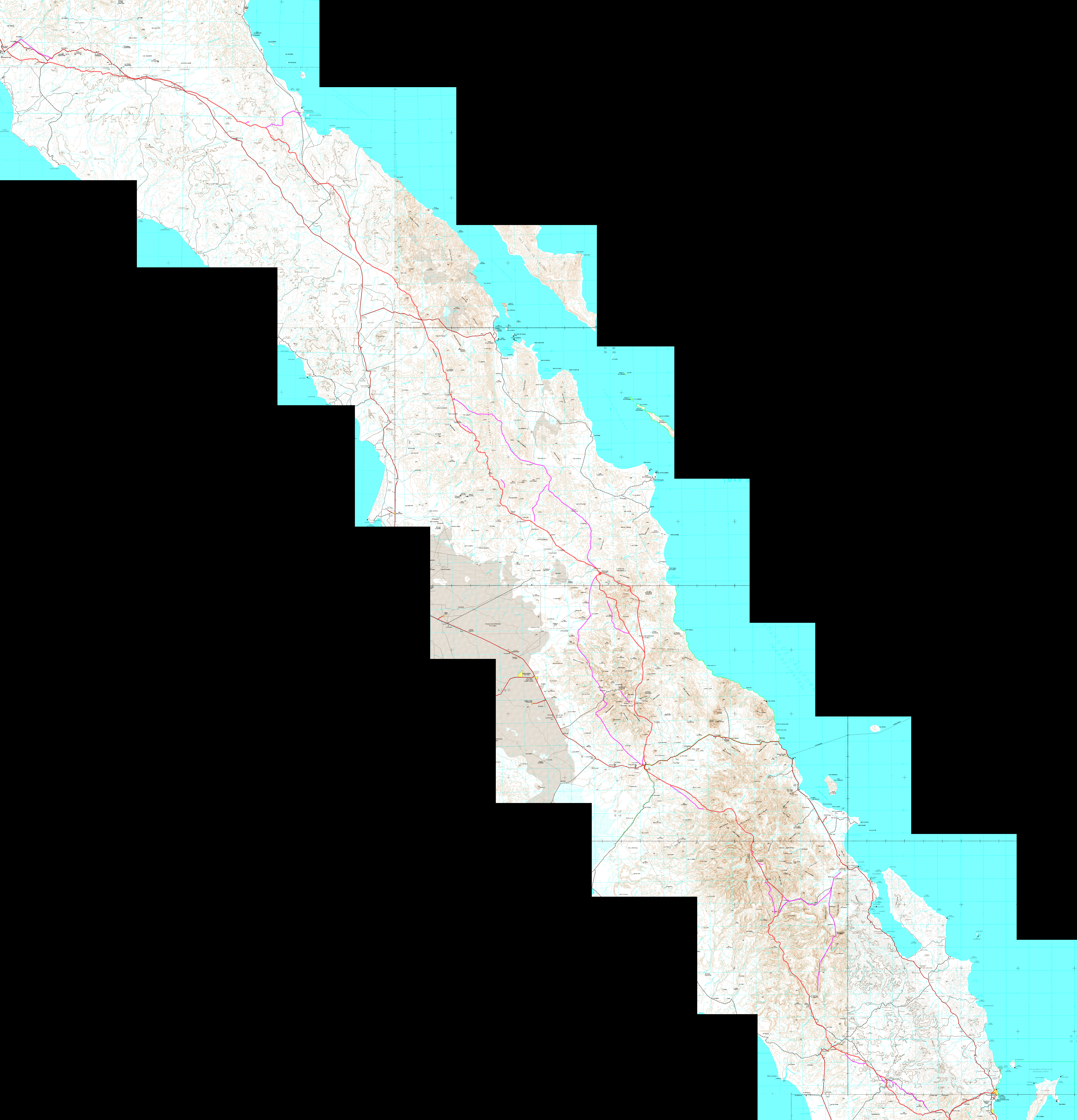
On my website, at the link called "Finding El Camino Real" are both old and new maps showing the trail: http://www.vivabaja.com/HGREAL.html
The trail location on the two newest map links is verified by the team at www.caminorealbaja.com
Click the link to open in maximum detail. Loreto to El Rosario:
https://octopup.org/img/misc/davidk/ecr/caminorealbaja-com-t...
Reduced to fit on Nomad:
|
|
|
geoffff
Senior Nomad
Posts: 643
Registered: 1-15-2009
Member Is Offline
|
|
Here is my crude map attempt! click to enlarge.
I also measure about 60 miles as the crow flies.

|
|
|
David K
Honored Nomad
Posts: 64478
Registered: 8-30-2002
Location: San Diego County
Member Is Offline
Mood: Have Baja Fever
|
|
Nice, as we can see, there was not just one El Camino Real between missions. The Benchmark Atlas has the Camino Real trails, as researched by www.caminorealbaja.com
|
|
|
Fatboy
Senior Nomad
Posts: 711
Registered: 6-28-2005
Member Is Offline
|
|
| Quote: Originally posted by advrider | | Please post any detail you come up with, also a trip report if you are able to make it happen. I would love to make that hike as well, but I can't
until next year. If you want to do it a second time I would be in for sure. |
Also looking to do from San Gretudis south at some point, when would you be interested in doing a section?
|
|
|
4x4abc
Ultra Nomad
Posts: 4163
Registered: 4-24-2009
Location: La Paz, BCS
Member Is Offline
Mood: happy - always
|
|
Edie Littlefield probably has the best first hand information on that section
Harald Pietschmann
|
|
|
Fatboy
Senior Nomad
Posts: 711
Registered: 6-28-2005
Member Is Offline
|
|
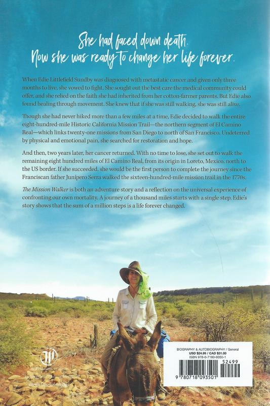
Edie.... Did she write The Mission Walker?
Geoff...cool map, Thanks.
David, it is interesting all the 'side' routes to the ECR that there are.
3 days? That is pretty good since it appears to be 70 miles or more on the ground.
|
|
|
David K
Honored Nomad
Posts: 64478
Registered: 8-30-2002
Location: San Diego County
Member Is Offline
Mood: Have Baja Fever
|
|


Edie with Max Kurillo and I, a couple years ago.
|
|
|
Fatboy
Senior Nomad
Posts: 711
Registered: 6-28-2005
Member Is Offline
|
|
That is what I thought, her book is ordered and should be here in a few days!
|
|
|
David K
Honored Nomad
Posts: 64478
Registered: 8-30-2002
Location: San Diego County
Member Is Offline
Mood: Have Baja Fever
|
|
She was guided by locals, some were arranged by Trudi Angell, and was not always on the Camino Real but her story of surviving cancer is very intense!
Her Facebook page: https://www.facebook.com/profile.php?id=636708426
Edie is or was walking across America... More on her other page: https://www.facebook.com/themissionwalker
|
|
|
TMW
Select Nomad
Posts: 10659
Registered: 9-1-2003
Location: Bakersfield, CA
Member Is Offline
|
|
Fatboy there are some people that walked the ECR and did a website and marked all the way points. It would also be a good place to check out. I think
they also marked the water sources.
http://caminorealbaja.com/
|
|
|
Fatboy
Senior Nomad
Posts: 711
Registered: 6-28-2005
Member Is Offline
|
|
Thanks TMW.
That is a go to site for location and they did a lot work to post all the waypoints and notes that they did. Even with all that there is little actual
detail.
My biggest concerns are water sources and parking and shuttling from end to end.
What I am hearing is it will be a 3 to 5 day journey and there are a few spots they marked as H2O. Just wonder are they reliable year round water
sources or seasonal?
|
|
|
advrider
Super Nomad
Posts: 1847
Registered: 10-2-2015
Member Is Offline
|
|
| Quote: Originally posted by Fatboy | | Quote: Originally posted by advrider | | Please post any detail you come up with, also a trip report if you are able to make it happen. I would love to make that hike as well, but I can't
until next year. If you want to do it a second time I would be in for sure. |
Also looking to do from San Gretudis south at some point, when would you be interested in doing a section? |
I would for sure. I start the PCT March 17th 2021, doing the whole 2653 miles in one shot, hope to be done by September. After that I will be all in
for any Baja hikes. I would figure about fifteen miles a day depending on how rocky it is, maybe more depending on water and heat. I'm sure my wife or
others I know can help with running a shuttle. Water would be the big issue for sure.
[Edited on 11-1-2021 by advrider]
|
|
|
David K
Honored Nomad
Posts: 64478
Registered: 8-30-2002
Location: San Diego County
Member Is Offline
Mood: Have Baja Fever
|
|
That is rough county, so 15 miles is probably a good estimate. Having a burro to carry water and gear may be wise, too?
Hoping to have some El Camino Real trail data, I had to refresh my memory of the route used by Graham and Misión (his burro) in the 1997 'Journey
with a Baja Burro' (published at the end of 2000, as a 2001 book). Alas, Graham stayed to auto roads and went west to Rosarito from San Borja.
Let's see what Harry Crosby, on muleback, 25 years before Graham says... (to be continued)
Crosby's maps:

1974
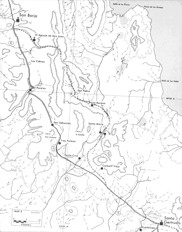
1977
|
|
|
Fatboy
Senior Nomad
Posts: 711
Registered: 6-28-2005
Member Is Offline
|
|
| Quote: Originally posted by advrider |
I would for sure. I start the PCT March 17th 2021, doing the whole 2653 miles in one shot, hope to be done by September. After that I will be all in
for any Baja hikes. I would figure about fifteen miles a day depending on how rocky it is, maybe more depending on water and heat. I'm sure my wife or
others I know can help with running a shuttle. Water would be the big issue for sure.
[Edited on 11-1-2021 by advrider] |
Hope the PCT trip is enjoyable, a baja post trip hike can help keep the after trail blues away.
[Edited on 11-2-2021 by Fatboy]
|
|
|
| Pages:
1
2
3
..
5 |


