| Pages:
1
2
3
4
5 |
Fatboy
Senior Nomad

Posts: 714
Registered: 6-28-2005
Member Is Offline
|
|
Quote: Originally posted by David K  | That is rough county, so 15 miles is probably a good estimate. Having a burro to carry water and gear may be wise, too?
Hoping to have some El Camino Real trail data, I had to refresh my memory of the route used by Graham and Misión (his burro) in the 1997 'Journey
with a Baja Burro' (published at the end of 2000, as a 2001 book). Alas, Graham stayed to auto roads and went west to Rosarito from San Borja.
Let's see what Harry Crosby, on muleback, 25 years before Graham says... (to be continued)
|
Was wondering about Crosby's route, seems to all be about the same routes, which is good!
|
|
|
mtgoat666
Select Nomad
Posts: 17326
Registered: 9-16-2006
Location: San Diego
Member Is Offline
Mood: Hot n spicy
|
|
| Quote: Originally posted by Fatboy |
Thanks TMW.
That is a go to site for location and they did a lot work to post all the waypoints and notes that they did. Even with all that there is little actual
detail.
My biggest concerns are water sources and parking and shuttling from end to end.
What I am hearing is it will be a 3 to 5 day journey and there are a few spots they marked as H2O. Just wonder are they reliable year round water
sources or seasonal? |
Talk to local ranchers to get info on water sources in their range areas. Perhaps spend a few days driving into or walking into a few ranches to
inquire.
I doubt you will find any gringo or Internet forum sources for this area. rare for gringos to hike that part of baja for more than just a short day
hike from the road.
Woke!
“...ask not what your country can do for you – ask what you can do for your country.” “My fellow citizens of the world: ask not what America
will do for you, but what together we can do for the freedom of man.”
Prefered gender pronoun: the royal we
|
|
|
TMW
Select Nomad
Posts: 10659
Registered: 9-1-2003
Location: Bakersfield, CA
Member Is Offline
|
|
Fatboy I am willing help and I have a friend or two that may help too. I have a 2004 Tacoma 4x4 with a shell so throw what you need into it and away
we go. Just need to work out where to meet. let me know as we get closer.
|
|
|
Fatboy
Senior Nomad
Posts: 714
Registered: 6-28-2005
Member Is Offline
|
|
Thanks, TMW!
|
|
|
David K
Honored Nomad
Posts: 64486
Registered: 8-30-2002
Location: San Diego County
Member Is Offline
Mood: Have Baja Fever
|
|
Nomad search for Paraiso on El Camino Real
| Quote: Originally posted by mtgoat666 | | Quote: Originally posted by Fatboy |
Thanks TMW.
That is a go to site for location and they did a lot work to post all the waypoints and notes that they did. Even with all that there is little actual
detail.
My biggest concerns are water sources and parking and shuttling from end to end.
What I am hearing is it will be a 3 to 5 day journey and there are a few spots they marked as H2O. Just wonder are they reliable year round water
sources or seasonal? |
Talk to local ranchers to get info on water sources in their range areas. Perhaps spend a few days driving into or walking into a few ranches to
inquire.
I doubt you will find any gringo or Internet forum sources for this area. rare for gringos to hike that part of baja for more than just a short day
hike from the road.
|
Again, so very wrong.
Our own mule-riding Nomad, Baja Bucko, has been riding El Camino Real since I met her in 2001.
Harry Crosby's excellent historical journey book, The King's Highway in Baja California, details the difficulty of this section of the mission road.
In particular, El Paraiso, a 1,200 foot deep canyon that the Camino Real drops down to and back up from.
Baja Bucko wrote about her friend falling here and had to be extracted... Maybe search Nomad for the story? Found it in May 2005...
In Feb. 2009:
| Quote: Originally posted by Baja Bucko | I think I've ridden (mules) and a little bit backpacking- (that when I was a hippie in 1972) abt 90% of ECR from El Rosario to Loreto. Yes there are
places where modern roads overlay places but for the most part this "road" was never intended for wheels and by 1900 the "main" path of travel was
leaving El Camino Real for easier routes. There is the absolutely fascinating feeling to struggle and climb ( and pray that the mule stays
upright!!!) and mule feet picking back and forth up and down cuestas only to find at the top of a mesa a perfectly-cleared rock-lined "road" I could
drive a minivan on-for a 100 feet or so and then wham! back to the miles of worse-than-a-goat-trail to head down incredible rocky steep (reminiscing
El Paraiso!!) and feel so gleeful that I lived to tell the tale! After every trip even wearing "armor" I still have spines popping out of me for
months.
I have recvd many emails from people just thinking that hay-let's just backpack it and they have no clue that you need a local vaquero (he always
knows when & where the water is this year) and when the trail becomes split in several same but not directions due to different uses at different
times over the past 300 years-taking the WRONG path can get you dead or found wandering as dehydrated lion bait. Granted GPS has opened up a new
world but its a lot of big country down there and there aren't forest service signs telling you how far it is to the next waterhole or THAT part of
the trail is totally impassable 2 hours from where you are standing. ECR is NOT a park service thing-for the most part it is very wild country with
many parts of the trails rarely seeing anyone except a cowboy every couple of years looking for cows or goats.
Last year I was sitting at a table sharing lunch with Harry Crosby and I toasted him and made it clear to his wife and all present-it was HIS FAULT
that I was horribly addicted to Baja California and El Camino Real. I think he got a kick out of that!!! |
In May 2013:
| Quote: Originally posted by Baja Bucko | I have ridden (mule) El Infierno many times in the SSF and much of ECR in this range, also all of it from San Casimero north to almost El Rosario;
south of Ian Ignacio from Guajademi to San Javier.
I don't have time at this moment but will try to get back regarding many questions here. By far with the problems age, lack of use and chubascos
bring, El Paraiso is one of the worst parts.......(Sta Gertrudis to San Borja)....even Harry had a hiccup or two there. |
In June 2016, I wrote an article about El Camino Real Cuestas (switchback grades): https://www.bajabound.com/bajaadventures/bajatravel/cuestas_...
"The Paraíso Canyon was a 1,200’ plunge for El Camino Real that began at 28⁰31.560’, -113⁰38.220’ (3,400’) and then a climb back out 2.3
miles up the canyon, past a ranch that began as a mission farm for San Borja, in the 1760s. Just two miles beyond the north rim of the canyon, El
Camino Real comes to Las Cabras where the Spanish first saw snow in California, at an elevation of 4,000 feet."
In 2008, I posted the route from San Borja south to Santa Gertrudis, using satellite images and Baja Almanac maps... ignore the Photobucket watermark:
http://forums.bajanomad.com/viewthread.php?tid=36002
In 2011:
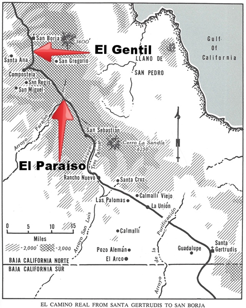
SANTA GERTRUDIS TO SAN BORJA
As in the previous section (San Ignacio to Santa Gertrudis), more than one trail was the Camino Real. This first description will be the route
traveled by Serra (probably) and Harry Crosby, known as the 'Paraiso route' by Howard Gulick.
The old camino goes straight northwest from Santa Gertrudis to RANCHO LA UNION then just west of MESA CALMALLI VIEJO and MESA SANTA CRUZ to RANCHO
TRES PALMAS.
The trail from Tres Palmas was sandy as it follows the ARROYO SAN SEBASTION (called Arroyo Tres Palmas by Crosby), but becomes rocky as it climbs up
the sierra to RANCHO SAN SEBASTION.
The Camino Real again climbs and goes through a pass just west of San Sebastion then follows the west edge of Arroyo San Sebastion on a mesa where
Crosby reports a grand view back to Scammon's Lagoon.
EL RANCHO is reached, seen on the edge of the map. EL RODEO is the next place mentioned by Crosby and the trail next reaches the edge of the great
canyon of ARROYO PARAISO.
The Camino Real was steep where it dropped off the mesa and required an hour of rock moving by Crosby and company to rebuild washed out portions. They
reached the bottom and traveled up the canyon to RANCHO EL PARAISO.
A quarter mile beyond Rancho El Paraiso is the grade to the top of the north side of the canyon. LAS CABRAS then COMPOSTELA are passed as this route
of the Camino Real goes north to reach MISION SAN BORJA.
-----------------------------------------------------------------------------
In May 2005, Neal Johns posted:
Baja Bucko's story:
On Easter Sunday I rode out of Mision Santa Gertrudis on El Camino Real for a 10 day journey back in time with the destination of Mision San Borja.
As we finished packing the animals and mounted up we had a crowd of Mexican holiday visitors watching the proceedings in amazement. The mules are
taking you where? A few came up and asked to take pictures. They could not believe that we were doing such a thing-after all you can drive there by
getting back on the highway and getting to the road up north! So here we were-gringos and the Mexican tourists were taking our pictures.
: Sort of funny if you think about it...then when the pack train finally arrived in San Borja-via the fun and harrowing excitement of the famed El
Paraiso-more Mexican cameras clicking away in disbelief. The civil engineer working at Mision San Borja absolutely could not believe that we arrived
by mule from Santa Gertrudis. He asked each of my friends "How did you get here?" and each friend said by mule from Santa Gertrudis. He refused to
believe them. Then when he asked me and I repeated their answers his eyes opened wide and his mouth dropped. He repeated the same question again and I
repeated my answer. Then he was silent. After a very very quiet minute or so he asked me "WHY?"
: I held my hand over my heart and I answered "Mi corazon" .......I explained that the ancient foot trails of El Camino Real were the real treasures
of Baja California as are the Californio families who have lived in that incredible country for over 250 years. He smiled and asked my age. I said
over 50. He nearly died in amazement again and said that as a young man he could do it but now at 35-he was too old.
: Life is way too short I told him and you've got to do what you dream while the body parts still function. He laughed. They took more pictures of the
dirty exhausted crazy gringos who arrived from so far with a bunch of tired pack animals, one human injury (excluding the zillions of espinas and cuts
and scrapes!) and tales to tell.
: PS When I finally got my injured friend to a hospital in San Diego-7 days after her fall from a horse in the dark as a loose pack mule flew into it
going down down down El Paraiso-the hospital people could NOT believe this person had to ride for 5 days w the hand and arm injury she had along with
the two day drive to San Diego. Oooh, but the ear-to-ear grin I had on my face looking like a real drunk because such are the tales and treasures of
that land that lies so dear to my soul.
---------------------------------------------------------------------------------------------------
In Feb. 2004:
EL CAMINO REAL in Baja (Part 7), Santa Gertrudis to San Borja
Baja Almanac pages 25, 23, 22:
As in the previous section (Sam Ignacio to Santa Gertrudis), more than one trail was the Camino Real. This first description will be the route
traveled by Serra (probably) and Harry Crosby, known as the 'Paraiso route' by Howard Gulick.
The old camino is shown in the Almanac as it goes straight northwest from Santa Gertrudis to RANCHO LA UNION then just west of MESA CALMALLI VIEJO and
MESA SANTA CRUZ to RANCHO TRES PALMAS.
The trail from Tres Palmas was sandy as it follows the ARROYO SAN SEBASTION (called Arroyo Tres Palmas by Crosby), but becomes rocky as it climbs up
the sierra to RANCHO SAN SEBASTION.
The Camino Real again climbs and goes through a pass just west of San Sebastion then follows the west edge of Arroyo San Sebastion on a mesa where
Crosby reports a grand view back to Scammon's Lagoon.
Now on Almanac page 22:
EL RANCHO is reached, seen on the edge of the map. EL RODEO is the next place mentioned by Crosby and is shown in the Almanac before the (shown) trail
reaches the edge of the great canyon of ARROYO PARAISO.
The Camino Real was steep where it dropped off the mesa and required an hour of rock moving by Crosby and company to rebuild washed out portions. They
reached the bottom and traveled up the canyon to RANCHO EL PARAISO.
A quarter mile beyond Rancho El Paraiso is the grade to the top of the north side of the canyon. LAS CABRAS then COMPOSTELA are passed as this route
of the Camino Real goes north to reach MISION SAN BORJA.
|
|
|
bajaric
Senior Nomad
Posts: 602
Registered: 2-2-2015
Member Is Offline
|
|
That is a very remote area! I would think that local knowledge of where water could be obtained would be essential, perhaps hire a guide?
One possible water source is San Sebastion. Gabb, in his account of traveling from San Ignacio to San Borja noted an abandoned prospecting camp with
an arrastra at San Sebastion, indicating there was water available. On the other hand, that was in 1867!
|
|
|
advrider
Super Nomad
Posts: 1847
Registered: 10-2-2015
Member Is Offline
|
|
I think a burro would be a good move for safety of having extra water. A guide would be a good bet as well, safer is better, its very remote. My
Spanish isn't good enough to gather much intel but visiting some local ranches would be a good move as well.
Very nice offer TMW, that would be a big help. This would be perfect trip to help recover from the PCT. Very interested in everyone's input and
knowledge.
|
|
|
David K
Honored Nomad
Posts: 64486
Registered: 8-30-2002
Location: San Diego County
Member Is Offline
Mood: Have Baja Fever
|
|
For sure, a mountain-ranch guide would be essential to guaranteed success.
Because none of them are on Baja Nomad, we can help Fatboy with the data we have here. I will send Baja Bucko and email and see if she would like to
add anything.
|
|
|
bajaric
Senior Nomad
Posts: 602
Registered: 2-2-2015
Member Is Offline
|
|
There was water at regular intervals along the trail back in missionary times. The question is, are these water sources still there or have they
dried up?
I guess you could just wing it and carry enough water to get to the next water hole, plus enough to turn around and go back where you started in case
it was dry. GPS track, inreach, etc so you did not get lost, water in multiple containers in case one leaks.
Me, I like a truck full of gear, ice chests, a comfy bed, and little short day hikes.
edit Gabb's account of the trail from Santa Getrudis to San Borja is included in J. Ross Browne s epic "Resources of the Pacific Slope" on page # 855
pg. 103-105 search babel.hathitrust. org
Water was found at Calmalli Viejo, San Sebastion, and "Agua de la Cabra" along the route. Gabb said there was a 20 miles gap without water between
Calmalli Viejo and San Sebastion, in 1867.
[Edited on 11-2-2021 by bajaric]
|
|
|
David K
Honored Nomad
Posts: 64486
Registered: 8-30-2002
Location: San Diego County
Member Is Offline
Mood: Have Baja Fever
|
|
| Quote: Originally posted by bajaric | There was water at regular intervals along the trail back in missionary times. The question is, are these water sources still there or have they
dried up?
I guess you could just wing it and carry enough water to get to the next water hole, plus enough to turn around and go back where you started in case
it was dry. GPS track, inreach, etc so you did not get lost, water in multiple containers in case one leaks. But you knew all that already, eh
fatboy, from the epic fat bike expedition to Salispudes.
Me, I like a truck full of gear, ice chests, a comfy bed, and little short day hikes. |
  ya, I
think I am in that category too! I really hope Fatboy can do this as it will be very exciting to follow. If he wishes me to, I will again post his
updates and map locations... and if not, I will alert all if he needs assistance... just like others with inReach or Spot devices who have me in their
contacts. ya, I
think I am in that category too! I really hope Fatboy can do this as it will be very exciting to follow. If he wishes me to, I will again post his
updates and map locations... and if not, I will alert all if he needs assistance... just like others with inReach or Spot devices who have me in their
contacts.
|
|
|
Paulina
Ultra Nomad
Posts: 3810
Registered: 8-31-2002
Location: BCN
Member Is Offline
|
|
This has been an interesting thread to read along with, thanks David for sharing your input. I will be riding from Rancho San Gregorio up to Mina San
Juan in a couple of weeks. I also have planned to ride some of the Camino Real after working radio relay up on the mountain top for BFG.
I have ridden much of the range surrounding San Borja and RSG in the past three years, helping with the cattle round up. The vaqueros knew where the
springs were located, where to refill canteens. I drink the ranch water without an issue, but was cautioned not to drink from the water out on the
range.
Fatboy, if you are open to having a guide I can ask my friend from RSG if he would be interested or maybe know someone who would. I can imagine the
questions he might have such as compensation for the guide, do you speak Spanish, would you need pack animal(s) or are you planning to pack your own
supplies, water, food, emergency locator, sat phone, transportation from your desitnation back to San Borja and if pack animals are used, will you
arrange for transportation of the animal with the guide? That's just a few off of the top of my head.
Feel free to u2u me.
P>*)))>{
\"Well behaved women rarely make history.\" Laurel Thatcher Ulrich
|
|
|
4x4abc
Ultra Nomad
Posts: 4165
Registered: 4-24-2009
Location: La Paz, BCS
Member Is Offline
Mood: happy - always
|
|
I have a database of all water sources and all branches of Camino Real in the area
you are welcome to have them
HOWEVER, I would highly recommend hiring local guides to steer you to the water sources that actually have water when you are on your way.
Harald Pietschmann
|
|
|
Paulina
Ultra Nomad
Posts: 3810
Registered: 8-31-2002
Location: BCN
Member Is Offline
|
|
| Quote: Originally posted by 4x4abc | I have a database of all water sources and all branches of Camino Real in the area
you are welcome to have them
HOWEVER, I would highly recommend hiring local guides to steer you to the water sources that actually have water when you are on your way.
|
"...that actually have water..."
Good point. Water isn't a guarantee. There has been very little rain, a drought that has killed most of the free range livestock.
P>*)))>{
\"Well behaved women rarely make history.\" Laurel Thatcher Ulrich
|
|
|
advrider
Super Nomad
Posts: 1847
Registered: 10-2-2015
Member Is Offline
|
|
This is fatboys gig but I am very interested in the hike as well and possible share recourses and costs? With water being 8 3/4 pounds per gallons
its not practical to pack more then 7-8 liters unless you have an animal. With cool temps you are looking at 1-liter per 5 miles, more if it's very
rocky.
Could be a small margin for error if you miss a water source and have to burn time and energy looking for it. A guide would be a huge safety net.
Anyone else looking to do some hiking in Baja please let me know if you want company, or send me a U2U..
|
|
|
Fatboy
Senior Nomad
Posts: 714
Registered: 6-28-2005
Member Is Offline
|
|
| Quote: Originally posted by David K | That is rough county, so 15 miles is probably a good estimate. Having a burro to carry water and gear may be wise, too?
|
Well I am going to have my daughter along.....
|
|
|
Fatboy
Senior Nomad
Posts: 714
Registered: 6-28-2005
Member Is Offline
|
|
| Quote: Originally posted by mtgoat666 |
Talk to local ranchers to get info on water sources in their range areas. Perhaps spend a few days driving into or walking into a few ranches to
inquire.
I doubt you will find any gringo or Internet forum sources for this area. rare for gringos to hike that part of baja for more than just a short day
hike from the road.
|
Your right Mtgoat, I should do more than some internet search and the locals will know their areas very well. Bad part is I won't have the time and
even worse is it isn't my style  . .
Going to do what I usually do on these trips and just wing it, and one of these days it is going come back and smack me....
I remember wanting to kayak the Rio Grande river in Big Bend, but you have to have permits to do it. We went to the ranger station and the ranger
wanted to know how skilled we were. All I could do is shrug because it isn't like there is standard test for this kinda stuff.
All I could do is rattle off what we have done in the past, and before I finished he interrupted me and said we well be fine.
I sort of treat hiking like that and the hikes are get pretty rough and remote now and some day I will misjudge something seriously and there will be
consequences...
[Edited on 11-3-2021 by Fatboy]
|
|
|
Fatboy
Senior Nomad
Posts: 714
Registered: 6-28-2005
Member Is Offline
|
|
Well, I read David's, Paulina's and the others AFTER my post to Mtgoat. Again, this is still in the planning stages. My spanish is nil, a few words
really. Am I against a local guide? No, but I am certainly not for one either.
I have read about Paraiso already and was pondering that challenge too.
I have done some very remote desert hiking in Utah with only a few known water sources over many square miles, and as noted water is heavy and you can
only pack so much.
Up on the Kairparowits Plateau in July with only 1 water source It is easy to find the limits of what a person can, or worse, cannot do. No trails, no
back up water source, no help, in 105 degree weather with just the water I could carry and covering almost 30 miles it made me wonder just how stupid
I am.
Well, the research goes on.
[Edited on 11-3-2021 by Fatboy]
|
|
|
advrider
Super Nomad
Posts: 1847
Registered: 10-2-2015
Member Is Offline
|
|
Fatboy, I like your style! Hope to hike with you next year. Maybe re-hike that route if you do it this year or find something new? Good luck and I
will be following along.
|
|
|
4x4abc
Ultra Nomad
Posts: 4165
Registered: 4-24-2009
Location: La Paz, BCS
Member Is Offline
Mood: happy - always
|
|
I am lost
you want to wing it
you want no assistance
why exactly are you posting?
Harald Pietschmann
|
|
|
Fatboy
Senior Nomad
Posts: 714
Registered: 6-28-2005
Member Is Offline
|
|

I want BETA on a trail, not a guide. Big difference between ASSISTANCE and ADVICE.
I am asking for info on the trail, not to be guided down the trail.
By 'winging it' I mean get as much data/beta/advice on the trail ahead of time, then making a decision to go/not go.
If I wanted a guide I would have started the thread with LOOKING FOR GUIDE.... 
Now, those water sources you have documented  see my U2 see my U2
[Edited on 11-3-2021 by Fatboy]
|
|
|
| Pages:
1
2
3
4
5 |


