| Pages:
1
2 |
4x4abc
Ultra Nomad

Posts: 4165
Registered: 4-24-2009
Location: La Paz, BCS
Member Is Offline
Mood: happy - always
|
|
I am happy
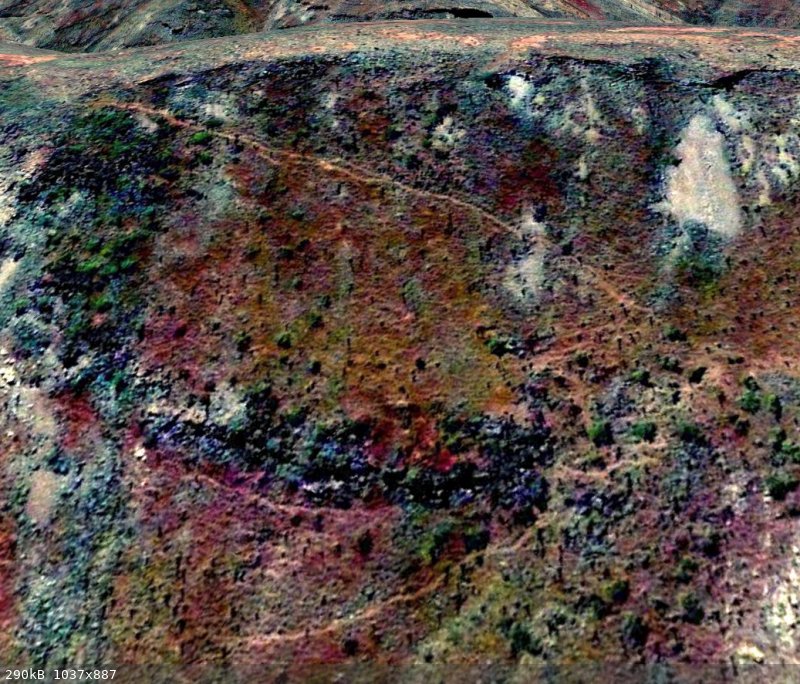
I was just about to close down for the night - then this line caught my eye
a new trail
no idea yet what it is good for
but it looks well used
Harald Pietschmann
|
|
|
Glidergeek
Nomad
Posts: 110
Registered: 9-22-2014
Location: Hesperia Ca
Member Is Offline
Mood: Moody
|
|
Game trail?
|
|
|
4x4abc
Ultra Nomad
Posts: 4165
Registered: 4-24-2009
Location: La Paz, BCS
Member Is Offline
Mood: happy - always
|
|
looks like it is not connected to anything anywhere
it can be traced for a while on top of a mesa
does not pick up after that
too bad
Harald Pietschmann
|
|
|
AKgringo
Elite Nomad
Posts: 5815
Registered: 9-20-2014
Location: Anchorage, AK (no mas!)
Member Is Offline
Mood: Retireded
|
|
Maybe "game trails" maintained by livestock? I see a whole lot more cattle and goats than deer or wild burros!
If you are not living on the edge, you are taking up too much space!
"Could do better if he tried!" Report card comments from most of my grade school teachers. Sadly, still true!
|
|
|
4x4abc
Ultra Nomad
Posts: 4165
Registered: 4-24-2009
Location: La Paz, BCS
Member Is Offline
Mood: happy - always
|
|
cattle is definitely a driving force
I love the areas of Baja where you don't have goat or cow.
Plants look different
ground looks different
NoWimp trail is ne of those areas
not enough water to ranch
Harald Pietschmann
|
|
|
wilderone
Ultra Nomad
Posts: 3779
Registered: 2-9-2004
Member Is Offline
|
|
Where is it? Do you compare with the Baja Topo Atlas? The very far left side of the photo shows some corral looking or cleared areas surrounded by
something. Might be a ranch with roads going to it.
|
|
|
4x4abc
Ultra Nomad
Posts: 4165
Registered: 4-24-2009
Location: La Paz, BCS
Member Is Offline
Mood: happy - always
|
|
no Corral or Rancho nearby
but I have been studying it over the weekend and it looks like it is part of a trail network tying into Cuesta Paraiso
there is even a benchmark close by, indicating strong human interest
Topo Atlas and INEGI map sheets do not offer any help (except the benchmark notice)
Harald Pietschmann
|
|
|
4x4abc
Ultra Nomad
Posts: 4165
Registered: 4-24-2009
Location: La Paz, BCS
Member Is Offline
Mood: happy - always
|
|
the newly found Cuesta here:

[Edited on 11-16-2021 by 4x4abc]
Harald Pietschmann
|
|
|
geoffff
Senior Nomad
Posts: 643
Registered: 1-15-2009
Member Is Offline
|
|
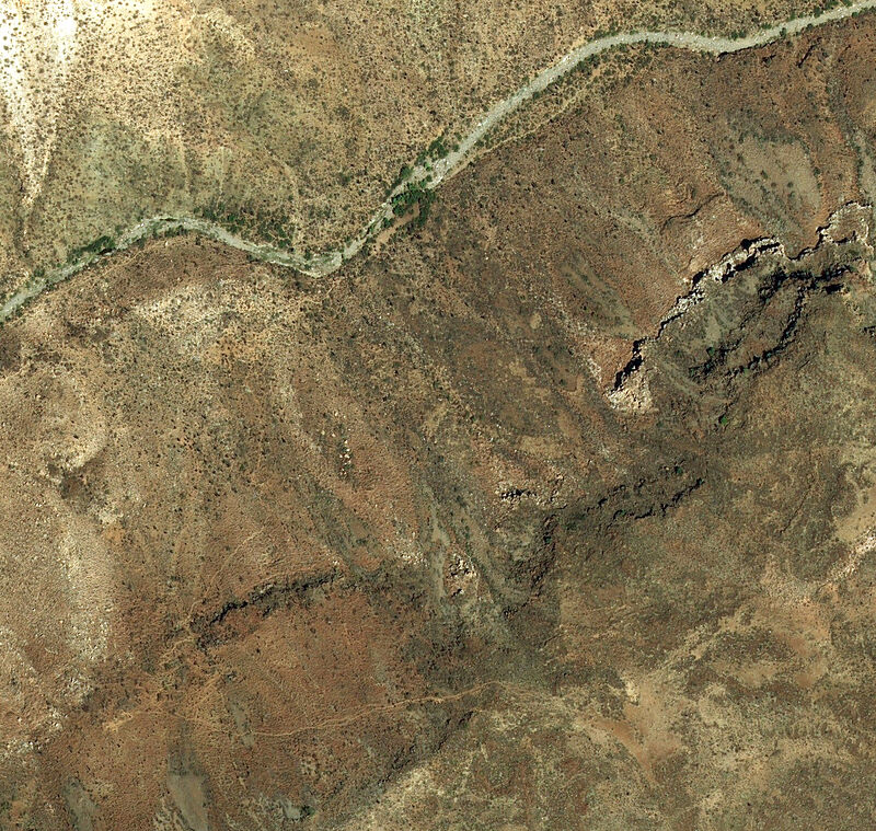
It looks like it connects a well-worn area with vegetation down by the riverbed to a well-worn area at the top of the mesa, but I don't see any trails
entering the area from elsewhere. There are also many other fainter switchback trails elsewhere on the mesa slope.
Here is a big image taken from Bing maps satellite. Click the following web-sized image to see big image:
|
|
|
4x4abc
Ultra Nomad
Posts: 4165
Registered: 4-24-2009
Location: La Paz, BCS
Member Is Offline
Mood: happy - always
|
|
this are the trails I have recorded in the area:
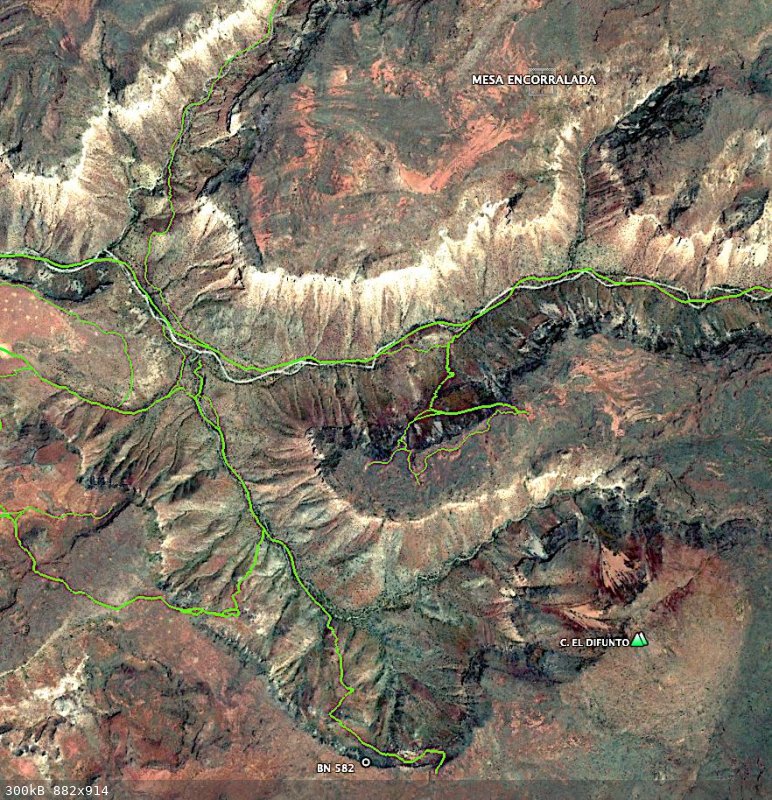
there is a lot of activity there
a Boleo cattle station is not far from there
Harald Pietschmann
|
|
|
geoffff
Senior Nomad
Posts: 643
Registered: 1-15-2009
Member Is Offline
|
|
I believe they are survey markers. The INEGI site mentions "estación geodésica: Vertical(BN) (EGV)" -- where I guess "N" stands for Norte (as in
direction, not Baja California "norte" - as they still say BN in BC Sur). Not sure abut the "B" part.
[Edited on 11-17-2021 by geoffff]
|
|
|
geoffff
Senior Nomad
Posts: 643
Registered: 1-15-2009
Member Is Offline
|
|
Quote: Originally posted by 4x4abc  | | this are the trails I have recorded in the area [...] there is a lot of activity there a Boleo cattle station is not far from there
|
Wow, you are really teasing out some faint details there! I can barely make these out on my image.
|
|
|
David K
Honored Nomad
Posts: 64488
Registered: 8-30-2002
Location: San Diego County
Member Is Offline
Mood: Have Baja Fever
|
|
I guessed BN was a benchmark...?
|
|
|
4x4abc
Ultra Nomad
Posts: 4165
Registered: 4-24-2009
Location: La Paz, BCS
Member Is Offline
Mood: happy - always
|
|
| Quote: Originally posted by geoffff |
I believe they are survey markers. The INEGI site mentions "estación geodésica: Vertical(BN) (EGV)" -- where I guess "N" stands for Norte (as in
direction, not Baja California "norte" - as they still say BN in BC Sur). Not sure abut the "B" part.
|
They are BN in all of Mexico
equivalent to the BM (bench mark) in the US
here is a list of all BN in Mexico
with detail sketches of the location:
https://www.inegi.org.mx/app/geo2/rgnp/
Harald Pietschmann
|
|
|
4x4abc
Ultra Nomad
Posts: 4165
Registered: 4-24-2009
Location: La Paz, BCS
Member Is Offline
Mood: happy - always
|
|
here is the detail for the one in my image
BN582 (200616 on the list)

Harald Pietschmann
|
|
|
David K
Honored Nomad
Posts: 64488
Registered: 8-30-2002
Location: San Diego County
Member Is Offline
Mood: Have Baja Fever
|
|
Cool... so I guessed right! Thanks Harald, interesting!
|
|
|
mtgoat666
Select Nomad
Posts: 17327
Registered: 9-16-2006
Location: San Diego
Member Is Offline
Mood: Hot n spicy
|
|
| Quote: Originally posted by lencho | | Quote: Originally posted by geoffff | | The INEGI site mentions "estación geodésica: Vertical(BN) (EGV)" -- where I guess "N" stands for Norte (as in direction, not Baja California "norte"
- as they still say BN in BC Sur). Not sure abut the "B" part. |
We can guess till the cows come home, but
it's mostly noise. 
After some inquiry, I've learned that "Banco de Nivel" is the Spanish term for a benchmark. Thus the abbreviation "BN".
Edit: BTW, while we're here, the (EGV) is Estación Geodésica Vertical. 
[Edited on 11-18-2021 by lencho] |
Is BN just for vertical benchmarks? I only see BN with EGV, not EGH.
Woke!
“...ask not what your country can do for you – ask what you can do for your country.” “My fellow citizens of the world: ask not what America
will do for you, but what together we can do for the freedom of man.”
Prefered gender pronoun: the royal we
|
|
|
4x4abc
Ultra Nomad
Posts: 4165
Registered: 4-24-2009
Location: La Paz, BCS
Member Is Offline
Mood: happy - always
|
|
| Quote: Originally posted by geoffff | | Quote: Originally posted by 4x4abc | | this are the trails I have recorded in the area [...] there is a lot of activity there a Boleo cattle station is not far from there
|
Wow, you are really teasing out some faint details there! I can barely make these out on my image. |
I have learned a lot about animal movement (including us) over the last years dissecting sat images
super interesting stuff!
how does that relate to Camino Real?
well, when the human animal stops using a trail, nature smoothes things out
trail almost disappear
almost, because the other animals will still use trails and roads we once created
so I trace animal trails because they sometimes help me find lost sections of Camino Real
many times I have kept myself from getting lost when exploring by looking for cow traffic
they go exactly where an old road used to be
a little trail cleaning and you keep going
good example in this trip:
https://carlosnpainter.smugmug.com/Events/La-Fortuna/
Harald Pietschmann
|
|
|
David K
Honored Nomad
Posts: 64488
Registered: 8-30-2002
Location: San Diego County
Member Is Offline
Mood: Have Baja Fever
|
|
Yes! I found the Camino Real where it climbs out of Arroyo Santa María, from the converging cattle prints!
In Nov. 2002:

Here it is!!! N29°41.733' W114°28.175' (NAD27)
|
|
|
4x4abc
Ultra Nomad
Posts: 4165
Registered: 4-24-2009
Location: La Paz, BCS
Member Is Offline
Mood: happy - always
|
|
thank you for making my point
Harald Pietschmann
|
|
|
| Pages:
1
2 |


