| Pages:
1
2 |
100X
Nomad
 
Posts: 234
Registered: 11-3-2021
Member Is Offline
Mood: Thankful
|
|
Tabor/Steinbeck Canyon Hike
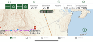
Yesterday I hiked into Tabor Canyon. I began about 8:30 in the morning and was back at 5:00. In a straight line, I made it less than 2 miles, but GAIA
had my trip at 3.54 miles one way, and Strava had it at 5.85 miles one way. Looking at my tracks, I did do quite a bit of meandering around to get as
far as I did. The canyon keeps on going from where I turned around, but it was quite overgrown and I wanted to make sure I had enough time to return
before dark.
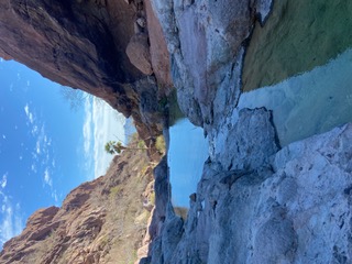
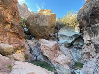
Even though Loreto received about a half and inch of rain two days beforehand, there was little sign of it in the canyon. The lower pools were mostly
empty, but the pools and water increased as I got further in. There were a number of ropes and even a ladder to help with the difficult climbs. All
went well, though there are a couple ropes that are getting close to the end of their useful life and care should be taken.
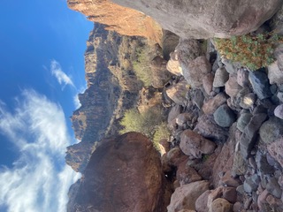
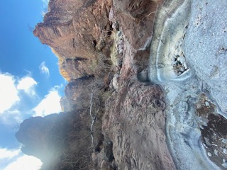
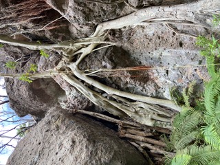
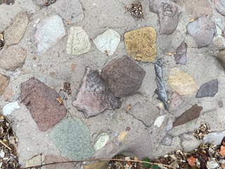
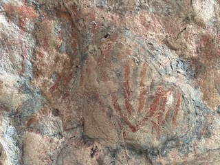
The scenery and views are just spectacular. Photos can not come close to showing either the scale or the beauty of what is pictured. The rocks, some
larger than a house, with their multi-colored history of volcanic and flooding violence are beyond anything I have seen anywhere. Even though
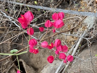
November, there were many flowers in bloom, full green palm oases, tadpoles, frogs, and even a few tarantulas. Despite keeping my eyes peeled for
snakes, I did not see any.
The hike is not for the faint of heard, but even just going in a few hundred yards and returning is very worthwhile (plus one could then stop by Vista
al Mar/Clam Shack on their way back to Loreto).
Am now tempted to get an earlier start and bring a machete to see If I can get the last (next?) half mile or so. I have also read that from that point
there is a spire one can climb to see the Sea of Cortez and Pacific from the same spot, although I personally doubt this is possible short of a very
involved expedition with full climbing gear.
This one is highly recommended!
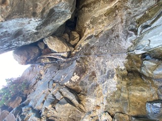
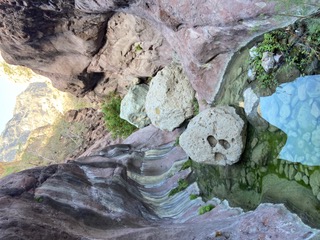
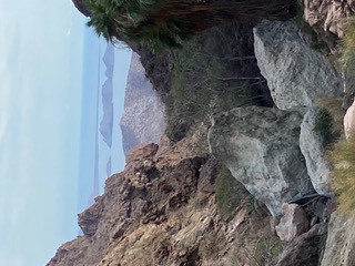
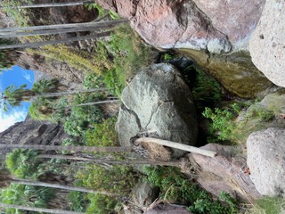
[Edited on 11-29-2021 by BajaNomad]
A life of fears leads to a death bed of regrets.
Find someone who will take care of you, and take care of them.
|
|
|
100X
Nomad
 
Posts: 234
Registered: 11-3-2021
Member Is Offline
Mood: Thankful
|
|

[Edited on 11-29-2021 by 100X]
A life of fears leads to a death bed of regrets.
Find someone who will take care of you, and take care of them.
|
|
|
100X
Nomad
 
Posts: 234
Registered: 11-3-2021
Member Is Offline
Mood: Thankful
|
|
Okay, now will try to resize with the =800x approach. Sorry.
A life of fears leads to a death bed of regrets.
Find someone who will take care of you, and take care of them.
|
|
|
David K
Honored Nomad
        
Posts: 64479
Registered: 8-30-2002
Location: San Diego County
Member Is Offline
Mood: Have Baja Fever
|
|
The width limit (800x) is for photos hosted on another website (like Postimages.org) as for photos attached on Nomad, well they have a file size limit
0f 342 kb. I am not sure why your image attempt is looking like that?* Where are the photos at, if not your PC? There should be a link with an [img]
tag for posting from other sites or use the Nomad image tool:

* I sent Doug a message and I see he has opened the images... GREAT!
[Edited on 11-29-2021 by David K]
|
|
|
JZ
Elite Nomad
     
Posts: 9226
Registered: 10-3-2003
Member Is Offline
|
|
Sweet. Can you drop coordinates of where this is? Or even upload a track?
|
|
|
100X
Nomad
 
Posts: 234
Registered: 11-3-2021
Member Is Offline
Mood: Thankful
|
|
https://www.gaiagps.com/map/?loc=12.9/-111.3463/25.8031&...
Thank you everyone for all the help!
Hope I got the track uploaded correctly.
[Edited on 11-29-2021 by 100X]
A life of fears leads to a death bed of regrets.
Find someone who will take care of you, and take care of them.
|
|
|
JZ
Elite Nomad
     
Posts: 9226
Registered: 10-3-2003
Member Is Offline
|
|
Pretty cool. Track worked. I didn't see a way to download it, but maybe I'm just missing it.
Trail head is here: 25.79883, -111.33922
|
|
|
StuckSucks
Super Nomad
   
Posts: 2306
Registered: 10-17-2013
Member Is Offline
|
|
Quote: Originally posted by JZ  | | Pretty cool. Track worked. I didn't see a way to download it, but maybe I'm just missing it. |
Left column --> scroll down to Export, then you can select the download file format
|
|
|
JZ
Elite Nomad
     
Posts: 9226
Registered: 10-3-2003
Member Is Offline
|
|
Edit: I found the Export button. It's not of the far left panel, but the 2nd to left panel at the bottom.
[Edited on 11-29-2021 by JZ]
|
|
|
JZ
Elite Nomad
     
Posts: 9226
Registered: 10-3-2003
Member Is Offline
|
|
Has anyone ridden the wash from the canyon trail head to the beach?
Looks like a fun ride.
|
|
|
4x4abc
Ultra Nomad
    
Posts: 4163
Registered: 4-24-2009
Location: La Paz, BCS
Member Is Offline
Mood: happy - always
|
|
you were in Cañon Steinbeck
25°47'53.17"N, 111°20'35.56"W
Cañon Tabor here:
25°49'21.78"N, 111°21'24.11"W
but I don't remember my source - so, we could have another canyon discussion
nothing on INEGI
[Edited on 11-30-2021 by 4x4abc]
Harald Pietschmann
|
|
|
Skipjack Joe
Elite Nomad
     
Posts: 8084
Registered: 7-12-2004
Location: Bahia Asuncion
Member Is Offline
|
|
Quote: Originally posted by 4x4abc  | you were in Cañon Steinbeck
25°47'53.17"N, 111°20'35.56"W
Cañon Tabor here:
25°49'21.78"N, 111°21'24.11"W
but I don't remember my source - so, we could have another canyon discussion
nothing on INEGI
[Edited on 11-30-2021 by 4x4abc] |
google maps labels 25°47'53.17"N, 111°20'35.56"W as Tabor Canyon.
|
|
|
geoffff
Senior Nomad
  
Posts: 643
Registered: 1-15-2009
Member Is Offline
|
|
Yeah, the hiking people on the internet are calling 25°47'53.17"N, 111°20'35.56"W "Tabor Canyon". If it's a mistake, the mistake is propagating.
https://www.alltrails.com/explore/trail/mexico/baja-californ...
https://medium.com/loreto/tabor-canyon-hiking-adventure-tour...
https://www.visitloreto.info/hiking
This page https://www.discoverbaja.com/2018/03/03/puerto-escondido-tab... claims both names: "Tabor Canyon deserves a visit. Probably the most well-known
hike in the Loreto area, also referred to as Steinbeck Canyon, named for the famous author, traveler, and fisherman John Steinbeck"
|
|
|
David K
Honored Nomad
        
Posts: 64479
Registered: 8-30-2002
Location: San Diego County
Member Is Offline
Mood: Have Baja Fever
|
|
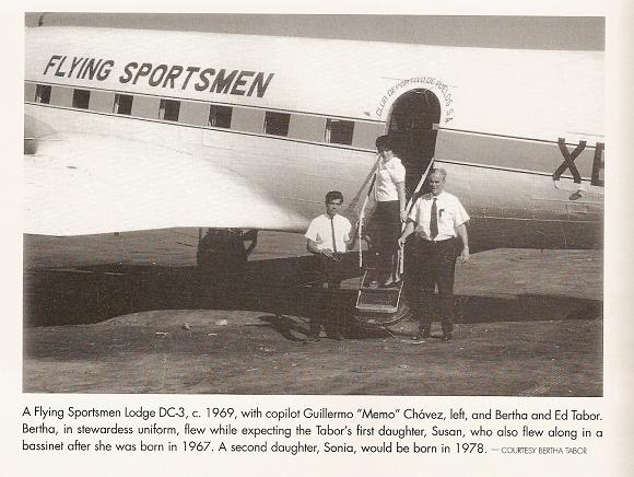
I was going to say that I think they are the same place. The map calls the mountain there 'Tabor' and thus the canyon gets that name, too. I wonder
where Harald found the named canyons? I also wondered if Sierra Tabor was named after the founder of Loreto's first resort, The Flying Sportsmen
Lodge?
|
|
|
4x4abc
Ultra Nomad
    
Posts: 4163
Registered: 4-24-2009
Location: La Paz, BCS
Member Is Offline
Mood: happy - always
|
|
Quote: Originally posted by geoffff  | Yeah, the hiking people on the internet are calling 25°47'53.17"N, 111°20'35.56"W "Tabor Canyon". If it's a mistake, the mistake is propagating.
|
the (non local) hiking people have renamed Arroyo Ligüi as Mezquite Canyon
25.708525°, -111.291807°
I'll keep hunting for sources
Harald Pietschmann
|
|
|
Bob and jane
Nomad
 
Posts: 272
Registered: 3-25-2004
Member Is Offline
|
|
Sorry,
Over 15 years ago while we were hiking in the canyon outside of Ligui, we asked a local who was hiking there what the name of the canyon was. He
said "Canon Mesquite". I believe that the (non Local) people called it Ligui Canyon, but the locals actually called it Canon Mesquite. We've seen
lots of changes there over the last 2 decades.
|
|
|
JZ
Elite Nomad
     
Posts: 9226
Registered: 10-3-2003
Member Is Offline
|
|
Quote: Originally posted by Bob and jane  | Sorry,
Over 15 years ago while we were hiking in the canyon outside of Ligui, we asked a local who was hiking there what the name of the canyon was. He
said "Canon Mesquite". I believe that the (non Local) people called it Ligui Canyon, but the locals actually called it Canon Mesquite. We've seen
lots of changes there over the last 2 decades.
|
Bob and Jane, thank you for the insight.
Please post more!
|
|
|
Mulege Canuck
Nomad
 
Posts: 386
Registered: 11-27-2016
Member Is Offline
|
|
Next time I go there, I have to bring new rope to replace some of those.
Nice spot for a day hike when we stay at Rattlesnake beach.
|
|
|
Bob and jane
Nomad
 
Posts: 272
Registered: 3-25-2004
Member Is Offline
|
|
JZ, I've written a dozen replies to you in my head. Canon Mesquite is one place that's really specially to my husband and I. But I'll try
objectivity. When we first started hiking there more than 20 years ago, the entrance was easier. The remains of an old seasonal hunting camp were
still visible around the mesquite tree near the entrance. The pool below the waterfall was shallower and often a makeshift, homemade ladder was
propped on the rock to the left of the waterfall and we could climb up to the floor of the canyon. Because the ladder wasn't reliably there, we
always carried our extension ladder to use. The floor of the canyon was much sandier back then. Always a trickle of water, but none of the really
deep pools there are now. In fact, we could wear tennis shoes. But carried sandals in case the water got ankle deep. We were able to go much
further into the canyon. At one point it looked as if the canyon hit a deadend but when you reached the deadend, you would see a narrow slot canyon
going off the the right. The high rock walls soon petered out. We would take a left up a side canyon and walk on slick rock. There was a huge
boulder that looked as if it would roll over at any moment. Our walks ended in thick brush soon after that. Once we saw a mountain lion there and
backed out slowly. I believe that a storm in about 2009 washed away the sand floor and created the deep cold pools that can make it difficult to get
all the way back into the canyon now. And the same storm changed the entrance to the canyon. Now we had to scale the rock face to the right of the
waterfall to get in. I always hyperventilated. I don't like high places. But always made it across. So proud of myself. We haven't gone into the
canyon in several years now. We've been traveling some and the years have robbed us of some agility. The road to the canyon was a bit different
every year. Sometimes we could drive all the way to the entrance and sometimes we had to park further away and walk. Arroyos are like that. All
those years hiking there we rarely saw another person. Twice, I think, we ran into a group from the eco-resort by Ensenada Blanca. Usually the only
sign of other humans was a random footprint in the mud. So amazing to be there. Last year we drove up to the canyon to check it out. First there is
now a gravel operation as you enter the canyon. Then the old road. Then we were shocked when we parked the truck to walk to the entrance. We had to
walk through a munchkin forest of those little rock towers that are all the rage now. There must have been hundreds of them!! Everywhere. It
couldn't have hurt more if someone had written graffiti over the canyon walls. I'm so glad we knew the canyon when it could still feel a bit wild.
Sorry, there went my objectivity.
|
|
|
David K
Honored Nomad
        
Posts: 64479
Registered: 8-30-2002
Location: San Diego County
Member Is Offline
Mood: Have Baja Fever
|
|
Thanks Jane, very interesting! We have camped on the shore Puerto Escondido as far back as summer of 1973 and fished with Ramon Villalejo out of
Juncalito in the 70s.
I didn't know about this canyon back then... Sounds great.
|
|
|
| Pages:
1
2 |

